The Development Code of Rexburg, Idaho began in-house in 2020 with the assistance of Municipal Code Corporation. This Development Code shall be cited as Rexburg Development Code or “RDC” as an acronym. (See Municipal Code for Ordinance Adoption.) RDC references found within the code maintain a structure by subject matter using a decimal numbering system which identifies the chapter and section (for example: 2.03.010). This complete set of numbers is designed to aid in searching and/or referencing the Development Code, and to assist in subsequent codification as new ordinances are added to the Development Code.
- The first number in the sequence (1) designates the CHAPTER level, as written in the table of contents
- The second series of numbers (1.1) designates the SECTION level, as written in the table of contents
- The last series (1.01.010) designates the Subsection level, and is expressed using three numerical values
The legislation herein may be arranged as an alphanumeric ordered list A, 1, a, (1), (A), (a) to show hierarchal relationships. The legislation may also be arranged as an unordered list (using bullets, discs, squares, etc.) to show items without hierarchal relationships. These list structures assist in subsequent codification as new legislation is added. Vacant titles, chapters, or sections may be designed for future use and may be marked “Reserved” to ease internal expansion. The legislative history identifies the specific legal sources of a section as may be provided in footnotes. The Development Code is supplemented from time to time with amendments and additions made by the City of Rexburg. The specific legal sources that comprise this Development Code have been adopted during the codification process from the original formatting of the official hard copy. In the event of discrepancies between the online Development Code and the official hard copy, the official hard copy governs. Municipal Code Corporation, provides a searchable database of the Development Code for easy reference and convenience.
The Current Development Code is Ordinance No 1200 as contained in this codification. The list of ordinances amending Ordinance No 1200 Rexburg Development Code is as follows:
- Ord No 1212 Dev Code Ord 1200 Amendment - PF Zone Ord Date 6/5/2019
- Ord No 1226 Dev Code Ord 1200 Amendment - Hwy 20 Interchange Sign Height to 50' Ord Date 6/17/2020
- Ord No 1237 Dev Code Ord 1200 Amendment - Remove Infill and Amend PED or PEZ and LDR3 Density Ord Date 11/4/2020
- Ord No 1241 Dev Code Ord 1200 Amendment - Infrastructure, Plat, and Lot Line Adj. for Subdivisions Ord Date 11/18/2020
- Ord No 1243 Dev Code Ord 1200 Amendment - TAG1 & TAG2 Into TAG Ord Date 1/6/2021
- Ord No 1244 Dev Code Ord 1200 Amendment - Repeal TOZ Ord Date 1/6/202
- Ord No 1248 Dev Code Ord 1200 Amendment - Planned Unit Development (PUD) Ord Date 2/17/2021
- Ord No 1251 Dev Code Ord 1200 Amendment - Design Standards, Landscaping, and Screening Ord Date 2/17/2021
- Ord No 1253 Dev Code Ord 1200 Amendment - Mixed Use (MU) Zone Ord Date 4/21/2021
- Ord No 1263 Dev Code Ord 1200 Adopt Chapter 9.4 Mobile Vending Ord Date 1/19/2022
- Ord No 1265 Dev Code Ord 1200 Amendment - Adopt Chapter 12 Form-Based Code Ord Date 10/6/2021
- Ord No 1279 Dev Code Ord 1200 Amendment - Remove CBD Ord Date 4/6/2022
- Ord No 1298 Dev Code Ord 1200 Amendment - Buffers, Fencing, Building Height, Reduction Parking PED, Manufactured Homes, & Short Plat Ord Date 6/7/2023
- Ord No 1302 Dev Code Ord 1200 Amendment - Livestock Permitted Zones Ord Date 9/6/2023
- Ord No 1304 Dev Code Ord 1200 Amendment - Sign Code Ord Date 12/20/2023
- Ord No 1306 Dev Code Ord 1200 Amendment - Permitted Uses Ord Date 12/20/2023
- Ord No 1308 Dev Code Ord 1200 Amendment - Miscellaneous & Rental Code Ord Date 2/21/2024
- Ord No 1318 Dev Code Ord 1200 Amendment - Tiny Homes Ord Date 9/4/2024
- Ord No 1320 Dev Code Ord 1200 Amendment - Fences and Billboards Ord Date 9/18/2024
- Ord No 1337 Dev Code Ord 1200 Amendment - Setbacks, Daycares Ord Date 10/1/2025
NOTICE: THE DEVELOPMENT CODE MAY NOT REFLECT ALL OR THE MOST CURRENT VERSION OF LEGISLATION ADOPTED BY THE CITY COUNCIL THAT HAS YET TO BE UPDATED ONLINE. IN THE EVENT OF CONFLICT BETWEEN THE DEVELOPMENT CODE AND A WRITTEN ORDINANCE, THE ORDINANCE TYPICALLY GOVERNS. ALSO, THE DEVELOPMENT CODE MAY NOT REFLECT RULES OR OTHER REGULATIONS PROMULGATED UNDER THE AUTHORITY OF THE CODE, INCLUDING TECHNICAL SPECIFICATIONS. FOR MORE INFORMATION CALL THE CITY CLERK.
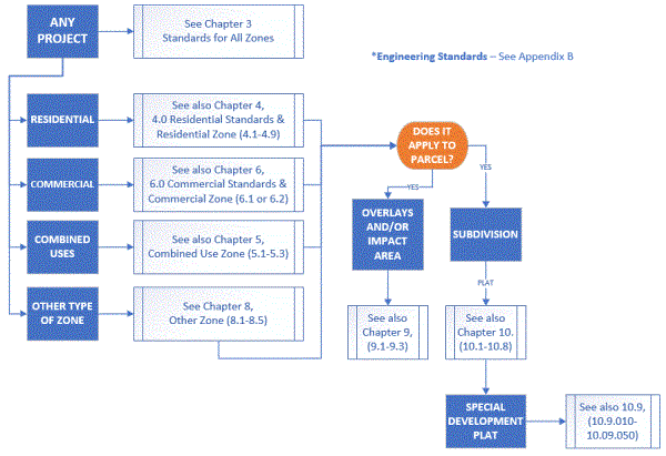
| USER GUIDE |
 |
Recorded by Ord. 390 Establish a Development Code on 3/16/1955
Repealed & Reenacted by Ord. 478 Repealed Ord. 390 as Amended by 436, 441, 443, 448, 452, 458, 471, 477 and all other Amendments on 5/3/1968
Repealed & Reenacted by Ord. 725 Repealed Ord. 478 and Ord. 685; Enacting Zoning Ordinance on 10/2/1991
Amended by Ord. 855 Repealed Ord. 478 and Ord. 685; Amended Ord. 725 on 6/6/2001
Amended by Ord. 864 Amended Ord. 725 Making Changes in the Use Table on 1/2/2002
Repealed & Reenacted by Ord. 926 Repealed Ord. 725, Ord. 866, Ord. 886, Ord. 894 and Ord. 915; Enacting a Development Code on 2/17/2005
Repealed by Ord. 1026 Repealed Ord. 926 on 11/4/2009
Repealed & Reenacted by Ord. 1115 Repealed and Replaced Ordinance 548, 642, 658, 915, 1021, 1027, 1095 and 1026 on 6/25/2014
Repealed & Reenacted by Ord. 1200 Repealed and Replaced Ord. 1115; Repealed Ord. 1132, Ord. 1154, Ord. 1157, Ord. 1159, Ord. 1177, Ord. 1181, Ord. 1188, Ord. 1196; Reorganization of Chapter and Sections to Improve Readability and Ease of Use. on 2/6/2019
1.2 FACILITATORS
1.3 COMMISSION, CITY COUNCIL
1.4 LAND USE ACTIONS
1.5 ENFORCEMENT PLAN
1.01.020 Authority
1.01.030 Purpose
1.01.040 Intent
1.01.050 Applicability
1.01.060 Previous Ordinances And Maps
1.01.070 Severability
1.01.080 Relationship To Other Laws
1.01.090 Violation And Penalties
1.01.100 General Procedures
This Ordinance shall be known and entitled as “The City of Rexburg Development Code” and may be so cited and pleaded.
This Ordinance is adopted pursuant to authority granted by Title 67, Chapter 65 of the Idaho Code (I.C.), and Article 12, Section 2 of the Idaho Constitution, as amended.
The purpose of this Ordinance shall be to promote the health, safety, and welfare of the residents of the City of Rexburg as follows:
- To protect property rights and enhance property values.
- To provide for the protection and enhancement of the local economy.
- To ensure that important environmental features are protected and enhanced.
- To encourage the protection of prime agricultural lands for the production of food.
- To encourage concentration of population in urban areas with the goal of enhancing the quality of life for the community.
- To ensure that development is commensurate with the physical characteristics of the land.
- To protect life and property in areas subject to natural hazards and disasters.
- To protect recreation resources.
- To avoid undue water and air pollution.
- To maximize the use of existing infrastructure including roads, utilities, sewers and water facilities.
- To secure safety from fire and provide adequate open spaces for light and air.
- To implement the Comprehensive Plan.
The purposes of these regulations may be achieved through the following objectives:
- Harmonious development of the area.
- Coordination of streets and roads within subdivisions with other existing or planned streets and roads.
- Adequate open space for travel, light, air and recreation.
- Conservation of or provisions for adequate transportation, water drainage, and sanitary facilities.
- Avoidance of population congestion as would involve danger or injury to health, safety, or general welfare by reason of:
- Lack of water supply, drainage, transportation, or other public services; or
- Unnecessary imposition of an excessive expenditure of public funds for the supply of such services.
- Establish requirements as to the extent and manner in which roads shall be created and improved; and water and sewer and other utility mains, piping connections, or other facilities shall be installed as conditions precedent.
- Planning and platting large areas before development.
- Defining the powers and duties of approval authorities; including procedures for the equitable review and approval of all plats or subdivisions covered by these provisions.
It is the intent of the governing body of the City of Rexburg that this Ordinance be interpreted and construed to further the purposes of this Ordinance and the objectives and characteristics of the zoning districts.
The provisions of this Ordinance are applicable not only to private persons, agencies, and organizations but also to all public agencies and organizations to the full extent that they may be enforceable.
The existing ordinances covering the zoning of the property within the limits of the City of Rexburg together with all maps which are part of such ordinances are hereby superseded. Any illegal or unauthorized use of land, buildings or structures shall remain illegal and unauthorized unless specifically authorized under this Ordinance.
If any portion of this Ordinance or its application to specific circumstances shall be held invalid by a court of competent jurisdiction, the remainder of this Ordinance and its application to other circumstances shall be unaffected.
If State or Federal law or regulations or other City ordinances impose additional or duplicative standards on development or buildings regulated by this Ordinance, the more restrictive standard shall apply.
No structure or land shall hereafter be constructed, located, extended, converted, or altered without full compliance with the terms of this ordinance and other applicable regulations.
- Whenever a violation of this Ordinance occurs, or is alleged to have occurred, any person may file a complaint with the Zoning Administrator.
- The Zoning Administrator or his agent shall record such complaint, investigate the same, and take such action or cause such action to be taken as provided by this Ordinance.
- The City Attorney may, in addition to taking whatever criminal action is deemed necessary, take steps to civilly enjoin any violation of this Ordinance.
- Any violation of the provisions of this Ordinance or any failure to comply with any of its requirements shall constitute an infraction.
- Each day such violation continues beyond notice, shall be considered a separate violation.
- The land owner, tenant, sub-divider, builder, public official, or any other persons who commit, participate in, assist in, or maintain such violations may each be found guilty of a separate offense.
- Any person convicted of violating the provisions of this Ordinance shall be assessed a penalty not to exceed three hundred dollars ($300) per violation.
- Nothing herein contained shall prevent the City of Rexburg from taking such other lawful action as is necessary to prevent or remedy any violations.
- Attorney Fees and Costs. The City may seek injunctive relief through the courts for enforcement of the provisions of this Ordinance and, in addition to the relief sought, shall also be entitled to its attorney’s fees and costs.
Development ideas and applications will proceed through the following bodies for consideration in the City of Rexburg:
- Economic Development Team
- Strategic Development Team
- Application to Development Review Committee
- Design Review Board (If needed)
- Planning & Zoning Commission
- City Council
1.02.020 Ready Team
1.02.030 Strategic Development Team
1.02.040 Development Review Committee
1.02.050 Design Review Board
1.02.060 Historical Preservation Commission
Repealed & Reenacted by Ord. 1200 Replaced Ord. 1115 with Amendments; Clairified Duties and Responsibilities of Facilitators on 2/6/2019
There is hereby created the position of City of Rexburg Zoning Administrator.
- The Zoning Administrator shall be appointed by the Mayor and confirmed by the City Council.
- The Mayor may appoint another officer of the City, including but not limited to the City Clerk, Zoning Administrator, Building Official, to fulfill all or part of the duties of the Zoning Administrator.
- Duties of the Zoning Administrator. The Zoning Administrator shall administer the provisions of this Ordinance, provide assistance to and guidance to the Commission and Council, and have the following duties:
- Advise interested persons of the Development Code provisions.
- Notify the news media regarding matters of public interest.
- Aid and assist applicants in the preparation and processing of applications.
- Review. The Zoning Administrator or a designee will review all plans and applications for compliance to the Rexburg Development Code.
- Assist Commission and Council. Review and assist the Commission and Council in reviewing applications for home occupations, variances, conditional use permits, rezoning requests, subdivisions, planned unit developments and annexations.
- Interpret Code. In administering this ordinance, the Zoning Administrator may make interpretations of any part of this code, which interpretations are binding but may be appealed to the Design Review Board, the Mayor, or the Planning and Zoning Commission.
- Chief Enforcement Officer. The Zoning Administrator shall serve as Chief Enforcement Officer of this Title, and carry out the enforcement authorities of the Commission under Subsection 1.030.020.
- Ordinance Violations. Investigate violations of this Ordinance and notify in writing the person responsible for such violations, ordering the action necessary to correct such violation.
- Field Officers. The Zoning Administrator shall direct and administrate the efforts of any, and all, Field Service Officers assigned to the Administrator to assist him in performance of his duties of investigations, process services, and notifications.
- Authority. The Zoning Administrator shall receive and direct, all appellate matters to the appellate authority of jurisdiction, including scheduling and coordinating all appeal hearings in regards to this Title.
New businesses, new major developments, new developers to the City of Rexburg, and developers needing assistance with city administration and city processes may approach the Ready Team for informal advice and direction. Such discussion shall be preliminary to the application and only advisory to both parties.
- Objective. The objective, to be implemented through their procedures and deliberations, shall be to encourage development quality that will enhance both the natural and built environments, with consideration to present and future property values.
- Members. Members of the Ready Team shall be the Economic Developer, the Zoning Administrator, Building Official, Fire Official, Legal Counsel, the City Engineer and others as requested.
- It is recommended that the applicant discuss the application informally with the Ready Team prior to formal submission to help expedite the process. Depending upon the size of the proposed project, its location and type, the applicant may be directed to one or more agencies of the City for processing.
Large scale development that impacts surrounding projects, will need to be submitted to the Strategic Development Team prior to submittal of an application to the Development Review Committee.
- The purpose of the Strategic Development Team is to coordinate all entities within the City for development.
- Members of this group include the Zoning Administrator, Economic Development Director, City Engineer, City Clerk, City Attorney, and City Mayor.
- An informal review by the Strategic Development Team may be requested by submitting a Meeting Request form and any schematic development plans at least one week prior to the next scheduled Strategic Planning Team meeting.
The Development Review Committee is established to evaluate all proposals subject to the provisions of this Title. The Development Review Committee is the body charged with reviewing items relating to public health and safety with consideration to coordinate, expedite and assure fair and equitable implementation of this Title.
- Policies and Procedures
- The Development Review Committee shall act as an advisory body to the Zoning Administrator for site plans when no variance or deviation is requested.
- Members. The Development Review Committee shall consist of the Zoning Administrator, GIS Department Head, City Engineer, Fire Department Inspector, Building Administrator or designees.
- Advisory. The Development Review Committee shall act as an advisory body to the City Council for larger and more complex proposals including conditional use permits, planned unit developments, all Lot Layout Plans involving variances or deviations, divisions of land, zone map amendments, annexations and other actions as requested by Staff or the City Council.
- Denial Authority. Each department charged with development review shall have the ability and authority to require the Zoning Administrator to make a recommendation of denial when in their view the project cannot meet the requirements and review criteria of this Title and acceptable conditions do not exist to cure the identified failings of the project.
- Record. Each of the Development Review Committee Members will input their reviews and comments into the City permitting system or provide them to the Planning & Zoning Assistant following their project review. These records shall be preserved as part of the official file for each development proposal.
- All bodies authorized under this chapter may call upon any City staff or other persons with technical expertise, and may testify before any board, commission or other body upon the subjects for which they have responsibility.
- Inquiry. A person or organization considering any construction, building or site alteration, rezoning or other development activity, may approach the City Planning & Building Department for informal advice and direction. Such discussion shall be treated as advisory by both parties and a general record of the meeting shall be created.
- Pre-Application. An informal review by the City Planning & Building Department may be requested by submitting a Meeting Request form provided by these departments along with any schematic development plans at least one week prior to the meeting.
- Application. An application for consideration of a development proposal must be submitted utilizing a form available from the Zoning Administrator or designee.
- Materials to be submitted with the application shall include the elements set forth within the requirements for the type of proposal to be considered, (i.e., sketch plan, Infrastructure Plan, Conditional Use Permit, Planned Unit Development, divisions of land, rezone, annexation, etc.) as outlined in this title.
- Fees. Fees for permits issues under this Ordinance and requests for amendments to this Ordinance shall be reviewed and changed by resolution of the City Council and Mayor at such time as deemed necessary.
- A fee may be assessed for any service, including but not limited to the following:
- Construction inspection fee
- Notice and publication costs
- Office checking and field engineering
- Subdivision plat filing fee
- Costs for inspection, testing, and quality control are to be paid to the City by the developer at rates established by resolution of the Council.
- Application Fee. The initial formal review by an applicant or owner for a specific parcel shall be conducted with an application fee.
- 2nd Fee. A fee, set in accordance with the fee resolution adopted by the City Council, shall be charged for a third or subsequent formal review requested by the same applicant and/or owner for the same real property as a prior formal review.
- Re-inspection fees. A re-inspection fee may be assessed for each re-inspection when such portion of work for which inspection is called for is not completed or when corrections called for are not made with the allotted time.
- Work commencing before permit issuance. Any person who commences any work, activity or operation regulated by this code, before obtaining the necessary permits shall be subject to an additional fee established by the applicable governing authority, which shall be in addition to the required permit fees.
- Exception: An exception shall be granted for emergency repair work performed during off-business hours. Emergency repair work shall be work similar in nature to repairing frozen or physically damaged piping in order to return a system to service.
- Impact Area Fees. In the area of city impact, all administrative fees shall be established by the City and paid to the City. In the event costs are incurred by the City of Rexburg as a result of the administration or enforcement of area of city impact matters, the City of Rexburg and County agree to share equally such expenses.
- A fee may be assessed for any service, including but not limited to the following:
Amended by Ord. 1157 Amended Ord. 1115; Named Development Review Committee on 3/1/2017
Amended by Ord. 1248 on 2/17/2021
The Design Review Board is established to review design standards, landscaping, and Infrastructure Plans when requested.
- Authority.
- Zoning Administrator Review. The Planning and Zoning Commission delegates the authority required to make a best effort, design review to the Zoning Administrator or a designee. It is the intent that the Zoning Administrator or a designee reviews the application and all submitted plans for compliance to the Design Standards as set forth in the Rexburg Development Code.
- When the Design Requirements are not met, the applicant will be advised of the shortcoming and will be advised to either make the necessary changes for compliance or meet with the Design Review Board.
- Initiating a Meeting
- Disagree with Zoning Administrator Review. If at any time, the person submitting the plans does not agree with the review performed by the Zoning Administrator or a designee, he/she may request a hearing by the Design Review Committee.
- Zoning Administrator Request. If the Zoning Administrator or designee performing the design review feels that input is required from the Design Review Committee, he/she can request that the Design Review Committee meet and discuss the proposal.
- Commission Request. The Planning and Zoning Commission at any time may request that a Design Review Board be called together for a certain project review or as a re-review on a project completed by the Zoning Administrator or a designee.
- Organization
- The Design Review Committee is made up of three (3) pools of individuals from:
- The Planning and Zoning Commission (pool of all members)
- The City Council and Mayor (pool of all members)
- Professional Group (group of ten)
- Three (3) members of the committee should be present for project design review. The Planning and Zoning Assistant shall attempt to build a three (3) member committee by calling one (1) member from each pool.
- If the attempt is not successful, then the group may consist of three (3) members of any combination of the pools.
- If at the time of the meeting some or all of the members of the committee do not show, then two of the remaining members and/or City Staff may act as the committee.
- The Zoning Administrator shall recommend potential members from the private sector for inclusion into the Professional Group to the Mayor.
- The Design Review Committee is made up of three (3) pools of individuals from:
- Meeting Procedures. To implement this purpose, certain procedures shall be adopted to include, but not be limited to, meetings attended by members of the Design Review Board. After introductions, the meeting will proceed as follows:
- The meeting is headed by the Commissioner present. If there is no Planning and Zoning Commissioner present, then the City Council member in attendance presides.
- The City Plan Reviewer or designee outlines the specifics on why the current drawings do not meet the prescriptive design requirements of the Development Code.
- Each section of the design requirements is reviewed by the Board.
- The applicant explains how the design meets the intent of the Design Review Requirement.
- The Board deliberates and comes to a conclusion on an allowed design.
- Written meeting reviews setting forth decisions and findings shall be made. These records shall be preserved as part of the official proceedings for each developmental proposal.
- The written meeting reviews are sent to all parties present at the meeting on the first possible date.
- After follow-up with Board on written meeting review, the review is attached and included with the Building Permit for the project.
- The building plans are redrawn or redlined to identify the changes made by the Board.
- All subsequent reviews are completed with the new plans.
- Action. By no later than 30 working days from the date of the first regularly scheduled Development Review Committee at which the applicants’ proposal was initially reviewed, the Development Review Committee, shall take action to recommend approval, approval with conditions, table pending submission of revised or additional materials or recommend denial of the applicant’s proposal, unless the applicant grants a written extension to the review period.
The Historical Preservation Commission, either on its own initiative, or upon the request of the City Council, or upon the request of one or more owners of property residing in the area of a proposed historical district, may recommend the designation of one or more historical districts.
- The Historic Preservation Commission shall consist of seven (7) members who shall be appointed by the Mayor with the advice and consent of the City Council. Members of the Commission shall be appointed with due regard to the proper representation of such fields as history, architecture, urban planning, archaeology and law.
- The term of appointments shall be three (3) years..
- The term of appointments shall be three (3) years..
- Prior to recommending designation the Commission shall conduct studies, research and investigations based on the relevant criteria given in Section 2-18-7A regarding buildings, structures, features, sites, objects and surroundings of such proposed historical district or districts. Thereafter the Commission shall prepare a report containing recommendations concerning the area or areas to be included in the proposed historical district or districts.
- Historic landmarks shall meet the criteria established for inclusion in the National Register of Historic Places and the Historic Sites Review Board of the State of Idaho.
- Historical districts will need to follow the rules for alterations or change found in 2-18-9.
- Historic landmarks shall meet the criteria established for inclusion in the National Register of Historic Places and the Historic Sites Review Board of the State of Idaho.
- The Historical Preservation Commission shall transmit their review and recommendation to the City's Planning & Zoning Commission. The City's Planning & Zoning Commission will hold a public hearing.
1.03.020 Duties Of The Commission
1.03.030 Membership And Term Of The Commission
1.03.040 Organization Of The Commission
1.03.050 Public Hearing Notice
1.03.060 Conflict Of Interest
1.03.070 Hearing Procedures
1.03.080 Meetings Of The Commission
1.03.090 City Council
1.03.100 Appeals
There is hereby created a Planning and Zoning Commission. The Planning & Zoning Commission is referred to in this Ordinance as the Commission.
- The Commission shall have the authority to consider and recommend to the Council ordinances, amendments thereto, and repeal of ordinances affecting zoning, planning, and building within the City of Rexburg.
- Hold Public Hearings. The Commission shall provide guidance and assistance to the Council, hold public hearings as required by law, and shall grant or deny applications presented to the Commission.
- Recommendations to City Council. The Commission shall make timely recommendations to the Council in all matters relating to this Ordinance in which the Council has final decision making powers.
- Any action taken by the Commission, which will be final, unless appealed, may be reviewed by the Council at their discretion, within twenty (20) days of Commission action, if the Council believes there may be significant adverse impact as a result of Commission action.
The Commission shall have the following duties, as well as such others, prescribed by law or assigned by the Council:
- Comprehensive Plan. Conduct a comprehensive planning process designed to prepare, implement, review and update a Comprehensive Plan.
- Biannual. Conduct a biannual review of this Ordinance and its implementation of the Comprehensive Plan.
- Conditional Use Permits. Grant conditional use permits as specified in this Ordinance and make recommendations to the Council on those conditional use permits for which the Council has final decision making powers.
- Mitigating Land Use Impacts. Any change of use that creates more intense impacts may be denied if the Planning and Zoning Commission finds that such impacts cannot be mitigated by the imposition of conditions. Land use impacts that may need to be mitigated include the following:
- An increase in daily or peak hour traffic.
- A change in circulation patterns on or around the property.
- A significant increase in the demand for parking.
- A change in the density of people on site.
- Expansion of the hours of operation.
- Any increased environmental impact, such as noise or air pollution; offensive odors; excessive illumination or glare, etc.
- Proposed Amendments. Review all proposed amendments to this Ordinance and make recommendations to the Council. Initiate proposed amendments to this Ordinance.
- Reviews. Complete Plat and design standard reviews as provided for in this Ordinance.
- Rules and Regulations. The Commission is authorized by the City of Rexburg and Madison County to administer and enforce all rules and regulations pertaining to the Area of City Impact for the City of Rexburg as provided in Section 9.2 hereof.
- Variances. Grant variances as authorized by this Ordinance and Idaho statutes.
Recorded by Ord. 353 Established duties of the P&Z Commission on 2/12/1946
Amended by Ord. 1248 on 2/17/2021
The Commission shall consist of eleven (11) members, eight (8) of whom shall reside within the city limits of Rexburg and be appointed by the Mayor and confirmed by the Council; three (3) members to be appointed who reside within the Area of City Impact defined in City Ordinance No. 770.
- The three residing in the Area of Impact shall be appointed, one by the Mayor and the other two shall be appointed by the Madison County Commissioners.
- The Mayor shall ask and receive names of persons to serve on the Commission.
- The length of term is three (3) years.
- The terms shall be staggered.
- Resident. The eight (8) members residing in the City shall have resided in Rexburg two (2) years prior to appointment and must remain a resident of the City during service on the Commission.
- Vacancies. Vacancies occurring otherwise than through the expiration of terms must be filled in the same manner as the original appointment. A member appointed and fulfilling an unexpired term shall serve the remainder of the term.
- Members of the Commission may be removed for good cause by a majority vote of the full council.
- Members of the Commission may receive such mileage and per diem compensation as provided by the Council.
- Impact Area Enforcement. The City of Rexburg and Madison County authorize the Rexburg Planning and Zoning Commission to be the enforcing agency responsible for enforcing compliance with the provisions of this ordinance within the Area of Impact. Enforcement policies and procedures shall be in compliance with the authorities and duties of the Zoning Administrator, acting as Chief Enforcement Officer for the Commission.
- Area of Impact Voting. In matters pertaining to the Area of City Impact, a vote of the three (3) members residing in the Area of City Impact, in the aggregate, shall have the same weight as the vote of the remaining seven (7) members of the Commission residing in the City of Rexburg, in the aggregate.
Recorded by Ord. 353 7 Members of the Planning Commission including the Mayor and length of appointments on 2/12/1946
Amended by Ord. 376 Commission terms of service - 6 months on 5/23/1951
Amended by Ord. 770 Add Chapter 10 Area of City Impact; Amended Ord. 725 Adjusted Membership of the Commission, Appeal Process, Fee Agreement on 2/15/1995
Approved by Ord. 769 Established Area of City Impact on 2/15/1995
Amended by Ord. 880 Amending Area of City Impact boundaries on 7/17/2002
Amended by Ord. 1150 Amended Area of City Impact boundary on 10/5/2016
The Commission shall elect a chairman and may create and fill any other office it deems necessary.
- The Commission may establish subcommittees, advisory committees or neighborhood groups to advise and assist in carrying out its responsibilities under this Ordinance.
- The Commission may appoint non-voting ex-officio advisors as deemed necessary.
The public hearing shall be noticed as required by state statutes.
- Newspaper Notice. At least fifteen (15) days prior to the hearing, notice of the time and place and a summary of the amendment shall be published in the official newspaper or paper of general circulation within the jurisdiction of Rexburg.
- Mailing Notice for Map Revision. If the amendment is a map revision, additional notice shall be provided by mail to property owners or purchasers of record of land within three hundred feet (300') of the external boundaries of land being considered.
- PUD. Buffer boundary for mailing is increased for Planned Unit Developments (PUD). (See 1.04.040.B.1.a.)
- PUD. Buffer boundary for mailing is increased for Planned Unit Developments (PUD). (See 1.04.040.B.1.a.)
- Posting. Notice shall also be posted on the property to be rezoned not less than one (1) week prior to the hearing.
- 200 or More Land Owners. When notice is required to two hundred (200) or more property owners or residents, notice of the proposed change and the hearing shall be published in the official newspaper once a week for two (2) consecutive weeks, with at least one of the publications being fifteen (15) days prior to the date set for hearing on the proposed change.
A member of the Commission shall not participate in any proceeding or action when the member, his employer, business partner, business associate, or any person related to him by affinity or consanguinity within the second degree has an economic interest in the procedure or action.
- An actual or potential interest in any proceeding shall be disclosed at or before any meeting at which the action is being heard or considered.
- Such disclosure shall be recorded in the minutes.
Hearing Procedures. The following shall be observed in the conduct of public hearings before the Planning and Zoning Commission and the Council:
- Recorded. All public hearings shall be recorded electronically or steno-graphically and all persons testifying shall speak in such a manner to assure that the recorded testimony or remarks will be accurate and trustworthy.
- Purpose and Subject. The chairperson shall announce the purpose and subject of the hearing.
- Conflict of Interest. The chairperson may ask if any members have a conflict of interest and wish to be excused from this portion of the meeting. (See subsection 1.03.060)
- Applicant Presents Proposal. The chairperson shall ask the applicant to explain the proposal being considered.
- Questions. The chairperson shall entertain questions from the Commission members regarding the proposal.
- Staff Report. The chairperson shall ask the Zoning Administrator or designee if there is any additional discussion needed for clarification.
- Related Testimony. The presiding officer may note, prior to opening the public hearing that testimony should relate to whether the proposal before the hearing body is in accordance with the Comprehensive Plan, the Development Code, and other standards of the City.
- Time Limit. The hearing body may establish a time limit to be observed by all speakers, depending upon the number of those who wish to testify. Such a time limitation shall apply to all speakers’ comments.
- Open Public Hearing. The chairperson shall ask for statements from others in the audience.
- Recognized. No person shall be permitted to speak until such person has been officially recognized by the presiding officer.
- Sign-up Sheet. The Administrator may require that those who wish to testify complete a sign-up sheet with name and address prior to giving testimony.
- State Name and Address. Each person testifying shall be asked to state his/her name and address in such a manner as to assure that it will be recorded by electronic means.
- Questions. At the conclusion of a speaker’s comments, each member of the hearing body may address questions to the speaker. If a time limit has been set, such questions and answers shall not be included in the time limit.
- Rebuttal. When all statements have been given, the chairperson shall afford anyone who has previously given a statement to speak in rebuttal or clarify his/her earlier statement.
- Close Public Hearing. After such rebuttal and clarification, the chairperson shall close the public hearing and ask for comments from the Commission members. Such discussion shall lead to action by the Commission.
The Chair presides at all regular meetings of the Commission which may be scheduled on the first and third Thursday of each month for no less than nine (9) months in a year.
- All meetings and records shall be open to the public and a record of all meetings, hearings, resolutions, studies, findings, permits, recommendations, and actions shall be maintained by the Commission.
- A quorum of the Commission shall consist of six (6) members.
- The Commission may prepare and adopt supplemental procedural rules, upon the approval of the City Council, that will assure the accomplishment of the stated purpose and promote the efficiency and effectiveness of the design review process.
- Commission Action. The Commission may recommend that the amendment be granted as requested, that it be modified, or that it be denied.
Within sixty (60) days of the public hearing, the Commission shall transmit its recommendation to the Council.
- Action by Council. Upon granting, modifying, or denying a request for amendment, the Council shall specify:
- The provisions of this Ordinance and the Comprehensive Plan and other standards used in evaluating the application.
- The reasons for approval or denial.
- The actions, if any, the applicant should take to obtain an amendment of the Ordinance.
- Planning & Zoning Commission Rejects Amendment. The final decision of the Commission may be appealed to the Council by submitting a written appeal to the City Clerk within fifteen (15) days of the decision of the Commission. Decisions of the Council may be appealed as provided in Idaho Code Section 67-6521.
- Impact Area. Any affected person may appeal a final decision of the Commission relating to matters arising within the Area of City Impact.
- Authority. The Zoning Administrator shall receive and direct appeals for the Impact Area, including scheduling and coordinating.
- Board of Appeals. Said appeal shall be heard by a board of appeals consisting of two members appointed by the county and two members appointed by the city.
- Time Limit. Any appeal from a decision pertaining to the Area of City Impact must be submitted by written notice to the Clerk of the Commission within fifteen (15) days of the decision of the Commission.
- Impact Area. Any affected person may appeal a final decision of the Commission relating to matters arising within the Area of City Impact.
- City Council Rejects Amendment. When the City Council rejects a Comprehensive Plan Map or a zone change recommendation from a public hearing that was held at a Planning and Zoning Commission meeting, another public hearing shall be required to be held at the next available City Council meeting.
- Commissioners Request Additional Hearing. During a Comprehensive Plan map or a zone change hearing, the Planning and Zoning Commission at their discretion can request an additional public hearing be held at a future City Council meeting.
Repealed & Reenacted by Ord. 1115 Repealed Ord. 548, 642, 658, 915, 1021, 1027, 1095 and 1026; Development Code; A Public Hearing at City Council shall be required with the Council rules differently than the Planning and Zoning Commission; An additional Public Hearing can be held at City Council for any reason. on 6/25/2014
1.04.020 Amendments To This Ordinance
1.04.030 Conditional Use Permits
1.04.040 Subdivisions
1.04.050 Vacations
1.04.060 Variances
1.04.070 Building Permits Required
1.04.080 Inspections
1.04.090 Certificate Of Occupancy
The applicant shall provide the Zoning Administrator with the following information:
- Name, address, and phone number of applicant.
- Name, address, and phone number of owners of the property, if owner is not the applicant.
- Legal description of the property
- Existing and proposed use
- Existing and proposed zoning district.
- Vicinity Map. For map revisions, a vicinity map showing the property lines, thoroughfares, existing and proposed zoning, existing land uses.
The Council may, by ordinance, after receipt of recommendation from the Commission and subject to procedures provided by law, amend, supplement, change, or repeal the regulations, restrictions, and boundaries or classifications of property. Such amendments may include text amendments or map revisions.
- Initiation of Ordinance Amendments. Amendments to this Ordinance may be initiated in one of the following ways:
- Application. (See subsection 1.04.010.) By the filing of an application by a property owner or authorized agent with the area proposed to be changed by the amendment. The applicant shall provide the Zoning Administrator with the following additional information:
- Narrative Statement. A statement on how the proposed amendment relates to the Comprehensive Plan, availability of public facilities, and compatibility with the surrounding area and zoning.
- Area of Impact. In the event an application for rezoning received by the Commission requests a rezoning of any lands that lie within one quarter (1/4) mile of any boundary of the Sugar City Area of City Impact, the Commission shall provide the City of Sugar City written notice of the application for rezoning.
- By adoption of a motion by the Commission
- By adoption of a motion by the Council
- Application. (See subsection 1.04.010.) By the filing of an application by a property owner or authorized agent with the area proposed to be changed by the amendment. The applicant shall provide the Zoning Administrator with the following additional information:
- Zoning Map Revisions. Comprehensive Plan Amendment. If the request for zoning amendment is not in accordance with the Comprehensive Plan, the Commission shall consider and the Council may adopt or reject an amendment to the Comprehensive Plan after notice and hearings as provided in Section 67-6509, Idaho Code. (See following summary table for allowable zoning in Comprehensive Plan areas.)
Summary Table of Appropriate Land Uses for each Comprehensive Plan Map Designation: (Amended 6 Sept 2023 by Resolution 2023-12) Comprehensive Plan Designation Allowable Zoning District Industrial (LI) Light Industrial (HI) Heavy Industrial
Commercial/Mixed Use (RBC) Regional Business Center
(CBC) Community Business Center
(RBD) Residential Business District
(MU) Mixed UseHigh Residential (HDR1) High - Density Residential 1
(HDR2) High - Density Residential 2
(MU) Mixed UseIntermediate Residential (LDR3) Low Density Residential 3 (MDR1) Medium Density Residential 1
(MDR2) Medium Density Residential 2Low Residential (RR1) Rural Residential 1
(RR2) Rural Residential 2
(TAG) Transitional Agriculture
(LDR1) Low Density Residential 1
(LDR2) Low Density Residential 2Open Spaces/University (UD) University District
(OS) Open Space
(PF) Public FacilitiesCity Center Form-Based (MST) Main Street Transect
(CCT) City Center Transect
(CT) Core Transect
(RT) Residential Transect - Commission Consideration. In evaluating requests for amendments, the Commission shall consider, in addition to conformance with the Comprehensive Plan as required by Section 67-6511, Idaho code, the following:
- The capacity of existing public streets, water and sewer facilities, storm drainage facilities, solid waste collection and disposal, and other utilities.
- The capacity of existing public services, including but not limited to, public safety services, public emergency services, schools, parks and recreational services.
- The potential for nuisances or health and safety hazards that may adversely affect adjoining properties.
- Recent changes in land use on adjoining properties or in the neighborhood of the map revision.
- Other Material Recommendations. Following the hearing, if a material change in the ordinance is recommended, other than that published for the present hearing, further notice and hearings shall be provided before the Commission forwards its recommendation to the Council.
Adopted by Ord. 594 Adopting Madison County-Rexburg Comprehensive Plan for the City of Rexburg on 8/2/1978
Repealed & Reenacted by Ord. 808 Repealed Ord. 594 Madison County/Rexburg Comprehensive Plan 2000; Adopted Rexburg Comprehensive Plan 2010 on 9/2/1998
Amended by Ord. 1073 Amended Ord. 1026: MDR2 added to the Low-Moderate Density Residential Comprehensive Plan Map designation on 8/3/2011
Amended by Ord. 1159 Amended Ord. 1115; Summary Table of Appropriate Land Uses for each Comprehesnive Plan Map Designation was Updated on 5/3/2017
Amended by Ord. 1243 on 1/6/2021
Amended by Ord. 1279 on 4/6/2022
Amended by Res. 2023 - 12 on 9/6/2023
Pursuant to Idaho Code Section 67-6512, the Council and Commission may issue conditional use permits.
- Application. (See subsection 1.04.010.) A narrative statement shall discuss the general compatibility of the proposed development with adjacent properties and the neighborhood, the relationship of the proposed use to the Comprehensive Plan, and the effects of the following on the adjoining property: noise, glare, traffic generated, vibration, odor, fumes, drainage, building height, massing, and solid waste.
- Studies. The Commission or Council may require that the applicant conduct studies of the social, economic, fiscal, and environmental effects of the proposed use.
- Hearing. Prior to issuing a Conditional Use Permit, at least one public hearing shall be held. (See subsection 1.03.070.)
- Authority of Commission to Review Conditional Use Permits. The Planning and Zoning Commission may, without approval of the Council, grant the following Conditional Use Permits (C.U.P.):
Conditional Use Permits:
Churches, synagogues, and temples
Funeral and crematory services
Government buildings
Home occupations (See subsection 4.00.040.)
Household goods warehousing and storage
Parks
Reduced parking space size in parking structures
- All other Conditional Use Permits may only be granted after review and recommendation by the Commission and approval by the City Council.
- Standards for Approval. The approving body shall review the particular facts and circumstances of each proposed conditional use and shall find adequate evidence to show that the proposed use will comply with the following:
- Be Listed as Conditional Use. Constitute a conditional use as established in this Development Code.
- Comprehensive Plan. Be in accordance with a specific or general objective of the city’s Comprehensive Plan and the regulations of this Ordinance.
- Harmony with Adjacent. Be designed and constructed in a manner to be harmonious with the existing character of the neighborhood and the zone in which the property is located.
- Nuisance. Not create a nuisance or safety hazard for neighboring properties in terms of excessive noise or vibration, improperly directed glare or heat, electrical interference, odors, dust or air pollutants, solid waste generation and storage, hazardous materials or waste, excessive traffic generation, or interference with pedestrian traffic.
- Public Facilities and Services. The use will be adequately served by essential public facilities and services such as street access, police and fire protection, drainage structures, refuse disposal, water and sewer service, and schools.
- If existing facilities are not adequate, the developer shall show that such facilities shall be upgraded sufficiently to serve the proposed use.
- Traffic. Not generate traffic in excess of the capacity of public streets or access points serving the proposed use and will assure adequate visibility at traffic access points.
- Buffers. Be effectively buffered to screen adjoining properties from adverse impacts of noise, building size and resulting shadow, traffic, and parking.
- Slope and Soil. Be compatible with the slope of the site and the capacity of the soils and will not be in an area of natural hazard unless suitably designed to protect lives and property.
- Historic Features. Not result in the destruction, loss or damage of a historic feature of significance to the community of Rexburg.
- Supplementary Conditions and Safeguards. In granting a Conditional Use Permit, the approving body may prescribe appropriate conditions and safeguards. Such conditions to be attached to the permit may include but not be limited to:
- Minimizing adverse impact on other developments.
- Controlling the sequence and timing of development.
- Controlling the duration of development.
- Assuring the development is properly maintained.
- Designating the exact location and nature of development.
- Requiring the provision for on-site or off-site public facilities of services;
- Requiring more restrictive standards than those generally required in this Ordinance.
- Action by the Commission/Council. (See subsection 1.03.090.)
- Formal Notice. Formal notice will be sent to applicant after approval of a Conditional Use Permit.
- Notice will state the conditions of the permit.
- Time Limit. If conditions are violated or not met, there will be a ninety (90) day period to cure the problem. Failure to comply with the terms may result in revocation of the Conditional Use Permit.
Amended by Ord. 864 Amended Ord. 725 Making Changes to the Use Table; Amending the List of Conditional Use Permits that may be granted by Planning & Zoning without Council Review on 1/2/2002
Amended by Ord. Ord 1337 Daycares March 2025 on 10/1/2025
- Subdivision Rules
- No personal shall subdivide any tract or parcel of land except in compliance with the provisions of this ordinance.
- No person shall purchase, sell, offer for sale or exchange any parcel of land which is part of a subdivision or proposed subdivision, nor offer for recording in the office of the County Clerk any deed conveying such parcel of land or any fee interest therein, unless such subdivision has been created in accordance with the provisions of this ordinance.
- Planned Unit Development. The Commission consideration shall follow the same procedures as a Subdivision with the following amendments:
- Public Hearing - Planning & Zoning Commission. The Planning and Zoning Commission shall review the Plan and comments in public hearing and make a recommendation to the City Council to either approve, approve with conditions, or disapprove of the Planned Unit Development in any residential or commercial zone, or any combination of them, subject to the provisions of this section. (See section 1.3 and chapter 10.)
- Mailing Notice for P.U.D. Notice by mail shall be provided to property owners or purchasers of record of land within five hundred (500') feet of the tentative planned unit development boundaries, excluding streets.
- Conditions. The Planning and Zoning Commission, in recommending, and the Council in approving a preliminary Master Plan Planned Unit Development, may attach conditions it finds are necessary or appropriate to carry out the purposes of this title.
- Criteria for Approval. The Commission shall recommend the plan to the City Council if it finds that the plan meets all of the following criteria:
- Comprehensive Plan. The proposed Planned Unit Development complies with the City’s Comprehensive Plan and will be substantially compatible with existing development in the surrounding area.
- Adjacent Land. The undeveloped land in the surrounding area can be developed in a manner substantially compatible with the proposed Planned Unit Development.
- Densities. The proposed number of residential units does not exceed the maximum permitted number of residential units.
- Where a PUD is located over more than one zone, the plan is allowed to have a weighted balance of the densities for each zone (including density bonuses).
- Buffers. Like zoning buffers should be provided at borders of other properties not included in the PUD.
- Example: if a PUD was created that consisted of a LDR3 zone and a MDR2 zone, then six-plex housing units should not be placed directly adjacent to the adjoining LDR3 zone. A buffer of twin homes (allowed in LDR3) or open space should be used as a buffer. Rear yards of six-plex units might be considered as sufficient buffering if fenced and landscaped with trees.
- Time Schedule. The number of years proposed for completion of the development or each phase of the development is reasonable, taking into consideration the possibility of changing land use patterns or requirements of the city over time.
- Expiration Date. In order to ensure that the development will be compatible with land use patterns and requirements of the city at the time of approval of platting, the Planning and Zoning Commission shall recommend and the Council shall establish an expiration date for:
- Phases. The Commission may impose conditions requiring that phases thereof be submitted for commission review within a specified period or periods of time, no later than one year after approval of the Planned Unit Development.
- Re-evaluation of Unbuilt Portions. The Commission may impose conditions requiring Commission and Council re-evaluation of as-yet, unbuilt portions of the development, for conformity with then-existing city zoning ordinance requirements in relation to then-existing conditions, not sooner no later than five (5) years after approval of the Planned Unit Development, and at such periodic intervals of not less than five (5) years thereafter as the Commission and Council deem appropriate to ensure conformity.
- Negative Impacts. Construction of the development can be accomplished in a manner that does not create unreasonable negative impacts on the area surrounding the development or in the city. In order to assure the avoidance or mitigation of negative construction impacts on the area surrounding the development or in the city, the Planning and Zoning Commission and Council may impose conditions including but not limited to:
- Requirements that removal of existing landscaping during construction be limited to areas of the Planned Unit Development to be constructed shortly following removal and to portions of those areas on which construction will occur;
- Prohibitions of open burning on the site during construction;
- Restrictions on construction noise; and
- Restrictions on construction traffic.
- In order to assure the avoidance or mitigation of negative impacts, the Planning and Zoning Commission may require the filing of restrictions in the county deed records including but not limited to restrictions:
- Prohibiting the removal of specified landscaping; and
- Prohibiting open burning during construction.
- Landscaping. At least twenty (20%) percent of the gross area is dedicated to landscaping.
- For purposes of computing area dedicated to landscaping, dedicated open space and protected resource areas may be treated as area dedicated to landscaping, but parking areas may not.
- City Council. The City Council shall have the authority to approve, approve with conditions, or disapprove Planned Unit Developments in any residential or commercial zone, or any combination of them, subject to provisions of this section.
- Public Hearing - Planning & Zoning Commission. The Planning and Zoning Commission shall review the Plan and comments in public hearing and make a recommendation to the City Council to either approve, approve with conditions, or disapprove of the Planned Unit Development in any residential or commercial zone, or any combination of them, subject to the provisions of this section. (See section 1.3 and chapter 10.)
Property owner desires to have an existing subdivision, public right-of-way or easement vacated, or to dedicate a street right-of-way or easement.
- Procedure. All vacations shall be done in accordance with State statutes.
- Complete and file an application with the City and provide other information required by law.
- Upon receipt of the completed application and other information required, the City affixes the date of application acceptance on the application.
- Application is placed on the agenda for consideration at the next regular meeting of the Commission no less than thirty (30) days from application submittal.
- The Commission shall establish a date for a public hearing and give such public notice as required by law.
- City departments shall submit comments on the vacating application prior to the Commission meeting.
- Commission. The Commission will review the request and any agency response and make a recommendation to the Council for approval, conditional approval or denial.
- Council. The Council may approve or deny the application.
- Dedication Approved. When a dedication is approved, any required street improvement shall be constructed or a bond furnished assuring construction, prior to acceptance of dedication, unless other requirements or agreements have been previously approved by the Council. (See subsection 10.03.060.)
- Deed. To complete the acceptance of any dedication of land, the owner shall furnish to the Council a deed conveying such lands to the City.
- Adjacent Property Owners. When public right-of-way lands are vacated, the Council shall provide adjacent property owners with a deed for said vacated rights-of-way in such proportions as described by law.
- Record with County. The City will record the deed with the County Recorder.
The Planning and Zoning Commission may authorize variances or modifications from the provisions of this Ordinance as to lot size, lot coverage, width, depth, front yard, side yard, and rear yard setbacks, parking spaces, height of buildings, or other regulations of this Ordinance affecting the size and shape of a structure or placement of a structure upon the lot, pursuant to Idaho Code Section 67-6516.
- Application for a Variance. In addition to the information required under Subsection 1.04.010., the Commission may also require a narrative statement documenting that the request for a variance conforms to the following conditions:
- Conditions. To approve a variance, the Commission must find, in writing, that the application for a variance fulfills all of the following conditions:
- The need for a variance results from physical limitations of the lot upon which the variance is requested, which are not generally applicable to other properties in the same zone;
- Failure to approve a variance will result in undue hardship;
- The fact than an owner could realize a greater financial return from his property by subdividing said property contrary to these regulations is not sufficient reason for hardship. Hardship cannot be proved where it can be shown that property was purchased with the knowledge of existing restrictions, nor can hardship be claimed in terms of prospective sales or potential customers.
- The alleged hardship has not been created by the action of the applicant or the property owner;
- Approval of the variance is not in conflict with public interest.
- The waiver will neither have the effect of nullifying the intent and purpose of the Comprehensive Plan, zoning, or the Development Code.
- Public Hearing. Prior to granting a variance, at least one (1) public hearing shall be held to give interested persons an opportunity to be heard. (See subsection 1.03.070.)
- Supplementary Conditions and Safeguards. In granting any appeal or variance, the Commission may prescribe appropriate conditions and safeguards.
- The Commission may not grant a variance to permit a use not authorized under the terms of this Ordinance.
- Action by the Commission and City Council. (See subsections 1.03.080.d. and 1.03.090.)
- Appeals. (See subsection 1.03.100.)
No person shall erect, construct, enlarge, alter, repair, move, convert, or demolish any building, sidewalk, driveway, carport, parking area or any other structure, without first obtaining a building permit for each building, sidewalk, driveway, carport, parking area or any other structure from the City. To apply for a permit, the applicant shall file an application with the Building Department.
- Application Requirements. To provide the information necessary to determine compliance with the provisions of this Ordinance, the application shall require the following:
- Name, address, and phone number of applicant.
- Name, address, and phone number of owners of the property, if owner is not the applicant.
- Legal description of the property.
- Existing use.
- Proposed use.
- Zoning district.
- An Infrastructure Plan drawn to scale (See 10.4) .
- Elevations. Applications subject to infrastructure plan review shall also include detailed drawings of all elevations (front, rear and sides) in order to demonstrate compliance with Section 4.00.050 for Residential and Section 6 for Commercial of this Ordinance and to show building heights.
- Such other matters as may be necessary to determine compliance with city ordinances.
- Permits Issuance
- No building permit may be issued on a lot for the use of any land, construction, or alteration of any building or structure on a lot which would be in violation of any provision of this ordinance.
- Any license or permit issued in conflict with such provisions shall be void.
- Failure to have all work inspected may result in the withholding of services or issuances of building permits.
Amended by Ord. 1157 Amended Ord. 1115; All buildings require a Building Permit. on 3/1/2017
Amended by Ord. 1248 on 2/17/2021
- Appropriate agencies and departments shall inspect (or cause to be inspected) the improvements for compliance with approved plans and specifications and applicable codes in the course of construction, installation, and repair. (Ex: buildings, fire hydrants, water supply, sewage, disposal systems, etc.)
- The City Engineer’s office will inspect all construction of improvements that will be accepted and maintained by the City.
- Work completed without adequate notification to the City Engineer’s office may not be accepted by the City unless approved inspections and testing has been completed.
- The developer will be required to construct or have constructed all property improvements as required for the development of any proposed subdivision.
- Excavations. Excavations for fire hydrants and water and sewer mains and laterals shall be covered or backfilled ONLY after such installations shall have been approved by the City.
- Uncover. If installation is covered before being inspected and approved, it shall be uncovered after notice has been issued by the City to the responsible person.
- The City Engineer’s office will inspect all construction of improvements that will be accepted and maintained by the City.
- Manufactured/Mobile Home Community Inspections. The Building Inspector is hereby authorized and directed to make inspections to determine the condition of Manufactured/Mobile Home communities within the city, in order that they may perform their duty of safeguarding the health and safety of occupants of Manufactured/Mobile Home communities and of the general public.
- Inspect Register. The Building Inspector shall have the power to inspect the register containing a record of all manufactured homes, mobile homes, or trailers within the communities.
- Right of Entry for Enforcement. The Building Inspector shall have the power to enter at reasonable times upon any private or public property for the purpose of inspecting and investigating conditions relating to the enforcement of regulation set forth in this Ordinance with the owner’s permission.
- Owner Grants Access. It shall be the duty of the owners or occupants of the community, or of the person in charge thereof, to give the Building Inspector free access to such premises where Manufactured/Mobile Homes are contained therein, upon notice to the management at reasonable times for the purpose of inspection.
- Occupant Grants Access. It shall be the duty of every occupant, owner, or agent thereof of a community to give the city employee access to any part of such community or its premise at reasonable times for the purpose of making such repairs or alterations as are necessary to effect compliance with this chapter, or with any lawful order issued pursuant to the provisions of this chapter.
- Violation of Inspections. Whenever any inspection reveals that conditions or practices exist which are in violation with any provision of this Ordinance, or any ordinance of the City of Rexburg, Idaho, or laws of the State of Idaho, the inspecting officer shall give notice in writing to the person in charge of such Manufactured/Mobile Home Community, and unless such conditions or practices are corrected within a reasonable period of time, such period of time to be determined by the inspecting officer, the manufactured/mobile home shall cease operation.
Recorded by Ord. 353 Creation of Building Inspector position on 2/12/1946
Recorded by Ord. 412 Establish Plumbing permit, Administrative office, Adopts Idaho State Plumbing Standards, Requires State Certification on 12/18/1957
Recorded by Ord. 563 Grants right of entry for Inspection on 6/18/1975
Recorded by Ord. 593 Establish Electrical Inspector on 8/2/1978
Repealed & Reenacted by Ord. 616 Repeal Ord. 4122 and Adopt Uniform Plumbing Code 1979 Edition on 4/2/1980
Recorded by Ord. 617 Business License required and State of Idaho Certification - classifications of competency for Plumbing on 4/16/1980
Repealed & Reenacted by Ord. 653 Repealed Ord. 616, Adopted Uniform Plumbing Code 1982 Edition; Fees on 5/18/1983
Repealed & Reenacted by Ord. 673 Repeal Ord. 653 Sect.II,III,IV and V; Adopted Uniform Plumbing Code 1985 Edition on 4/1/1987
Recorded by Ord. 684 Systematic Inspection of Rental Housing; Registration Requirements; Inspection Fees on 12/21/1988
Repealed & Reenacted by Ord. 690 Repeals Ord. 673 Sect.II; Adopts Uniform Plumbing Code 1988 Edition; Administrative Authority, Fees on 2/15/1989
Repealed & Reenacted by Ord. 719 Repealed Ord. 690 Sect.II; Adopted Uniform Plumbing Code 1991 Edition on 6/5/1991
Amended by Ord. 761 Amended Ord. 684 Sect.6a, 9a, 10,11a,11b,16a,16b and 16d; Deleting Sect.7; Inspection of Rental Dwellings at least once every 4 years; Fee for Inspection on 9/7/1994
Repealed by Ord. 781 Repealed Ord. 684 and 761 on 12/6/1995
Repealed & Reenacted by Ord. 783 Repealed Ord. 719 Sect.II; Adopted Uniform Plumbing code 1994 Edition; Administrative Authority; Payment of Fees; Penalty for Violation on 12/20/1995
Repealed & Reenacted by Ord. 827 Repealed Ord. 782; Adopt Uniform Building Code 1997 Edition, 1998 International One and Two Family Dwelling Code; 1997 Uniform Mechanical Code; and 1999 National Electrical Code on 9/6/2000
Repealed & Reenacted by Ord. 829 Repealed Ord. 783; Adopted Uniform Plumbing Code 1997 Edition on 9/6/2000
Recorded by Ord. 851 "LIFE SAFETY" - Guidelines for evaluating existing structures intended for Rent; Appeal Process; Fees; Penalties on 4/18/2001
Repealed & Reenacted by Ord. 888 Repealed Ord. 827; Adopted 2000 Edition of International Building Code with Appendices A, B & E and Supplement, the 2000 Residential Code with Appendix E, 2000 International Mechanical Code, 2000 International Fuel Gas Code, 2000 Uniform Plumbing Code, 2000 International Energy Conservation Code, 2000 National Electric Code; Fee Chart on 12/18/2002
Amended by Ord. 1157 Amended Ord. 1115; Added Radon Testing on 3/1/2017
It shall be unlawful to use or occupy or permit the use or occupancy of any building or premises, or both, or part thereof hereafter created, erected, enlarged, changed, converted, or wholly or partly altered or enlarged in its use or structure until a Certificate of Occupancy has been issued by the Building Official.
- The Certificate should state that the proposed use of the building or land conforms to the requirements of this Ordinance and with all conditional provisions that may have been imposed.
1.05.020 Purpose
1.05.030 Objectives
1.05.040 Enforcement Activities
1.05.050 Education
1.05.060 Communication And Coordination
1.05.070 Block By Block Inspection
1.05.080 Evaluation Criteria
1.05.090 Notices And Procedures Used By Code Enforcement
1.05.100 Courtesy Notice
1.05.110 Correction Notice
1.05.120 Final Notice
1.05.130 Re-Occurring Violation Notice
1.05.140 No Abatement Process
1.05.150 Citations
1.05.160 Prosecution Process
The following program governing enforcement within the City Limits and Area of City Impact is hereby adopted.
The City Staff will work with Rexburg residents in an effort to make the City of Rexburg a clean, safe and healthier place to live.
- The methods used will primarily be through education in conjunction with enforcement as needed.
- While serving the public, City Staff will treat the public with dignity and respect, with a positive attitude and a collaborative spirit.
- City Staff will develop processes and procedures to effectively serve the public.
- City Staff will stay informed and educated on current issues with code enforcement and develop needed skills to deliver professional services.
- Code enforcement will work in cooperation with a variety of other agencies and take part in community events to serve the public.
Code enforcement activities will help individuals and families to improve their properties. This strategic plan will assist in helping improve safe, sanitary, living conditions and neighborhood aesthetics. Through education and Code Officer involvement, residents will take the self-initiative to maintain their property, neighborhood, and community. With this strategic plan, the needed intervention will take place. This plan has the base to succeed, nevertheless, it will be an evolving plan, and it can and will be modified where needed to successfully serve the residents of the City of Rexburg.
- Education. Educate property owners and renters of their responsibilities to maintain their property as it pertains to the standards set forth in City of Rexburg codes.
- Enforcement. Enforce the codes in accordance with established policies and procedures. Seek compliance through education and enforcement.
- Cooperation. Work with individual property owners, landlords, occupants, renters and businesses.
- Minimize Negative Impacts. To maximize our service to the community, we have analyzed the most common code violations that have the most negative impact on a neighborhood. The Code Enforcement Division will focus on the most common violations listed below.
- Debris and garbage on properties
- Inoperative vehicles
- Weeds
- Illegal Housing Units.
Code enforcement activities will help individuals and families to improve their properties. Referring to The “Window Theory” as written by James Wilson and George Kelly, Sandi Bucher stated in an article in the LA times… “A stable neighborhood of families who care for their homes, mind each other’s children and confidently frown on unwanted intruders, can change, in a few years or even a few months into an inhospitable and frightening jungle…A piece of property is abandoned, weeds grow up, a window is smashed… Families move out, unattached adults move in. Litter accumulates…it is more likely that here, rather than in places where people are confident they can regulate public behavior by informal controls, drugs will change hands…and crime and decay goes on.” “It has been proven in case studies that anywhere a community stops caring about their neighbor, their property, their children and their neighbor’s children, a broken window is bound to show up”. Code enforcement will help improve safe and sanitary living conditions and neighborhood aesthetics. It is anticipated through education and involvement; many residents will take self-initiative to correct code violations on their properties.
Education is an important and proactive component affecting code enforcement. Education empowers citizens to make decisions about their individual properties, neighborhoods, and community. Educational opportunities will be provided to residents on code enforcement and neighborhood clean-up activities with the cooperation and support of the Zoning Administrator and Public Information Officer. Information will be disseminated through:
- Flyers, newsletters
- Monthly activities in coordination with specific seasons of the year
- Newspaper features on “things to know about code enforcement”
- Surveys and Questionnaires
- TV news stories
- Web Page information
- Workshops and seminars
Code enforcement activities will be coordinated with the Police, Fire, Building, District Health Departments, and other entities. Coordination will include:
- Animal control—number of dogs allowed per household
- Building Department-dangerous buildings
- Church Groups
- Civic and Service Organizations
- Fire Department-unsafe structures, burnt structures, home addressing and size of letters, hydrants, access issues, etc.
- Health Department—safety and unsanitary conditions in or around homes or businesses, and infestations
- Neighborhood Associations
- Police Department-illegal activities in or around properties, graffiti, and abandoned vehicles etc.
Code Enforcement officers will work to achieve the goals and objectives of this Plan by initiating a block-by-block inspection process. This inspection process will be a systematic sweep of the entire area as divided into zones. There are four zones within the City of Rexburg. The zones are geographically sectioned and delineated by major traveled arteries.
- Evaluation. Properties will be evaluated for the target violations of debris, inoperative and/or unlicensed vehicles, weeds, and graffiti.
- Contact. This effort will give the officer the opportunity to go door-to-door reviewing thoroughly each property for code violations and whenever possible, meet with the property owners or occupants and educate them on city codes.
- Education materials will be distributed, communication will take place, and relationships based on trust will be built.
- Complaints. Although the officer will be concentrating their efforts on one specific block area at a time, they will continue to follow up on all complaints, abandoned vehicles, and active cases within the city.
Measuring the impact of code enforcement activities is not always precise. Some activities can be tabulated numerically, while others will come with a less tangible result.
- The Code Enforcement Department maintains a computer tracking system allowing for activities to be recorded and tabulated.
- It is believed by using the block-by-block inspection and the new notice system we will be able to track more closely any time we have interaction with residents directly or indirectly. Code Enforcement will be able to evaluate the efforts from the information gathered from each inspection.
- Other less tangible ways to evaluate the program will be:
- A decline in out-migration of residents and businesses from the neighborhoods
- Aesthetic improvements of structures and landscaping
- Increase self-initiative by the residents to correct code violations
- Observe the improvements of safe and sanitary living conditions
- Stabilize property values
- Courtesy Notice
- Correction Notice
- Final Notice
- Re-Occurring Violation Notice
- Citation process (as needed)
- Prosecution process (as needed)
- Process for open and accessible vacant buildings
- Dangerous building abatement process
- Code enforcement money handling procedure
- Voluntary community service
- Recognition awards
- Code Enforcement development
- Coverage and statistics
This is the initial step in communicating violations to residents and property owners regarding their property. This notice is a door hanger notifying the property owner or occupant of code violations on the property. If the property owner or occupants are available, we will work directly with them to help resolve code violations. Attempts will always be made to have face-to-face contact between the officer and the occupant prior to the notice being left on the door. Code officers can offer solutions and advise of programs which may be available to get help if needed. The door hanger has two perforations: 1) Part of the door hanger is to be filled out by the property owner/occupant and sent back to Code Enforcement within ten (10) days. This is to acknowledge receiving the notice and to show a plan of action to correct the problem and 2) The other portion is information for the officer to track the case.
This notice is mailed on the same day as the courtesy notice. The notice will be a reminder of the agreement to bring the property into compliance or that a notice was posted on the door. They will have ten (10) days to respond to the notice or correct the violation. The ten (10) days will begin from the post of the Courtesy notice.
The final notice is the last effort to get the property owner's attention before further action is taken or prosecution. Ten (10) more days are given for a response or remedy.
This notice is utilized when a property owner has been notified repeatedly of code violations and the violation continually re-surfaces. With this notice, the responsible party is given ten (10) days to comply. If property is not in compliance by the ten (10) day deadline, all other notices are forfeited and the case will go directly to the abatement, citation, or prosecution process.
The Abatement Process is not used due to the fact that the city does not have the ability to store these items nor desires the liability that could accompany transporting and storage.
One avenue to resolve violations is to issue citations. The issuance of a citation is much more serious in nature than an abatement notice and tends to directly impact the point of view of the violator. This gives the Enforcement Division an opportunity to resolve a violation in a more direct and expeditious manner.
The prosecution process is used in cases where a violation consists of items that may be deemed of value, (i.e. vehicles, parts of vehicles, appliances, furniture, etc). The Prosecution Process is to be followed as a last resort after the citation process has been exhausted.
B
C
D
E
F
G-H
I-J
K-L
M-N
O
P
Q-R
SA-SIGN
SIGN
SIGN-T
T-U
V-Z
Adopted by Ord. 355 Vehicle, Street, Person, Operator, Parking, Loading Space Definitions on 8/21/1946
Recorded by Ord. 444 Sect.III Definitions for City of Rexburg Standards, City Engineer, City Planner, Cul-de-sac, Easement, Final Plat, Major Street, Master Plan, Minor Street, Off-Site Facilities and utilities, On-site Facilities and Utilities, Oversized Facilities and Utilities, Planning Commission, Preliminary Plat, Subdivider, Subdivision, Utilities, Vicinity Plan, Zoning Ordinance on 5/20/1964
Recorded by Ord. 478 Defined Accessory Building, Efficiency Apartment, Apartment Unit, Block, Boarding House, Curb-cut, Multi-Dwelling, Single-family Dwelling, Dwelling Unit, Family, Minimum Floor Area, Fringe Zone, Gasoline or Oil Station, Hotel, Junk, Junk Yard, Landscape, Lodging House, Lot, Corner Lot, Interior Lot, Lot Line, Motel, Off-Street Parking, Rooming Unit, Mobile Home, Mobile Home Court, Transition Zone Area, Non-conforming Use, Front Yard, Rear Yard, Side Yard, Side Yard depth, Zone on 5/3/1968
Recorded by Ord. 562 Definitions applicable to all Ordinances on 6/18/1975
Recorded by Ord. 627 Sect. 2.0 Flood Definitions on 10/8/1980
Recorded by Ord. 684 Section 2 Defined: Dwelling unit, Rooming unit; Dwellings, Single-family, Two-family and Multi-family; Boarding house, rooming house, lodging house and tourist house, Dormitory, Hotel, Person, Permanent resident, Premises on 12/21/1988
Recorded by Ord. 919 City Tree Ordinance; Defined Adjacent Property Owner, Alternate Host Plant, ANSI A300, Aboriculture, City, City Tree Commission, Critical Root Zone, Forester, Hazard, Permit, Person, Pest, Pruning, Public Property, Public Rights-of-Way, Public Safety, Public Nuisance, Public Trees, Topping, Tree on 5/5/2004
Recorded by Ord. 975 Defined Apartment or Residential Rental Unit, City, Employee; Hotel, motel, roominghouse or lodginghouse; Mayor, Nonprofit organization, Office, Perosn, Residential Rental, Temporary premises, Trailer court or mobile home park, Year on 1/31/2007
Amended by Ord. 983 Amended Ord. 926 Defined Feedlot on 5/2/2007
Amended by Ord. 1095 Amended Ord. 1026; Defined Grade, Infill, Infill/Redevelopment Area and Redevelopment on 12/19/2012
Repealed & Reenacted by Ord. 1093 Repealed Ord. 618; Defined Backflow, Backflow Prevention Device, City, Contamination, Cross- Connection on 3/20/2013
Repealed & Reenacted by Ord. 1115 Repealed Ord. 548, 642, 658, 915, 1021, 1027, 1095 and 1026; Development Code; Defined Drainage Plan, Grade, Short Plat, Substantial Commercial Cluster, and combined Nursery School and Day Care Center definitions on 6/25/2014
Repealed & Reenacted by Ord. 1129 Repealed Ord. 717; Defined Appeal, Area of Shallow Flooding, Area of Special Flood Hazard, Base Flood, Base Flood Elevation, Basement, Development, Flood or Flooding, Flood Protection Elevation, Flood Insurance Rate Map (FIRM), Flood Insurance Study, Floodway, Lowest Floor, Manufactured Home, Manufactured Home Park or Subdivision, New Construction, Recreational Vehicle, Regulatory Floodway, Start of Construction, Structure, Substantial Damage, Substantial Improvement, Variance on 4/15/2015
Amended by Ord. 1154 Amended Ord. 1115/ Clarified Existing Definitions for Bed and Breakfast Inn, Boarding House, Short-Term Rental on 11/2/2016
Amended by Ord. 1157 Amended Ord. 1115; Refined Definitions on 3/1/2017
Amended by Ord. 1159 Amended Ord. 1115; Defined Pedestrian Emphasis District (PED) on 5/3/2017
Amended by Ord. 1177 Amended Ord. 1115; Refined definitions for Bed and Breakfast Inn, Boarding House and Short-Term Rental on 4/18/2018
Amended by Ord. 1188 Amended Ord. 1115; Public Works changed Rexburg Engineering Standards to City Engineering Standards in the Definitions on 7/18/2018
Repealed & Reenacted by Ord. 1200 Replaced Ord. 11115 with Amendments; Amended Definitions for Daycare Centers, Nursery Schools, Duplex, Twin Homes; Added Illustrations for Setbacks, Lots and Sign Definitions on 2/6/2019
For the purpose of this Ordinance, the following words or phrases shall have the meaning respectively ascribed to them herein. Abandonment: To cease or discontinue a use or activity without intent to resume, but excluding temporary or short-term interruptions to a use or activity during periods of remodeling, maintaining, or otherwise improving a facility, or during periods of vacation or seasonal closure. Such interruptions shall not exceed twelve (12) months in duration unless otherwise provided for in this Ordinance.
Accessory Dwelling Unit: (see Dwelling Unit, Accessory)
Accessory Structure: A non-occupied subordinate structure detached from but located on the same lot as the principal structure, the use of which is incidental and ornamental to that of the principal structure. Accessory Use: A use incidental to, and on the same parcel as, a principal use. Access Way: An unobstructed way of specified width containing a drive or roadway which provides vehicular access. Agriculture: For land designated as agriculture use, agriculture shall be the primary use of the parcel. To determine primary use, the use of land parcel shall be clearly for tilling of soil, horticulture, floriculture, forestry, viticulture, raising crops, raising livestock, farming, dairying, and animal husbandry, including uses customarily accessory and incidental thereto, but excluding slaughter houses and commercial feed lots. Land shall not be defined as exclusively agricultural in use when determined to be a land development program where subdivision of land is evident for suburban residential development lifestyle and purposes. Alternative tower structure: Man-made trees, clock towers, bell steeples, light poles and similar alternative-design mounting structures that camouflage or conceal the presence of antennas or towers. Amusement Arcades: A building or part of a building in which five (5) or more pinball machines, video games, or other similar player-oriented amusement devices are maintained. Antenna: Any exterior transmitting or receiving device mounted on a tower, building or structure and used in communications that radiate or capture electromagnetic waves, digital signals, analog signals, radio frequencies (excluding radar signals), wireless telecommunications signals or other communication signals. Appeal: Appeal means a request for review of the Zoning Administrator’s interpretation of any provision of this Ordinance or a request for a variance. Area Light: Light that produces over one-thousand, eight hundred (1,800) lumens and is designed to light an exterior space. Articulate: To give emphasis to or distinctly identify a particular element. An articulated façade would be the emphasis of elements on the face of a wall including a change in setback, materials, roof pitch, or height. Automobile Wrecking Yards: (See junk yard.) Awning: A projecting cover extending over a door, window or wall section with supports attached to the building and used as cover, protection, or as decoration. In mobile homes, this consists of a roof with supports and not more than one wall or storage cabinet substituting for a wall.
Amended by Ord. 1308 - Rentals - August 2023 on 2/21/2024
Amended by Ord. 1308 Complete Ordinance on 2/21/2024
Backhaul network: The lines that connect a provider’s towers/cell sites to one or more cellular telephone switching offices, and/or long distance providers, or the public switched telephone network.
Banner: Any non-rigid material.
Basement: Any area of the building having its floor sub grade below ground level on all sides, including a crawlspace.
Bed and Breakfast Inn: A structure containing guest room(s) where lodging, with or without meals, is provided on a daily rate basis, and a manager maintains a residential presence on site or on an adjacent lot. (See subsection 3.02.160.)
Billboard: An off-premise sign supported by one (1) or more upright columns or braces with a sign face greater than three hundred (300 sq. ft.) square feet that is used for the purpose of displaying, advertising, identifying or directing attention to a business, service, activity or place including products, or services sold or offered for sale at a location other than on the premises where such sign is displayed.
Blanketing: The partial or complete shutting off of the face of one sign by another sign.
Block: The space along one side of a street between the two (2) nearest intersecting streets, or between an intersecting street and a right-of-way, waterway, or other similar barrier, whichever is lesser.
Board: The Madison Board of County Commissioners hereinafter referred to as the Board.
Boarding House: A building that is the primary residence of the owner (or an agent that resides in the home instead of owner) in which rooms are provided on a daily, weekly, or monthly basis for compensation, by the owner or agent, to persons not related by blood, marriage, or adoption to the owner. (See subsection 3.02.160.)
- The owner or agent must be present or on-site while property is being used as a rental. An agent must be living on the premise for at least thirty (30) days prior to rental contracts and visits.
Breezeway: A structure for the principal purpose of connecting a main building or structure on a property with other buildings.
Buffer Area: A landscaped area intended to separate and partially obstruct the view of two adjacent land uses or properties from one another.
Building: Any structure with substantial walls and roof securely affixed to the land and entirely separated on all sides from any other structure by space or by walls in which there are no communicating doors, windows or opening, which is designed or intended for the shelter, enclosure or protection of persons, animals, chattels or property of any kind.
- Detached Building: A building surrounded by open space on the same lot with permanent foundation.
- Front Face of Building: Any building face, which can be touched by a line drawn perpendicular to a street (public or private)
- Face of Public Building: Any building side which is visible from public or private right-of-ways and/or the faces that contain the public entry.
- Building Line: The line, parallel to the street that passes through the point of the principal building nearest the front lot line. The building line measured from the drip line of the building.
- Nonconforming Building: Any building which does not conform to the requirements of The Development Code.
Building Code: The various codes of the City which regulate construction and require building permits, electrical permits, mechanical permits, plumbing permits, and other permits to do work regulated by Title 15 of the City Code pertaining to building and building regulation. These include the latest adopted version of the International Building Code, the International Residential Code, the International Mechanical Code, the International Energy Conservation Code, the Idaho State Plumbing Code and the National Electrical Code. (See current Building Codes.)
Cabana: A stationary, lightweight structure which may be prefabricated or demountable, with two or more walls, used adjacently to and in conjunction with a manufactured/mobile home.
Campground: An area or tract of land on which accommodations for temporary occupancy are located or may be located, including cabins, tents, and major recreational vehicles or equipment, and which is used primarily for recreational purposes and retains an open air or natural character. Carport: A stationary structure consisting of a roof with its supports and not more than one wall used for sheltering a motor vehicle. Car Wash: An area of land and/or a structure with a machine or hand-operated facility used principally for the cleaning, washing, polishing, or waxing of motor vehicles. Child Care Facility: (See Daycare Centers.) City: City of Rexburg City Clerk: The Clerk of the City City Engineer: An Idaho registered, professional engineer designated by the City to represent the City’s engineering interests. City Engineering Standards: Refers to the most recent City of Rexburg Engineering Standards adopted by resolution of the City Council. City Engineering Standards may include standard drawings, standard specifications, supplemental conditions, and any additions, amendments, or addenda established by the City Engineer. (See City Engineering Standards.) City Impact Area: That unincorporated area contiguous to the Rexburg City Limits officially adopted as the “Area of CIty Impact.” City Staff: When the term Staff or City Staff are used in this document the persons identified as such shall be the Zoning Administrator, the Public Works Director, the City Engineer, the Economic Development Director, the GIS Director and the City Attorney. Commercial Cluster, Substantial: A group of commercial businesses that include a grocery store, restaurant, and bank as a minimum, along with other various retail and services. The buildings that comprise the cluster shall be within a three (3) block area.
Commercial Daycare Center: A building or structure where care, protection, and supervision are provided on a regular schedule, at least three times a week for thirteen (13) or more children.
Commercial Structures, Large Scale: Structures that are twenty-five-thousand (25,000) square feet in size and larger. This includes commercial retail and business office buildings.
Commission: The Rexburg City Planning and Zoning Commission hereinafter referred to as Commission. Common Area: That area which is held in common ownership by owners of land within the platted area. Comprehensive Plan: The Comprehensive Plan for the City of Rexburg, or parts thereof, projecting future growth and development and for the general location and coordination of streets and highways, schools and recreation areas, public building sites and other facilities, which shall have been duly adopted. This plan shall comply with the Idaho Code as adopted or amended. (See Comprehensive Plan.) Conditional Approval: An affirmative action by the Commission indicating the approval is given subject to certain specified stipulations. Conditional Use Permit: A special use permit as provided for by Idaho Section 67-6512 in which a use that, owing to some special characteristics such as traffic or noise generation, parking needs, access, building size, lighting, consistency with developed uses in the area, or other characteristics of operation, is permitted in certain districts subject to approval by the Planning and Zoning Commission or the City Council, subject to terms and conditions, depending upon the particular use. Condominium: A multi-family dwelling where the units can be sold individually, but the building/structure and common areas remain under a single ownership.
Congregate Living (Dormitory Style Housing): When five (5) or more unrelated persons live together as a single housekeeping unit.
Convenience Store: Any retail establishment offering for sale prepackaged food products, household items, and other goods commonly associated with the same and having a gross square floor area of less than five-thousand (5,000) square feet.
Copy: Any combination of letters or numbers that are intended to inform, direct or otherwise transmit information.
Council: The Rexburg City Council hereinafter referred to as the Council.
County Commission: The Madison County Board of Commissioners.
County Engineer: An Idaho Registered Professional Engineer or consulting Engineering firm designated by the County Commission to represent the County’s engineering interests.
Amended by Ord. 1298 Section Definitions - April 2023 on 6/7/2023
Amended by Ord. Ord 1337 Daycares March 2025 on 10/1/2025
Amended by Ord. Family April 2025 on 10/1/2025
Daycare: Where care, protection, and supervision are provided for children on a regular schedule, at least three (3) times a week. (See subsection 4.00.040 Home Occupations.)
Daycare, Commercial: See Commercial Daycare Center
Daycare Facility: A building or structure where care, protection, and supervision are provided on a regular schedule, at least three times a week for seven (7) to twelve (12) children. Facility can be stand-alone or in-home.
Daycare, Family Home: See Family Home Daycare
Dedication: The setting apart of land or interest in land for use by the public. Land becomes dedicated when accepted as a public dedication either by ordinance, resolution, or entry in the official minutes of the City or by the recording of a plat showing such dedication. Density: The number of dwelling units per acre, excluding required public rights-of-way from acreage determination. D.E.Q: The State of Idaho Division of Environmental Quality Design Standards: Statements and graphics intended to direct the planning and development of the built environment in a particular manner or style so that the end result contributes positively to the overall development. Development: Any man-made change to improved or unimproved real estate, including, but not limited to, the construction of buildings, structures or accessory structures, or the construction of additions or substantial improvements to buildings, structures or accessory structures; the placement of mobile homes; mining, dredging, filling, grading, paving, excavation or drilling operations; and the deposition or extraction of materials; specifically including the construction of dikes, berms and levees. The term “development” does not include the operation, cleaning, maintenance or repair of any ditch, canal, lateral, drain, diversion structure or other irrigation or drainage works that is performed or authorized by the owner thereof pursuant to lawful rights and obligations. (Idaho Code 46-1021)
Development Review Committee: The Development Review Committee consists of the Zoning Administrator, G.I.S. Department Head, City Engineer, Fire Department Inspector, and Building Administrator or their designees.
Dormitory: A building used as group living quarters. Such group living quarters are generally associated with a college, university, boarding school, orphanage, convent, monastery, farm labor camp, or other similar use. (See PED.) Down-lighting: Fully shielded light that is directed in such a manner as to shine light rays only below the horizontal plane. Drainage Plan: A drainage plan is required for all new construction. The plan shall be part of the required Infrastructure Plan and should identify drainage paths (with heights), perforated drain pipes around footings (as required), retaining and detaining basins (if used), slope away from foundations, injection wells (if used), gutters and catch basins (if used), pipe size and location (as applicable), and other drainage details as needed. For all projects except single-family homes, duplexes and twinhomes, storm water run-off calculations are required as per the City Engineer. Driveway: A driveway is a vehicular ingress and egress route that serves no more than five (5) single-family dwellings, not including accessory structures. Duplex: (See Dwellings, Single-family Attached) Dwelling: A building or portion thereof that provides living facilities for one or more families.
- Multi-family Dwelling: A residential building containing three or more dwelling units, where the building is owned by a single owner. This includes what is commonly known as an apartment building or condominium.
- Single-family Dwelling: One or more rooms physically arranged to create an independent housekeeping establishment for occupancy by one family with separate toilets and facilities for cooking and sleeping.
- Dwellings, Single-family Detached: A dwelling that is not attached to any other dwelling.
- Dwellings, Single-family Attached: Two (2) or more dwelling units which may share a common wall or ceiling/floor.
- Twinhome: Shared wall between two (2) dwelling units where each unit may own the land they are built upon.
- Townhomes: Shared walls between three (3) or more dwelling units.
- Duplex: Shared ceiling/floor between two (2) dwelling units which may not be individually owned.
- Accessory Dwelling Unit: A second, smaller dwelling, within or attached to a single-family residence or its garage, or a detached building, located on the parcel where the owner resides.
Amended by Ord. 1248 on 2/17/2021
Amended by Ord. 1298 Section Definitions - April 2023 on 6/7/2023
Amended by Ord. 1308 - Rentals - August 2023 on 2/21/2024
Amended by Ord. Ord 1337 Daycares March 2025 on 10/1/2025
Easement: A grant by the owner of a parcel of land for use by the public, corporations, or persons for a specified use purpose. These “easements” are designated on a plat.
Elderly Housing: A building or group of buildings occupied by persons 55 years or older or couples where either of the partners are 55 years or older. This does not include housing in which the elderly may occupy the units seasonally or convalescent or nursing facilities.
Engineer: Any person who is registered and certified in the State of Idaho to engage in the practice of professional engineering.
Engineering Plans: Plans, profiles, cross-sections, and other required details for the construction of improvements, prepared by an Idaho-registered, professional Engineer in accordance with the approved Plat and in compliance with existing Engineering Standards of design and construction. (See City Engineering Standards.)
Exception, Land: Any parcel of land which is within the boundaries of the subdivision which is not a part of the subdivision.
F.A.A.: Federal Aviation Administration. Facade: Portions of a building that are visible from private or public roads and walkways but not including alleys. Family: A group of one or more persons occupying a dwelling unit and living as a single, nonprofit housekeeping unit, provided that at least one of the following situations exist:
- One (1) or more related (by blood, marriage, adoption, and/or guardianship within the third degree of kinship) persons living together as a single housekeeping unit;
- Two (2) persons who are not related and any number of additional persons related to either of such two (2) unrelated persons, as long as all persons are living together as a single housekeeping unit; or
- Not more than four (4) persons living together as a single housekeeping unit, when one (1) or more persons are not related to any other person in such dwelling unit; or
- All such persons are handicapped persons as defined by the I.C. Section 67-6531 or in Title VII of the Civil Rights Act of 1968, as amended by the Fair Housing Act Amendments of 1988, or any subsequent amendments to the foregoing regulations.
Family Home Daycare: A building or structure where care, protection, and supervision are provided on a regular schedule, at least three times a week for six (6) or fewer children. (See subsection 4.00.040 Home Occupations.)
F.C.C.: Federal Communications Commission. Feedlot: Any area where one-thousand (1,000) head or more of livestock are confined for a period of one (1) year or more.
Fence: Any tangible barrier, lattice work, screen, wall, hedge, or continuous growth of shrubs or trees with the purpose of, or having the effect of preventing passage or view across the fence line.
Fenestration: The arrangement of windows in a building to provide interior light; also used as decorative elements in a facade.
Fire Station: A building or portion of a building that provides, at a minimum, all weather protection for fire apparatus. Temperatures inside the building used for this purpose must be maintained at above thirty-two (32°) degrees Fahrenheit.
Flagpole: a structure used for the sole purpose of displaying flags.
Flood Light: A lamp that produces up to one thousand, eight hundred (1,800) lumens and is designed to flood a well-defined area with light. Flood Plain: Those areas designated as Zone A or AE as shown on the current Flood Insurance Rate Map (FIRM) as prepared by National Flood Insurance Program.
- Area of Shallow Flooding: The base flood depths range from one to three (1-3) feet; where a clearly defined channel does not exist and the path of flooding is unpredictable and indeterminate, and velocity flow may be evident. AO characterized as sheet flow and AG indicates pounding on the FIRM map.
- Area of Special Flood Hazard, Base Flood or 100-Year Flood: The land in the flood plain within a community subject to a one (1%) percent or greater chance of flooding in any given year. Designation on maps always includes the letter A.
- Base Flood Elevation: (BFE)" the computed elevation to which flood water is anticipated to rise during the “Base Flood.” The Base Flood Elevation (BFE) is depicted on the FIRM to the nearest foot and in the FIS to the nearest 0.1 foot.
- Channel: A natural or artificial watercourse of perceptible extent, with definite bed and banks to confine and conduct continuously or periodically flowing water.
- Flood: The temporary inundation of land by overflow from a river, stream, lake, or other body of standing water. A general and temporary condition of partial or complete inundation of normally dry land areas from the overflow of inland or tidal waters and/or the unusual and rapid accumulation of runoff or surface waters from any source.
- Flood Insurance Rate Map (FIRM): The official map on which the Federal Insurance Administration has delineated both the areas of special flood hazards and the risk premium zones applicable to the community.
- Flood Insurance Study: The official report provided by the Federal Insurance Administration that includes flood profiles, the Flood Boundary Floodway Map, and the water surface elevation of the base flood.
- Floodway: The channel of a river or other watercourse and the adjacent land areas that must be reserved in order to discharge the base flood without cumulatively increasing the water surface elevation more than one (1’) foot at any point.
- Floodway Fringe: The part of the flood plain which is beyond the flood way encroachment lines limiting a designated flood way. Such areas will include those portions of the flood plain which will be inundated but which may be developed for use under land use regulations without material effect upon the flood water carrying capacity of the flood way and the flood water levels. Such areas are characterized by shallow flood depths and low velocities of water flow.
- Flood Protection Elevation (FPE): As defined in Idaho Code §46-1021 (7), an elevation that shall correspond to the elevation of the one percent (1%) percent chance annual flood BFE, plus any increased flood elevation due to floodway encroachment, plus any required freeboard. The flood protection elevation for Rexburg, Idaho is equal to BFE plus one foot (1’) foot of freeboard; the freeboard accounts for any flood elevation increases due to floodway encroachment as shown in the community’s Flood Insurance Study.
Floor Area, Gross: The sum of the areas of all floors of a building, including any area used for human occupancy in the basements and attics, as measured from the exterior faces of the walls. Floor, Lowest: The lowest floor of the lowest enclosed area (including basement). An unfinished or flood resistant enclosure, usable solely for parking of vehicles, building access or storage, in an area other than a basement area, is not considered a building's lowest floor, provided that such enclosure is not built so as to render the structure in violation of the applicable non elevation design requirements of this Ordinance. Foot-candle (fc): The American unit used to measure the total amount of light cast on a surface. For example, a full moon produces 0.01 foot-candles. Foot-candles are measured with a light meter. Footprint: The area covered by the enclosed area of the structure if perpendicular planes were extended from all portions of the structure to the ground. Frontage: The length of any one property line of a premise, which property line abuts a legally accessible street right-of-way including streets and alleys. To constitute frontage, the street or alley must provide access to abutting properties. For purposes of determining yard requirements on corner lots, all sides of a lot adjacent to streets shall be considered front yards and yards shall be provided as indicated under “yards” in this definition section. Fully shielded: The luminaire and its mounting, taken as a whole, allowing no direct light above the horizontal.
Amended by Ord. 1248 on 2/17/2021
Amended by Ord. 1298 Section Definitions - April 2023 on 6/7/2023
Amended by Ord. Ord 1320 Fencing Dec 2023 on 9/18/2024
Amended by Ord. Ord 1337 Daycares March 2025 on 10/1/2025
Amended by Ord. Family April 2025 on 10/1/2025
Grade: For purposes of defining building height, grade shall be defined as a referenced plain representing the average of finished ground level adjoining the building at exterior walls. Where the finished ground level slopes away from the exterior walls, the referenced plane shall be established by the lowest points within the area between the building and the lot line or, where the lot line is more than six (6’) feet from the building, between the building and a point six (6’) feet from the building. For purposes of defining “sign height”, grade shall be defined as the average elevation of the parcel on which the sign is located. Grandfathered Use: Any use of a building, structure or land which does not conform to the zoning regulations where it is located, but is determined to have existed legally at the point in time that it came into existence. This usually occurs when such a use conformed to zoning regulations when it was established, but became non-conforming due to a zoning change or annexation. This term does not apply to basic health and safety criteria which a structure may need to meet to be current with existing occupancy standards. (See section 3.3 Nonconforming Uses and Buildings.)
Group Home for the Handicapped: A dwelling shared by eight (8) or less handicapped persons, including resident staff, who live together as a single housekeeping unit and in a long-term, family-like environment. (See Idaho Code 65-6731.) Health Department: Refers to District 7 Health Department, which is a State Agency, administered at the County level responsible for certain reviews and approvals. Health/Recreation Facility: An indoor facility including uses such as game courts, exercise equipment, locker rooms, Jacuzzi, and/or sauna and pro shop. Height (Building): The average vertical distance from the grade to the top of the horizontal building walls, and does not include gables or dormers. Dormers and gables are encouraged in order to create more architectural interest to a building. Height (of Light): The height of a light shall be measured from grade to the lamp center or flat-lens surface, whichever is lower. Height (Tower): When referring to a tower or like structure, the distance measured from the finished grade of the parcel to the highest point on the tower or other structure, including the base pad and any antenna. Height (Sign): The distance measured vertically from the finished elevation of the ground where the sign is placed to the highest point of the sign or sign structure, whichever is higher. Home Occupation: An accessory use of a dwelling unit or the accessory building for gainful employment which is clearly incidental and subordinate to the use of the dwelling unit as a residence. (See subsection 4.00.040.) Hospital: An institution providing health service primarily for human in-patient medical or surgical care for the sick or injured and including related facilities such as laboratories, out-patient departments, training facilities, central service facilities, and staff offices that are an integral part of the facilities. Hotel: A facility offering transient lodging accommodations on a daily rate to the general public. Additional services, such as restaurants, meeting rooms, and recreational facilities may be provided. Household Pet: Small domesticated animals permitted in the house or yard and kept for company or pleasure, such as dogs, cats, rabbits, birds/fowl, and reptiles. Under no circumstance shall more than five (5) mammals, birds, or reptiles be allowed at one time, except that direct offspring shall be allowed for up to three (3) months.
Illuminance: The amount of light casting on any point of a surface measured in foot-candles or lux. Measurements are taken at ground level with sensor parallel to surface.
Impervious Surface: A surface that has been compacted or covered with a layer of material, so that it is highly resistant to infiltration by water. It includes surfaces such as compacted sand, lime, rock, or clay, as well as most conventionally surfaced streets, roofs, sidewalks, parking lots, and other similar structures.
Industry, Heavy: A use engaged in the basic processing and manufacturing of materials or products predominantly from extracted or raw materials, or a use engaged in storage of, or manufacturing processes using flammable or explosive materials, or storage or manufacturing processes that potentially involve hazardous or commonly recognized offensive conditions. (See section 7.2.)
Industry, Light: A use engaged in the manufacture, predominantly from previously prepared materials, of finished products or parts, including processing, fabrication, assembly, treatment, packaging, incidental storage, sales, and distribution of such products, but excluding basic industrial processing. (See section 7.1.)
Infill: Construction of a building on a piece of vacant ground that is substantially surrounded by improved properties.
Infrastructure Plan: A plan, prepared to scale, showing accurately and with complete dimensioning, the boundaries of a site and the location of all buildings, structures, uses, and principal site development features proposed for a specific parcel of land
Integrated Shopping Center: A group of retail or commercial planned, developed and managed as a single property, with on-site parking provided.
Interchange Sign Boundary: One-thousand, five hundred (1500’) feet radius drawn from the center of the highway interchange. (See subsection 3.05.140.)
Irrigation Facilities: Includes canals, laterals, ditches, conduits, gates, wells, pumps, and allied equipment necessary for the supply, delivery, and drainage of irrigation water.
Junk: Old, dilapidated, scrap or abandoned metal, paper, building material and equipment, bottles, glass, appliances, furniture, bed and bedding, rags, motor vehicles and parts thereof.
Junkyard: An open area where waste, used or secondhand materials are bought, sold, exchanged, stored, processed, or handled. Materials shall include but not be limited to scrap iron and other metals, paper, rags, rubber tires, and bottles. An automobile wrecking yard is also considered a junkyard.
Kennel, Private: Any building, buildings or land designed or arranged for the care of dogs and cats belonging to the owner of the principal user, kept for the purposes of show, hunting, or as pets.
Lamp: The generic term for an artificial light source, to be distinguished from the whole assembly. Commonly referred to as “bulb”.
Landscaping: The area within the boundaries of a given lot/project that consists of planting materials, including but not limited to living trees, shrubs, ground covers, grass, flowers, decorative rock, bark, mulch, and other similar materials. (See subsection 3.02.100.)
Laundry, Self-Service: A business that provides home-type washing, drying, and/or ironing machines for hire to be used by customers on the premises.
Lighting, Holiday: Strings of individual lamps, where the lamps are at least three inches (3”) apart. (See section 3.6.)
Lighting Plan: Documents specific to a project or development that describe the location and characteristics of all exterior lighting and the light levels in and adjacent to the property. The complete lighting unit, including the lamp, the fixture, and other parts. This also can include a photometric layout.
Livestock, Domestic: Animals such as horses, cattle, swine, sheep, goats, rabbits, and poultry, which can be kept for education, and/or food production for those who raise them.
Lot: A piece or parcel of land separated from other pieces or parcels as shown on a recorded subdivision plat or by metes and bounds description for purposes of sale, lease, or separate use.
- Corner Lot: A lot with frontage on two (2) or more intersecting streets where the interior angle of intersection does not exceed one-hundred-thirty-five (135°) degrees. Corner lots have two front yards and two side yards but no rear yard.
- Double Frontage Lot: A lot abutting two (2) parallel or approximately parallel streets. Double Frontage lots have two (2) front yards and two (2) side yards.
- Flag Lot: Lots or parcels that the City has approved with less frontage on a public street than is normally required, with no less than twenty (20’) feet of accessible frontage, generally intended to make deeper property accessible.
- Interior Lot: A lot having but one (1) frontage abutting on a street.
- Substandard Lot: A lot or parcel of land that has less than the minimum area or width as established by the zone in which it is located. Such a lot shall have been of record as a legally created lot on the effective date of this ordinance.
- Through Lot: A lot that has a pair of opposite lot lines along two substantially parallel streets and which is not a corner lot. On a through lot, both street lines shall be deemed front lot lines.
Lot Area: The total horizontal area within the lot lines of a lot.
Lot Coverage: The area of a site covered by buildings or roofed areas and impervious surfaces.
Lot Depth: The horizontal distance from the midpoint of the front lot line to the midpoint of the rear lot line or to the most distant point on any other lot line where there is no rear lot line.
Lot Layout Plan: A plan showing where the building will be placed in relation to the lot lines to determine compliance with the code requirements for single-family homes, duplexes and twin homes.
Lot Line: The boundary line of a lot.
- Front Lot Line: The property line separating the front of the lot from the public right-of-way.
- Rear Lot Line: The lot line opposite the front property line. Where the side property lines of a lot meet in a point, the rear property line shall be assumed to be a line not less than ten (10’) feet long, lying within the lot and parallel to the front property line. In the event that the front property line is a curved line, then the rear property line shall be assumed to be a line not less than ten (10’) feet long, lying within the lot and parallel to a line tangent to the front property line at its midpoint.
- Side Lot Line: Any lot line not a front or rear lot line.
Lot of Record: A lot that is part of a subdivision, the plat of which has been recorded in the office of the Recorder of Madison County, Idaho, or any parcel of land, whether or not part of a subdivision, that has been officially recorded by a size that met the minimum dimensions for lots in the district in which it was located at the time of recording or was recorded prior to the effective date of zoning in the area where the lot is located.
Lot Width: The horizontal distance between side lot lines measured at the required front setback line. The width of a lot shall be:
- If the side property lines are parallel, the shortest distance between these side lines.
- If the side property lines are not parallel, the width of the lot shall be the length of a line at right angles to the axis of the lot at a distance equal to the front setback required for the zone in which the lot is located. The axis of a lot shall be a line joining the midpoints of the front and rear property lines.
- For rural acreage developments, the distance between the side lot lines, measured at the street frontage.
Amended by Ord. 1248 on 2/17/2021
Amended by Ord. 1302 - Livestock - June 2023 on 9/6/2023
Amended by Ord. Ord 1337 Landscaping March 2025 on 10/1/2025
Manufactured Home: A single-family unit fabricated in one or more sections at a location other than the home site by assembly line or similar production techniques or by other construction methods typical of off-site manufacturing process. The home is transportable in one (1) or more sections, which is built on a permanent chassis and designed to be used as a dwelling with or without a permanent foundation when connected to the required utilities, and includes plumbing, heating, air conditioning, and electrical systems contained therein. Every section shall bear a label certifying that it is built in compliance with the Federal Manufactured Home Construction and Safety Standards (HUD), June 15,1976 (42 U.S.C. Sec. 5401). A manufactured home may be designed to be towed on its own chassis or be delivered to the site by other means.
Manufactured Housing Community: A parcel of land under single ownership that has been planned and improved for the placement of manufactured homes. The land has been divided into one or more manufactured home lots for rent or sale. (See chapter 11.)
Mobile Vending Court: An area that consists of four (4) or more vendors in an open-air location with designated stalls or areas.
Mobile Vending Pushcart: A moveable pushcart that is operated by a vendor standing on the sidewalk or street. (See vendor.)
Mobile Vending Structure: A temporary, approved structure for mobile vending.
Mobile Vending Trailer: A mobile trailer operated by a vendor standing on or within the frame of the trailer.
Mobile Vending Vehicle: A self-contained, motorized vehicle operated by a vendor standing on or within the frame of the vehicle, which is capable of moving under its own power. (Ex: Bus, Van)
Modular Home: Any home other than a manufactured home that is of closed construction that is prefabricated or assembled at a place other than the building site (I.C. 39-4301).
Motel: A building or group of detached or connected buildings designed or used primarily for providing sleeping accommodations for travelers and having automobile parking conveniently located on the premises.
Motor Hotel: Hotel with direct access from rooms to parking area.
Multi-family Dwelling: (see Dwelling, Multi-family)
Neighborhood Plan: A plan to guide the platting of remaining vacant parcels in a new or partially-built-up neighborhood so as to make reasonable use of all land, correlate street patterns, and achieve the best possible land use relationships.
New Construction: structures for which the "start of construction” commenced on or after the effective date of this ordinance.
Nonconforming Building: Any building which does not meet the limitations of building size or location on a lot for the district in which the building is located and was built prior to the effective date of this ordinance. (See section 3.3.)
Nonconforming Lot: An existing lot, the area, width, size, or other characteristic of which, fails to meet the requirements of the district in which it is located and which was conforming prior to the effective date of this ordinance. (See section 3.3.)
Nonconforming Use: A use not conforming to the provisions of this ordinance but which was lawfully existing at the time of adoption of this ordinance. (See section 3.3.)
Nursery Schools: A building or structure where care, protection, and supervision are provided on a regular schedule, at least three times a week for six (6) or fewer children. (See subsection 4.00.040.)
Office: A building or portion of building wherein services are performed involving predominantly administrative, professional, or clerical operations. Open Space Land: Any developed or predominately undeveloped land which has been set aside for the following:
- Park and recreation purposes;
- Conservation of land and other natural resources;
- Historic or scenic purposes.
- Floodways or floodplains
Outdoor storage: The keeping, in an unroofed area, of any goods, junk material, merchandise, or vehicles in the same place for more than twenty-four (24) hours. Owner: The person or persons, corporation, or legal entity holding title by deed to land or holding title as vendees under land contract, or holding any other ownership interest.
Parcel: A continuous quantity of land in the possession of or owned by or recorded as the property of the same person or persons.
Parking Space: A dedicated or delineated area other than a street or alley that is permanently set aside, reserved, and maintained in accordance with the Rexburg City Development Code for the parking of one motor vehicle. (See section 3.4 .)
Pedestrian Emphasis District (P.E.D.): A district overlay created near the BYU-I campus that allows less parking and higher density for residential units. (See section 9.1.)
Pedestrian Oriented Development: Development designed with an emphasis primarily on the street sidewalk and on pedestrian access to the site and buildings/structures rather than an auto access. The building structures are generally located close to the public or private right-of-way and the main entrance(s) are oriented to the street sidewalk. There are generally windows or display cases along building facades. Although parking is provided, it is generally limited in size and location.
Pedestrian Walkway: A surfaced walkway, separate from the traveled portion of a public or private right-of-way parking lot/driving aisle.
Pedestrian Way: A public right-of-way dedicated as a walkway through a block from street-to-street and/or providing access to a school, park, recreation area, or shopping center.
Percent of elevation: is measured as the horizontal plane (lineal feet) containing doors, porches, balconies, terraces and/or windows.
Permanent Construction: The pouring of slab or footing, the installation of piles, the construction of columns, or any work beyond the stage of excavation. This does not include land preparation, installation of streets and/or walkways, excavation, setting of temporary forms, or installation on the property of accessory buildings, such as garages or shed not occupied as dwelling units or not part of the main structure.
Pervious Surface: Area maintained in its natural condition or covered by a material that permits infiltration or percolation of water into the ground.
Pharmacy: A service business which dispenses, under the supervision of a pharmacist licensed by the State of Idaho, prescriptive and non-prescriptive medicines and drugs, orthopedic appliances, or medical supplies for the treatment of human illness, disease, or injury, excluding the sale of goods or commodities for general hygiene, diet, cosmetic, or other general health purposes.
Planned Residential Development (P.R.D.): A Planned Unit Development that excludes all uses other than residential.
Planned Unit Development (P.U.D.): Residential, commercial and/or industrial use, or combination thereof, planned for a tract of land to be developed as a unit under single ownership or control. A Planned Unit Development is created for the purpose of selling, leasing, or renting lots or estates, whether fronting on private or dedicated streets and may include two or more principal buildings as governed by the Development Code. (See section 4.10.)
Plant Nursery: Any land used to raise trees, shrubs, flowers, and other plants for sale or transplanting.
Plat: A map of a subdivision including supporting data, indicating a proposed subdivision development, prepared in accordance with this ordinance and the Idaho Code. (See chapter 10.)
- Recorded Plat: A Plat bearing all of the certificates of approval required in this ordinance and duly recorded in the Madison County Recorder’s Office.
- Short Plat: A platting process for small subdivisions, five (5) lots or less, that allows for a shortened, quicker process for subdividing land that is approved by City staff only. The Zoning Administrator and the City Engineer can consider other simple plats on a case-by-case basis.
Plat Approval: Approval of the requested action as evidenced by appropriate certifications on the Plat; such approval constitutes authorization to record a plat.
Pre-existing Antennas and Pre-existing Towers: Any tower or antenna for which a building permit or special use permit has been properly issued prior to the effective date of this ordinance, including permitted towers or antennas that have not yet been constructed so long as such approval is current and not expired.
Principal Building: A structure, where the context so indicates, or a group of structures in which the principal use of the lot is conducted.
Principal Use: The main use of the land or structures as distinguished from a secondary or accessory use.
Private Road: A road within a subdivision plat that is not dedicated to the public and not a part of a public highway system.
Projections, Building: Structures that extend outward from the face of a building. (See subsection 3.02.090.c.)
Public Land Survey Corner: Any land survey corner actually established and monumental in an original survey or resurvey used as a basis of legal description for issuing a patent for the land to a private person from the United States government.
Public Works Director: the person appointed by the Council to oversee all public work functions for the city.
Amended by Ord. 1248 on 2/17/2021
Amended by Ord. Ord 1337 Landscaping March 2025 on 10/1/2025
Ramada: A stationary structure having a roof extending over a manufactured/mobile home, which may also extend over a patio or parking space for a motor vehicle, and is used principally for protection from the elements. Record of Survey: A map prepared in accordance with the requirements of Idaho Code Title 55 Chapter 19 , as amended. Recreational Vehicle: Recreational vehicles may include but are not limited to motor homes, converted buses, camping and travel trailers, light-duty trailers and transporters, horse and cattle trailers, rafts, boats and their trailers. A vehicle that is:
- Built on a single chassis,
- Four-hundred (400) square feet or less when measured at the largest horizontal projection,
- Designed to be self-propelled or permanently towed by a light duty truck, and
- Designed primarily not for use as a permanent dwelling but as temporary living quarters for recreational, camping, travel, or seasonal use.
Recycling Center or Plant: A facility which is not a junkyard and in which recoverable resources, such as newspapers, glassware, and metal cans are collected, stored, flattened, crushed, or bundled within a completely enclosed building. Redevelopment: The process of removing existing buildings, structures or other improvements in order to make way for a new project. Reserve Strip (sometimes known as a “Spite Strip”): A strip of land between a dedicated street or partial street and adjacent property; in either case, reserved or held in public ownership for future street extension or widening. Right-of-Way Public/Private: A parcel of land dedicated or reserved for use as a public way, which normally includes streets, sidewalks, utilities or other service functions. OR any public or private road, or access easement intended to provide public access to any lot/development which normally includes streets, sidewalks, utilities or other service functions, but excluding any service road or internal driving aisles (i.e., within parking lots).
Sanitary Restriction: The requirement that no building or shelter which will require a water supply facility or a sewage disposal facility for people using the premises where such building or shelter is located shall be erected until written approval is first obtained from the state Division of Environmental Quality (DEQ) by its administrator or his delegate approving plans and specifications either for public water and/or sewage facilities, or individual parcel water and/or sewage facilities. Satellite Dish Antenna: A device incorporating a reflective surface that is solid, open mesh, or bar configured and is in the shape of a shallow dish, cone, horn, or cornucopia. Such devices shall be used to transmit and/or receive radio or electromagnetic waves between terrestrially and/or orbital based uses. A ground-mounted dish shall be regulated as an accessory building. School: A facility that provides a curriculum of elementary and secondary academic instruction, including kindergartens, elementary schools, junior high schools, and high schools. Screening: A method of visually shielding or obscuring an abutting or nearby use or structure from another by berms, vegetation, walls or fencing.
Self-Service Station: An establishment where liquids used as motor fuels are stored and dispersed into the fuel tanks of motor vehicles by persons other than the service station attendant and may include facilities available for the sale of other retail products.
Self-Service Storage Facility: A building or group of buildings consisting of individual, small, self-contained units that are leased or owned for the storage of business and household goods or contractor supplies. Service Building: A structure containing lavatories, water closets, showers and/or bathtubs, and laundry facilities for the use of manufactured/mobile home community occupants. Service Station: Any premises where gasoline and other petroleum products are sold and/or light maintenance activities such as engine tune-ups, lubrication minor repairs, and carburetor cleaning are conducted.
- Service stations shall not include premises where heavy automobile maintenance activities such as engine overhauls, automobile painting, and body fender work are conducted.
Setback: The minimum horizontal distance between a property line of a lot and the nearest wall line of the building (providing eaves are equal or less than two (2’) feet in depth), including any projection thereof, excluding uncovered steps. 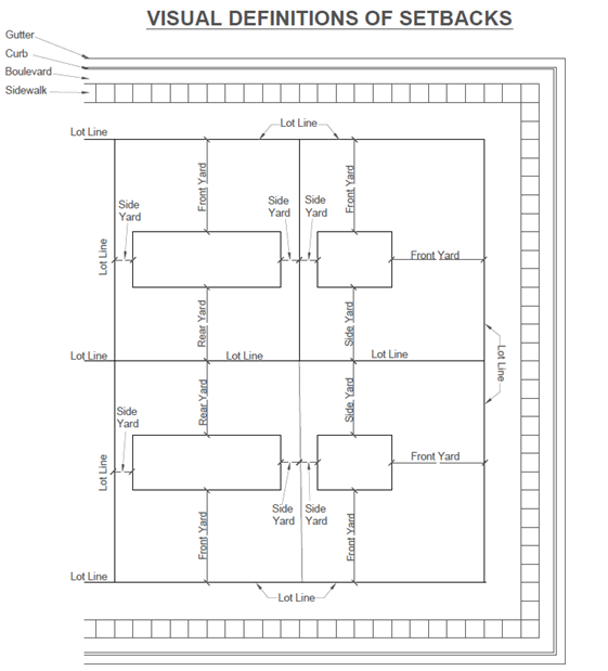
Shopping Centers: A grouping of three (3) or more retail businesses or service uses on a single site of more than five (5) acres but less than ten (10) acres with common parking facilities.
Short-Term Rental: Any rental of a dwelling unit that is for a time period less than thirty (30) days. Requires that there will be an owner, manager or owner’s agent available in Madison County, Idaho. (Includes Bed and Breakfast and Boarding House as categories of short term rentals.) (See subsection 3.02.160.)
Sight Triangle: The sight triangle applies to corner lots on intersecting streets. The triangle of land formed on any corner lot by drawing a line between points on the lot lines which are thirty (30’) feet from the intersection of such lot lines shall be free from any sight obscuring structure or obstruction except as permitted. The sight triangle for private driveways and alleys is fifteen (15') feet from property line. Trees in such triangles shall be trimmed to at least ten feet (10’) above the center-line grades of the intersection streets. Shrubs, fences, and walls shall not be higher than three (3’) feet above the center-line grades of the intersecting streets. The purpose of the sight triangle is to insure visibility and safety in the zones which require buildings to be set back from the property line.
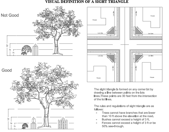
Amended by Ord. 1308 - Rentals - August 2023 on 2/21/2024
Amended by Ord. 1308 Complete Ordinance on 2/21/2024
Amended by Ord. Ord 1320 Fencing Dec 2023 on 9/18/2024
Amended by Ord. Ord 1337 Landscaping March 2025 on 10/1/2025
Sign: Means for identifying and conveying messages visually for businesses and individuals. (See section 3.5.)
.
- Accessory On Premise Sign: A sign, separate from the sign that identifies the business, that advertises brands or products available at the business.
- Blade Sign: A blade sign is a type of sign mounted on a building for the purpose of pedestrian traffic.
- Blanketing: The partial or complete obstruction of view of the face of one sign by another sign.
- Canopy Sign: A sign which is attached or affixed to a canopy or marquee.
- Changeable Copy Panel (Reader board) Sign: A sign with the capability of content change by means of manual or remote input.
- Construction Sign: Any sign which warns people of construction or demolition for a project or which describes the project, builder, architect or others involved in the project.
- Directional Sign, Private: Any sign which serves to designate direction or location, including directories, private parking signs, drive-thru signs, exit and entrance signs, etc.
- Directional Sign, Public: A sign provided and managed by the City or other jurisdiction that designates direction or location, or serves as wayfinding for public services or sites.
- Freestanding, Detached, Monument, Pole, or Ground Signs: A sign which is wholly supported by columns or other vertical supports in or on the ground (not part of the building structure).
- Illuminated Sign: A sign which uses a source of light for illumination.
- Off-Premise Sign: Any sign used for the purpose of displaying, advertising, identifying or directing attention to a business, service, activity or place including products or services sold or offered for sale on premise other than on the premises where such sign is displayed.
- Plaza Sign: A sign that identifies the name of a business complex (i.e. a plaza, strip mall or professional building) as well as advertises individual tenants located within.
- Portable Sign: A sign that is not affixed to the ground or another structure.
- Real Estate Sign: Any temporary sign advertising the sale, lease, or rental of the property or premises on which it is located.
- Sign Area: The area comprising the message portion of a sign, not including the supporting structure.
- Supergraphics Sign: Any abstract mosaic, mural, painting, or graphic art technique or any combination thereof.
- Temporary Sign: A sign which is intended to be displayed for no more than sixty (60) days consecutively and is not permanently affixed.
- Wall Sign: A sign affixed parallel to the plane of the face of the building facade.
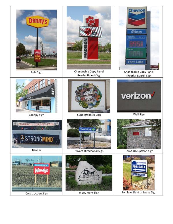
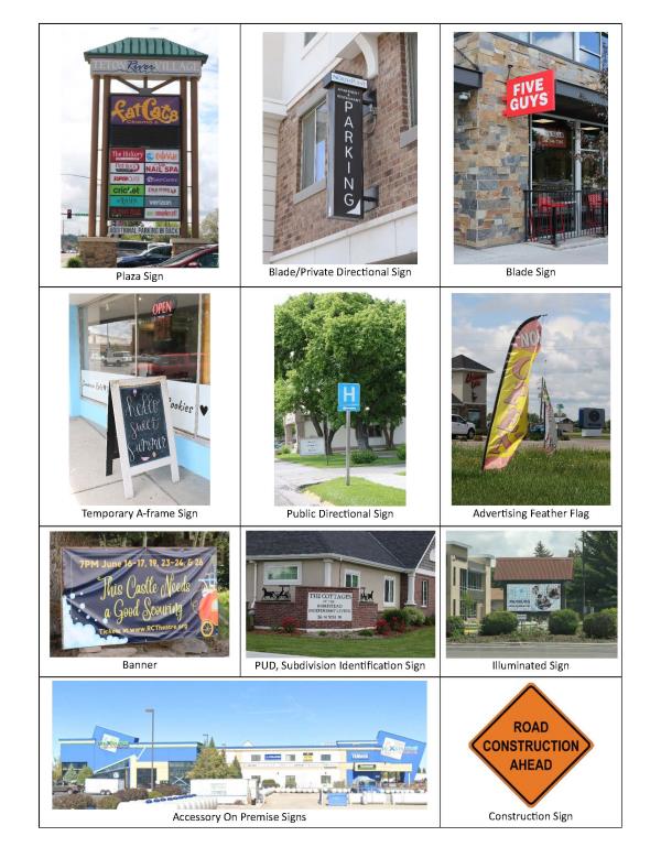
Single-family Dwelling: (see Dwelling, Single-family)
Skybridge: An enclosed, elevated bridge extending from building face to building face that spans a public street, public alley, or is located within private property and provides an uninhibited pedestrian walkway.
Stand: the area reserved for the placement of a manufactured home.
Standard Drawings and Specifications: Standard drawings and specifications are defined as the Rexburg Engineering Department Standards Specifications and Drawings as adopted by the City of Rexburg. (See City Engineering Standards.)
Start of Construction: Includes substantial improvement, and means the date the building permit was issued provided the actual start of construction, repair, reconstruction, placement or other improvement was within one-hundred-eighty (180) days of the permit date. The actual start means either the first placement of permanent construction of a structure on a site or the placement of a manufactured home on a permanent foundation.
Stick Built: A building constructed at the location where it is to be used, not intended or designed to be moved easily.
Story: That portion of a building included between the surface of any floor and the surface of the floor next above it, or if there be no floor above it, the space between such floor and the ceiling above it. A basement shall be counted as a story if its ceiling is over six (6’) feet above the average level of the finished ground surface adjoining the exterior walls of such story, or if it is used for business or dwelling purposes.
Street: A public or private thoroughfare used, or intended to be used for passage or travel by motor vehicles. Driveways are not included. Streets are further classified by the functions they perform.
- Alley Street: A public service way used to provide secondary vehicular access to properties otherwise abutting upon a street.
- Arterial Street: Roads conveying traffic from between major activity centers within the community and traffic through the City. Efficient movement is the primary function of arterial roads. Private and front access should be controlled and limited to high volume generators of vehicle trips.
- Collector Street: Streets that conduct and distribute traffic between other residential streets of lower-order and higher-order streets or major activity centers. This is the highest-order of a street appropriate to a residential neighborhood and residential frontage along it should be prohibited or severely restricted.
- Cul-de-sac Street: A short local street having one end permanently terminated in a vehicular turnaround with a length of no greater than six-hundred (600’) feet.
- Frontage Street: A minor street parallel and adjacent to an arterial route and intercepts local streets and controls access to an arterial route.
- Minor Residential Street: A minor street with both terminal points on the same street or origin that serves no more than fifty (50) single-family lots on one (1) street.
- Residential Access Streets or Local Streets: A street with the sole purpose of providing frontage for service and access to private lots. These streets carry only traffic having either destination or origin on the street itself. The elimination of through traffic and the geometric design of the street are means to promote safety and to create a desirable residential neighborhood.
- Rural Residential Street: A minor street that serves a rural residential subdivision that does not require curb and gutter, but may require a concrete edging strip.
Structure: A walled and roofed building including a gas or liquid storage tank that is principally above ground.
Subdivider: An individual, firm, corporation, partnership, association, syndication, trust, or other legal entity having sufficient proprietary rights in the property to represent the owner, that submits the required subdivision application and initiates proceeding for the subdivision of land in accordance with applicable regulations.
Subdivision: The division of any lot, tract, or parcel of land into three (3) or more parts, for the purposes of transfer of ownership or development and the dedication of a public street and the addition to, or creation of a cemetery.
Substantial Damage: Damage of any origin sustained by a structure whereby the cost of restoring the structure to its before-damaged condition would equal or exceed fifty (50%) percent of its market value before the damage occurred.
Substantial Improvement: Occurs when the first alteration of any wall, ceiling, floor, or other structural part of the building commences, whether or not that alteration affects the external dimensions of the structure. Any repair, reconstruction, or improvement of a structure, the cost of which equals or exceeds fifty (50%) percent of the market value of the structure either:
- Before the improvement or repair is started, or
- If the structure has been damaged and is being restored before the damage occurred.
The term does not, however, include either:
- Any project for improvement of a structure to comply with existing state or local health, sanitary, or safety code specifications which are solely necessary to assure saving living conditions, or
- Any alteration of a structure listed on the National Register of Historic Places or a State Inventory of Historic Places.
Surveyor: Any person who is registered and certified in the State of Idaho to engage in the practice of land surveying.
Amended by Ord. 1248 on 2/17/2021
Amended by Ord. 1298 Manufactured - April 2023 on 6/7/2023
Amended by Ord. Ord 1340 Skybridges September 2025 on 11/18/2025
Temporary Use: A prospective use, intended for a limited duration, generally six (6) months or less, to be located in a zoning district not permitting such use and not continuing such use or building. Tower: Any structure that is designed and constructed primarily for the purpose of supporting one or more antennas for telephone, radio, and similar communication purposes, including self-supporting lattice towers, guyed towers, or monopole towers. The term includes radio and television transmission towers, microwave towers, common-carrier towers, cellular telephone towers, alternative tower structures, and the like. The term includes the structure and any support thereto. This term excludes those used exclusively for dispatch communications. Town Homes: (See Dwellings, Single-family, Attached.) Truck Terminal: Land buildings used as a relay station for the transfer of a load from one (1) vehicle to another or one (1) party to another. The terminal cannot be used for permanent or long-term accessory storage for principal land uses at other locations. The terminal facility may include storage areas for trucks and buildings or areas for the repair of trucks associated with the terminal. Twin Home: (See Dwellings, Single-family Attached) Unsuitable Land: Land which the Commission determines to be unsuitable for subdivision because of periodic flooding, poor drainage, excessively steep slopes or other features likely to be harmful to the safety and general health and welfare of the future residents. Unsuitable land shall not be subdivided unless adequate methods are utilized to overcome these conditions.
Usable Lot Area: That portion of a lot usable for or adaptable to the normal uses made of the property, excluding any areas which may be covered by water, excessively steep, or included in certain types of easements. Utilities: Installation or facilities, underground or overhead, furnished for use by the public, including but not limited to electricity, gas, steam, communications, water, television, drainage, irrigation, sewage disposal, or flood control, whether owned and operated by any person, firm, corporation, municipal department, or board duly authorized by state or municipal regulations. Utility or utilities as used herein may also refer to such persons, firms, corporations, departments, or boards, as applicable herein. Utility Yard: Any electrical, gas, steam, communications, water, television, drainage, irrigation, sewage disposal or flood control yard that has equipment exposed. Yards are required to be screened. If equipment is underground, in a vault or above ground in a building it need not be screened.
Vacant properties: Vacant properties for this purpose are defined as those that have been vacant for over a substantial number of years or those that have had buildings or improvements removed and have been vacant for a substantial number of years.
Variance: A modification of the requirements of this Ordinance for lot size, lot coverage, width, depth, front yard, side yard, rear yard, setbacks, parking space, height of buildings, or other ordinance provisions affecting the size or shape of a structure, the placement of the structure upon lots, or the size of the lot. A variance does not include a change of land use. (See Idaho Code 67-6516.) Vending Location: Stalls at a specific location designated for the placement of a mobile vendor.
Vendor: Any person, including an employee or agent of a group of individuals, partnership, or corporation, who sells or offers to take orders or sell food, beverages, goods, or merchandise from a mobile vending cart, mobile vending vehicle, or mobile vending trailer, or any other type of conveyance or from his or her person. The word vendor shall include the words "hauler', "huckster" and "peddler".
- Mobile Vendor: A business exhibiting goods or services from a mobile vending vehicle, mobile vending trailer, or mobile structure.
- Mobile Vendor Locations.
- Mobile Court Vendor: A mobile vendor on private property.
- Pushcart Vendor: A daily mobile vendor, vending from a mobile pushcart to persons on the designated public right-of-way.
- Street Vendor: A daily mobile vendor, in a designated parallel parking stall selling only to persons or pedestrians on the sidewalk.
- Mobile Vendor Operation Times.
- Daily Vendor: A business exhibiting goods or services within the City of Rexburg from a temporary or mobile structure or vehicle for not more than eighteen (18) hours in twenty-four (24) hours on any one site.
- Special Events. Hours of operation may be amended with approval of a Public Gathering Permit allowing setup and take-down to occur one hour before and after the stated times.
- Private Property Vendor: A business exhibiting goods or services within the City of Rexburg from a temporary or mobile structure or vehicle, or in a similar manner on private property for greater than fourteen (14) days in a calendar year.
- Temporary Vendor: A business exhibiting goods or services within the City of Rexburg from a temporary or mobile structure or vehicle, or in a similar manner for less than fourteen (14) days in a calendar year.
- Daily Vendor: A business exhibiting goods or services within the City of Rexburg from a temporary or mobile structure or vehicle for not more than eighteen (18) hours in twenty-four (24) hours on any one site.
- Mobile Vendor Locations.
Vicinity Map: A small scale map showing the location of a tract of land in relation to a larger area. Warehousing and Distribution: A use engaged in storage, wholesale, and distribution of manufactured products, supplies and equipment, but excluding bulk storage of materials that are inflammable or explosive or that create hazardous or commonly recognized offensive conditions. Yard: Any open space located on the same lot with a building, unoccupied and unobstructed from the ground up, except for accessory buildings, or such uses as provided by this Development Code. The minimum depth or width of a yard shall consist of the horizontal distance between the lot line and the line of the main building unless otherwise noted in the Development Code.
- Front Yard: A yard extending along the full width of a front lot line between side lot lines and from the front lot line to the front building line in depth.
- Rear Yard: A yard extending the full width of the lot and lying between the rear lot line and the nearest line of the building. Rear-yard depth shall be measured at right angles to the rear line of the lot.
- Side Yard: A yard lying between the side line of the lot and the nearest line of the building and extending from the front yard to the rear yard. Side yard width shall be measured at right angles to the side lines of the lot.
Zone: A portion of the territory of the City, exclusive of streets, alley, and other public ways, within which certain uses of land, premises, and buildings are not permitted and with which certain yards and open spaces are required and certain heights are established for buildings.
3.2 ZONING STANDARDS
3.3 NONCONFORMING USES AND BUILDINGS IN ALL ZONES
3.4 PARKING STANDARDS FOR ALL ZONES
3.5 SIGN STANDARDS FOR ALL ZONES
3.6 LIGHTING STANDARDS
3.7 CELL TOWERS
3.8 PERMITTED USES
3.9 SKYBRIDGES
Recorded by Ord. 884 Established the Historic Preservation Commission to manage local historic properties on 10/2/2002
Amended by Ord. 1159 Amended Ord. 1115; Required a Conditional Use Permit for all Dormitory Housing in all Applicable Zones and Amended the Parking Spaces Required for Dormitory on 5/3/2017
3.01.020 Zoning Districts
3.01.030 Determination Of District Boundaries
3.01.040 Lots Divided By District Boundaries
Recorded by Ord. 47 Divides City into 3 Zones by Wards on 2/14/1903
Recorded by Ord. 390 Establishes 5 Zones determined by Use: A, B, C, D, E on 3/16/1955
Recorded by Ord. 478 Reorganized 5 Zones: 3 Residential, Commercial and Industrial and Zoning Map created on 5/3/1968
The boundaries and zoning classifications of districts are shown on the map entitled “Rexburg Zoning Map,” which map and all information shown thereon may from time to time be modified, and are by reference thereto made a part of this Ordinance.
The City may be divided into the following zoning districts, the boundaries and extent of which shall be shown on the official Rexburg Zoning Map by the City of Rexburg Staff:
Residential Zones (a) Rural Residential 1 (RR1) (b) Rural Residential 2 (RR2) (c) Low Density Residential 1 (LDR1) (d) Low Density Residential 2 (LDR2) (e) Low Density Residential 3 (LDR3) (f) Medium Density Residential 1 (MDR1) (g) Medium Density Residential 2 (MDR2) (h) High Density Residential 1 (HDR1) (i) High Density Residential 2 (HDR2)
Combined Use Zones (j) Mixed Use (MU) (k) Transitional Agriculture (TAG)
Commercial District Zones (l) Community Business Center (CBC) (m) Regional Business Center (RBC)
Highway Business District Zones (n) Light Industrial District (LI) (o) Heavy Industrial District (HI)
Other Zones (p) Open Space (OS) (q) Public Facilities Zone (PF) (r) University District (UD)
(s) Residential Business District (RBD)
(t) Project Redevelopment Option (PRO)
Unless otherwise defined on the Rexburg Zoning Map, district boundaries are the quarter lines or center lines of ten (10) acre blocks; platted lot lines; property lines; the center lines of streets, alleys, or railroad right-of-way (or such lines extended); government survey lines; municipal limit lines; or the center lines of streams.
If a parcel or lot is divided by district boundaries, the requirements of the most restrictive district shall apply to the property.
3.02.020 Sale Of Lots Below Minimum Space Requirements
3.02.030 Yard Space For One Principal Building
3.02.040 Access To Public Street Required
3.02.050 Clear View Of Intersecting Streets; Sight Triangle
3.02.060 Accessory
3.02.070 Transitional Development Standards
3.02.080 Exception To Setback Requirements
3.02.90 Screening And Landscaping
3.02.100 Fences
3.02.110 Trash Storage
3.02.120 Project Plan Approval
3.02.130 Addressing
3.02.140 Dormitory
3.02.160 Sidewalks
3.02.170 Flag Poles
3.02.180 Special Flood Hazard Development
3.02.190 Fire Standards
3.02.200 Code Standards
Amended by Ord. 778 Amended Ord. 725; Add "Separate Parking Lots" as CUP in each of designated districts; For Corner Lots, No Rear Yard Setback, 2 Side Yard Setbacks instead on 12/6/1995
Repealed & Reenacted by Ord. 1200 Replaced Ord. 1115 with Amendments; Consolidated Parking and Fencing Standards; Clarified Sign Calculations, Repeated Standards placed in Standards sections on 2/6/2019
The regulations of this chapter qualify or supplement the regulation within zones appearing elsewhere in this Ordinance.
- A parcel of land which has less than the minimum width or area requirements for the zone in which it is located shall not be separated from a larger parcel of land for the purpose of immediate or future building or development as a lot, easement, or for the purpose of sale, unless easements are provided and reviewed by the Zoning Administrator and the City Attorney. If an existing lot or parcel is substandard in size by the current zoning ordinance, a portion of that lot or parcel may not be sold or be allowed to be used by another entity by easement.
- Projects that contain multiple buildings that meet code compliance as one property may be divided into separate lots through a Planned Unit Development (PUD) process, a Condominium Plat, or by providing the necessary recorded easements to address substandard lot area, lot width and setbacks.
No two (2) principal buildings may claim the same, or portions of the same, lot area or width or required yard for the purposes of compliance with this Ordinance.
- All principal buildings shall be served by a public street. Access to a principal building only from an alley is prohibited.
- All principal buildings must have adequate access and frontage for police, fire, and emergency services.
- The City of Rexburg right of way width is dictated by City Engineering Standards.
To ensure reasonable visibility and safety in residential zones and other zones which require buildings to be set back from the lot line, the triangle of land formed on any corner lot by drawing a line between points on the lot lines which are thirty feet (30’) from the intersection, or fifteen (15') feet for driveways and alleyways, of such lot lines shall be free from any sight obscuring structure or obstruction except as permitted below. (See Sight Triangle definition.)
- Trees in such triangles shall be trimmed to at least ten (10’) feet above the centerline grades of the intersecting streets.
- Shrubs, fences, and walls shall not be higher than three (3’) feet above the centerline grades of the intersecting streets.
Recorded by Ord. 358 Section 11 Establish Sight Triangle on 2/19/1947
Amended by Ord. 1298 Chapter 3 Standards for All Zones - April 2023 on 6/7/2023
Amended by Ord. Ord 1320 Fencing Dec 2023 on 9/18/2024
Accessory structures are permitted in all zones, provided they are incidental to, and do not substantially alter the character of the permitted principal use or structure. Such permitted accessory uses and structures include, but are not limited to the following: detached garages, carports, equipment storage buildings, supply storage buildings, and temporary construction storage and offices.
Accessory Building Requirements.
- All Accessory buildings shall:
- Comply with all lot configuration requirements in the existing zone.
- Comply with the Building Codes adopted by the City of Rexburg.
- Be an accessory to an existing primary structure or residence.
- Have facilities for the discharge of all roof drainage on to the lot or parcel on which it is erected.
- Residential Accessory Buildings.
- Require a building permit if more than two hundred (200) square feet.
- Front Yard. May not be placed in the front yard.
- Side Setback. Must meet the same side setback requirements as a principal building if larger than five hundred (500) square feet or taller than ten (10') feet in height.
- If between two hundred (200 sq ft) square feet and five hundred (500 sq ft) square feet, a six (6') feet side setback is required.
- If less than two hundred (200) square feet, may be placed on the property line.
- Rear Setback. Must be a minimum of five (5') feet from property line if larger than two hundred (200) square feet, unless the accessory building is a garage with doors opening into a City-owned alley. Such garages shall be a minimum of fifteen (15') feet from the alley.
- If less than two hundred (200) square feet, may be placed on the property line.
- If less than two hundred (200) square feet, may be placed on the property line.
- Commercial & Industrial Accessory Buildings.
- Require a building permit if larger than one-hundred-twenty (120) square feet.
- Front Yard. May not be placed in the front yard.
- Side Setback. Must meet the same side setback requirements as a principal building if larger than one-hundred-twenty (120) square feet or taller than ten (10’) feet in height.
- If less than one-hundred-twenty (120) square feet, must be a minimum of five (5’) feet from property line.
- Rear Setback. Must meet the same rear setback requirements as a principal building.
- Exception: University District (UD)
Amended by Ord. 983 Amended Ord. 926 Accessory Buildings drainage on 5/2/2007
Amended by Ord. 1055 Amended Ord. 1026; Required Accessory Buildings larger than 200 sq.ft. or taller than 10' to meet the Same Side Yard Requirements as Principal Buildings on 11/3/2010
Amended by Ord. 1298 Chapter 3 Standards for All Zones - April 2023 on 6/7/2023
Amended by Ord. 1308 - Accessory Buildings - September 2023 on 2/21/2024
Amended by Ord. Ord 1337 Accessory Side Setbacks May 2025 on 10/1/2025
- Transitional Development Standards. Where a lot in any business, commercial, manufacturing, industrial, or public facilities zone borders a residential zone or use, the standards of the residential zone shall apply in regards to setbacks and building heights.
- No drainage shall be diverted into said public right-of-way. Run-off must be contained on own lot.
Recorded by Ord. 358 Section 11 Building Setbacks on 2/19/1947
Amended by Ord. 388 Amending Building Setbacks on 8/18/1954
Recorded by Ord. 390 Section VIII & IX. Exception to Building Height and Setbacks for certain buildings on 3/16/1955
Amended by Ord. 413 Distance from eves of building and property line on 1/15/1958
Amended by Ord. 1157 Amended Ord. 1115; Runoff contained on your own lot on 3/1/2017
- When fifty (50%) percent or more of the lots on the same side of the street have been built, all buildings erected, established, or rebuilt shall be in conformity with the averaged setback of such buildings.
- Parking and maneuvering areas are not included in the calculation of this exception nor shall these areas be granted an exception to the required front yard setbacks.
- The following structures may be erected on or projected into any required setback or right-of-way:
- Fences and walls in conformance with the Rexburg City Code and Ordinances.
- Landscape elements including trees, shrubs, agricultural crops and other plants.
- Necessary appurtenances for utility.
- Permitted Building Projections with Conditions. The structures listed below may project into a minimum front or rear yard not more than four (4’) feet, and into a minimum side yard not more than two (2’) feet.
- Cornices, eaves, belt courses, sills, buttresses, or other similar architectural features.
- Stairways, balconies, door stoops, fire escapes, fireplaces, awnings and planter boxes or other similar structures.
- Provided they do not exceed thirty (30”) inches in height from the natural grade.
- Provided they are not wider than eight (8’) feet and are generally parallel to the wall of which they are a part.
- Uncovered steps or a deck may not extend into the front setback more than one-third of the required setback.
- Underground Structures. Underground structures may be projected into any required setback if the structure is covered by landscaping or grass and does not raise the grade of the yard by more than two (2’) feet.
- Public Utility Easements. Building structures shall not encroach in Public Utility Easements.
- Carports or Loading Dock. Carports and loading docks are allowed in a side yard or rear yard, provided that such a structure is not more than one (1) story in height and twenty-four (24’) feet in length and is entirely open on at least three (3) sides, except for necessary supporting columns and customary architectural features.
Recorded by Ord. 390 Section IX.d. Unobstructed Projections on 3/16/1955
Amended by Ord. 802 Amend Ord. 725; Section A (see above) on 4/15/1998
Amended by Ord. 855 Repealed Ord. 478 and Ord. 685; Amended Ord. 725; Repeated Section "A" (see above) on 6/6/2001
Amended by Ord. 1132 Amended Ord. 1115; Cornices, eaves belt courses, sills, buttresses, "foundation extension under 3' in height" or other similar architectural features; Fireplace structures, bays "and other similar structures" provided they are not wider than 8' and part of the wall of which they are a part. on 6/3/2015
Amended by Ord. 1188 Amended Ord. 1115 50% or more of lots on same side of street in Residential zones, built in conformity with the average setback of such buildings; Sidewalks to be placed as per current City Engineering Standards. on 7/18/2018
Amended by Ord. 1308 - Lot Config/Density/Setbacks - August 2023 on 2/21/2024
The following are minimum standards. Additional landscaping elements may be allowed by the Zoning Administrator or Designee. Screening, landscaping, and fences within the City shall be constructed and maintained in conformance with the following standards:
- Landscaping. Landscaping and all applicable irrigation systems shall be maintained by the property owner, or in cases of a right-of-way the adjacent property owner, as in their original purpose.
- Landscape Strip. In all zones, the area between the curb and gutter and the sidewalk is to be landscaped with a pervious surface, by the adjacent property owner.
- Sight Triangle. The sight triangle must be clear of obstructions. See Sight Triangle.
- Columnar and Evergreen trees are not allowed in the landscape strip.
- Overhead Powerlines. In the event of overhead powerlines, alternative landscaping may be approved by the Zoning Administrator.
- Projects within Medium Density Residential (MDR1 & MDR2), High Density Residential (HDR1 & HDR2), Mixed Use (MU), Community Business Center (CBC), Regional Business Center (RBC), University District (UD) or Industrial (LI & HI) zones shall include in the landscape strip trees and shrubs that meet the following criteria:
- Tree and Shrub Requirements.
- Deciduous trees with a minimum caliper of two (2") inches and a maximum spacing of thirty (30') feet.
- As trees mature, they shall be trimmed to at least ten (10’) feet above the curb.
- A minimum of five (5), five (5) gallon containers of shrubs within every thirty (30’) foot section.
- Tree and Shrub Requirements.
- Parking Areas. (See subsection 3.04.060.A.)
- Projects within Medium Density Residential (MDR1 & MDR2), High Density Residential (HDR1 & HDR2), Mixed Use (MU), Community Business Center (CBC), Regional Business Center (RBC), University District (UD) or Industrial (LI & HI) zones that are adjacent to a lower density residential zone, shall have a ten (10’) feet wide landscaped buffer on the abutting property line, where the buffer is planted with a combination of trees, shrubs, and ground cover and/or a suitable fence of sufficient height and density to buffer the two parcels. At a minimum, two (2”) inch caliper trees with a maximum spacing of thirty (30’) feet and five (5), five (5) gallon containers of shrubs between trees are required within the buffer.
- Highway 20 Corridor. All development adjacent to the Highway 20 right-of-way must submit a Landscape Plan to the Zoning Administrator or designee to be approved for design prior to obtaining a building permit.
- Commercial/Industrial Standards. Buildings adjacent to the Highway 20 right-of-way shall provide a buffer at least ten (10') feet in width consisting of two (2”) inch caliper trees with an average spacing of fifty (50’) feet and eight (8), five (5) gallon containers of shrubs.
- Front Yard Display. Commercial uses with a display facing the Highway 20 right-of-way may use alternate landscaping with the approval of the Zoning Administrator.
- Front Yard Display. Commercial uses with a display facing the Highway 20 right-of-way may use alternate landscaping with the approval of the Zoning Administrator.
- Setback. A minimum setback of twenty-five (25’) feet is required from any building to the Highway 20 right-of-way or a one-to-one setback to height requirement, whichever is greater.
- Commercial/Industrial Standards. Buildings adjacent to the Highway 20 right-of-way shall provide a buffer at least ten (10') feet in width consisting of two (2”) inch caliper trees with an average spacing of fifty (50’) feet and eight (8), five (5) gallon containers of shrubs.
- Open Storage Area. Open storage area in commercial and industrial zones shall be screened from view of the streets by structures or by a landscaped buffer at least ten (10') feet in width and planted with a combination of trees, shrubs, and ground cover and/or a suitable fence of sufficient height and density to obstruct the view of the storage area.
- No front yard storage. Open storage shall not be located within a required front yard.
- Front Yard Display. Commercial uses with a front yard display may use alternate landscaping with the approval of the Zoning Administrator.
- Utility yards. Utility yards in zones other than Industrial or adjacent to any residential zone or commercial zone are required to be screened with a seven (7') foot tall decorative masonry wall or privacy fence as approved by the Zoning Administrator.
- Setbacks.
- Front Setback. The wall or fence must be set back at least ten (10’) feet from the front property line. The area between the right-of-way and the wall or fence shall consist of pervious landscaping and be planted with one two (2”) inch caliper deciduous tree and five (5), five (5) gallon containers of shrubs within every thirty (30’) foot section.
- Side and Rear Setbacks. The fence may be on the side and/or rear property line.
- Water Tanks. Water tanks are not required to be screened.
- Pumps and other equipment associated with water tanks will be in below-grade vaults, in buildings or shall be screened as utility yards.
- Setbacks.
Amended by Ord. 753 Amended Ord. 725 Sect.4.7.A.1 & 2 and 4.8A Commercial or Industrial use adjoins residential zone or Comprehensive Plan designation, along abutting property line a yard equal in width to residential zone. Landscaping requirements. on 10/20/1993
Repealed & Reenacted by Ord. 1115 Repealed Ord. 548, 642, 658, 915, 1021, 1027, 1095 and 1026; Development Code; Added Highway 20 Corridor Site Plan Requirements on 6/25/2014
Amended by Ord. 1181 Amended Ord. 1181; All development adjacent to Highway 20 right-of-way must submit a Site Plan meeting city requirements prior to obtaining a Building Permit. on 2/21/2018
Amended by Ord. 1188 Amended Ord. 1115; Utility Yard Definition and Requirements in zones other than Industrial or adjacent to any Residential or Commercial Zone. on 7/18/2018
Amended by Ord. 1237 on 11/4/2020
Amended by Ord. 1251 on 2/17/2021
Amended by Ord. 1298 Chapter 3 Standards for All Zones - April 2023 on 6/7/2023
Amended by Ord. 1308 - Lot Config/Density/Setbacks - August 2023 on 2/21/2024
Amended by Ord. Ord 1337 Landscaping March 2025 on 10/1/2025
No fence, wall, hedge or other material serving as a fence shall create an obstruction of vision within sight triangles. (See subsection 3.02.050)
- Application Required. All fencing must obtain administrative review and approval by the Planning & Zoning Administrator or designee.
- Building Permit. Fences over seven (7') feet in height must obtain a building permit.
- Floodplain. No fence shall be constructed in the floodplain without administrative approval.
- Barbed Wire/Electric. Barbed wire and electric fences shall only be allowed for agricultural use in Transitional Agriculture (TAG).
- Security Fences. Barbed or razor wire located at the top of security fences requires administrative approval.
- Sight Triangle. Fencing shall not create an obstruction of vision and must observe all sight triangle requirements. (See Sight Triangle definition and subsection 3.02.050).
- Utilities. Fencing shall not obstruct access to utility apparatuses (fire hydrants, utility boxes, transformers, fiber hand holes, etc.) and must adhere to the utility company clearance requirements.
- Fence Height. The height of any fence, wall, or sight-obscuring objects within fifteen (15’) feet of the right-of-way shall be a maximum of three (3’) feet in height measured from the natural grade of the property on which it is located.
- Exception for Corner or Double Frontage Lots. When a parcel is a Corner Lot or a Double Frontage Lot and a written prohibition of street access for the entirety of the block exists, a fence greater than three (3') feet can be located adjacent to the sidewalk, outside of the site triangle.
- Rear Yard. In a rear yard, walls and fences may be between three and six feet (3'-6'). A fence may be built along the property line in a rear yard.
- Dog Runs. Dog runs shall be placed in rear yards only and shall be a minimum of ten (10') feet from another residence.
- Dog Runs. Dog runs shall be placed in rear yards only and shall be a minimum of ten (10') feet from another residence.
- Exception for Corner or Double Frontage Lots. When a parcel is a Corner Lot or a Double Frontage Lot and a written prohibition of street access for the entirety of the block exists, a fence greater than three (3') feet can be located adjacent to the sidewalk, outside of the site triangle.
- Maintenance. Fences shall be maintained in a good state of repair.
- Fence Adjacent to Public Sidewalk or Bicycle Path.
- Pedestrian Gates. Pedestrian access gates shall swing inward when adjacent to a public sidewalk or bicycle path. (See subsection 3.02.170.)
- Commercial/Industrial Adjacent to Residential. A vinyl or masonry fence of at least six (6’) feet in height shall be erected along all property lines which lie adjacent to a residential zone or use, except front yards, where the height of the fence shall not exceed thirty-six (36”) inches within fifteen (15’) feet of the right-of-way.
- Exception. Modifications may be requested if there is a mutual agreement between the adjacent property owners of both zones. Administrator approval is required.
- Exceptions.
- The provisions of this section shall not apply to sport containment fences as approved by the Zoning Administrator.
- Schools, Churches, Universities, Colleges, Hospitals, Nursing Homes, City and County. The height, location and placement of fences by the foregoing entities may be altered, subject to prior written approval of the Zoning Administrator. However, sight triangles at any intersection must be maintained pursuant to Section 3.02.050. of this Ordinance. (See Sight Triangle definition.)
- Retaining Walls. Where a retaining wall protects a cut below or a fill above the natural grade and is located on the line separating lots or properties, such retaining wall may be topped by a fence, wall or hedge of the same height that would otherwise be permitted at the location if no retaining wall existed only after approval by the Zoning Administrator.
- All other exceptions must obtain administrative approval.
The following illustrations are for demonstration only and do not represent any existing lots.
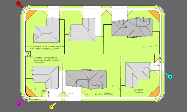
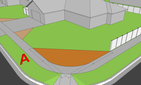
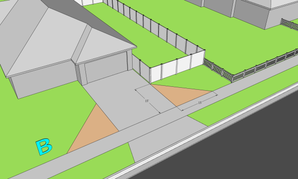
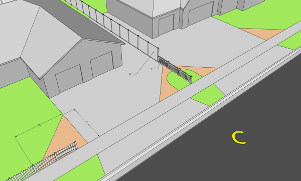
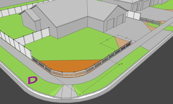
Recorded by Ord. 390 Section VIII. c-d. Fence Height and Location on 3/16/1955
Amended by Ord. 778 Amended Ord. 725; Establishing F (see above); New Section 4.A.8 HBD, CBD, NCD and I zones no fence higher than 36" extend beyond the line of existing builidngs, No setback requirements for a building, then no setback requirements for a fence and Setback bordering a street, fence no taller than 36" within the front setback from the property line of the building. on 12/6/1995
Amended by Ord. 802 Amend Fencing Height and 50% see through fence rules on 4/15/1998
Reenacted by Ord. 1095 Fencing height readopted on 12/19/2012
Amended by Ord. 1095 Amended Ord. 1026; Fencing within 15' of public right-of-way shall be 3'; Fences allowed 3'-6' if constructed out of rigid materials that are 50% see through per lineal foot. Fences no taller than 8' unless approved by P&Z Commission. on 12/19/2012
Amended by Ord. 1279 on 4/6/2022
Amended by Ord. 1298 Chapter 3 Standards for All Zones - April 2023 on 6/7/2023
Amended by Ord. Ord 1320 Fencing Dec 2023 on 9/18/2024
Areas for outdoor storage, truck parking, trash collection or compaction, loading, or other such uses shall not be visible from public or private rights-of-way.
- Trash shall be stored in screened areas.
- No trash containment device shall be placed in such a location as to be visible from the public right-of-way unless in preparation for pickup, and under no circumstance for any period greater than twenty-four (24) hours prior to and subsequent to the regularly scheduled pickup for trash.
- Materials and location of the screened areas shall be reviewed and approved by the Zoning Administrator or designee prior to installation.
- No areas for outdoor storage, trash collection or compaction, loading, or other such uses shall be located within the required setback.
- Screened enclosures shall be allowed in the front yard setback with the Public Works Director approval.
Recorded by Ord. 392 Provide control, regulation, collection, removal and disposal of all garbage, waste, refuse and rubbish and established charges for those services on 6/1/1955
Amended by Ord. 426 Amended Sect.IX of Ord. 392; Adjusted garbage pick-up rates on 8/2/1961
Repealed & Reenacted by Ord. 559 Providing for control of garbage, waste, refuse removal; Amended garbage pick-up schedule and fees; Repealed Ord. 392 & Ord. 426 on 2/19/1975
Amended by Ord. 599 Amended Sect.XXII, XXIV and XXVI of Ord. 559; Amends Fee Schedule, Violations are a Misdemeanor on 1/17/1979
Amended by Ord. 625 Amend Ord. 599 Monthly Charges for Garbage Removal on 9/3/1980
Amended by Ord. 635 Amended Ord. 625 Sect.1 for Monthly Charges for Garbage Removal on 9/16/1981
Amended by Ord. 640 Amended Ord. 599 Sect.1 Monthly Garbage Removal Charges for Non-Residential on 10/7/1981
Amended by Ord. 650 Amend Ord. 635 Sect.1 Monthly Charges for Garbage Removal for Residential; Amend Ord. 640 Sect.1 for Non-Residential Charges on 2/17/1982
Amended by Ord. 711 Amends Ord. 650 Sect.I, Amends Ord. 650 Sect.II Garbage Removal Monthly Charges for Residential and Non-Residential; Feees to be set by Resolution on 9/19/1990
Recorded by Ord. 765 Prohibits unauthorized deposit of refuse in garbage container belonging to someone else; Defines garbage that is not allowed in any city container; Obstructing dumping of City Garbage Containers; Prohibits disposing solid waste on public or private property; No burning material in container; Frequency of Collection and Charges for Collection Service on 8/2/1994
All projects constructed in any zone must submit, prior to beginning construction:
- An Infrastructure Plan (including a Drainage and Landscape Plan) for review and approval by City of Rexburg Building Department. (See section 10.4.)
- Drainage on to an adjacent lot not owned by applicant is not allowed.
- Commercial Projects. All project plans and engineering specifications in the Community Business Center (CBC) Zone must be prepared and engineered by A/E professionals. These professional engineered plans will be submitted for review and approval from conception by the Development Review Committee.
Amended by Ord. 1248 on 2/17/2021
Amended by Ord. 1298 Chapter 3 Standards for All Zones - April 2023 on 6/7/2023
- All buildings shall have a permanently posted address placed in a position that is plainly legible and visible from the street or road fronting the property.
- Addresses will be assigned by the City of Rexburg.
- Lots, blocks, and/or units shown on a plat may not be representative of the parcel's address.
- Address Markers.
- Numbers shall be a color that is distinct from the background color.
- Street numbers must be a minimum of four (4”) inches high and a minimum stroke width of one-half (0.5”) inch.
- Building numbers shall be twelve (12”) inches in height.
- Font shall be a block type font that is easy to read.
- Driveway Markers. (15.07.250 Address Identification)
- Addresses shall be placed at each driveway entrance and be visible from both directions of travel along the road on which the address is located.
- Multiple Addresses. Where multiple addresses are required at a single driveway, they shall be mounted on a single post and additional signs shall be posted at locations where driveways divide.
- Time Frame. In all cases the address shall be posted at the beginning of construction and maintained thereafter.
- See Sight Triangle.
- See Right-of-Way.
- Addresses shall be placed at each driveway entrance and be visible from both directions of travel along the road on which the address is located.
- Residential Address.
- The assigned address of any City residence must be posted on the structure within ten (10’) feet of the primary entrance door that faces the street side. Said numbers must be readable from the street as determined by City Emergency Services.
- Name and Address. Signs or name plates shall not exceed two (2) square feet in area and display only the name and address of the occupant.
- The assigned address of any City residence must be posted on the structure within ten (10’) feet of the primary entrance door that faces the street side. Said numbers must be readable from the street as determined by City Emergency Services.
- Multi-Family Dwelling Address.
- When individual apartment, condominium, or town house structures within a common complex are designated with separate addresses, individual unit numbers shall be assigned so there is no duplication of unit designations within a building.
- Multiple Floors. The first floor shall be 100 series, second floor 200 series and so on for each successive floor. Basements shall be 10 series if the next higher floor is designated the first floor, or basements shall be designated 100 series if the next level is called the second floor.
- When apartment, condominium, or town house complexes (more than one structure) have been assigned one address, each individual building shall also be assigned a number.
- Building Number. The building number shall be posted in a conspicuous location with the number being a minimum of twelve (12”) inches in height in a contrasting color to the background.
- Unit or Apartment Numbers. Unit or apartment numbers shall then be assigned in the 10, 100, 200, 300, etc. series per floor.
- Commercial. When a building is commercial, these numbers are referred to as commercial “suites” instead of residential “units”.
- Commercial. When a building is commercial, these numbers are referred to as commercial “suites” instead of residential “units”.
Dormitory is subject to Commercial Design Standards in Mixed Use (See section 7.0), but in the High Density Residential and Medium Density Residential zones, the Residential Design Standards apply (See subsection 4.00.050).
- In all zones, all buildings erected, established, or rebuilt shall be required to place sidewalks per the current City Engineering Standards. (See Appendix.B.)
- Exempt in Transitional Agriculture (TAG) and Rural Residential 1 (RR1) zones.
- Mixed Use. Sidewalks parallel to any city street within a Mixed Use (MU) zone shall be a minimum of eight (8') feet wide.
- Sidewalk Access. Projects located within Medium Density Residential (MDR), High Density Residential (HDR) or Mixed Use (MU) zones are required to demonstrate sidewalk access to the BYU-I campus and to the nearest Substantial Commercial Cluster (See definition in Chapter 2).
- Parking Lots.
- Sidewalks. The sidewalk shall be no less than six (6') feet wide where parked vehicles overhang the sidewalk.
- Drainage. Parking lots shall provide adequate drainage which shall not run across or cover a public sidewalk.
- Sidewalks. The sidewalk shall be no less than six (6') feet wide where parked vehicles overhang the sidewalk.
- When a fence is placed adjacent to a public sidewalk in residential zones and no driveway access exists, a one (1') foot landscape strip shall be maintained between the standard sidewalk and the fence.
- Exempt in Mixed Use (MU)
Amended by Ord. 1188 Amended Ord. 1115; In all Residential zones, buildings erected or rebuilt are required to place sidewalks as per City Engineering Standards. on 7/18/2018
Amended by Ord. 1298 Chapter 3 Standards for All Zones - April 2023 on 6/7/2023
Amended by Ord. 1308 - Lot Config/Density/Setbacks - August 2023 on 2/21/2024
Amended by Ord. Ord 1320 Fencing Dec 2023 on 9/18/2024
- Flag poles that serve a non-advertising purpose are permitted, provided they can be erected without creating any safety issues.
- Residential. The flag pole shall not exceed the maximum allowed building height in the residential zone.
- Commercial. The flag pole shall not exceed eighty (80') feet.
- Residential. The flag pole shall not exceed the maximum allowed building height in the residential zone.
The floodplain area is an area of special flood hazard identified by the Federal Insurance Administration in a scientific and engineering report entitled “The Flood Insurance Study for Madison County and its incorporated cities,” dated January 17, 1990, as amended with accompanying Flood Insurance Maps and is hereby adopted by reference and declared to be a part of this ordinance (Ord. 1129).
- Purpose and objectives.
- Purposes. It is the purpose of this Section to promote the public health, safety, and general welfare, and to minimize public and private losses due to flood conditions in specific areas by provisions designed:
- To protect human life and health
- To minimize expenditure of public money and costly flood control projects;
- To minimize the need for rescue and relief efforts associated with flooding and generally undertaken at the expense of the general public;
- To minimize prolonged business interruptions;
- To minimize damage to public facilities and utilities such as water and gas mains, electric, telephone and sewer lines, streets, and bridges located in areas of special flood hazard;
- To help maintain a stable tax base by providing for the sound use and development of areas of special flood hazard so as to minimize future flood blight areas;
- To ensure that potential buyers are notified that property is in an area of special flood hazard; and
- To ensure that those who occupy the area of special flood hazard assume responsibility for their actions.
- Objectives.
- Restrict or prohibit uses which are dangerous to health, safety, and property due to water or erosion hazards, or which result in damaging increases in erosion or in flood heights or velocities.
- Require that uses vulnerable to floods, including facilities which serve such uses, be protected against flood damage at the time of initial construction.
- Control filling, grading, dredging, and other development which may increase flood damage;
- Prevent or regulate the construction of flood barriers which will unnaturally divert flood waters or may increase flood hazards in other areas.
- Purposes. It is the purpose of this Section to promote the public health, safety, and general welfare, and to minimize public and private losses due to flood conditions in specific areas by provisions designed:
- Permit Required. A Building Permit shall be obtained before construction or development begins for all structures with any area of special flood hazard.
- Information Required. Plans in duplicate drawn to scale shall show the nature, location, dimensions, and elevations of the area in question; existing or proposed structures, fill storage of materials, drainage facilities, and the location of the foregoing.
- Elevation in relation to mean sea level, of the lowest floor (including Basement) of all structures;
- Elevation in relation to mean sea level to which any structures has been flood proofed;
- Certification by a registered professional engineer or architect that the flood-proofing methods for any nonresidential structure meet the flood-proofing criteria;
- Description of the extent to which a watercourse will be altered or relocated as a result of proposed development.
- Permit Review. The Building Official shall review the permit submittal for the following:
- To determine the permit requirements of this Ordinance have been satisfied.
- To determine that all necessary permits have been obtained from those Federal, State, or local governmental agencies from which prior approval is required.
- To determine if the proposed development is located in the floodway. If located in the floodway, to assure that the encroachment provisions are met.
- Information to be Obtained and Amended. The Building Official shall obtain and record the actual elevation (in relation to mean sea level) of the lowest floor (including basement) of all new or substantially improved structures, and whether or not the structure contains a basement.
- Maintain the flood-proofing certifications required.
- Maintain records for public inspection related to this Subsection 3.02.180.
- Alterations of Watercourses.
- Notify adjacent communities and the Idaho Department of Water Resources in Boise, Idaho, prior to any alteration or relocation of a watercourse, and submit evidence of such notification to the Federal Insurance Administration.
- Require that maintenance is provided within the altered or relocated portion of said watercourse so that the flood carrying capacity is not diminished.
- Interpretation of F.I.R.M. boundaries. The Building Official will make interpretations where needed, as to exact location of the boundaries of the areas of special flood hazards (for example, where there appears to be a conflict between a mapped boundary and actual field conditions).
- The person contesting the location of the boundary shall be given a reasonable opportunity to appeal the interpretation.
- When base flood elevation data has not been provided, the City Building Official shall obtain, review, and reasonably utilize any base flood elevation and floodway data from a federal, State or other source to administer this Section.
- Applications for building permits shall be reviewed to assure that proposed construction will be reasonably safe from flooding.
- Test of Reasonableness. The test of reasonableness is a local judgment and includes use of historical data, high water marks, photographs of past flooding, etc., where available.
- Failure to elevate at least two (2’) feet above grade in these zones may result in higher insurance rates.
- Information for flooding shall be generated for subdivision proposals and other proposed developments which contain at least fifty (50) lots or five (5) acres.
- Building Requirements
- Anchoring. All new construction and substantial improvements shall be anchored to prevent flotation, collapse, or lateral movement of the structure.
- All manufactured homes must be anchored and installed using methods and practices that minimize flood damage. Anchoring methods may include, but are not limited to; use of over-the-top or frame ties to ground anchors (See FEMA’s “Manufactured Home Installation in Flood Hazard Area” guidebook for additional techniques).
- Construction Materials and Methods. All new construction and substantial improvements shall be constructed with materials and utility equipment resistant to flood damage.
- All new construction and substantial improvements shall be constructed using methods and practices that minimize flood damage.
- Electrical, heating, ventilation, plumbing, and air-conditioning equipment and other service facilities shall be designed and/or otherwise elevated or located so as to prevent water from entering or accumulating within the components during conditions of flooding.
- Utilities.
- All new and replacement water supply systems shall be designed to minimized or eliminate infiltration of flood waters into the system.
- New and replacement sanitary sewage systems shall be designed to minimize or eliminate infiltration of flood waters into the systems and discharge from the systems into flood waters.
- On-site waste disposal systems shall be located to avoid impairment to them or contamination from them during flooding.
- Residential Construction
- New construction and substantial improvement of any residential structure shall have the lowest floor, including basement, elevated to or above the flood protection elevation.
- Fully enclosed areas below the lowest floor that are subject to flooding are prohibited, or shall be designed to automatically equalize hydrostatic flood forces on exterior walls by allowing for the entry and exit of floodwaters. Designs for meeting this requirement must either be certified by a registered professional engineer or architect or must meet or exceed the following criteria:
- A minimum of two (2) openings having a total net area of not less than one (1) square inch for every (1) square foot of enclosed area subject to flooding shall be provided.
- The bottom of all opening shall be no higher than one (1’) foot above grade.
- Openings may be equipped with screens, louvers, or other coverings or devices provided that they permit the automatic entry and exit of floodwaters.
- Nonresidential Construction. New construction and substantial improvement of any commercial, industrial or other non-residential structure shall either have the lowest floor, including basement, elevated to the level of the flood protection elevation; or together with attendant utility and sanitary facilities shall:
- be flood-proofed so that below the base flood level the structure is watertight with walls substantially impermeable to the passage of water;
- have structural components capable of resisting hydrostatic and hydrodynamic loads and effects of buoyancy;
- Be certified by a registered professional engineer or architect that the design and methods of construction are in accordance with accepted standards of practice for meeting provisions of this subsection based on their development and/or review of the structural design, specifications and plans. Such certifications shall be provided to the Building Official.
- Nonresidential structure that are elevated, not flood-proofed, must meet the same standards for space below the lowest floor as described.
- Applicants flood-proofing nonresidential buildings shall be notified that flood insurance premiums will be rated as one (1’) foot below that level (e.g. a building constructed to the base flood level will be rated as one (1’) foot below that level).
- Manufactured Homes. All manufactured homes to be placed or substantially improved with Zones AG and AE shall be elevated on a permanent foundation such that the lowest floor of the manufactured home is at or above the base flood elevation and be securely anchored to an adequately anchored foundation system in accordance with provisions of this Section.
- All development (residential/nonresidential) needs to have the first floor elevated at or above the Flood Protection Elevation (FPE).
- Anchoring. All new construction and substantial improvements shall be anchored to prevent flotation, collapse, or lateral movement of the structure.
- Subdivision Proposals (See subsection 10.4.)
- Subdivision proposals shall have public utilities and facilities such as sewer, gas, electrical, and water systems located and constructed to minimize flood damage.
- Subdivision proposals shall have adequate drainage provided to reduce exposure to flood damage.
- Recreational Vehicles (Federal Code 60.3(c)(14))
- Recreational vehicles place on sites within Zones AH and AE on the community’s FIRM are required to either:
- Be on site for fewer than 180 consecutive days,
- Be fully licensed and ready for highway use, or
- The recreational vehicle must meet all the requirements for “New Construction,” including the anchoring and elevation requirements found in this section.
- A recreational vehicle is ready for highway use if it is on its wheels or jacking system, is attached to the site only by quick disconnect type utilities and security devices, and has no permanently attached additions.
- Recreational vehicles place on sites within Zones AH and AE on the community’s FIRM are required to either:
- Floodways. Located within areas of special flood hazard are areas designated as floodways. Since the floodway is an extremely hazardous area due to the velocity of flood waters which carry debris, potential projectiles, and erosion potential, the following provisions apply:
- Prohibit encroachments, including fill, new construction, substantial improvements, and other development unless certification by a registered professional engineer or architect is provided demonstrating that encroachments shall not result in any increase in flood levels during the occurrence of the base flood discharge.
- Appeal Board & Variance Procedures see Ordinance 1129.
Recorded by Ord. 627 Flood Damage Prevention; Requirements for Areas of Special Flood Hazard, Provisions for Floodways; Specific Standards for Construction in Flood Areas on 10/8/1980
Recorded by Ord. 717 Established areas of Special Flood Hazard identified by the Federal Insurance Administration; Permit before construction or Development in Areas of Special Flood Hazard; Flood Hazard Reduction Provisions; Enforcement on 4/17/1991
Approved by Ord. 1129 Flood Standards - Repealed Ord. 717 on 4/15/2015
Repealed & Reenacted by Ord. 1200 Replaced Ord. 1115 with Amendments; Special Flood Hazard Development added on 2/6/2019
This section applies to all new buildings. The provisions of this section shall apply to existing buildings constructed prior to the adoption of this code and only if in the opinion of the Fire Code Official, they constitute a distinct hazard to life or property.
- Authority. The Fire Chief is authorized to enforce the provisions of this code and shall have the authority to render interpretations of this code, and to adopt policies, procedures, rules, and regulations in order to clarify the application of its provisions. Such interpretations, policies, procedures, rules, and regulations shall be in compliance with the intent and purpose of this code and shall not have the effect of waiving requirements specifically provided for in this code. Under the Chief’s directions, the fire department is authorized to enforce all ordinances of the jurisdiction pertaining to:
- The prevention of fires
- The suppression or extinguishment of dangerous or hazardous fires
- The storage, use and handling of hazardous materials
- The installation and maintenance of automatic, manual and other private fire alarm systems and fire-extinguishing equipment
- The maintenance and regulation of fire escapes
- The maintenance of fire protection and elimination of fire hazards on land and in buildings, and other property, including those under construction
- The maintenance of means of egress
- Investigation of the cause, origin and circumstances of fire and unauthorized releases of hazardous materials, for authority related to control and investigation of emergency scenes.
(See Adopted Fire Code in Rexburg Municipal Code Book.)
Recorded by Ord. 157 Defined Buildings erected within Fire Limits on 6/18/1912
Amended by Ord. 195 Amended Sect.34 & 35 of Chapter X: Person erecting building in fire limits, shall make application. on 4/22/1916
Amended by Ord. 209 Amend Sect.30, Establishing Fire Limits as amended by Sect.1 of Ord. 157 on 5/23/1917
Amended by Ord. 299 Amended Fire Limits of City on 9/19/1929
Amended by Ord. 340 Amended Fire Limit Boundaries and required Fire-proof Roof Material on 8/16/1939
Repealed & Reenacted by Ord. 540 Establish Fire zones and Repeal Ord. 157, 195, 209, 299, 340 on 9/19/1973
Adopted by Ord. 654 Adopted Uniform Fire Code 1982 Edition with Amendment and Revisions including Appendices on 5/18/1983
Repealed & Reenacted by Ord. 672 Repealed Ord. 654 Sect.I; Adopted Uniform Fire Code 1985 Edition on 2/18/1987
Repealed & Reenacted by Ord. 689 Repealed Ord. 672 Sect.II; Adopted Uniform Fire Code 1988 Edition on 2/15/1989
Repealed & Reenacted by Ord. 718 Repealed Ord. 689 Sect.II; Adopted Uniform Fire Code 1991 Edition on 6/5/1991
Repealed & Reenacted by Ord. 784 Repealed Ord. 718 Sect.II; Adopted Uniform Fire Code 1994 Edition on 12/20/1995
Repealed & Reenacted by Ord. 828 Repealed Ord. 784; Adopted Uniform Fire Code 1997 Edition on 9/7/2000
Repealed & Reenacted by Ord. 873 Repealed Ord. 827 Sect.II; Adopted International Fire Code 2000 Edition on 5/15/2002
Recorded by Ord. 918 Requires structures to have a Key Lock Box installed on the Exterior of the structure for Fire Safety, eliminating forced entries. on 3/17/2004
Repealed & Reenacted by Ord. 933 Repealed Ord. 873 Sect.II; Adopted the International Fire Code 2003 Edition on 12/15/2005
Repealed & Reenacted by Ord. 997 Repealed Ord. 933 Sect.II; Adopted the 2006 Edition of the International Fire Code on 7/19/2007
Amended by Ord. 1042 Amended Ord. 918 Requiring Multiple Key Lock Boxes for Structures in Excess of 20,000 sq.ft.; Requiring the Location of the Key Lock Boxes on the Exterior of the Structure on 3/17/2010
Repealed & Reenacted by Ord. 1063 Repealed Ord. 918, Ord. 997, and Ord. 1042; Adopted the International Fire Code 2009 Edition on 6/1/2011
Amended by Ord. 1096 Amended Ord. 1063; Adopted 2009 Edition of International Fire Code on 12/19/2012
Approved by Ord. 1109 Fire Standards - Repeals 1063 & 1092, Adopted Fire Code 2012 on 5/28/2014
Amended by Ord. 1174 Amended Ord. 1109; Adopted the 2015 International Fire Code including the State Fire Marshall Amendments (IDAPA 18.01.50) on 1/17/2018
Repealed & Reenacted by Ord. 1200 Replaced Ord. 1115 with Amendments; Added Fire Standards on 2/6/2019
- Building Code. All structures shall follow the City of Rexburg adopted Building Code Standards.
- Engineering Standards. All roads, water supply, sewage, storm water, and streets shall comply with City of Rexburg adopted City Engineering Standards.
- Fire Code Standards. Some Fire Code Standards apply to streets, as far as turning radius and clearances, and driveway specifications. Some Fire Code Standards apply to addressing requirements and water supply systems. All fire alarms, fire extinguishing systems, and hydrants are regulated by the Fire Code.
- Lighting Standards. All lighting shall comply with City of Rexburg Section 3.6 Lighting Standards. Factors such as location of housing and commercial land uses shall direct what standards are applicable.
(See Adopted Building Code in Rexburg Municipal Code Book.)
Recorded by Ord. 353 Adopted 1943 Edition of the Building Code on 2/12/1946
Recorded by Ord. 358 Establishing a Building Code on 2/19/1947
Repealed & Reenacted by Ord. 459 Repealed some sections of 358 and adopted Uniform Building Code 1964 on 10/20/1965
Repealed & Reenacted by Ord. 473 Repealed Ord. 459 and some sections of Ord. 358; Adopted Uniform Building Code 1967 Edition on 3/20/1968
Repealed & Reenacted by Ord. 527 Repealed Sect.7 of Ord. 358 and all amendments to Sect. 7; Repealed Sect.2 of Ord. 473 and Adopted Volume 1 of Unified Building Code 1970 Edition with certain amendments; amending Building Permit Fees on 4/5/1972
Repealed & Reenacted by Ord. 652 Repealed Ord. 527 Sect.II & III; Adopted Uniform Building Code 1982 Edition with Amendment and Revision including Appendices; Fees on 5/15/1983
Repealed & Reenacted by Ord. 670 Repealed Ord. 652 Sect.II Adopting Building Code, 1985 Edition with Amendments, Revisions and Appendices on 2/18/1987
Repealed & Reenacted by Ord. 688 Repeal Ord. 670 Sect.II; Adopted Uniform Building Code 1988 Edition on 2/15/1989
Repealed & Reenacted by Ord. 722 Repealed Ord. 688 Sect.II; Adopted Uniform Building Code 1991 Edition on 8/20/1991
Repealed & Reenacted by Ord. 782 Repealed Ord. 722; Adopted Uniform Building Code 1994 Edition on 12/20/1995
Repealed & Reenacted by Ord. 827 Repealed Ord. 782; Adopt Uniform Building Code 1997 Edition, 1998 International One and Two Family Dwelling Code; 1997 Uniform Mechanical Code; and 1999 National Electrical Code on 9/6/2000
Repealed & Reenacted by Ord. 888 Repealed Ord. 827; Adopted 2000 Edition of International Building Code with Appendices A, B & E and Supplement, the 2000 Residential Code with Appendix E, 2000 International Mechanical Code, 2000 International Fuel Gas Code, 2000 Uniform Plumbing Code, 2000 International Energy Conservation Code, 2000 National Electric Code on 12/18/2002
Repealed & Reenacted by Ord. 932 Repealed Ord. 888; Adopted 2003 Editions of the international Building Code, the International Residential Code including Appendices E & J, the Uniform Plumbing Code, the International Mechanical Code, the International Fuel Gas Coe and the International Energy Conservation Code with Revisions on 12/15/2005
Repealed & Reenacted by Ord. 995 Repealed Ord. 932; Adopted 2006 Editions of the International Building Code, the International Residential Code including appendices E & J, the Uniform Plumbing Code, the International Mechanical Code, the International Fueld Gas Code and the International Energy Conservation Code on 12/19/2007
Repealed & Reenacted by Ord. 1059 Repealed Ord. 995; Adopted 2009 Editions of the International Building Code, The International Residential Code including Appendix E & J, The International Mechanical Code, the International Fuel Gas Code and the International Energy Conservation Code on 12/15/2010
Repealed & Reenacted by Ord. 1108 Repealed of 1059 as it pertains to the 2009 International Building Code; Adopted the 2012 Edition of the International Building Code; Permit required for Installation of a Mobile/Manufactured Home; Adopted the 2012 International Existing Building Code; Amended International Residential Code and Energy Conservation Code 2009 Editions on 1/8/2014
Repealed & Reenacted by Ord. 1125 Amended Ord. 1108 and Ord. 1059; Repealed 2009 Editions; Adopted 2012 Editions with Amendments of International Residential Code, International Energy Conservation Code and Building Code. on 12/17/2014
Repealed & Reenacted by Ord. 1174 Amended Ord. 1108 and Ord. 1059; Amended the 2012 Edition of the International Energy Conservation Code and the Idaho Residential Code; Adopted the 2015 International Building Code, 2012 International Residential Code Including Appendix F Radon Control Methods, Adopted 2017 Idaho State Uniform Plumbing Code, 2015 IECC with 2012 Amendments for the Residential portion; 2017 National Electrical Code; 2015 Mechanical Code; or Division of Building Safety currently adopted edition as amended on 1/17/2018
3.03.020 Continuance
3.03.030 Change Of Use
3.03.040 Maintenance And Repairs
3.03.050 Restoration
3.03.060 Discontinuance
3.03.070 Nonconforming Lots Of Record Discontinuance
Recorded by Ord. 390 Established zone for Nonconforming Uses on 3/16/1955
Recorded by Ord. 478 Non-conforming buildings cannot be improved by a certain percentage unless for repairs or repair after fire; loss of grandfathering if use is discontinued for 90 days; change of use must conform with current zone on 5/3/1968
This Chapter describes the status of structures, parcels, or uses of land that were lawful prior to the effective date of this Ordinance but which are now prohibited or restricted.
The occupancy of a building or parcel of land by a nonconforming use existing at the effective date of this Ordinance may be continued.
The nonconforming use of a building or land may not be changed except to a conforming use, and where such change is made, the use shall not thereafter be changed back to a nonconforming use.
- A grandfathered use will cease and cannot be re-established after the use has been discontinued for a continuous period of one (1) year or in the event that the owner intended to abandon the non-conforming use, even if the elapsed time is less than stated above.
- A grandfathered right also may be lost by a significant upgrade or change in use of a facility.
- If you lose a grandfather right it cannot be re-established under the City of Rexburg Development Code. In such a case, the property may only be used for the purposes specified in the Development Code. The non-conforming use must either discontinue or be moved to a property which has the correct zone.
- Maintenance and repairs necessary to keep nonconforming uses in sound condition shall be permitted.
- Existing parking lots or areas that are non-conforming as to design and setbacks, shall comply with current regulations as feasible when the parking lot is re-constructed. This does not suggest that the parking lot shall increase the number of spaces, as this only occurs at the time of a change of use and as described in Section 3.4 of this code.
A nonconforming structure or a structure occupied by a nonconforming use which is damaged or destroyed by fire, flood, wind, earthquake, or other calamity may be restored, provided such restoration begins within one (1) year from the date of destruction and is pursued diligently. Such restoration shall not increase the floor area or land area.
Whenever a nonconforming use of land or building has been discontinued for a period of one (1) year, such use shall not be reestablished, and the uses of the premises thereafter shall be in conformity with the regulations of the zoning district.
- Single Lot. Except as noted below, any single lot or parcel of land which was of record in the Office of the Recorder of Madison County at the time of the effective date of this Ordinance but does not meet the requirements of the zoning district in which it is located for minimum lot width and area may be utilized if all other requirements of this Ordinance are met.
- Two or More Lots. If two or more lots or combinations of lots and portions of substandard lots with continuous frontage in single ownership are of record on the effective date of this Ordinance, and if all or part of the lots do not meet the requirements for lot width or area of the district, the lands involved shall be considered to be an undivided parcel for purposes of this Ordinance.
- No portion of said parcel shall be used which does not meet lot width and area requirements established in the district nor shall any division of the parcel be made which leaves remaining any lot with width or area below those requirements stated for the district.
- Building Permit. Lots or parcels of land which were legally and lawfully created prior to the application of these zones shall not be denied a building permit solely for reason of nonconformance with the parcel requirements of this Ordinance.
3.04.020 Building Permits Required
3.04.030 Number Of Parking Spaces Required
3.04.040 Size Of Parking Stalls
3.04.050 Location Of Parking Spaces
3.04.060 Parking Area Screening And Safety
3.04.070 Parking Surface
3.04.080 Reduced Parking
3.04.090 Joint Uses Of Required Parking Spaces
3.04.100 Loading And Unloading Areas
Recorded by Ord. 249 Established Parking Districts on 6/19/1920
Repealed & Reenacted by Ord. 1200 Replaced Ord. 1115 with Amendments; Consolidated Parking Standards on 2/6/2019
- Site Design and Relationship to the Surrounding Community. Parking areas should provide safe, convenient, and efficient access for vehicles and pedestrians. They should be distributed around large buildings in order to shorten the distance to other buildings and public sidewalks and to reduce the overall scale of the paved surface.
- Building Permit. A Building Permit from the City of Rexburg Building Department is required prior to construction or alteration of any building, sidewalk, driveway, carport, parking area or any other structure.
Repealed & Reenacted by Ord. 1115 Repealed Ord. 548, 642, 658, 915, 1021, 1027, 1095 and 1026; Development Code; New parking lot or additions require a Building Permit. on 6/25/2014
Amended by Ord. Ord 1337 Parking - April 2025 on 10/1/2025
Where a specific use is not listed, the Zoning Administrator or designee shall determine a parking standard. Minimum Number of Parking Spaces required are as follows:
| RESIDENTIAL DWELLINGS (Off-Street Parking) | |
| Single-Family Dwellings (attached and detached) | 2 Spaces per Unit |
Multi-Family Dwellings *Option for reduced parking for 1 Bedroom Units in High Density Residential zones (HDR1 & HDR2) requires a Parking Management Plan | 2 Spaces per Unit (plus 10% visitor parking) *1.5 Spaces per Unit (plus 10% visitor parking) |
| RESIDENTIAL USES | |
| Congregate Residence (Dormitory Style Housing) | 1 Space per Occupant (unless otherwise approved by the Zoning Administrator) |
| Dormitory Housing | 1 Space per Occupant, plus 10% visitor parking, plus 1 Space per Employee at Highest Shift |
| Motels and Hotels (Transient Lodging) | 1 Space per Sleep Room plus 1 Space per Employee at Highest Shift |
| Nursing, Assisted Living, or Group Homes | 0.25 Spaces per Bed plus 1 Space per Employee at Highest Shift |
| Short-Term Rentals, (including Boarding House, Bed and Breakfast) | 2 Spaces for Owner/Manager plus 1 Space per Bedroom being rented. *No on-street parking allowed. |
| SPACES | BUSINESS OR SERVICE (per 1,000 square feet of gross floor area) |
| 0.2 | All warehousing (plus 3 spaces per 1,000 square feet of office, retail, or other public area) |
| 1 | Automotive Trucks Recreational Vehicles Farm Equipment (Sales, Service, and Repair) Building Materials Hardware Furniture or Home Furnishings Equipment Manufacturing(plus 3 spaces per 1,000 square feet of office, retail, or other public area) |
| 3 | All other services |
| 4 | General merchandise |
| 5 | Health Clubs Shopping Centers – Mixed Uses Over 200,000 square feet |
| 6 | Beauty and Barber services |
| 10 | Sit down restaurant |
*A medical clinic is any facility that provides limited diagnostic and outpatient care, but is unable to provide long-term, in-house medical and surgical care. Clinics commonly have lab facilities, supporting pharmacies and a wide range of services.
C. BUSINESS & SERVICES (per other measurement)
Call Centers and business with higher density cubicles
0.9 spaces per employee
Civic, social, fraternal organizations
1 space per 4 persons (maximum occupancy)
Fast food with drive-through
0.33 spaces per seat (two (2) feet of bench equals one (1) seat) plus 1 Space per Employee at Highest Shift
Hospital services
2 spaces per patient bed for expansions (to current campuses existing prior to 2008)
4 spaces per patient bed for new hospital campuses
Religious Facilities
1 space per 4 seats or 8 feet of bench in main meeting room
Public Assembly (Theaters, sports arenas, and auditoriums)
1 space per 4 seats
Recreation (Racquetball, handball, pickleball, tennis courts, etc.)
3 spaces per court
Schools
Kindergarten, Elementary, and Junior high schools: 2 spaces per classroom
High schools: 1 space per 4 persons (at maximum capacity)
Technical College: 1 space per 4 persons (at maximum capacity)
D. (UD) University Parking Ratios. Minimum parking spaces shall be regulated in the UD with the University Parking Ratios set forth below. In determining the ratio, all parking spaces located upon the University Campus together with all on-street parking where the University Campus occupies both sides of the street shall be included.
| Student Ratio: | .20 spaces per FTE Student |
| Faculty Ratio: | .585 spaces per FTE Faculty |
| Staff Ratio: | .585 spaces per FTE Staff |
Amended by Ord. 685 Amended Ord. 478 "Off-Street Parking" Paragraph 6; Student Housing Parking Spaces 0.7 per each occupant; if occupants exceed parking spaces provided, owner responsible to arrange for and provide adequate parking spaces for required parking on 12/21/1988
Repealed & Reenacted by Ord. 840 Repealed Ord. 478 and Ord. 685; Enacting Zoning Ordinance and Amending Required Number of Parking Spaces for Residential on 9/13/2000
Amended by Ord. 855 Repealed Ord. 478 and Ord. 685; Amended Ord. 725; Number of Parking Stalls for High Density Residential 2 on 6/6/2001
Amended by Ord. 866 Amended Ord. 725; Distance for Off-Street Parking, Regulations for Parking Spaces Required in University District; Use Table Amended to include University on 4/3/2002
Recorded by Ord. 975 Rexburg Residential Rental Registration Code; Business Registration required for rentals and Parking Management on 1/31/2007
Repealed by Ord. 1026 Repealed Ord. 926; Table 3 Reduced parking requirement for "Medical Clinic" on 11/4/2009
Repealed & Reenacted by Ord. 1115 Repealed Ord. 548, 642, 658, 915, 1021, 1027, 1095 and 1026; Development Code; Call Center Parking requirements added. on 6/25/2014
Amended by Ord. 1132 Amended Ord. 1115; Call Centers and business with higher density cubicles - 0.9 space per employee or 0.6 per employee in CBD and TOZ. Remove MU2. On a case by case basis 0.6 spaces may be allowed in other zones with Zoning Admin. approval if near high-density housing; Single-family 2 spaces/unit; Multi-family 1.6 spaces/unit; Multi-family with more than 6 units may be reduced by 20% in Infill; HDR zones parking per bedroom on 6/3/2015
Amended by Ord. 1159 Amended Ord. 1115; Required 2 Parking Spaces for Owner/Manager plus 1 Parking Space per Bedroom for Short-Term Rentals: Boarding House and Bed and Breakfast on 5/3/2017
Amended by Ord. 1279 on 4/6/2022
Amended by Ord. Ord 1337 Parking - April 2025 on 10/1/2025
| Space Dimensions | Sidewalk Width* | Two-way Drive Aisle Width | One-way Drive Aisle Width | ||||
| Parking Angle | 90 | 60 | 45 | 30 | |||
| Standard | 9'x20' | 6' | 24'** | 24' | 18' | 15' | 13' |
| Compact | 8'x16' | 6' | 24'** | 24' | 18' | 15' | 13' |
| Parallel | 9'x22' | 5' | 24'** | 24' | 18' | 15' | 13' |
| Optional Dormitory & Multi-family | 9'x16' | 6' | 24'** | 24' | 18' | 15' | 13' |
| Parking Structure | |||||||
| Parking Structure Standard | 9'x18' | 24'** | |||||
| Compact (Structure)*** | 8'x15' | 24'*** | |||||
| Parallel (Structure) | 9'x22' | 24'** | |||||
*5' Sidewalks with wheel stops may be substituted for the 6' sidewalk width
**Drive aisle width is dependent upon approval of Fire Department, City Engineer, and Zoning Administrator approval
***Parking structures are allowed to decrease drive aisle width to 22' with Fire Department, City Engineer, and Zoning Administrator approval
- Connectivity. Mixed Use (MU), Community Business Center (CBC), Regional Business Center (RBC), Light Industrial (LI), Public Facilities (PF) and Residential Business Districts (RBD) zones require connectivity through parking lots of adjacent properties unless otherwise approved by the Zoning Administrator.
- Dormitory or Multi-family Housing. Parking options can include:
- Eighty (80%) percent of parking spaces are allowed to be nine (9') feet wide by sixteen (16') feet long.
- Up to twenty-five (25%) percent of these can be eight (8’) feet wide by sixteen (16’) feet long for compact cars (spaces shall be signed or otherwise designated as such).
- In a parking structure these can be eight (8') feet wide by fifteen (15') feet long for compact cars (spaces shall be signed or otherwise designated as such).
- Up to twenty-five (25%) percent of these can be eight (8’) feet wide by sixteen (16’) feet long for compact cars (spaces shall be signed or otherwise designated as such).
- Twenty (20%) percent of parking spaces are required to be nine (9') feet wide by twenty (20') feet long.
- Eighty (80%) percent of parking spaces are allowed to be nine (9') feet wide by sixteen (16') feet long.
- Commercial.
- Standard parking spaces are nine (9') feet wide by twenty (20') feet long.
- Up to twenty-five (25%) percent of the spaces can be eight (8') feet wide by sixteen (16') feet long for compact cars (spaces shall be signed or otherwise designated as such).
- Reduced parking spaces of nine (9') feet wide by eighteen (18') feet long may be allowed with Administrative approval when located next to landscape buffers or a six (6') foot wide sidewalk.
- Standard parking spaces are nine (9') feet wide by twenty (20') feet long.
Amended by Ord. 685 Amended Ord. 478 "Off-Street Parking" Paragraph 6; Student Housing Parking Stall 9' x 20' on 12/21/1988
Amended by Ord. 1064 Amended Ord. 1026; Provided a Developer Option to allow a change in the parking ratios for Apartment Complexes on 3/16/2011
Amended by Ord. Ord 1337 Parking - April 2025 on 10/1/2025
- Off-Site Parking. Off-Site parking shall be located within five hundred (500’) feet of the primary entrance of the building. This distance shall be measured from the building entrance along an accessible route that a pedestrian would use.
- CUP. The Planning & Zoning Commission may allow a greater distance with a Conditional Use Permit (CUP).
- Exception: This does not apply in the University District (UD) zone.
- Parking Space Location
- Parking spaces along the outer boundary of a parking lot shall be contained by high-back curbing or wheel stops so placed to prevent a vehicle from extending over an adjacent property.
- Wheel Stops. Wheel stops should be a minimum of four (4") inches in height and width and six (6') feet in length, and should be firmly attached to the ground. Placement should be a minimum of eighteen (18") inches from property line.
- Wheel Stops. Wheel stops should be a minimum of four (4") inches in height and width and six (6') feet in length, and should be firmly attached to the ground. Placement should be a minimum of eighteen (18") inches from property line.
- Front Yard Parking. Parking spaces and maneuvering areas shall not be provided within a required front yard. Front yards shall be dedicated to landscaping.
- Exceptions:
- RBD. Except in Residential Business District (RBD), where an existing conforming driveway access has been provided.
- Commercial, Mixed Use, and Industrial Zones. Parking spaces located in a front yard adjacent to a public street require a minimum ten (10’) feet wide landscape buffer , except at ingress/egress points.
- Exceptions:
- Townhomes. Townhomes shall be designed to provide rear loading driveways and garages, rather than utilizing the front yard (unless approved by the Zoning Administrator and Public Works Director) or designees or provide a parking lot that meets all applicable standards for the underlying zoning.
- Parking spaces along the outer boundary of a parking lot shall be contained by high-back curbing or wheel stops so placed to prevent a vehicle from extending over an adjacent property.
- Sight triangle or Exits. No parking spaces shall be located in the clear sight triangle or immediately adjacent to an exit to a public right-of-way.
- Residential Parking Spaces. (See subsection 4.00.060.)
- Street Access. No access point from a parking area to any street shall be within twenty (20’) feet of a local street intersection or alley. No access point shall be within forty (40’) feet of an intersection with a collector street, and within sixty (60’) feet of an intersection with an arterial street. Any access point must be approved by the Public Works Director or designee.
- Right-of-Way.
- No parking areas shall be designed to require the use of the public right-of-way to travel from one portion of the lot to another.
- No parking area shall be designed or constructed to create a situation in which vehicles back into the public right-of-way.
- Exception: Single-family homes, twin homes and duplexes.
- Screening for Parking Areas. Parking must be screened from public or private right-of-way, other residential uses, and from the adjoining streets to minimize the visual impact of off-street parking. Fences, hedges, berms and landscaping can be used to screen parking areas..
- Front Yard Buffer. Parking lots in front yard setbacks shall have a ten (10') feet wide landscaped buffer, where the buffer is planted with a combination of trees, shrubs, and ground cover and/or a suitable fence of sufficient height and density to buffer the parking lot.
- Side and Rear Yard Buffer. Side and rear buffers for parking areas shall consist of a minimum five (5’) feet wide landscape buffer which shall consist of pervious landscaping and be planted with , one (1) two (2") inch caliper deciduous tree and five (5), five (5) gallon containers of shrubs within every thirty (30’) foot section.
- A six (6') tall vinyl or masonry fence may be substituted for the landscape buffer, but not in front yards or front setbacks.
- Property owners may receive an easement in-lieu of this buffer. This easement will need to provide connectivity between parking lots and, depending on size, may require landscape islands to be placed.
- Landscaping and Snow Storage. Parking areas of four (4) or more vehicles shall dedicate ten (10%) percent of the parking area to landscaping and snow storage.
- Large Parking Lots. When large parking lots are necessary, increase the landscaping to screen the lot and divide the lot into smaller components. Significant landscape islands must be provided in the interior of large lots (over fifty (50) parking spaces). These may double as snow storage areas in winter months.
- Safety. Parking spaces along the outer boundary of a parking lot shall be contained by high-back curbing or a bumper rail so placed to prevent a vehicle from extending over an adjacent property.
- Wheel Stops. Wheel stops should be a minimum of four (4”) inches in height and width and six (6’) feet in length, and should be firmly attached to the ground. Placement should be a minimum of eighteen (18”) inches from property line.
- Lighting. All lighting for parking areas shall be directed and, when necessary, shielded so as not to produce direct glare on adjacent properties, and shall comply with the city’s 3.6 Lighting Standards.
- Parking Area Rules per Zone:
- Parking in Residential Zones. (See subsection 4.00.060.)
- Connectivity: MU, CBC, RBC, LI, PF, RBD. When possible, connectivity through parking lots of adjacent properties is required.
- (RBD) – RESIDENTIAL BUSINESS DISTRICT
- Parking areas within the RBD zone are to be used by occupants of the property and customers of the property, and are not to be used by employees or customers of businesses that may be located in nearby business or commercial areas.
- RBD corner lots shall be allowed to petition for parking in side yards provided any such parking shall be buffered visually and for sound from public rights-of-way.
- (UD) UNIVERSITY DISTRICT
- Permissible Lot Coverage. In a UD zone, all buildings and structures, inclusive of parking lots, shall not cover more than sixty (60%) percent of the lot or parcel of land upon which they are placed.
Amended by Ord. 685 Amended Ord. 478 "Off-Street Parking" Paragraph 6; Student Housing Additional 10% landscaping and snow storage on 12/21/1988
Amended by Ord. 753 Amended Ord. 725 Sect.4.7.A.1 & 2 and 4.8A Buffer for parking areas of more than 5 vehicles for schools, hospitals, nursing homes and other long-term human care. on 10/20/1993
Repealed & Reenacted by Ord. 1115 Repealed Ord. 548, 642, 658, 915, 1021, 1027, 1095 and 1026; Development Code; Required large housing projects to demonstrate pedestrian connection to BYUI and a Substantial Commercial Cluster on 6/25/2014
Amended by Ord. 1157 Amended Ord. 1115; Connectivity of parking lots required on 3/1/2017
Amended by Ord. 1181 Amended Ord. 1115; 5' wide buffer between parking areas for 5 or more vehicles and existing residential uses, schools, hospitals, etc.; 10' wide buffer for Commercial Parking Lots; 6' tall vinyl or masonry fence may be substitute for the landscape buffer in Side or Rear Yards. on 2/21/2018
Amended by Ord. 1251 on 2/17/2021
Amended by Ord. 1279 on 4/6/2022
Amended by Ord. 1308 - Lot Config/Density/Setbacks - August 2023 on 2/21/2024
Amended by Ord. Ord 1337 Landscaping March 2025 on 10/1/2025
All parking areas, aisles and driveways shall be surfaced with asphalt or concrete.
- Asphalt is not allowed for sidewalks crossing driveways or for the driveway approach between the street and the sidewalk. (See Appendix B: City Engineering Standards.)
- Parking areas shall be provided with paved access from a public street.
- Self-Service Storage Facilities. Asphalt or concrete is not required for storage areas or storage facilities when an improved and maintained gravel surface is provided (See Appendix B: City Engineering Standards.) as long as the following three (3) requirements are met:
- Driveway. Provide a sixty (60’) feet minimum long concrete or asphalt access driveway between the aforementioned lot and the public right-of-way.
- Loading Space. Provide an off-street loading space at least forty feet (40') by twelve feet (12') with access to storage units/spaces or any entrance to a series of fully-enclosed units/spaces.
- Off-street Parking. Provide a minimum of three (3) dedicated off street parking spaces separate from the storage area.
Amended by Ord. 1157 Amended Ord. 1115; Storage Facilities requirements added on 3/1/2017
Amended by Ord. 1159 Amended Ord. 1115; Required all Parking Areas, Aisles and Driveways to be Surfaced with Asphalt or Concrete; Asphalt not allowed for sidewalks crossing driveways or as an approach between street and sidewalk; Asphalt or concrete not required for Storage Facilities with Conditions on 5/3/2017
Amended by Ord. 1188 Amended Ord. 1115; Rexburg Engineering Standards changed to City Engineering Standards; Storage Unit Surface Requirements on 7/18/2018
Amended by Ord. 1308 - Storage Facility Parking - August 2023 on 2/21/2024
Amended by Ord. Ord 1337 Parking - April 2025 on 10/1/2025
- For reduced parking in the Pedestrian Emphasis District (PED) or dormitories, see subsection 9.01.040.
Recorded by Ord. 911 Towing and Parking Enforcement Ordinance for Multi-Family Residential lots; Visitor parking requirements on 5/16/2005
Amended by Ord. 1021 Amended Ord. 926 Changes to Parking Standards for Dormitory Housing in PED on 5/20/2009
Amended by Ord. 1143 Amended Ord. 1115; Allowed a Reduction from 1 to 1 ratio to as low as .75 to 1 ratio for dormitory unit developments upon an approved Parking Management Plan; Parking Managment Plan to be considered by P&Z Commission. on 6/15/2016
Amended by Ord. 1181 Amended Ord. 1115; Allowed Parking in the PED to be reduced to 6% Visitor Parking Stalls per Number of Beds with a CUP. on 2/21/2018
Amended by Ord. 1188 Amended Ord. 1115; Parking Plan submitted to Zoning Administrator; Questions to Determine Compliance on 7/18/2018
Amended by Ord. 1237 on 11/4/2020
Amended by Ord. Ord 1337 Parking - April 2025 on 10/1/2025
Joint uses. Joint uses of required parking spaces may occur when parking spaces can be shared because their parking demands occur at different times. The joint use of off-street parking spaces is allowed provided the applicant shows the following:
- There is no conflict during operating hours, for the structure, or for the parking facilities proposed.
- The parking lot for both uses must be within five hundred (500’) feet of their primary entrances.
- Submit a written agreement for joint use to the City Attorney from both parties which contains the following:
- Names & addresses of those owners or tenants that will share parking
- Map or drawing showing location and number of parking spaces to be shared
- An analysis showing peak parking demand for different uses at different times
- Legal instrument (easement or deed restriction) that guarantees access to joint parking for all uses.
- Agreement, when approved, shall be recorded in the County Recorder’s office.
- Total requirements for off-street parking shall be the sum of the requirements for various uses with the development or structure.
All commercial and manufacturing uses shall provide adequate off-street loading and unloading areas. For changes of occupancy use, loading spaces and loading space access shall be required.
- Any building used for retail or wholesale or manufacturing shall provide one (1) off-street loading space per ten thousand (10,000) square feet at least forty by twelve (40’ x 12’) square feet with an unobstructed height of fourteen feet, six inches (14’6”).
- Change of Use. When the use of a building changes, loading spaces will be required unless applicant provides information to staff identifying acceptable alternate means.
- Additional Spaces. Additional spaces may be required by the City Engineer or Planning and Zoning Commission.
- Availability. Loading and unloading spaces shall be permanently available.
- Maneuvering Area. Maneuvering for loading and unloading spaces cannot use rights-of-way, except alleys.
- Surface. Loading and unloading spaces shall be surfaced with concrete or asphalt.
3.05.040 Permit Required
3.05.090 Noncompliance
3.05.110 Location And Construction Standards
3.05.140 Freestanding Signs
3.05.160 Temporary Signs
3.05.170 Wall Banners
3.05.180 Wall Signs
3.05.190 Sign Specifications By Zone
Adopted by Ord. 528 Volume V Signs from Uniform Building Code 1970 Edition; Repealing all other Sign regulations in conflict on 5/7/1972
Adopted by Ord. 775 Uniform Sign Code on 7/5/1995
Adopted by Ord. 908 Replaced Ordinance 775; 3 Spreadsheets along with Building Regulations for Safe Sign Construction were added on 12/3/2003
Adopted by Ord. 1027 Replaced Ordinance 908 on 2/17/2010
Adopted by Ord. 1115 Replaced and Repealed Ord. 1027 and 1095 on 6/25/2014
Repealed & Reenacted by Ord. 1200 Replaced Ord. 1115 with Amendments; Clarified Sign Calculations on 2/6/2019
Amended by Ord. 1304 Full Ordinance Amends Chapter 3.5 Sign Code of Ordinance 1200 City of Rexburg Development Code on 12/20/2023
Signs are a means of identifying and conveying messages visually for businesses and individuals. The Sign Code establishes standards for the use of signs and sign structures including the placement, size, height, illumination, maintenance, and number of signs.
Except as otherwise provided in this Code, it shall be unlawful for any person to erect, construct, enlarge, move or convert any sign in the City, without first obtaining a Sign Permit. If a permit has been previously issued, an additional permit shall not be required for the repainting, cleaning or other normal maintenance or repair of a sign or sign structure. A review will be required for any change of face or business name update.
The permit application requires:
- Written consent from the property owner or authorized representative of the owner.
- Submittal of any applicable sign specifications, site plans (including dimensions, pins and property lines), engineering documents, and/or lighting plans.
- Verifiable property pins must be identifiable on site.
- Verifiable property pins must be identifiable on site.
- Any applicable fees to be paid.
- Review and approval by the City of Rexburg.
Any person, firm or corporation violating any provision of this Ordinance shall be guilty of an infraction, and be subject to the following civil penalties or remedies:
- If a sign is placed in or projects into any public right-of-way, or has been deemed unsafe by the Building Official, City Engineer, or Zoning Administrator, it may be immediately removed by the City at the expense of the owner, sign company and/or responsible party.
- If in violation of some other provision of this Ordinance, the City may cause a written notice to be given requiring that the violation be corrected within fourteen (14) days.
- If the owner, sign company and/or responsible person for the violation fails to comply, then the violator(s) shall be liable for civil penalties (See subsection 1.01.090.) The City shall have the right to remove the sign at the violator’s expense in addition to the aforementioned penalties for each day of violation.
Amended by Ord. 1164 Amended City Code Changing All Misdemeanors to Infractions on 6/14/2017
Amended by Ord. 1304 - Sign Purposes on 12/20/2023
All signs must be located and constructed in accordance with the following parameters.
Municipal, traffic and public directional signs shall not be considered signs as defined and regulated by this sign code.
- Clear View of Intersecting Streets.
- Right-of-way. No sign may be placed or constructed so that any portion thereof is placed or projects into any public right-of-way.
- Sight Triangle. For the purpose of ensuring reasonable visibility and safety this Ordinance shall prohibit the placement of signs within the sight triangle. (See Chapter 2: Sight Triangle definition.)
- Off-Premise Signs. Off-premise signs are prohibited.
- Exceptions.
- Political/Campaign signs.
- Real Estate signs.
- Billboards existing prior to September 18, 2024 that have a grandfathered status.
- Exceptions.
- Maintenance. Signs must be maintained in good condition.
- Abandoned Sign. Any sign no longer associated with the use of a property, including vacant or unoccupied properties, shall be considered abandoned and removed or returned to a blank state within 12 months of being abandoned.
- Abandoned Sign. Any sign no longer associated with the use of a property, including vacant or unoccupied properties, shall be considered abandoned and removed or returned to a blank state within 12 months of being abandoned.
- Lighting/Illumination. Any sign that is lit, illuminated, or contains electrical components must be listed by one of OSHA's Nationally Recognized Testing Laboratories (NRTL) as well as the codes adopted by the City of Rexburg. (see section 3.6)
- Address Signs. (See subsection 3.02.140)
- Fire Access Signage. All occupancies classified as commercial shall have fire access roadways posted with the proper signs at seventy-five (75’) foot intervals.
- Curb Painting. Additionally, curbs shall be painted red and maintained as required by the Fire Code Official.
- Non-residential Commercial Lots. Signs shall be posted in parking lots open to the public but restricted as to use. Such signs shall be posted in a conspicuous place giving notice that clearly indicates that parking is restricted and violators may be towed.
- Visitor Parking Areas. Visitor parking areas must have adequate and visible signage. Signs must be at least 12" x 18" and include the words "Visitor Parking Only", "Permit Parking only during **A.M. to **P.M. and "All others may be booted and/or towed."
Approved by Ord. 911 Towing and Parking Enforcement Ordinance for Multi-Family Residential lots; Visitor parking requirements and signage on 5/16/2005
Amended by Ord. 1304 - Sign Standards on 12/20/2023
Amended by Ord. Ord 1320 Billboards on 9/18/2024
- Sign Height.
- Outside of US-20 Interchange. Unless further restricted in this Sign Code, the maximum height of any freestanding sign not located in the US 20 Interchange Boundaries (see figures 1, 2 & 3 below) shall have a maximum height of twenty-four (24’) feet from ground level to the top of the sign.
- CUP. On lots where a twenty-four (24’) feet freestanding sign is allowed and the building height is greater than twenty-four (24’) feet, the maximum height of a free-standing sign may be reviewed under a Conditional Use Permit for a taller freestanding sign not to exceed the building height.
- Within US 20 Interchanges. The interchange sign boundary is defined by a fifteen hundred (1500’) feet radius drawn from the center of the highway interchange.
- Freestanding signs located in the US 20 Interchange boundaries (identified in figures 1, 2 &3) shall have a maximum height of fifty (50’) feet from grade (see "grade" definition in Chapter 2) to the top of the sign.


- Freestanding signs located in the US 20 Interchange boundaries (identified in figures 1, 2 &3) shall have a maximum height of fifty (50’) feet from grade (see "grade" definition in Chapter 2) to the top of the sign.
- Sign Area.
- An eighty (80 sq. ft.) square feet sign is allowed for any single property up to fifty thousand (50,000 sq.ft.) square feet in lot size.
- For properties larger than fifty thousand (50,000 sq. ft.) square feet in area, the total allowable sign area would be increased by 0.0016 square feet for each square foot in excess of fifty thousand (50,000).

- The supporting structure does not count as part of the sign area.
- Only one side of a flat sign is measured, irrespective of whether the back side is used for advertising.
- Banners. Any banners, other than wall banners, must meet the Freestanding Sign requirements and are included as part of freestanding sign area unless considered temporary and approved by the Zoning Administrator.
- Directional Signs. Any logos placed on a directional sign are considered part of the sign area and must be less area than the directional information.
- Plaza Signs. Sign space must be available for all tenants within a plaza while meeting the total allowable sign area.
- Distance. To avoid blanketing, the distance required between signs is calculated by dividing the total sign area by the number of signs.

- Number of Signs. Multiple signs are allowed as long as area and distance requirements are met.
- Setback. The edge of a sign must be a minimum of five (5’) feet from the property line to ensure that no portion of the sign overhangs into the right-of-way.
- Billboards.
- No new billboard signs shall be allowed.
- Existing approved billboard signs shall be designated as having a grandfathered status and may be repaired or replaced.
- Grandfathered billboards that are repaired or replaced are exempt from the 50% value clause. (see section 3.3)
Amended by Ord. 1095 Amended Ord. 1026; Sign Height of 25'; Increase sign height within interchanges to 40' on 12/19/2012
Amended by Ord. 1226 40' for interchange signs to 50' on 6/17/2020
Amended by Ord. 1304 - Sign Standards on 12/20/2023
Amended by Ord. Ord 1320 Billboards on 9/18/2024
- Examples. For Sale/Rent/Lease, Political/Campaign, Garage/yard sale, Banners, Advertising Feather Flags, sidewalk signs (A-frame Sandwich boards), oversized balloons, and twirling, dancing or other air or gas filled figures.
- Time Limit. Temporary signs shall be displayed for no more than sixty (60) days consecutively, and not permanently affixed.
- Temporary signs related to a specific event, including elections, are limited to being displayed no more than forty-five (45) days prior to the event, and must be removed within forty-eight (48) hours after the event.
- Construction signs are defined as temporary and must be removed within thirty (30) days of project completion.
- Prohibited Locations. Temporary signs must remain outside of the sight triangle and may not be displayed on utility poles or signs.
- Off-Premise Signs. (See section 3.05.110)
- Size. Temporary signs shall be a maximum of thirty-two (32 sq. ft.) square feet unless otherwise approved by the Zoning Administrator.
- Exception. Sale/Rent/Lease signs in low residential zones are limited to a maximum size of six (6 sq. ft.) square feet and are limited to six (6') feet in height. (see subsection 3.05.190)
- Maintenance. Signs must be maintained in good condition as to color and material integrity.
- Temporary Wall Banners. Wall banners displayed for sixty (60) days or less are considered temporary.
- Maximum coverage. Temporary Wall Banners may be displayed with permanent wall signs as long as the coverage does not exceed twenty (20%) percent of the entirety of the wall.
- Permanent Wall Banners. Any banners displayed for more than sixty (60) consecutive days are considered permanent and must adhere to wall sign standards.
- A business wishing to have an area for wall mounted banner signs that allow for interchangeability of promotional signs may do so by installing a permanent frame that does not include strings or other temporary looking devices.
- A business wishing to have an area for wall mounted banner signs that allow for interchangeability of promotional signs may do so by installing a permanent frame that does not include strings or other temporary looking devices.
- Maximum Coverage.
- Up to 100’ from ROW. The maximum area of a wall sign allowed is ten (10%) percent of the area of the building wall or walls located within zero (0') feet up to one-hundred (100') feet from the right-of-way (ROW) line.
- 100’ to 200’ from ROW. The maximum area of a wall sign allowed is twelve (12%) percent for walls located within one-hundred (100') feet totwo-hundred ( 200') feet from the street right-of-way (ROW) line.
- Greater than 200’ from ROW. The maximum area of a wall sign allowed is fourteen (14%) percent of the area of the building wall for walls located more than two-hundred feet)(200 ft. from the street right-of-way (ROW) line.
- Wall Area. The wall area is calculated using either the wall face or street frontage for each separate occupancy. If the wall containing the sign is curved, the wall area is calculated using the elevation view.
- Sign Area.
- Calculating the area of the sign.
- Letters. If only letters are placed on a wall, then the area may be computed by drawing rectangles around each letter to enclose the extremities of the letter, and then calculating the enclosed area.
- Cabinet or Flat Panel. If a cabinet or flat panel is used, the area may be computed using the extremities of the structure.
- Painted Sign/Supergraphics Sign. If an area is painted in a different shade or color on a wall (not matching the general background of the rest of the building) for advertising with lettering or graphics, then the extremities of the entire painted area will count as advertising area.
- The supporting structure does not count as part of the sign area.
- Home Occupation. Home occupation signs are limited to an area of two (2) sq. ft. square feet.
- Directional Signs. Any logos placed on a directional sign are considered part of the sign area and must be less area than the directional information.
- Calculating the area of the sign.
- Blade Signs. Any sign projecting from a wall or building shall be placed between eleven (11') feet and sixteen (16’) feet above sidewalk
| Type of Sign | Sign Area | Max Height (Ft) | Applicable Zones | Property Setback | Illumination | Restrictions | |
| Temporary | For Sale, Rent or Lease | 6 | 6 | TAG, RR1, RR2, LDR1, LDR2, LDR3, RBD | Outside Sight Triangle | Not Allowed | 1 per street frontage, limited to 60 days |
| 32 | 10 | MDR1, MDR2, HDR1, HDR2, MU, CBC, RBC, LI, HI | Outside Sight Triangle | Not Allowed | |||
| Construction, Temporary | 32 | 8 | TAG, RR1, RR2, LDR1, LDR2, LDR3, RBD | Outside Sight Triangle | Not Allowed | Maximum area of 96 sq. ft., limited to 60 days | |
| 32 | 12 | MDR1, MDR2, HDR1, HDR2, MU, CBC, RBC, LI, HI | Outside Sight Triangle | Not Allowed | |||
| Wall | Home Occupation | 2 | Limited by Wall | TAG, RR1, RR2, RR3, LDR1, LDR2, LDR3, RBD | Must be parallel to wall | Not Allowed | 1 per street frontage |
| Wall Signs | 10-14% Depending on location from ROW | Limited by Wall | MDR1, MDR2, HDR1, HDR2, MU, CBC, RBC, LI, HI | N/A | Allowed | Blade signs require a minimum ground clearance of 11' | |
| Accessory On-Premise | Included in area calculations | 24 (50 in interchange areas shown above) | MDR1, MDR2, HDR1, HDR2, MU, CBC, RBC, LI, HI | Minimum of 1' (No portion of the sign may overhang into the ROW) | Allowed | N/A | |
| Private Directional | 6 | 3** | All Zones | Outside Sight Triangle | Allowed | Any logo must be smaller than the directional info | |
| Freestanding | Pole Sign | See Calculation Table | 24 (50 in interchange areas shown above) | CBC, RBC, LI, HI | Minimum of 1' (No portion of the sign may overhang into the ROW) | Allowed | May apply for a CUP for height greater than24'. See calculation table for distance requirements |
| PUD, Subdivision Identification | 64 | 8 | TAG, RR1, RR2, LDR1, LDR2, LDR3, MDR1, MDR2, HDR1, HDR2, MU | Minimum of 1' (No portion of the sign may overhang into the ROW) | Allowed | Maximum area of 64 sq. ft. per sign | |
| Plaza Signs | See Calculation Table | 24 (50 in interchange areas shown above) | MU, CBC, RBC | Minimum of 1' (No portion of the sign may overhang into the ROW) | Allowed | Sign space must be available for each tenant within the plaza | |
| Off Premise*** | Not Allowed | Not Allowed | Not Allowed | Not Allowed | Not Allowed | Not Allowed |
***Except grandfathered billboards.
Amended by Ord. 1243 on 1/6/2021
Amended by Ord. 1279 on 4/6/2022
Amended by Ord. 1304 - Sign Standards on 12/20/2023
Amended by Ord. Ord 1320 Billboards on 9/18/2024
3.06.020 Scope And Applicability
3.06.030 Definitions
3.06.040 Standards And Criteria
3.06.050 Prohibited Lighting
3.06.060 Abatement Of Nonconforming Outdoor Lighting
3.06.070 Review Procedures
3.06.080 Approval Procedures
3.06.090 Appeal Procedures
3.06.100 Complaints
3.06.110 Enforcement
Recorded by Ord. 593 Regulate Electrical Wire and Equipment; Establish Electrical Inspector, Issuance of Electrical Permits and fixing Permit Fees, Licensing requirements and penalties for noncompliance on 8/2/1978
Repealed & Reenacted by Ord. 655 Repealed Ord. 593 and Adopted the National Electrical Code 1981 Edition on 5/18/1983
Repealed & Reenacted by Ord. 671 Repeal Ord. 655 Sect.II; Adopted National Electrical Code 1987 Edition. on 2/18/1987
Repealed & Reenacted by Ord. 702 Repealed Ord. 671 Sect.II; Adopted National Electrical Code 1990 Edition on 1/17/1990
Repealed & Reenacted by Ord. 721 Repealed Ord. 702 Sect.II; Adopted National Electrical Code 1991 Edition on 8/20/1991
Repealed & Reenacted by Ord. 751 Repealed Ord. 702 Sect.II; Adopted National Electrical Code 1993 Edition on 10/6/1993
Repealed & Reenacted by Ord. 785 Adopted National Electrical Code 1996 Edition on 1/17/1996
Repealed by Ord. 823 Repeal Ord. 593 Sect.7 for Special Wiring Methods on 9/15/1999
Repealed & Reenacted by Ord. 827 Repealed Ord. 782; Adopt Uniform Building Code 1997 Edition, 1998 International One and Two Family Dwelling Code; 1997 Uniform Mechanical Code; and 1999 National Electrical Code on 9/6/2000
Recorded by Ord. 1025 Established Various Lighting Zones on 6/3/2009
Repealed & Reenacted by Ord. 1115 Repealed Ord. 548, 642, 658, 915, 1021, 1027, 1095 and 1026; Development Code; Changes to Commercial Lighting Standard on 6/25/2014
Amended by Ord. 1157 Amended Ord. 1115; Modified Commercial Lighting Standards on 3/1/2017
Effective outdoor lighting enhances the City of Rexburg’s character and identity, promotes a pleasant and soft ambiance, protects astronomical observations, and provides safety and security for persons and property. Excessive light or light pollution, can be annoying, cause safety problems, and reduce privacy. In order to effectively regulate these activities, communities are empowered to establish regulations and standards for all outdoor lighting.
- Objectives
- To preserve, protect, and enhance the natural beauty of the “Night Sky”.
- To encourage and promote the conservation of energy resources.
- To promote safety and security for persons and property, drivers and pedestrians.
- To maintain and enhance property values.
- To adopt clear standards for all outdoor lighting and to inform the public of those standards.
- To eliminate light trespass onto abutting properties.
- To promote appropriate business.
- To enhance community identity.
This section shall apply to all new lighting that is installed within the jurisdiction of this development code. The provisions of this section shall be considered as minimum requirements. Any requirement, statute, ordinance, covenant, or other regulation, placing a greater restriction shall prevail.
The following terms are defined in Chapter 2: Area Light Foot Candle Downlighting Flood Light Foot-candle (fc) Fully shielded Height (of Light) Holiday Lighting Illuminance Lamp Lighting Plan
- Full Cutoff Type Luminaires. All exterior luminaires shall be of the full cutoff type unless otherwise noted in this section.
- Light Trespass. All luminaires, including security lighting, shall be aimed and shielded so that the direct illumination shall not trespass more than 0.2 foot candles beyond the property boundaries.
- Lighting of Flags. The lighting of Federal or State flags shall be permitted. The external beam shall minimize light trespass and/or glare.
- Canopy Lighting. Canopy lighting shall be flush with the under surface of the canopy.
- Conformance with Applicable Codes. All outdoor, electrically-powered, illuminating devices shall be installed in conformance with the provisions of this Section, currently adopted Building and Electrical Codes and Sign Ordinance, along with appropriate permits and inspections.
- Roadway/Streetlights. All roadway/streetlights shall be installed at the discretion of the Director of Public Works and shall conform to the appropriate ordinance.
- Parking Lots. Parking lot lighting shall comply with all other requirements of this section.
- Recreation Areas.
- Turn On. In no case shall recreational lighting occur before 7:00 A.M.
- Turn Off.
- All recreational lighting shall be turned off within thirty (30) minutes of the completion of the last game, practice, or event.
- In no case shall recreational lighting occur after 10:00 P.M. except to conclude a specific sporting or similar event that is underway. (See Noise Resolution for similar times)
- Signs. Signs, including directional, project entrance; free standing, building, and monument signs shall comply with the requirements of section 3.5: Signs and the following:
- Shielded. All luminaires shall be aimed and shielded so that light is directed only onto the sign facade not to cause a nuisance or complaints.
- Signs in Residential Zones. Signs that abut residential zones shall be designed, placed, and landscaped in such a manner so that the lighting does not trespass onto residential properties and cause complaints. The luminaire shall be confined to the surface of the sign.
- Exempt Lighting. The following lighting shall be exempt from the provisions of this section:
- Holiday lighting from November 1 to January 15.
- Traffic control signals and devices.
- Temporary emergency lighting in use by law enforcement or governmental agencies at their direction.
- Temporary lighting, used for a period not to exceed thirty (30) days in any twelve (12) month period for construction, festivals, celebrations, and other public activities so as not to cause a nuisance or complaint.
- Residential luminaires with an output equivalent to a sixty (60) watt incandescent lamp regardless of the number of lamps.
- Sensor activated luminaires, provided:
- It is located in such a manner as to prevent light trespass onto other properties or into a public right-of-way resulting in complaints.
- The luminaire is set to go on only when activated and to go off within five (5) minutes after activation has ceased. This type of lighting is only intended for very low pedestrian traffic areas and only to increase the perception of safety.
- The luminaire shall not be triggered by activity off the property.
The following lighting shall be prohibited except as provided in subsection 3.6.040.J.
- Unshielded Luminaires. Unshielded luminaires for any purpose is prohibited except strictly for the purpose of decorative luminaires such as Bistro style luminaires.
- Flashing, Blinking, Intermittent Lights. Flashing, blinking, intermittent lights or other lights that move or give the impression of movement are prohibited as determined by the Zoning Administrator. This does not include readerboard-type signs.
Lighting that does not conform to this section but existed at the time of adoption of this section.
- Abatement Required. Nonconforming luminaires shall be brought into compliance, unless otherwise exempted by this section, pursuant to the abatement schedule contained in this section.
- Schedule of Abatement. All legally existing, nonconforming outdoor lighting shall be brought into compliance by the property owner as follows:
- As a condition for approval upon application for a building permit, sign permit, conditional use permit, or similar City of Rexburg permit.
- All damaged or inoperative lighting shall be replaced or repaired with lighting equipment and luminaires that comply with this section.
- Lighting Plans Required. All commercial building plans, commercial externally illuminated sign permit applications, conditional use permits, and subdivision applications shall include a detailed lighting plan that indicates evidence that the proposed lighting fixtures and light sources comply with this section.
- Lighting Plans shall include the following:
- Plans or drawings indicating the proposed location, height, and type of luminaires, along with installation and electrical details.
- Illustrations, such as those contained in a manufacturer’s catalog, of all proposed luminaires.
- Photometric data, such as that furnished by manufacturers, showing illumination levels in foot candles as it lays out on site and extending to twenty (20’) feet beyond the property boundary.
- Lighting Plans shall include the following:
- Small Scale Applications. Lighting plans for developments of one (1) acre or less shall be approved by the City of Rexburg’s Director of Public Works or designee.
- New Development. New development applications shall include a detailed lighting plan that will be approved as part of the development approval in compliance with the City of Rexburg’s Subdivision Ordinance, the conditional use permit, or the building permit.
- Compliance with this Section. All lighting approvals shall be granted only in compliance with this section.
- Suspension, revocation, or modifications to the Lighting Plan. The Director of Public Works or Building Official may suspend, revoke, or require modification of any lighting plan that is not in compliance with this section.
- Lamp or Luminaire Substitution. If any outdoor luminaire or the type of light source therein is proposed to be changed after a lighting plan has been approved, a change request must be submitted to the Director of Public Works or Building Official for approval. Adequate information to assure compliance with all codes must be provided and the change request must be received and approved prior to substitution.
The applicant or any person aggrieved by a final decision, determination, or requirement imposed regarding this section may appeal according to the provisions set forth by the City of Rexburg’s Development Code.
Illumination shall not be a nuisance to abutting properties causing complaints. Complaints received due to nuisance illumination shall be determined by the Planning and Zoning Committee, Director of Public Works, Building Official, or City of Rexburg Designee.
The City of Rexburg’s Planning and Zoning Commission, Director of Public Works, and Building Official, or City of Rexburg designee are authorized to enforce this Section, and shall enforce all provisions.
3.07.020 Definitions
3.07.030 Applicability
3.07.040 General Requirements
3.07.050 Permitted Uses
3.07.060 Administratively Approval
3.07.070 Conditional Use Permits
3.07.080 Buildings Or Other Equipment Storage
3.07.090 Removal Of Abandoned Antennas And Towers
3.07.100 Nonconforming Uses
Amended by Ord. 915 Added Cellular Tower section entitled Wireless Telecommunications Towers and Antennas on 8/18/2004
The purpose of this ordinance is to establish general guidelines for the sitting of wireless communications towers and antennas.
- Goals. The goals of this ordinance are to:
- Protect residential areas and land uses from potential adverse impacts of towers and antennas;
- Encourage the location of towers in non-residential areas;
- Minimize the total number of towers throughout the community;
- Strongly encourage the joint use of new and existing tower sites as a primary option rather than construction of additional single-use towers;
- Encourage users of towers and antennas to locate them, to the extent possible, in areas where the adverse impact on the community is minimal;
- Encourage users of towers and antennas to configure them in a way that minimizes the adverse visual impact of the towers and antennas through careful design, sitting, landscape screening, and innovative camouflaging techniques;
- Enhance the ability of the providers of telecommunications services to provide such services to the community quickly, effectively, and efficiently;
- Consider the public health and safety of communication towers; and
- Avoid potential damage to adjacent properties from tower failure through engineering and careful sitting of tower structures.
- In furtherance of these goals, City of Rexburg shall give due consideration to the [Municipality's] master plan, zoning map, existing land uses, and environmentally sensitive areas in approving sites for the location of towers and antennas.
The following terms are defined in Chapter 2:
Alternative Tower Structure Antenna Backhaul Network FAA FCC Fenestration Pre-Existing Towers and Pre-Existing Antennas
- New Towers and Antennas. All new towers or antennas in City of Rexburg shall be subject to these regulations, except as provided in subsection 3.07.030.
- Amateur Radio Station Operators/Receive Only Antennas. This ordinance shall not govern any tower, or the installation of any antenna, that is under seventy (70’) feet in height and is owned and operated by a federally-licensed amateur radio station operator or is used exclusively for receive only antennas.
- Preexisting Towers or Antennas. Preexisting towers and preexisting antennas shall not be required to meet the requirements of this ordinance, other than the requirements of subsections 3.07.040.D. & N.
- Principal or Accessory Use. Antennas and towers may be considered either principal or accessory uses. A different existing use of an existing structure on the same lot shall not preclude the installation of an antenna or tower on such lot.
- Dimensions, Lot Size. For purposes of determining whether the installation of a tower or antenna complies with district development regulations, including but not limited to setback requirements, lot-coverage requirements, and other such requirements, the dimensions of the entire lot shall control, even though the antennas or towers may be located on leased parcels within such lot.
- Aesthetics. Towers and antennas shall meet the following requirements:
- Finish. Towers shall either maintain a galvanized steel finish or, subject to any applicable standards of the FAA, be painted a neutral color so as to reduce visual obtrusiveness.
- Design. At a tower site, the design of the buildings and related structures shall, to the extent possible, use materials, colors, textures, screening, and landscaping that will blend them into the natural setting and surrounding buildings.
- Color. If an antenna is installed on a structure other than a tower, the antenna and supporting electrical and mechanical equipment must be of a neutral color that is identical to, or closely compatible with, the color of the supporting structure so as to make the antenna and related equipment as visually unobtrusive as possible.
- Building Codes; Safety Standards. To ensure the structural integrity of towers, the owner of a tower shall ensure that it is maintained in compliance with standards contained in applicable state or local building codes and the applicable standards for towers that are published by the Electronic Industries Association, as amended from time to time.
- If, upon inspection, the City of Rexburg concludes that a tower fails to comply with such codes and standards and constitutes a danger to persons or property, then upon notice being provided to the owner of the tower, the owner shall have thirty (30) days to bring such tower into compliance with such standards.
- Failure to bring such tower into compliance within said thirty (30) days shall constitute grounds for the removal of the tower or antenna at the owner(s) expense.
- Buildings and Support Equipment. Buildings and support equipment associated with antennas or towers shall comply with the requirements of subsection 3.07.080.
- Franchises. Owners and/or operators of towers or antennas shall certify that all franchises required by law for the construction and/or operation of a wireless communication system in City of Rexburg have been obtained and shall file a copy of all required franchises with the Planning and Zoning Department.
- Inventory of Existing Sites.
- Each applicant for an antenna and/or tower shall provide to the Planning and Zoning Department an inventory of its existing towers, antennas, or sites approved for towers or antennas, that are either within the jurisdiction of City of Rexburg or within one mile of the border thereof, including specific information about the location, height, and design of each tower.
- The Planning and Zoning Department may share such information with other applicants applying for administrative approvals or special use permits under this ordinance or other organizations seeking to locate antennas within the jurisdiction of City of Rexburg, provided, however that the Planning and Zoning Department is not, by sharing such information, in any way representing or warranting that such sites are available or suitable.
- Lighting. Towers shall not be artificially lighted, unless required by the FAA or other applicable authority. If lighting is required, the lighting alternatives and design chosen must cause the least disturbance to the surrounding views.
- Measurement. For purposes of measurement, tower setbacks and separation distances shall be calculated and applied to facilities located in City of Rexburg irrespective of municipal and county jurisdictional boundaries.
- Multiple Antenna/Tower Plan. City of Rexburg encourages the users of towers and antennas to submit a single application for approval of multiple towers and/or antenna sites. Applications for approval of multiple sites shall be given priority in the review process.
- Not Essential Services. Towers and antennas shall be regulated and permitted pursuant to this ordinance and shall not be regulated or permitted as essential services, public utilities, or private utilities.
- Public Notice. For purposes of this ordinance, any Conditional Use request, variance request, or appeal of an administratively approved use or special use shall require public notice to all abutting property owners and all property owners of properties that are located within the corresponding separation distance listed in subsection 3.07.070.F.2, Table 2, in addition to any notice otherwise required by the Zoning Ordinance.
- Signs. No signs shall be allowed on an antenna or tower.
- State or Federal Requirements. All towers must meet or exceed current standards and regulations of the FAA, the FCC, and any other agency of the state or federal government with the authority to regulate towers and antennas.
- If such standards and regulations are changed, then the owners of the towers and antennas governed by this ordinance shall bring such towers and antennas into compliance with such revised standards and regulations within six (6) months of the effective date of such standards and regulations, unless a different compliance schedule is mandated by the controlling state or federal agency.
- Failure to bring towers and antennas into compliance with such revised standards and regulations shall constitute grounds for the removal of the tower or antenna at the owner's expense.
- General. The uses listed in this section are deemed to be permitted uses and shall not require administrative approval or a special use permit.
- Permitted Uses. Antennas or towers located on property owned, leased, or otherwise controlled by the City of Rexburg shall provide a license or lease authorizing such antenna or tower has been approved by City of Rexburg.
- General. The following provisions shall govern the issuance of administrative approvals for towers and antennas.
- The Planning and Zoning Department may administratively approve the uses listed in this section.
- Each applicant for administrative approval shall apply to the Planning and Zoning Department providing the information set forth in subsections 3.07.070.B. and D. of this ordinance and a nonrefundable fee as established by resolution of Council to reimburse City of Rexburg for the costs of reviewing the application.
- The Planning and Zoning Department shall review the application for administrative approval and determine if the proposed use complies with this subsections 3.07.040, 3.07.070.H & I.
- The Planning and Zoning Department shall respond to each such application within sixty (60) days after receiving it by either approving or denying the application. If the Planning and Zoning Department fails to respond to the applicant within said sixty (60) days, then the application shall be deemed to be approved.
- Setbacks. In connection with any such administrative approval, the Planning and Zoning Department may, in order to encourage shared use, administratively waive any zoning district setback requirements in 3.07.070.E or separation distances between towers 3.07.070.F by up to fifty (50%) percent.
- Monopole. In connection with any such administrative approval, the Planning and Zoning Department may, in order to encourage the use of monopoles, administratively allow the reconstruction of an existing tower to monopole construction.
- CUP. If an administrative approval is denied, the applicant shall file an application for a Conditional Use permit prior to filing any appeal that may be available under the Zoning Ordinance.
- List of Administratively Approved Uses. The following uses may be approved by the Planning and Zoning Department after conducting an administrative review:
- Industrial and Heavy Commercial. Locating a tower or antenna, including the placement of additional buildings or other supporting equipment used in connection with said tower or antenna, in any industrial or heavy commercial zoning district.
- Locating antennas on existing structures or towers consistent with the terms of subsections (a) and (b) below.
- Antennas on existing structures. Any antenna which is not attached to a tower may be approved by the Planning and Zoning Department as an accessory use to any commercial, industrial, professional, institutional, or multi-family structure of eight (8) or more dwelling units, provided:
- The antenna does not extend more than thirty (30’) feet above the highest point of the structure;
- The antenna complies with all applicable FCC and FAA regulations; and
- The antenna complies with all applicable building codes.
- Antennas on existing towers. An antenna which is attached to an existing tower may be approved by the Planning and Zoning Department and, to minimize adverse visual impacts associated with the proliferation and clustering of towers, collocation of antennas by more than one carrier on existing towers shall take precedence over the construction of new towers, provided such collocation is accomplished in a manner consistent with the following:
- Modify or Reconstruct. A tower which is modified or reconstructed to accommodate the collocation of an additional antenna shall be of the same tower type as the existing tower, unless the Planning and Zoning Department allows reconstruction as a monopole.
- Height. An existing tower may be modified or rebuilt to a taller height, not to exceed thirty (30’) feet over the tower’s existing height, to accommodate the collocation of an additional antenna; except, the tower may not exceed the elevation of the Rexburg water tower.
- The height change may only occur one (1) time per communication tower.
- The additional height shall not require an additional distance separation. The tower’s pre-modification height shall be used to calculate such distance separations.
- Antennas on existing structures. Any antenna which is not attached to a tower may be approved by the Planning and Zoning Department as an accessory use to any commercial, industrial, professional, institutional, or multi-family structure of eight (8) or more dwelling units, provided:
- Onsite location
- A tower which is being rebuilt to accommodate the collocation of an additional antenna may be moved onsite within fifty (50’) feet of its existing location.
- After the tower is rebuilt to accommodate collocation, only one (1) tower may remain on the site.
- A relocated onsite tower shall continue to be measured from the original tower location for purposes of calculating separation distances between towers in subsection 3.07.070.F.2.
- The relocation of a tower hereunder shall in no way be deemed to cause a violation of subsection 3.07.070.F.2.
- The onsite relocation of a tower which comes within the separation distances to residential units or residentially zoned lands shall only be permitted when approved by the Planning and Zoning Department.
- New towers in non-residential zoning districts. Locating any new tower in a non-residential zoning district other than industrial or heavy commercial, provided a licensed professional engineer certifies the tower can structurally accommodate the number of shared users proposed by the applicant; the Planning and Zoning Department concludes the tower is in conformity with the goals set forth in subsection 3.07.010 and the requirements of subsection 3.07.040; the tower meets the setback requirements and separation distances; and the tower meets the following height and usage criteria:
- 1 User. For a single user, up to ninety (90’) feet in height;
- 2 Users. For two users, up to one hundred twenty (120’) feet in height; and
- 3 or More Users. For three or more users, up to one hundred fifty (150) feet in height; Except, the tower may not exceed the elevation of the Rexburg water tower.
- Not Industrial or Heavy Commercial. Locating any alternative tower structure in a zoning district other than industrial or heavy commercial that in the judgment of the Planning and Zoning Department is in conformity with the goals set forth in subsection 1.01.030 of this Ordinance.
- Cable Micro Cell Network. Installing a cable micro cell network through the use of multiple low-powered transmitters/receivers attached to existing wireline systems, such as conventional cable or telephone wires, or similar technology that does not require the use of towers.
- General. The following provisions shall govern the issuance of special use permits for towers or antennas by the Planning Commission:
- Conditional Use Permit Required. If the tower or antenna is not a permitted use of this ordinance or permitted to be approved administratively, then a special use permit shall be required for the construction of a tower or the placement of an antenna in all zoning districts.
- Procedures & Requirements. Applications for special use permits under this Section shall be subject to the procedures and requirements of section 1.4, except as modified in this Section.
- Conditions. In granting a Conditional Use Permit, the Planning Commission may impose conditions to the extent the Planning Commission concludes such conditions are necessary to minimize any adverse effect of the proposed tower on adjoining properties.
- Engineering Information. Any information of an engineering nature that the applicant submits, whether civil, mechanical, or electrical, shall be certified by a licensed professional engineer.
- Non-refundable fee. An applicant for a Conditional Use Permit shall submit the information described in this Section and a non-refundable fee as established by resolution of the Council to reimburse City of Rexburg for the costs of reviewing the application.
- Towers.
- Information required. Applicants for a Conditional Use Permit for a tower shall submit the following information with the application, in addition to any other information required for a Conditional Use application in section 1.4.030.:
- Backhaul Network. Identification of the entities providing the backhaul network for the tower(s) described in the application and other cellular sites owned or operated by the applicant in the municipality.
- Existing Towers. A description of the suitability of the use of existing towers, other structures or alternative technology not requiring the use of towers or structures to provide the services to be provided through the use of the proposed new tower.
- The applicant shall also identify the type of construction of the existing tower(s) and the owner/operator of the existing tower(s), if known.
- Feasible Locations. A description of the feasible location(s) of future towers or antennas within the City of Rexburg based upon existing physical, engineering, technological or geographical limitations in the event the proposed tower is erected.
- Future Users. A notarized statement by the applicant as to whether construction of the tower will accommodate collocation of additional antennas for future users.
- Landscape Plan. A landscape plan showing specific landscape materials.
- Law Compliance. A description of compliance with subsections 3.07.040, 3.07.060.B.1, 3.07.060.B.4, and all applicable federal, state or local laws.
- Legal Description. Legal description of the parent tract and leased parcel (if applicable).
- Relationship to Zoned Properties. The setback distance between the proposed tower and the nearest residential unit, platted residentially zoned properties, and un-platted residentially zoned properties.
- Separation Distance. The separation distance from other towers described in the inventory of existing sites submitted pursuant to subsections 3.07.070.F. shall be shown on an updated Infrastructure Plan or map.
- Infrastructure Plan. A scaled Infrastructure Plan clearly indicating the location, type and height of the proposed tower, on-site land uses and zoning, adjacent land uses and zoning, Master Plan classification of the site and all properties within the applicable separation distances, adjacent roadways, proposed means of access, setbacks from property lines, elevation drawings of the proposed tower and any other structures, topography, site elevations, parking, and other information deemed by the Planning and Zoning Department to be necessary to assess compliance with this ordinance.
- Method of fencing, and finished color and, if applicable, the method of camouflage and illumination.
- Information required. Applicants for a Conditional Use Permit for a tower shall submit the following information with the application, in addition to any other information required for a Conditional Use application in section 1.4.030.:
- Factors Considered in Granting Conditional Use Permits for Towers. In addition to any standards for consideration of Conditional Use Permits applications, the Planning Commission shall consider the following factors in determining whether to Conditional Use Permits, although the Planning Commission may waive or reduce the burden on the applicant of one or more of these criteria if the Planning Commission concludes that the goals of this ordinance are better served thereby:
- Height and elevation of the proposed tower;
- Proximity of the tower to residential structures and residential district boundaries;
- Nature of uses on adjacent and nearby properties;
- Surrounding topography;
- Surrounding tree coverage and foliage;
- Design of the tower, with particular reference to design characteristics that have the effect of reducing or eliminating visual obtrusiveness;
- Proposed ingress and egress; and
- Availability of suitable existing towers, other structures, or alternative technologies not requiring the use of towers or structures, as discussed in 3.07.060.B. of this Ordinance.
- Availability of Suitable Existing Towers, Other Structures, or Alternative Technology. No new tower shall be permitted unless the applicant demonstrates to the reasonable satisfaction of the Planning Commission that no existing tower, structure or alternative technology that does not require the use of towers or structures can accommodate the applicant's proposed antenna.
- An applicant shall submit information requested by the Planning Commission related to the availability of suitable existing towers, other structures, or alternative technology. Evidence submitted to demonstrate that no existing tower, structure or alternative technology can accommodate the applicant's proposed antenna may consist of any of the following:
- Geographic Area. No existing towers or structures are located within the geographic area which meets applicant's engineering requirements.
- Height. Existing towers or structures are not of sufficient height to meet applicant's engineering requirements.
- Strength. Existing towers or structures do not have sufficient structural strength to support applicant's proposed antenna and related equipment.
- Interference. The applicant's proposed antenna would cause electromagnetic interference with the antenna on the existing towers or structures, or the antenna on the existing towers or structures would cause interference with the applicant's proposed antenna.
- The fees, costs, or contractual provisions required by the owner in order to share an existing tower or structure or to adapt an existing tower or structure for sharing are unreasonable. Costs exceeding new tower development are presumed to be unreasonable.
- Limiting Factors. The applicant demonstrates that there are other limiting factors that render existing towers and structures unsuitable.
- Alternative Technology. The applicant demonstrates that an alternative technology that does not require the use of towers or structures, such as a cable micro cell network using multiple low-powered transmitters/ receivers attached to a wireline system, is unsuitable. Costs of alternative technology that exceed new tower or antenna development shall not be presumed to render the technology unsuitable.
- An applicant shall submit information requested by the Planning Commission related to the availability of suitable existing towers, other structures, or alternative technology. Evidence submitted to demonstrate that no existing tower, structure or alternative technology can accommodate the applicant's proposed antenna may consist of any of the following:
- Setbacks. The following setback requirements shall apply to all towers for which a Conditional Use Permit is required; provided, however, that the Planning Commission may reduce the standard setback requirements if the goals of this ordinance would be better served thereby:
- Adjoining Lot Lines. Towers must be set back a distance equal to at least seventy-five (75%) percent of the height of the tower from any adjoining lot line.
- Minimum Zoning Setbacks. Guys and accessory buildings must satisfy the minimum zoning district setback requirements.
- Separation. The following separation requirements shall apply to all towers and antennas for which a Conditional Use Permit is required; provided, however, that the Planning Commission may reduce the standard separation requirements if the goals of this ordinance would be better served thereby.
- Separation from off-site uses/designated areas.
- Tower separation shall be measured from the base of the tower to the lot line of the off-site uses and/or designated areas as specified in Table 1, except as otherwise provided in Table 1.
- Separation requirements for towers shall comply with the minimum standards established in Table 1.
Table 1: Separation Distances from Residential UnitsOff-site Use/Designated Area Separation Distance Single-family or duplex residential units1 200 feet or 300% height of tower whichever is greater Vacant single-family or duplex residentially zoned land which is either platted or has subdivision plan approval which is not expired 200 feet or 300% height of tower whichever is greater Vacant un-platted residentially zoned lands3 100 feet or 100% height of tower whichever is greater Existing multi-family residential units greater than duplex units 100 feet or 100% height of tower whichever is greater Non-residentially zoned lands or non-residential uses None; only setbacks apply 1 Includes modular homes and mobile homes used for living purposes.
2 Separation measured from base of tower to closest building setback line.
3 Includes any un-platted residential use properties without a valid subdivision plan or valid development plan approval and any multi-family residentially zoned land greater than duplex. - Separation distances between towers.
- Separation distances between towers shall be applicable for and measured between the proposed tower and preexisting towers. The separation distances shall be measured by drawing or following a straight line between the base of the existing tower and the proposed base, pursuant to an Infrastructure Plan, of the proposed tower.
Table 2: Separation Distances Between Towers (Linear Feet)Proposed Towers Existing Towers - Types Lattice Guyed Monopole 75 Ft in Height or Greater Monopole Less Than 75 Ft in Height Lattice 5000 5000 1,500 Guyed 5000 5000 1,500 750 Monopole 75 Ft in Height or Greater 1,500 1,500 1,500 750 Monopole Less Than 75 Ft in Height 750 750 750 750
- Separation distances between towers shall be applicable for and measured between the proposed tower and preexisting towers. The separation distances shall be measured by drawing or following a straight line between the base of the existing tower and the proposed base, pursuant to an Infrastructure Plan, of the proposed tower.
- Separation from off-site uses/designated areas.
- Security fencing. Towers shall be enclosed by security fencing not less than six (6’) feet in height and shall also be equipped with an appropriate anti-climbing device; provided however, that the Planning Commission may waive such requirements, as it deems appropriate.
- Landscaping. The following requirements shall govern the landscaping surrounding towers for which a special use permit is required; provided, however, that the Planning Commission may waive such requirements if the goals of this ordinance would be better served thereby.
- Buffer. Tower facilities shall be landscaped with a buffer of plant materials that effectively screens the view of the tower compound from property used for residences.
- The standard buffer shall consist of a landscaped strip at least four (4’) feet wide outside the perimeter of the compound.
- In locations where the visual impact of the tower would be minimal, the landscaping requirement may be reduced or waived.
- Buffer. Tower facilities shall be landscaped with a buffer of plant materials that effectively screens the view of the tower compound from property used for residences.
- Trees & Landform Preservation. Existing mature tree growth and natural land forms on the site shall be preserved to the maximum extent possible. In some cases, such as towers sited on large, wooded lots, natural growth around the property perimeter may be sufficient buffer.
- Antennas Mounted on Structures or Rooftops. Towers or associated cabinets are not allowed on roof tops or existing structures.
- Antenna’s Support Cabinets. The equipment cabinet or structure used in association with antennas shall be located in accordance with the following:
- Residential Equipment Cabinet or Structure Locations.
- Front or Side Yard. In a front or side yard provided the cabinet or structure is no greater than eight (8’) feet in height or one-hundred (100) square feet of gross floor area and the cabinet/structure is located a minimum of twenty-five (25’) feet from all front yard lines and six (6’) feet from side yard setbacks, (lot lines).
- Rear Yard. In a rear yard, provided the cabinet or structure is no greater than eight (8’) feet in height or one-hundred (100) square feet in gross floor area.
- Screening. The cabinet/structure shall be screened by an evergreen hedge with an initial planted height of at least forty-two to forty-eight (42” – 48”) inches and an ultimate height of eight (8’) feet.
- Commercial or Industrial District Locations. In commercial or industrial districts, the equipment cabinet or structure shall be no greater than eight (8’) feet in height or one-hundred-sixty-nine (169) square feet in gross floor area.
- Evergreen Hedge Screen. The structure or cabinet shall be screened by an evergreen hedge with a planted height of at least thirty-six (36”) inches and an ultimate height of eight (8’).
- Fence Screen. The structures or cabinets shall be screened from view of all residential properties which abut or are directly across the street from the structure or cabinet by a solid fence six (6’) feet in height or the evergreen hedge.
- Residential Equipment Cabinet or Structure Locations.
- Antennas Located on Towers. The related unmanned equipment structure shall not contain more than one-hundred (100) square feet of gross floor area or be more than eight (8’) feet in height, and shall be located in accordance with the minimum yard requirements of the zoning district in which located.
- Modification of Building Size Requirements. The requirements of subsection 3.07.080 (a) through (c) may be modified by the Planning and Zoning Department in the case of administratively approved uses or by the Planning Commission in the case of uses permitted by special use to encourage collocation.
Any antenna or tower that is not operated for a continuous period of twelve (12) months shall be considered abandoned, and the owner of such antenna or tower shall remove the same within ninety (90) days of receipt of notice from the City of Rexburg notifying the owner of such abandonment.
- Consequence. Failure to remove an abandoned antenna or tower within said ninety (90) day shall be grounds to remove the tower or antenna at the owner's expense.
- Multiple Users. If there are two or more users of a single tower, then this provision shall not become effective until all users’ cease using the tower.
- No Expansion of Nonconforming Use. Towers that are constructed and antennas that are installed, in accordance with the provisions of this ordinance shall not be deemed to constitute the expansion of a nonconforming use or structure.
- Preexisting towers. Preexisting towers shall be allowed to continue their usage as they presently exist. Routine maintenance (including replacement with a new tower of like construction and height) shall be permitted on such preexisting towers. New construction other than routine maintenance on a preexisting tower shall comply with the requirements of this ordinance.
- Rebuilding Damaged or Destroyed Nonconforming Towers or Antennas. Notwithstanding subsection 3.07.090, bona fide nonconforming towers or antennas that are damaged or destroyed may be rebuilt without having to first obtain administrative approval or a Conditional Use Permit and without having to meet the separation requirements specified in subsections 3.07.070.b.1.i. and 3.07.070b.1.e.
- The type, height, and location of the tower onsite shall be of the same type and intensity as the original facility approval.
- Building permits to rebuild the facility shall comply with the then applicable building codes and shall be obtained within one-hundred-eighty (180) days from the date the facility is damaged or destroyed.
- If no permit is obtained or if said permit expires, the tower or antenna shall be deemed abandoned as specified in subsection 3.07.090.
3.08.020 Permitted Uses In Commercial Zones
3.08.030 Permitted Uses In Other Zones
Amended by Ord. 1306 Full Ordinance Amends Conditional and Permitted Uses in All Zones on 12/20/2023
Permitted Uses In Residential Zones
| Use Categories | Uses | RR1 | RR2 | LDR1 | LDR2 | LDR3 | MDR1 | MDR2 | HDR1 | HDR2 |
| ACCESSORY | Accessory Livestock | P | P | P | P | P | ||||
| Accessory Swimming Pool | P | P | P | P | P | P | P | P | P | |
| Accessory Dwelling Unit | CUP | CUP | CUP | |||||||
| Accessory Building | P | P | P | P | P | P | P | P | P | |
| Accessory Home Business | CUP | CUP | CUP | CUP | CUP | |||||
| Accessory Home Occupation | P | P | P | P | P | P | P | P | P | |
RENTAL, SHORT-TERM, | Short-term Rental | P* | P* | P* | P* | P* | P | P | P | P |
GROUP LIVING | Assisted & Residential Care Facility | CUP | CUP | CUP | CUP | CUP | CUP | CUP | P | P |
| Group Home (Disabled & Elderly)(8 and fewer residents) | P | P | P | P | P | P | P | P | P | |
| Residential Facility for Elderly Persons (greater than 8 residents) | CUP | CUP | CUP | CUP | ||||||
| Sanitariums, Convalescent & Rest Homes | CUP | CUP | ||||||||
| RESIDENTIAL | Single-Family Dwelling Detached | P | P | P | P | P | ||||
| Single-Family Dwelling Attached (except townhomes) | P | P | ||||||||
| Single-Family Dwelling Attached (3 or more units) | P | P | P | P | P | |||||
| Multi-Family Dwelling | P | P | P | P | ||||||
| Dormitory | CUP | CUP | CUP | CUP | ||||||
| Congregate Living (Dormitory Style Housing) | CUP | CUP | CUP | CUP | CUP | CUP | CUP | CUP | CUP | |
| Manufactured Housing Communities | CUP | |||||||||
RECREATION | Athletic Fields | CUP | CUP | CUP | CUP | CUP | CUP | CUP | CUP | CUP |
| Dog Parks | CUP | CUP | CUP | CUP | ||||||
| Golf Courses | CUP | CUP | CUP | CUP | CUP | |||||
| Parks & Playgrounds | CUP | CUP | CUP | CUP | CUP | CUP | CUP | CUP | CUP | |
| Recreation Centers | CUP | CUP | CUP | CUP | CUP | CUP | CUP | CUP | CUP | |
| SCHOOLS | Commercial Daycare Center (13 or more children) | CUP | CUP | CUP | CUP | |||||
| Daycare Facility (between 7 and 12 children, 3 or more times a week) | CUP | CUP | CUP | CUP | CUP | CUP | CUP | |||
| Family Home Daycare (6 or less children, 3 or more times a week) | P** | P** | P** | P** | P** | P | P | P | P | |
| Schools (Pre-K - 12) | CUP | CUP | CUP | CUP | CUP | CUP | CUP | CUP | CUP | |
| ASSEMBLY-DECEASED | Cemeteries | CUP | CUP | CUP | CUP | CUP | ||||
| Churches, Synagogues, Temples & Missions | CUP | CUP | CUP | CUP | CUP | CUP | CUP | CUP | CUP | |
| TRANSPORTATION | Automobile Parking Lots & Garages (Stand-alone) | CUP | CUP | CUP | CUP | |||||
| UTILITIES & FUEL | Right of Way (combo, electric transmission, gas pipeline, sewage, water pipeline, storm drain) | P | P | P | P | P | P | P | P | P |
| Public Facilities | P | P | P | P | P | P | P | P | P | |
| Utilities (Rocky Mountain Power, Intermountain Gas, etc.) | CUP | CUP | CUP | CUP | CUP | CUP | CUP | CUP | CUP | |
| Water Storage | CUP | CUP | CUP | CUP | CUP | CUP | CUP | CUP | CUP |
*For Short-Term Rental restrictions, see subsection 4.00.025
**Permitted with Administrative Approval
Amended by Ord. 1306 Full Ordinance Amends Conditional and Permitted Uses in All Zones on 12/20/2023
Amended by Ord. 1308 - Rentals - August 2023 on 2/21/2024
Amended by Ord. Ord 1337 Daycares March 2025 on 10/1/2025
Amended by Ord. Family April 2025 on 10/1/2025
Permitted Uses In Commercial Zones
| Use Categories | Uses | MU | CBC | RBC | RBD | LI | HI |
| AGRICULTURAL | Agriculture Packaging | CUP | P | ||||
| Agriculture Processing | CUP | P | |||||
| Agriculture Product & Input Sales | CUP | CUP | P | P | |||
| Farm & Construction Vehicles, Equipment & Supplies | CUP | CUP | P | P | |||
| ACCESSORY | Accessory Building | P | P | P | CUP | P | P |
| Accessory Dwelling Unit | CUP | CUP | |||||
| Accessory Home Occupation | P | ||||||
| Accessory Swimming Pool | P | ||||||
| RENTAL, SHORT-TERM, TRANSIENT LIVING | Short-term Rental | P | |||||
| Hotels, Motels | P | P | P | CUP | |||
| Campgrounds, RV Campsites & Travel, Tiny Homes on Wheels | CUP | ||||||
| GROUP LIVING WITH ASSISTANCE | Assisted & Residential Care Facility | P | |||||
| Group Home (Disabled & Elderly)(8 and fewer residents) | P | ||||||
| Residential Facility for Elderly Persons (greater than 8 residents) | CUP | CUP | |||||
| Sanitariums, Convalescent, & Rest Homes | CUP | CUP | |||||
| RESIDENTIAL | Single-Family Dwelling Attached (3 or more units) | P | |||||
| Multi-Family Dwelling | P | ||||||
| Dormitory | CUP | ||||||
| Congregate Living (Dormitory Style Housing) | CUP | ||||||
| RECREATION & ENTERTAINMENT | Athletic Clubs, Body Building Studios, Aerobic Centers & Gymnasiums | P | P | P | CUP | ||
| Amusement Parks | CUP | CUP | |||||
| Athletic Fields | CUP | CUP | |||||
| Commercial Pools | CUP | P | P | ||||
| Dog Parks | CUP | CUP | |||||
| Drive-In Movies | CUP | ||||||
| Event Center (Dancing, Conferences, Performances) | CUP | P | P | ||||
| Go-Car, 4-Wheeler Tracks | CUP | CUP | |||||
| Golf Driving Ranges | P | ||||||
| Ice Skating (Commercial) | CUP | P | P | ||||
| Indoor Amusement (Pool Halls, Bowling Alleys, Indoor Golf, etc.) | CUP | P | P | ||||
| Museums and Art Galleries, Cultural Activities | P | P | P | ||||
| Parks & Playgrounds | CUP | P | |||||
| Recreation Centers | P | P | P | ||||
| Riding Stables (Animals are housed also) | CUP | ||||||
| Roller Skating | CUP | P | P | ||||
| Spas | P | P | P | ||||
| Sports Stadiums, Arenas & Field Houses | CUP | ||||||
| Theatres (Auditoriums, Performing & Motion Pictures) | CUP | P | P | ||||
| SCHOOLS | Daycare Facility (Between 7 and 12 children, 3 or more times a week) | CUP | CUP | CUP | |||
| Commercial Daycare Center (13 or more children) | P | P | P | P | P | ||
| Family Home Daycare (6 or less children, 3 or more times a week) | P | P | P | CUP | |||
| Schools (Pre-K - 12) | CUP | P | P | ||||
| Special Training (Fire, Police, etc.) | CUP | ||||||
| Technical Schools & Vocational Schools | CUP | CUP | CUP | CUP | |||
| ASSEMBLY-DECEASED | Churches, Synagogues, Temples, & Missions | CUP | CUP | ||||
| Funeral Parlor (Mortuary) & Crematory | P | CUP | |||||
| TRANSPORTATION | Automobile Parking Impound Yards (Stand-alone) | CUP | P | ||||
| Automobile Parking Lots & Garages (Stand-alone) | P | P | P | P | P | ||
| Automobile Repair & Maintenance | P | P | P | ||||
| Automobile Sales & Rental | P** | P | P | ||||
| Bus Garaging & Equipment Maintenance | CUP | P | P | ||||
| Bus Passenger Terminals | P | P | P | ||||
| Freight Garaging & Maintenance | P | P | |||||
| Freight Terminals | CUP | P | P | ||||
| Helipad | CUP | CUP | CUP | CUP | |||
| Railroad Yards | P | P | |||||
| Truck & Bus Sales | CUP | P | P | P | |||
| Truck & Trailer Rentals (no drivers) | CUP | CUP | P | P | |||
| Truck Repair | CUP | P | P | ||||
| ANIMALS | Animal Grooming | CUP | P | P | P | ||
| Commercial Kennels | CUP | CUP | |||||
| Veterinarian Services (Large Animal with Outdoor Facilities) | CUP | CUP | |||||
| Veterinarian Services (Small Animal Indoor Only) | CUP* | P | P | P | |||
| FOOD & DRINK | Bakeries & Doughnut Shops | P | P | P | CUP | P | |
| Candy, Nut & Confectionery | P | P | P | CUP | P | ||
| Canning - Fruits, Vegetables, Preserves, Jams, Specialty, etc. | CUP | P | |||||
| Eating Places (with a Drive Through) | CUP | P | P | ||||
| Eating Places (without a Drive Through) | P | P | P | ||||
| Food & Kindred Products (Except meat packing, animal & marine fats & Oils) | P | P | |||||
| Food Lockers | P | P | |||||
| Grocery Stores | CUP | P | P | ||||
| Liquor Stores | P | P | |||||
| Mobile Vending Court | CUP | CUP | CUP | CUP | |||
| OFFICE-TYPE BUSINESS | Banks & Credit Unions | CUP | P | P | |||
| Call Centers | CUP | P | P | ||||
| Commercial Printing | P | P | P | P | |||
| Professional Services Office (Accounting, Financial, Insurance, Legal, Real Estate, etc.) | P | P | P | ||||
| Scientific Research & Testing (Laboratory) | CUP | P | P | P | |||
| Wedding Chapels & Reception Centers | P | P | CUP | ||||
| Welfare & Charitable Services | P | P | P | ||||
| MEDICAL & EMERGENCY | Ambulance & Fire Services | CUP | CUP | CUP | CUP | ||
| Behavior, Drug & Alcohol Treatment | CUP | CUP | |||||
| Hospitals, Operations Centers, Out-Patient Medical | CUP | CUP | CUP | ||||
| Medical Laboratories | CUP | P | P | P | |||
| Pharmacy & Medical Supplies | P | P | P | ||||
| Physicians & Dental Offices | P | P | P | ||||
| GOVERNMENT | Governmental Services | P | P | P | |||
| Libraries | P | P | P | ||||
| Police Protection & Related Activities Office | P | P | P | ||||
| Postal Services | P | P | |||||
| BUILDING & CONSTRUCTION | Building & Construction Supplies Retail (No Storage Yard) | P | P | P | P | P | |
| Building & Construction Supplies Retail (with Storage Yard) | CUP | CUP | P | P | |||
| Concrete Mix Plant; Asphalt Hot Plant | CUP | ||||||
| STORAGE | Household Good Storage | CUP | CUP | P | |||
| Refrigerated Warehousing | CUP | P | P | ||||
| Warehousing & Storage Industrial Services | CUP | P | |||||
| SHOPPING | Antiques | P | P | P | |||
| Auction Houses | CUP | CUP | |||||
| Auction yard | CUP | P | |||||
| Beauty & Barber Shops & Supplies | P | P | P | P | |||
| Professional, Scientific & Controlling Instruments, & Supplies | CUP | P | P | P | |||
| Equipment Rental & Leasing (Including Outside Storage) | CUP | CUP | P | ||||
| Equipment Rental (Indoor Only) | P | P | P | P | |||
| Lawn & Garden Supplies (Nursery stock, Equipment, Tools, Greenhouse, Yard Art, etc.) | CUP | P | P | P | |||
| Gas, Bottled (LP Exchange & Refill) | P | P | P | ||||
| Gasoline Service Stations | CUP | P | P | P | CUP | ||
| General Merchandise (Department, Discount, Variety, etc.) | P | P | P | ||||
| Hardware | P | P | P | P | |||
| Horticulture & Plant Nurseries | P | P | P | ||||
| Janitorial Supplies | CUP | P | P | P | P | ||
| Locksmiths & Key Shops | P | P | P | ||||
| Machinery Retail (Robotics, Machine Tools, Manufacturing Equipment, etc.) | CUP | CUP | P | P | |||
| Manufacturing of Apparel & Accessories (except leather tanning & finishing) | P | P | |||||
| Musical Instruments | P | P | P | ||||
| Pawn Shops (No Outside Storage) | CUP | ||||||
| Petroleum & LP Bulk Stations & Terminals | CUP | CUP | CUP | P | |||
| Recreational Vehicles, Parts & Accessories | CUP | P | P | P | |||
| Shopping Centers | CUP | P | P | ||||
| Thrift Store & Second-Hand Merchandise (No Outside Storage) | CUP | P | CUP | ||||
| MINOR ASSEMBLY & OTHER INNOCUOUS MANUFACTURING | Gunsmith | P | P | P | |||
| Industrial Laundry | CUP | P | |||||
| Dry Cleaning | CUP | P | P | ||||
| Laundry, Pressing, Alteration & Garment Repair | P | P | P | ||||
| Minor Manufacturing & Assembly (Small Item) | CUP | P | |||||
| Photographic Studio, Supplies & Equipment | P | P | P | ||||
| Pottery & Related Products | CUP | P | |||||
| Repair Services | CUP | P | CUP | P | P | ||
| HEAVY MANUFACTURING & RECYCLING | Bottling & Canning, Soft Drinks & Carbonated Water | P | P | ||||
| Explosives | CUP | ||||||
| Fire Arms & Ammunition | CUP | CUP | |||||
| Fire Works | CUP | ||||||
| Glass, Flat, Pressed | CUP | P | |||||
| Industrial Inorganic Chemicals (includes air separation) | CUP | ||||||
| Foundries (Refining & Extruding of Metals) | CUP | ||||||
| Junk Dealers, Salvage Operations, Waste Material & Scrap | CUP | ||||||
| Leather Tanning & Finishing | P | ||||||
| Matches | P | ||||||
| Metal Working Machinery & Equipment (tool & dye shops, machine shops) | CUP | P | |||||
| Miscellaneous Fabricated Rubber Products | CUP | P | |||||
| Non-clay Refractories | P | ||||||
| Nuclear Energy | CUP | ||||||
| Paper & Allied Products (Except Pulp) | P | ||||||
| Plastic Materials, Synthetic Resins & Non-vulcanizable Elastomers | CUP | CUP | |||||
| Printing Ink | P | P | |||||
| Recycle Center | CUP | ||||||
| Textile Mill Products (no tire cord & fabric) | P | P | |||||
| Tire Cord & Fabric | P | ||||||
| UTILITIES & FUEL | Electric Generation Plants (conventional fuel including hydroelectric, solar, etc.) | CUP | |||||
| Refuse Disposal | CUP | CUP | |||||
| Right of Way (combo, electric transmission, gas pipeline, sewage, water pipeline, storm drain) | P | P | P | P | P | P | |
| Public Facilities | P | P | P | P | P | P | |
| Spreading Grounds (for percolating water into underground) | CUP | CUP | CUP | ||||
| Storage Yards (Utility) | P | P | |||||
| Utilities (Rocky Mountain Power, Intermountain Gas, etc.) | CUP | CUP | CUP | CUP | CUP | ||
| Waste Water Treatment Plants, Sludge Drying Beds, etc. | CUP | CUP | |||||
| Water Storage | CUP | CUP | CUP | CUP | CUP | ||
| Water Treatment Plants (Purification) | CUP |
* See conditions in 5.01.020 Mixed Use Permitted Uses
**See conditions in 6.01.020 Commercial Business Center Permitted Uses
Amended by Ord. 1306 Full Ordinance Amends Conditional and Permitted Uses in All Zones on 12/20/2023
Amended by Ord. Ord No 1318 RV Parks & Tiny Homes - May 2024 on 9/4/2024
Amended by Ord. Ord 1337 Daycares March 2025 on 10/1/2025
Amended by Ord. Family April 2025 on 10/1/2025
Permitted Uses In Other Zones
| Use Categories | Uses | TAG | UD | PF | OS |
| AGRICULTURAL | Agriculture Farming & Ranching | P | P | ||
| ACCESSORY | Accessory Livestock (No more than ten (10) per acre) | P | |||
| Accessory Swimming Pool | P | ||||
| Accessory Dwelling Unit | CUP | ||||
| Accessory Building | P | P | P | ||
| Accessory Home Business | CUP | ||||
| Accessory Home Occupation | P | ||||
| RENTAL, SHORT-TERM, TRANSIENT LIVING | Short-term Rental | P | |||
| Hotels, Motels | CUP | ||||
| Campgrounds, RV Campsites & Travel | CUP | ||||
| GROUP LIVING WITH ASSISTANCE | Group Home (Disabled & Elderly)(8 and fewer residents) | P | |||
| RESIDENTIAL | Single-Family Dwelling Detached | P | |||
| Congregate Living (Dormitory Style Housing) | CUP | ||||
| Multi-Family Dwelling | CUP | ||||
| Dormitory | CUP | ||||
| RECREATION & ENTERTAINMENT | Athletic Clubs, Body Building Studios, Aerobic Centers & Gymnasiums | P | |||
| Athletic Fields | CUP | P | P | ||
| Commercial Pools | P | P | |||
| Dog Parks | CUP | ||||
| Event Center (Dancing, Conferences, Performances) | P | CUP | |||
| Fairgrounds | P | ||||
| Golf Courses | CUP | P | |||
| Golf Driving Ranges | P | ||||
| Ice Skating (Commercial) | P | P | |||
| Indoor Amusement (Pool Halls, Bowling Alleys, Indoor Golf, etc.) | P | ||||
| Museums, Art Galleries, Cultural Activities | P | P | |||
| Nature Exhibits | P | CUP | |||
| Parks & Playgrounds | P | P | |||
| Recreation Centers | CUP | P | P | ||
| Riding Stables (Animals are housed also) | CUP | ||||
| Roller Skating | P | CUP | |||
| Skate Park | CUP | ||||
| Spas | P | ||||
| Sports Stadiums, Arenas & Field Houses | CUP | CUP | |||
| Theatres (Auditoriums, Performing & Motion Pictures) | P | P | |||
| SCHOOLS | Commercial Daycare Center (13 or more children) | P | |||
| Daycare Facility (between 7 and 12 children, 3 or more times a week) | CUP | P | |||
| Family Home Daycare (6 or less children, 3 or more times a week) | P** | P | |||
| Schools (Pre-K - 12) | CUP | P | P | ||
| Special Training (Fire, Police, etc.) | CUP | P | |||
| Technical Schools & Vocational Schools | P | CUP | |||
| University, College, Junior College, Professional School Education | P | P | |||
| ASSEMBLY-DECEASED | Cemeteries | CUP | CUP | ||
| Churches, Synagogues, Temples & Missions | CUP | P | |||
| Funeral Parlor (Mortuary) & Crematory | CUP | ||||
| TRANSPORTATION | Aircraft Manufacturing & Assembling (in or adjacent to an airport) | CUP | |||
| Airports | CUP | ||||
| Automobile Parking Lots & Garages (Stand-alone) | P | P | |||
| Automobile Repair & Maintenance | P | ||||
| Bus Garaging & Equipment Maintenance | P | CUP | |||
| Bus Passenger Terminals | P | ||||
| Freight Garaging & Maintenance | P | ||||
| Freight Terminals | P | ||||
| Helipad | CUP | CUP | |||
| ANIMALS | Animal Grooming | CUP | |||
| Commercial Kennels | CUP | ||||
| Veterinarian Services (Large Animal with Outdoor Facilities) | CUP | ||||
| Veterinarian Services (Small Animal Indoor Only) | CUP | ||||
| FOOD & DRINK | Bakeries & Doughnut Shops | P | |||
| Candy, Nut & Confectionery | P | ||||
| Eating Places (with a Drive Through) | P | ||||
| Eating Places (Restaurants) | P | ||||
| Food Lockers | P | ||||
| Mobile Vending Court | CUP | CUP | |||
| OFFICE-TYPE BUSINESS | Professional Services Office (Accounting, Financial, Insurance, Legal, Real Estate, etc.) | P | |||
| Scientific Research & Testing (Laboratory) | P | ||||
| Wedding Chapels & Reception Centers | P | ||||
| Welfare & Charitable Services | P | ||||
| MEDICAL & EMERGENCY | Ambulance & Fire Services | CUP | CUP | ||
| Behavior, Drug & Alcohol Treatment | CUP | ||||
| Hospitals, Operations Centers, Out-Patient Medical | CUP | P | |||
| Medical Laboratories | P | ||||
| Pharmacy & Medical Supplies | P | P | |||
| Physicians & Dental Offices | P | ||||
| GOVERNMENT | Governmental Services | P | |||
| Libraries | P | P | |||
| Police Protection & Related Activities Office | P | P | |||
| Postal Services | P | P | |||
| STORAGE | Refrigerated Warehousing | P | |||
| Warehousing & Storage Industrial Services | P | ||||
| SHOPPING | Beauty & Barber Shops & Supplies | P | |||
| Professional, Scientific & Controlling Instruments & Supplies | P | ||||
| Equipment Rental (Indoor Only) | P | ||||
| General Merchandise (Department, Discount, Variety, etc.) | P | ||||
| Horticulture & Plant Nurseries | P | ||||
| Musical Instruments | P | ||||
| MINOR ASSEMBLY & OTHER INNOCUOUS MANUFACTURING | Photographic Studio, Supplies & Equipment | P | |||
| Pottery & Related Products | P | ||||
| HEAVY MANUFACTURING & RECYCLING | Central Garbage Grinding Stations & Composting Plants | CUP | |||
| Mining & Quarrying | CUP | ||||
| Nuclear Energy | CUP | ||||
| UTILITIES & FUEL | Electric Generation Plants ( conventional fuel including hydroelectric, solar, etc.) | CUP | |||
| Nuclear Modular Reactor | CUP | ||||
| Refuse Disposal | CUP | ||||
| Right of Way (combo, electric transmission, gas pipeline, sewage, water pipeline, storm drain) | P | P | P | P | |
| Public Facilities | P | P | P | P | |
| Spreading Grounds (For percolating water into underground) | CUP | ||||
| Storage Yards (Utility) | P | P | |||
| Utilities (Rocky Mountain Power, Intermountain Gas, etc.) | CUP | CUP | CUP | CUP | |
| Waste Water Treatment Plants, Sludge Drying Beds, etc. | CUP | ||||
| Water Storage | CUP | CUP | P | CUP | |
| Water Treatment Plants (Purification) | CUP |
**Permitted with Administrative Approval
Amended by Ord. 1306 Full Ordinance Amends Conditional and Permitted Uses in All Zones on 12/20/2023
Amended by Ord. Ord 1337 Daycares March 2025 on 10/1/2025
Amended by Ord. Family April 2025 on 10/1/2025
3.09.020 Skybridge Standards For All Zones
3.09.030 Skybridge Location And Construction Standards
3.09.040 Skybridge Permitted Uses
3.09.050 Skybridge Signs
3.09.060 Public Skybridges
To establish appropriate locations for skybridges, maintain pedestrian safety, and ensure the design of skybridges contributes to the built and natural environment.
Skybridges are subject to administrative review and require an approved Conditional Use Permit (CUP) and Air Easement Agreement.
All skybridges shall:
- Comply with the following standards and all other applicable regulations for the zone.
- Comply with all Building Codes and Engineering Standards adopted by the City of Rexburg.
- Be maintained and kept in good condition. The maintenance of heating, cooling, lighting, cleaning, repair, replacement, etc. are the responsibility of the building owner(s).
- Be kept free of obstructions.
- The location for any skybridge must be reviewed and approved by the Public Works Director or designee prior to its construction.
- All skybridges shall:
- Be fully enclosed.
- Be constructed with approved systems for the discharge of all roof drainage.
- Maintain a minimum clearance of sixteen (16’) feet six (6”) inches between the bottom of the skybridge and the public street or alley.
- Have a minimum interior width of eight (8’) feet but not exceeding fourteen (14’) feet.
- Meet a minimum required fenestration of twenty (20%) percent.
- Be constructed with exterior glass that is anti-glare and impact resistant. All exterior glass in the skywalk structure shall be not less than one-quarter inch thickness tempered glass set in metal frames. The use of double-paned insulated glazing and of metal frames with thermal breaks is encouraged.
- Not contain a glass floor.
- Skybridges are to be used as an unobstructed pedestrian way only.
- Prohibited Uses. Commercial, Vending, Retail, or Residential uses within skybridges are prohibited.
- Prohibited Uses. Commercial, Vending, Retail, or Residential uses within skybridges are prohibited.
Only directional signs relevant to pedestrian ways are allowed on or within skybridges.
Public skybridges shall provide at a minimum one (1) access point to the street and include a vertical access facility.
4.1 RURAL RESIDENTIAL 1 (RR1)
4.2 RURAL RESIDENTIAL 2 (RR2)
4.3 LOW DENSITY RESIDENTIAL 1 (LDR1)
4.4 LOW DENSITY RESIDENTIAL 2 (LDR2)
4.5 LOW DENSITY RESIDENTIAL 3 (LDR3)
4.6 MEDIUM DENSITY RESIDENTIAL 1 (MDR1)
4.7 MEDIUM DENSITY RESIDENTIAL 2 (MDR2)
4.8 HIGH DENSITY RESIDENTIAL 1 (HDR1)
4.9 HIGH DENSITY RESIDENTIAL 2 (HDR2)
All Zoning Standards apply. (See 3.01-3.06)
Recorded by Ord. 390 Establish 2 Residence zones: 1) One & 2-family dwellings, 2) Multi-family dwellings and Small Business on 3/16/1955
Amended by Ord. 772 Amended Ord. 725 Creating Low-Density Residential 2 Zone on 3/15/1995
Amended by Ord. 778 Amended Ord. 725 Added a new Section for Special Provisions for Single-Family Attached Dwelling on 12/6/1995
Repealed & Reenacted by Ord. 827 Repealed Ord. 782; Adopt Uniform Building Code 1997 Edition, 1998 International One and Two Family Dwelling Code; 1997 Uniform Mechanical Code; and 1999 National Electrical Code on 9/6/2000
4.00.020 Permitted Accessory Uses
4.00.025 Rentals
4.00.040 Home Occupation
4.00.050 Residential Design Standards
4.00.060 Parking In Residential Zones
Amended by Ord. 802 Amended Ord. 725; In Residential Zones all Front Yard Setback to be 20' on 4/15/1998
Amended by Ord. 855 Repealed Ord. 478 and Ord. 685; Amended Ord. 725; All Residential Zones all buildings erected or rebuilt place sidewalk minimum of 7' behind curb and gutter; New residential subdivisions Front Yard Setback changed to 20'; Area between curb and gutter and sidewalk to be landscaped. on 6/6/2001
Driveway. Required driveways shall remain unobstructed for a distance of twelve (12’) vertical feet above the ground.
- Accessory uses and structures are permitted in residential zones provided they are incidental to, and do not substantially alter the character of, the permitted principal use or structure. Such permitted accessory uses and structures include, but are not limited to the following:
- Accessory buildings such as greenhouses, gardening sheds, recreation rooms, and similar structures.
- Swimming pools.
- Vegetable and flower gardens and noncommercial orchards.
- Home Occupations subject to the regulations of subsection 4.00.040.
- Household pets and/or domestic livestock are allowed if yard space is adequate for the quantity and the size of animals kept.
- Rear Yard. An accessory building or group of accessory buildings in any residential zone shall not cover more than thirty (30%) percent of the rear yard.
Amended by Ord. 1298 Permitted Uses - April 2023 on 6/7/2023
Amended by Ord. 1302 - Livestock - June 2023 on 9/6/2023
- Residential Rental Properties. All residential rental properties within the City in excess of one rental unit per parcel shall obtain an annual Business Registration.
- Registration and Life Safety Inspection Required. A City Registration, Life Safety Inspection and Code compliance is required and all application requirements must be met.
- All Residential Rentals, Apartment Houses or Apartments shall fill out a Business Registration application.
- All applicants applying for registration shall pay the annual fee per the adopted City of Rexburg Fee Schedule irrespective of the point in the year at which the registration is sought.
- A registration shall be obtained for each individually identifiable location, irrespective of ownership.
- Whenever a Residential Rental, Apartment House or Apartment changes ownership, the new owner shall report such change to the City Clerk so that the registration may be transferred.
- Registration shall not be construed to grant permission to carry on or conduct any unlawful business, or to operate any Residential Rental, Apartment House or Apartment in an unlawful manner, or to grant immunity to any entity from lawful regulation and control, or to authorize the violation of any zoning ordinance, regulation or restriction.
- Congregate Living (Dormitory Style Housing) (See section 3.8 Permitted Uses)
- Short-Term Rentals (including Boarding Houses and Bed and Breakfast Inns).
- Application Required.
- Registration and Life Safety Inspection Required. A City Registration, Life Safety Inspection and Code compliance is required and all application requirements must be met.
- Parking Requirements. Two (2) parking spaces are required for the house and one (1) additional space is required for each rented room.
- In TAG, RR1, RR2, LDR1, LDR2, and LDR3 zones, the owner or a manager must live onsite.
- In all other zones, the owner, a manager, or the owner's agent must be available in Madison County, Idaho.
- Other Requirements. (see Residential Building, Electrical, Mechanical, Plumbing, and Fire Requirements by contacting the Rexburg Building Department or visiting the City's website).
- Fees. Short-term Rental fees as per the adopted City of Rexburg Fee Schedule.
- Violations. Three (3) violations of City Ordinances will trigger revocation of Rental Registration.
- Accessory Dwelling Units (ADUs).
- Application Required.
- Life Safety Inspection Required. Life Safety Inspection and Code compliance is required and all application requirements must be met.
- Accessory Dwelling Units (ADUs):
- Shall adhere to all rental regulations outlined above in this section as well as Idaho Code § 55-3212.
- Require ongoing owner occupancy of either the primary residence or the ADU.
- Shall be limited to one (1) ADU per single-family dwelling.
- Shall meet the zone requirements including but not limited to setbacks and lot coverage.
- May be part of existing structure or as a detached structure.
- Recreational vehicles, tiny homes, or other similar structures on wheels are not permitted as an accessory dwelling unit.
- Shall meet all building code requirements for an accessory dwelling unit.
- Shall contain no more than 2 bedrooms.
- Shall have two (2) parking spaces provided on site, in addition to the primary residence’s two (2) required parking spaces.
Adopted by Ord. 1308 - Rentals - August 2023 on 2/21/2024
Adopted by Ord. 1308 Complete Ordinance on 2/21/2024
Amended by Ord. Family April 2025 on 10/1/2025
In order to provide for home occupations that are secondary to the use of the premises as a residence and are compatible with the quiet, peaceful nature of a residential neighborhood, no home occupation shall be permitted without the prior issuance of a Conditional Use Permit or Home Occupation Permit or license as required by the type of home occupation desired. Any business must be registered with the State of Idaho to obtain an EIN number and the City of Rexburg.
- Process Requirements
- Submit Application
- Payment of a permit fee
- Regulation Compliance
- CUP Process (If needed)
- Permit Issued
- Standard Regulations. All Home Occupations and Businesses, whether permitted or conditional, must adhere to the following standard regulations.
- Accessory Uses. In all residential zones, home occupations in compliance with the following regulations are permitted as accessory uses.
- Appearance. There shall be no change in the outside appearance of the dwelling or premises or any visible evidence of the conduct of a home occupation.
- Boss. The home occupation shall be conducted by the applicant, who shall reside on the premises.
- Display. There shall be no display of products visible in any manner from the outside of the dwelling.
- Impact. The home occupation shall not constitute a significant impact on neighborhoods.
- In Dwelling or Accessory. A home occupation shall be conducted entirely within the dwelling or an accessory structure.
- Interference. No equipment or process shall be used which creates visual or audible electrical interference in any radio or television receiver off the premises or causes fluctuations in line voltage off the premises.
- Nuisance. No equipment or process shall be used in a home occupation which creates noise, glare, vibration, or fumes, or odor detectable to the normal senses off the property.
- Outside Storage. There shall be no storage of equipment, vehicles, or supplies associated with the home occupation outside the dwelling.
- Public Utilities. No home occupation shall cause an increase in the use of any one or more public utilities (water, sewer, and garbage collection) so that the combined total use for dwelling and home occupation purposes exceeds the average for residences in the neighborhood.
- Signs. There shall be no visible evidence of the conduct of the home occupation other than one (1) non-illuminating sign not to exceed two (2) square feet in area mounted flat against the dwelling.
- Traffic. The use shall not create greater pedestrian or vehicular traffic than normal for the neighborhood.
- Permitted Uses. Examples of home occupations permitted under this section shall include but not be limited to:
Permitted Uses Examples
Beauty Salon
Computer programming
Childcare may have up to six (6) children at any one time. (The care of additional children shall constitute a Home Business or Commercial Daycare Center.)
Home cooking, baking and preserving
Home crafts without on premise sales
Individual tutoring
Painting
Piano or Music training
Sculpturing
Secretarial service
Sewing and tailoring
Telephone solicitation work and answering services
Writing
Other uses as approved by the Planning and Zoning Administrator or designee. - Permitted Use Regulations. A home occupation, which meets the standard regulations and the following conditions shall be issued a permit by the City Clerk, upon application and payment of a permit fee, provided that the home occupation is conducted by the applicant:
- Advertising. No commercial telephone directory listing, newspaper, radio, or television service shall be used to advertise the location of a home occupation to the general public.
- Area. A home occupation shall be conducted entirely within a dwelling and shall not occupy more than twenty (20%) percent of the floor area of the residence.
- Delivery Services. The home occupation shall not involve the use of commercial vehicles for delivery of materials to or from the premises other than vans regularly involved in commercial delivery such as United Parcel Service, Federal Express, or the United States Postal Service greater than that of a standard residential home. The applicant may use his/her personal vehicle, provided it does not exceed three quarter (3/4) ton, for deliveries.
- Employees. No one other than members of the immediate family residing in the home shall be employed in the conduct of a home occupation.
- Instruction. If the home occupation is the type in which classes are held or instruction is given to more than one (1) person at a time, there shall be no more than six (6) students or pupils in the dwelling unit or on the premises at any one time. No more than (2) two sessions shall be held daily. The home must be owner/leasee occupied.
- Motors. No motor power other than electrically operated motors shall be used in connection with a home occupation. Home occupations shall not involve the use of electric motors of more than three (3) h.p.
- Parking. The use shall not require additional off-street parking spaces for clients or customers of the home occupation.
- Conditional Uses. A home occupation which does not comply with the Permitted Uses above may be permitted in all residential zones only if a conditional use permit is secured. Such home occupations shall comply with standard regulations and the following regulations:
- Area. More than the equivalent of twenty-five (25%) percent of the floor area of the residence shall not be associated with the home occupation.
- Delivery. The home occupation shall not involve the use of commercial vehicles with more than six (6) wheels for delivery of materials to or from the premises. Such deliveries would exceed the normal delivery to a residential home. Deliveries shall be limited to five (5) deliveries per (1) week.
- Employees. No one other than the residents of the dwelling shall be employed in the conduct of the home occupation.
- Hours. No home occupation shall be conducted between the hours of 9:00 p.m. and 7:00 a.m.
- Parking. The use shall not require more than two (2) additional off-street parking spaces for clients or customers of the home occupation. Such off-street parking shall not be provided in the front yard unless on a pad existing prior to commencement of the home occupation.
- Sales. Unless permitted under the conditional use review process, there shall be no sales of products or services not produced on the premises.
- Violation of Standards. If a home occupation permittee violates any of the above standards as applicable, the home occupation permit may be revoked upon written notice to the applicant, and the conduct of the home occupation shall cease.
- Appeal. To contest a revocation, the applicant shall appeal to the Planning and Zoning Commission within fifteen (15) days of the date of the written notice.
- Home Business Requirements. Home businesses are required to have a Conditional Use Permit and Business License. Home businesses must meet all the requirements of the previous Home Occupations subsection with the following exceptions:
- All Home Business applications require a Conditional Use Permit (CUP).
- Home businesses are allowed only in the following zones: Transitional Agriculture (TAG) , Rural Residential 1 (RR1), and Rural Residential 2 (RR2), Low Density Residential 1 (LDR1), Low Density Residential 2 (LDR2) and Low Density Residential 3 (LDR3).
- A home business may be allowed in up to twenty-five (25%) percent of the primary residence or one-hundred (100%) percent of an accessory structure.
- Up to four (4) non-related employees may be allowed.
- Childcare may have up to twelve (12) children. (The care of additional children shall constitute a Commercial Daycare Center.)
- The home must be owner/leasee occupied.
Amended by Ord. 1084 Amended Ord. 1026; Home Business Requirements added for RR1, RR2, TAG1, TAG2 and allowed 25% of primary residence or 100% of an accessory structure and 4 non-related employees on 5/16/2012
Amended by Ord. 1243 on 1/6/2021
Amended by Ord. 1298 Permitted Uses - April 2023 on 6/7/2023
Amended by Ord. Ord 1337 Daycares March 2025 on 10/1/2025
The architectural standards are intended to provide detailed, human-scale design, while affording flexibility to use a variety of building styles in the MDR and HDR Residential Zones.
- Applicability. This section applies to all of the following types of buildings, and shall be applied during Site Plan Review for all uses except single-family detached, duplexes, and twinhomes.
- Standards. All buildings which are subject to this section shall comply with all of the following standards. Other building styles and designs can be used to comply, so long as they are consistent with the text of this section. An architectural feature may be used to comply with more than one standard.
- Building Form. All buildings shall incorporate design features such as offsets, balconies, projections, window reveals, or similar elements to preclude large expanses of uninterrupted building surfaces. Examples include:
- Recess. Recess (e.g., deck, patio, courtyard, entrance or similar feature) that has a minimum depth of four (4’) feet;
- Extension. Extension (e.g., floor area, deck, patio, entrance, or similar feature) that projects a minimum of two (2’) feet and runs horizontally for a minimum length of four (4’) feet;
- Roof. Offsets or breaks in roof elevation of two (2’) feet or greater in height; and/or
- Others as approved by the Design Review Committee.
- Eyes on the Street. All building elevations visible from a street right-of-way shall provide doors, porches, balconies, and/or windows.
- A minimum of forty (40%) percent of front (i.e., street-facing) elevations, and a minimum of twenty (20%) percent of side and rear building elevations, as applicable, shall meet this standard. Trim, shutters, and other features that are part of the items making up the requirement shall be included in the measurement.
- The standard applies to each full and partial building story.
- Detailed Design. All buildings shall provide detailed design along all elevations (i.e., front, rear and sides). Detailed design shall be provided by using at least two (2) of the following architectural features on all elevations, as appropriate for the proposed building type and style (features may vary on rear/side/front elevations):
- Dormers
- Gables
- Recessed entries
- Covered porch entries
- Cupolas or towers
- Pillars or posts
- Off-sets in building face or roof (minimum sixteen (16”) inches)
- Bay windows, box windows and window trim (minimum four (4”) inches wide)
- Balconies
- Decorative patterns on exterior finish
- Decorative cornices and roof lines
- Changes in exterior texture or color
- An alternative feature providing visual relief, similar to previous options
- Others as approved by the Design Review Committee
- Building Form. All buildings shall incorporate design features such as offsets, balconies, projections, window reveals, or similar elements to preclude large expanses of uninterrupted building surfaces. Examples include:
Amended by Ord. 897 Amended Ord. 894 Sect.3.6,3.7,3.8 and 3.6.1; Addition of Design Standards for Multi-Family Housing on 7/2/2003
Amended by Ord. 1251 on 2/17/2021
The purpose of this section is to protect and enhance property value, to retain the open character of a residential zone, and to protect health and safety by regulating the parking of vehicles within residential neighborhoods of the City.
- Parking of Recreational Vehicles. No person shall park or allow the parking of any recreational vehicle in the clear sight triangles required by this Ordinance.
- Residential front/side yard. In a residential zone, no person shall park or allow the parking of any recreational vehicle in any front yard or a side yard facing a public street for a period of no more than four (4) consecutive days and a cumulative of thirty (30) days in a calendar year.
- Parking of Automobiles.
- No person shall park or allow the parking of any automobile, van, pickup truck, or motorcycle, or any other motor vehicle in any front yard located in a residential zone except in a designated driveway.
- Permeable Coverage. No more than forty (40%) percent of the front yard shall be covered with asphalt, or gravel.
- Snow Suspension. The operation of this section shall be suspended during any period of a snow alert declared by the Mayor.
- Sight Triangle. Parking areas shall not be constructed in the clear vision areas as vehicles are considered a temporary obstruction for vehicular traffic. (See “sight triangle” definition.)
- Parking of Inoperable vehicle, boat or trailer. No person shall park any inoperable vehicle, boat, or trailer upon any street for a period of time longer than four (4) consecutive days. Any such inoperable vehicle, boat or trailer moved from a parking spot and re-parked on the same street block-face within twenty-four (24) hours from the time of said removal shall be deemed to have been continuously parked for the purposes of this section.
- Storage of Commercial Vehicles and Manufactured Homes.
- Commercial Vehicles. The storage of commercial vehicles with a gross vehicle weight rating (GVWR) exceeding eight thousand (8,000) pounds and construction equipment including but not limited to bulldozers, graders, and cement mixers shall not be permitted upon private property in any residential zone except in which a building is being actively constructed thereon.
- These vehicles cannot be parked on any residential streets, whether attended or unattended, for a period in excess of two (2) hours, except for the purpose of loading and unloading passengers, materials or merchandise; for any purpose incident to any lawful construction project located within the immediate vicinity of such parked vehicles; for any purpose incident to a lawful commercial operation located in any residential district within the immediate vicinity of such parked vehicles.
- Commercial Vehicles. The storage of commercial vehicles with a gross vehicle weight rating (GVWR) exceeding eight thousand (8,000) pounds and construction equipment including but not limited to bulldozers, graders, and cement mixers shall not be permitted upon private property in any residential zone except in which a building is being actively constructed thereon.
- Manufactured Homes. Unoccupied mobile homes and manufactured homes shall not be stored upon private property in any residential zones.
- Location of Residential Parking Spaces
- Existing driveway + 2 Car garage. An existing driveway and two-car garage, when combined, may provide up to four (4) parking spaces per building.
- No Garage. If no garage is present, then all parking spaces must be located outside of the front yard setback. All other parking areas that may be located within the front yard shall be removed and restored to landscaping prior to the occupancy of the building.
- Tandem parking is allowed for residential use where the tandem spaces are assigned to the same dwelling unit.
- Single-family detached structures shall be allowed one (1) required parking place (behind an existing space that is not in the front yard) within the setback area per dwelling, in order to meet the parking requirement.
Recorded by Ord. 407 Unlawful to use streets for storage of items of personal property including automobiles, trucks, etc. on 12/5/1956
Recorded by Ord. 706 Prohibit Parking or Exterior Storage of Abandoned or Inoperable Vehicles on 4/18/1990
Amended by Ord. 753 Amended Ord. 725 Sect.4.7.A.1 & 2 and 4.8A Parking of Recreational Vehicles not allowed in sight triangle and no parking in front or side yard for a certain length of time. on 10/20/1993
Repealed & Reenacted by Ord. 1115 Repealed Ord. 548, 642, 658, 915, 1021, 1027, 1095 and 1026; Development Code; Residential tandem parking to be allowed when both spaces can be assigned to the same dwelling unit. on 6/25/2014
Amended by Ord. Ord 1337 Parking - April 2025 on 10/1/2025
4.01.020 Permitted Uses
4.01.070 Lot Configuration And Density
4.01.120 Referenced Sections
All Zoning Standards apply. (See sections 3.1-3.7.)
All Residential Standards apply. (See section 4.0.)
Amended by Ord. 886 Amended Ord. 725 Adding Rural Residential 1 and Rural Residential 2 zones on 3/5/2003
The RR1 Zone is established to provide rural residential zoning for the development and protection of single family neighborhoods. This area is compatible with detached single-family dwellings, ample off-street parking with landscaped lawns, low building heights, low traffic volumes, and low nuisance potential reflecting a rural isolated atmosphere.
Permitted Principal Uses. (See subsection 3.08.010)
- Accessory Uses. (See subsections 3.02.060., 4.00.020.) Accessory uses and structures are permitted provided they are incidental to, and do not substantially alter the character of, the permitted principal use or structure.
- Animals.
- Household pets are allowed.
- Domestic livestock are allowed (See subsection 4.00.020.A.5)
Amended by Ord. 1177 Amended Ord. 1115; Required a Neighborhood Compatibility Review for Boarding Houses in RR1 & RR2 on 4/18/2018
Amended by Ord. 1298 Permitted Uses - April 2023 on 6/7/2023
Amended by Ord. 1302 - Livestock - June 2023 on 9/6/2023
Amended by Ord. 1306 Full Ordinance on 12/20/2023
The following requirements apply to any lot or parcel of land in the RR1 zone.
- Maximum Density. The density shall not exceed one (1) single-family dwelling unit per one (1) acre.
- Lot Area. The minimum lot area allowed is one (1) acre.
- Lot Dimensions.
- Width. The minimum lot width allowed is one-hundred fifty (150') feet.
- Depth. The minimum lot depth allowed is one-hundred fifty (150') feet.
- Frontage. Each lot shall abut a public street for a minimum distance of thirty-five (35') feet.
- Permissible Lot Coverage.
- Building Coverage. All buildings, including accessory buildings or structures and impervious surfaces, shall not cover more than fifty (50%) percent of the area of the lot.
- Impervious Surface. Concrete or asphaltic cement shall not cover more than forty (40%) percent of a front yard, fifty (50%) percent of a rear yard, and one-hundred (100%) of one (1) side yard.
- Impervious Surface. Concrete or asphaltic cement shall not cover more than forty (40%) percent of a front yard, fifty (50%) percent of a rear yard, and one-hundred (100%) of one (1) side yard.
- Landscaping. At least fifty (50%) percent of the area of the lot shall be maintained in landscaping.
- Building Coverage. All buildings, including accessory buildings or structures and impervious surfaces, shall not cover more than fifty (50%) percent of the area of the lot.
- Setback Requirements.
- Front Setback. The minimum front yard setback is forty (40') feet from right-of-way.
- Rear Setback. The minimum rear yard setback is thirty (30') feet.
- Side Setback. The minimum side yard setback is ten (10') feet.
- Building Height.
- The maximum height of any building or structure is thirty (30') feet, measured at the top of the building's horizontal wall.
- Accessory Buildings. (See subsection 3.02.060.)
- Prior Created Lots (See subsection 3.03.070.)
- Setbacks and Right-of-Way Exceptions (See subsections 3.02.050, 3.02.080, 4.00.000.)
- Distance Between Buildings (See subsection 3.02.060.)
- Project Plan Approval (See subsection 3.02.120.)
- Fencing (See subsection 3.02.100.)
- Highway 20 Corridor. (See subsection 3.02.090.F.)
- The City of Rexburg right-of-way width is dictated by City Engineering Standards.
- Refer to Section 4.0 for Development Rules that apply to all Residential Zones.
- Refer to Sections 3.2-3.7 for Development Rules that apply to all Zones.
4.02.020 Permitted Uses
4.02.070 Lot Configuration And Density
4.02.120 Referenced Sections
All Zoning Standards apply. (See sections 3.1-3.7.)
All Residential Standards apply. (See section 4.0.)
Amended by Ord. 886 Amended Ord. 725 Adding Rural Residential 1 and Rural Residential 2 zones on 3/5/2003
The RR2 Zone is established to provide rural residential zoning for the development and protection of single family neighborhoods. Conditional Uses in this area shall be compatible with detached single-family dwellings, ample off-street parking with landscaped lawns, low building heights, low traffic volumes, and low nuisance potential reflecting a rural isolated atmosphere. This zoning may be applied in areas where traffic flow is limited primarily to local area residents and where the expansion of transportation to areas adjacent to the zone is not anticipated.
Permitted Principal Uses. (See subsection 3.08.010)
Permitted & Conditional Accessory Uses. (See subsections 3.02.060., 4.00.020.) Accessory uses and structures are permitted provided they are incidental to, and do not substantially alter the character of, the permitted principal use or structure.
- Animals.
- Household pets are allowed.
- Domestic livestock are allowed. (See subsection 4.00.020.A.5)
Amended by Ord. 1177 Amended Ord. 1115; Required a Neighborhood Compatibility Review for Boarding Houses in RR1 & RR2 on 4/18/2018
Amended by Ord. 1298 Permitted Uses - April 2023 on 6/7/2023
Amended by Ord. 1302 - Livestock - June 2023 on 9/6/2023
Amended by Ord. 1306 Full Ordinance Amends Conditional and Permitted Uses in All Zones on 12/20/2023
The following requirements apply to any lot or parcel of land in the RR2 zone:
- Maximum Density. The density shall not exceed one (2) dwelling units per one (1) acre.
- Lot Area. The minimum lot area allowed is one-half (½) acre.
- Lot Dimensions.
- Width. The minimum lot width allowed is one-hundred twenty (120’) feet.
- Depth. The minimum lot depth allowed is one-hundred forty (140’) feet.
- Frontage. Each lot shall abut a public street for a minimum distance of thirty-five (35’) feet.
- Permissible Lot Coverage.
- Building Coverage. All buildings, including accessory buildings and structures and impervious surfaces, shall not cover more than seventy (70%) percent of the area of the lot.
- Impervious Surface. On any lot, concrete or asphaltic cement shall not cover more than forty (40%) percent of a front yard, fifty (50%) percent of a rear yard, and one hundred (100%) percent of one (1) side yard.
- Impervious Surface. On any lot, concrete or asphaltic cement shall not cover more than forty (40%) percent of a front yard, fifty (50%) percent of a rear yard, and one hundred (100%) percent of one (1) side yard.
- Landscaping. At least thirty (30%) percent of the area of any lot shall be maintained in landscaping.
- Building Coverage. All buildings, including accessory buildings and structures and impervious surfaces, shall not cover more than seventy (70%) percent of the area of the lot.
- Setback Requirements
- Front Setback. The minimum front yard setback is twenty-five (25’) feet from right-of-way.
- Rear Setback. The minimum depth of a rear yard setback is twenty-five (25’) feet.
- Side Setback. The minimum side yard setback is six (6’) feet.
- Projections.
- Side Yard Projections. No projection is allowed within a side yard setback.
- Box, Bow or Bay Windows. Box, Bow or Bay Windows, that are not wider than eight (8’) feet, may project up to one (1’) foot in a front setback and up to two (2’) feet in a rear setback but shall not project into a side yard.
- Front Setback. The minimum front yard setback is twenty-five (25’) feet from right-of-way.
- Building Height.
- The maximum height of any building or structure is thirty (30') feet, measured at the top of the building's horizontal wall.
- The maximum height of any building or structure is thirty (30') feet, measured at the top of the building's horizontal wall.
- Accessory Buildings. (See subsection 3.02.060.)
- Prior Created Lots (See subsection 3.03.070.)
- Setbacks and Right-of-Way Exceptions (See subsections 3.02.050, 3.02.080, 4.00.010.)
- Distance Between Buildings (See subsection 3.02.060.)
- Fencing (See subsection 3.02.100.)
- Project Plan Approval (See subsection 3.02.120.)
- Highway 20 Corridor. (See subsection 3.02.090.F.)
- Refer to section 4.0 for Development Rules that apply to all Residential Zones.
- Refer to sections 3.2-3.7 for Development Rules that apply to all Zones.
4.03.020 Permitted Uses
4.03.060 Lot Configuration And Density
4.03.110 Referenced Sections
All Zoning Standards apply. (See section 3.1-3.7.)
All Residential Standards apply. (See section 4.0.)
The LDR1 zone is established to protect stable neighborhoods of detached single-family dwellings on larger lots. The limited conditional uses allowed in this district shall be compatible with an atmosphere of large, landscaped lawns, low building heights, ample setbacks and side yards, predominantly off street parking, low traffic volumes, and low nuisance potentials.
Permitted Principal Uses. (See subsection 3.08.010)
Permitted Accessory Uses. (See subsections 3.02.060., 4.00.020.) Accessory uses and structures are permitted provided they are incidental to, and do not substantially alter the character of, the permitted principal use or structure.
- Animals.
- Household pets are allowed.
- Domestic livestock are allowed. (See subsection 4.00.020.A.5)
Amended by Ord. 1177 Amended Ord. 1115; Boarding Houses Permitted with Neighborhood Compatibility Review. on 4/18/2018
Amended by Ord. 1298 Permitted Uses - April 2023 on 6/7/2023
Amended by Ord. 1302 - Livestock - June 2023 on 9/6/2023
Amended by Ord. 1306 Full Ordinance Amends Conditional and Permitted Uses in All Zones on 12/20/2023
The following requirements apply to any lot or parcel of land in the LDR1 zone.
- Maximum Density. The density shall not exceed four (4) single-family dwelling units per one (1) acre.
- Lot Area. The minimum lot area allowed is ten thousand eight hundred ninety (10,890 sq. ft.) square feet.
- Lot Dimensions.
- Width. The minimum lot width allowed is eighty (80’) feet.
- Depth. The minimum lot depth allowed is sixty (60’) feet.
- Frontage. Each lot shall abut a public street for a minimum distance of thirty-five (35') feet.
- Width. The minimum lot width allowed is eighty (80’) feet.
- Permissible Lot Coverage.
- Building Coverage. All buildings, including accessory buildings or structures and impervious surfaces, shall not cover more than seventy (70%) percent of the area of the lot.
- Impervious Surface. Concrete or asphaltic cement shall not cover more than forty (40%) percent of a front yard, fifty (50%) percent of a rear yard, and one-hundred (100%) percent of one (1) side yard.
- Impervious Surface. Concrete or asphaltic cement shall not cover more than forty (40%) percent of a front yard, fifty (50%) percent of a rear yard, and one-hundred (100%) percent of one (1) side yard.
- Landscaping. At least thirty (30%) percent of the area of the lot shall be maintained in landscaping.
- Building Coverage. All buildings, including accessory buildings or structures and impervious surfaces, shall not cover more than seventy (70%) percent of the area of the lot.
- Setback Requirements.
- Front Setback. The minimum front yard setback is twenty-five (25') feet from right-of-way.
- Exception. If there is a landscape strip of at least seven (7') feet, the front yard setback may be reduced to twenty (20') feet from right-of-way.
- Exception. If there is a landscape strip of at least seven (7') feet, the front yard setback may be reduced to twenty (20') feet from right-of-way.
- Rear Setback. The minimum rear yard setback is twenty-five (25') feet.
- Side Setback. The minimum side yard setback is six (6') feet.
- Projections.
- Side Yard Projections. No projection is allowed within a side yard setback.
- Box, Bow or Bay Windows. Box, Bow or Bay Windows, that are not wider than eight (8’) feet, may project up to one (1’) foot in a front setback and up to two (2’) feet in a rear setback but shall not project into a side yard.
- Front Setback. The minimum front yard setback is twenty-five (25') feet from right-of-way.
- Building Height.
- The maximum height of any building or structure is thirty (30') feet, measured at the top of the building's horizontal wall.
- The maximum height of any building or structure is thirty (30') feet, measured at the top of the building's horizontal wall.
- Accessory Buildings. (See subsection 3.02.070.)
Amended by Ord. 1248 on 2/17/2021
Amended by Ord. 1298 Residential Density - April 2023 on 6/7/2023
Amended by Ord. 1308 - Lot Config/Density/Setbacks - August 2023 on 2/21/2024
- Prior Created Lots (See subsection 3.03.070.)
- Setbacks and Right-of-Way Exceptions (See subsections 3.02.050, 3.02.080 and 4.00.010.)
- Distance Between Buildings (See subsection 3.02.060.)
- Parking, Loading and Access (See section 3.4 and subsection 4.00.060.)
- Project Plan Approval (See subsection 3.02.120.)
- Fencing (See subsection 3.02.100.)
- Highway 20 Corridor. (See subsection 3.02.090.F.)
- Planned Unit Development. (See subsection 10.09.010.)
- Refer to section 4.0 for Development Rules that apply to all Residential Zones.
- Refer to sections 3.2-3.7 for Development Rules that apply to all Zones.
Amended by Ord. 1248 on 2/17/2021
Amended by Ord. 1308 - Lot Config/Density/Setbacks - August 2023 on 2/21/2024
4.04.020 Permitted Uses
4.04.060 Lot Configuration Density
4.04.120 Referenced Sections
All Zoning Standards apply. (See sections 3.1-3.7.)
All Residential Standards apply. (See section 4.0.)
The LDR2 zone is established to protect stable neighborhoods of detached single-family dwellings on medium-sized lots. The conditional uses allowed in this district shall be compatible with single-family homes on landscaped lawns with low building heights, predominantly off-street parking, low traffic volumes, and low nuisance potential.
Permitted Principal Uses. (See subsection 3.08.010)
Permitted Accessory Uses. (See subsections 3.02.060., 4.00.020.) Accessory uses and structures are permitted provided they are incidental to, and do not substantially alter the character of, the permitted principal use or structure.
- Animals.
- Household pets are allowed.
- Domestic livestock are allowed. (See subsection 4.00.020.A.5)
Amended by Ord. 1159 Amended Ord. 1115; Required a review that addresses Neighborhood Compatibility, parking ,screening, lighting, landscaping, etc. approved by Zoning Admin. on 5/3/2017
Amended by Ord. 1177 Amended Ord. 1115; Added Boarding Houses, Twin Homes and Duplexes to have a Neighborhood Compatibility Review in LDR2 on 4/18/2018
Amended by Ord. 1298 Permitted Uses - April 2023 on 6/7/2023
Amended by Ord. 1302 - Livestock - June 2023 on 9/6/2023
Amended by Ord. 1306 Full Ordinance Amends Conditional and Permitted Uses in All Zones on 12/20/2023
The following requirements apply to any lot or parcel of land in the LDR2 zone:
- Maximum Density. The density shall not exceed six (6) single-family dwelling units per one (1) acre.
- Consolidation of density may be achieved through an approved Planned Unit Development or with designated open-space areas.
- Consolidation of density may be achieved through an approved Planned Unit Development or with designated open-space areas.
- Lot Area. The minimum lot area allowed is seven thousand two hundred sixty (7,260 sq. ft.) square feet.
- Lot Dimensions.
- Width. The minimum lot width allowed is sixty (60') feet.
- Depth. The minimum lot depth allowed is sixty (60’) feet.
- Frontage. Each lot shall abut a public street for a minimum distance of twenty-four (24’) feet.
- Permissible Lot Coverage.
- Building Coverage. All buildings, including accessory buildings or structures and impervious surfaces, shall not cover more than seventy (70%) percent of the area of the lot.
- Impervious Surface. Concrete or asphaltic cement shall not cover more than forty (40%) percent of a front yard, fifty (50%) percent of a rear yard, and one hundred (100%) percent of one (1) side yard.
- Landscaping. At least thirty (30%) percent of the area of any lot shall be maintained in landscaping.
- Building Coverage. All buildings, including accessory buildings or structures and impervious surfaces, shall not cover more than seventy (70%) percent of the area of the lot.
- Setback Requirements.
- Front Setback. The minimum front yard setback is twenty-five (25’) feet from right-of-way.
- Exception. When the street upon which the parcel fronts has a landscape strip of at least seven (7’) feet, the front yard setback may be reduced to twenty (20’) feet from right-of-way.
- Exception. When the street upon which the parcel fronts has a landscape strip of at least seven (7’) feet, the front yard setback may be reduced to twenty (20’) feet from right-of-way.
- Rear Setback. The minimum rear yard setback is twenty (20’) feet.
- Side Setback. The minimum side yard setback is six (6’) feet.
- Projections.
- Side Yard Projections. No projection is allowed within a side yard setback.
- Box, Bow or Bay Windows. Box, Bow or Bay Windows, that are not wider than eight (8’) feet, may project up to one (1’) foot in a front setback and up to two (2’) feet in a rear setback but shall not project into a side yard.
- Front Setback. The minimum front yard setback is twenty-five (25’) feet from right-of-way.
- Building Height.
- The maximum height of any building or structure shall be thirty (30') feet, measured at the top of the building's horizontal wall.
- Accessory Buildings. (See subsection 3.02.060.)
Amended by Ord. 1248 on 2/17/2021
Amended by Ord. 1298 Residential Density - April 2023 on 6/7/2023
Amended by Ord. 1308 - Lot Config/Density/Setbacks - August 2023 on 2/21/2024
- Prior Created Lots (See subsection 3.03.070.)
- Distance Between Buildings (See subsection 3.02.060.)
- Parking, Loading and Access (See Section 3.4, and subsection 4.00.060.)
- Project Plan Approval (See subsection 3.02.120.)
- Fencing (See subsection 3.02.100.)
- Highway 20 Corridor. (See subsection 3.02.090.F.)
- Planned Unit Development. (See subsection 10.09.010.)
- Refer to section 4.0 for Development Rules that apply to all Residential Zones.
- Refer to sections 3.2-3.7 for Development Rules that apply to all Zones.
Amended by Ord. 1248 on 2/17/2021
Amended by Ord. 1308 - Lot Config/Density/Setbacks - August 2023 on 2/21/2024
4.05.020 Permitted Uses
4.05.060 Lot Configuration And Density
4.05.130 Referenced Sections
All Zoning Standards apply. (See sections 3.1-3.7.)
All Residential Standards apply. (See section 4.0.)
The LDR3 zone is established to protect stable neighborhoods of single-family dwellings on smaller lots. The conditional uses allowed in this district shall be compatible with single-family homes on landscaped lawns, low building heights, predominantly off-street parking, low traffic volumes, and low nuisance potential.
Permitted Principal Uses. (See subsection 3.08.010)
Permitted Accessory Uses. (See subsections 3.02.060., 4.00.020.) Accessory uses and structures are permitted provided they are incidental to, and do not substantially alter the character of, the permitted principal use or structure.
- Animals.
- Household pets are allowed.
- Domestic livestock are allowed. (See subsection 4.00.020.A.5)
Amended by Ord. 939 Amended Ord. 926 Added Duplex and Townhomes to Permitted Uses in LDR3 on 12/14/2005
Amended by Ord. 1159 Amended Ord. 1115; Required a Neighborhood Compatibility Review for parking, screening, lighting, landscaping approved by Zoning Admin. on 5/3/2017
Amended by Ord. 1177 Amended Ord. 1115; Required a Neighborhood Compatibility Review for Boarding Houses, Twin Homes and Duplexes in LDR3 on 4/18/2018
Amended by Ord. 1298 Permitted Uses - April 2023 on 6/7/2023
Amended by Ord. 1302 - Livestock - June 2023 on 9/6/2023
Amended by Ord. 1306 Full Ordinance Amends Conditional and Permitted Uses in All Zones on 12/20/2023
The following requirements apply to any lot of parcel of land in the LDR3 zone.
- Maximum Density. The density shall not exceed ten (10) dwelling units per one (1) acre.
- Consolidation of density may be achieved through an approved Planned Unit Development or designated open-space areas.
- Lot Area. The minimum lot area allowed is four thousand three hundred fifty six (4,356 sq. ft.) square feet.
- Lot Dimensions.
- Width. The minimum lot width allowed is sixty (60') feet.
- Depth. The minimum lot depth allowed is sixty (60') feet.
- Frontage. Each lot shall abut a public street for a minimum distance of twenty-four (24') feet.
- Permissible Lot Coverage.
- Building Coverage. All buildings, including accessory buildings or structures and impervious surfaces, shall not cover more than seventy (70%) percent of the area of the lot.
- Impervious Surface. Concrete or asphaltic cement shall not cover more than forty (40%) percent of a front yard, fifty (50%) percent of a rear yard, and one-hundred (100%) of one (1) side yard.
- Impervious Surface. Concrete or asphaltic cement shall not cover more than forty (40%) percent of a front yard, fifty (50%) percent of a rear yard, and one-hundred (100%) of one (1) side yard.
- Landscaping. At least thirty (30%) percent of the area of the lot shall be maintained in landscaping.
- Building Coverage. All buildings, including accessory buildings or structures and impervious surfaces, shall not cover more than seventy (70%) percent of the area of the lot.
- Setback Requirements.
- Front Setback. The minimum front yard setback is twenty-five (25') feet from right-of-way.
- Exception. When the street upon which the parcel fronts has a landscape strip of at least seven (7’) feet, the front yard setback may be reduced to twenty (20’) feet from right-of-way.
- Exception. When the street upon which the parcel fronts has a landscape strip of at least seven (7’) feet, the front yard setback may be reduced to twenty (20’) feet from right-of-way.
- Rear Setback. The minimum rear yard setback is twenty (20') feet.
- Side Setback. The minimum side yard setback is six (6') feet.
- Projections.
- Side Yard Projections. No projection is allowed in a side yard setback.
- Box, Bow or Bay Windows. Box, Bow or Bay Windows, that are not wider than eight (8’) feet, may project up to one (1’) foot in a front setback and up to two (2’) feet in a rear setback but shall not project into a side yard.
- Front Setback. The minimum front yard setback is twenty-five (25') feet from right-of-way.
- Building Height.
- The maximum height of any building or structure is thirty (30') feet, measured at the top of the building's horizontal wall.
- Accessory Buildings. (See subsection 3.02.060.)
Amended by Ord. 1237 on 11/4/2020
Amended by Ord. 1248 on 2/17/2021
Amended by Ord. 1298 Residential Density - April 2023 on 6/7/2023
Amended by Ord. 1308 - Lot Config/Density/Setbacks - August 2023 on 2/21/2024
- Prior Created Lots(See subsection 3.03.070.)
- Distance Between Buildings (See subsection 3.02.060.)
- Parking, Loading and Access (See Section 3.4, and subsection 4.00.060.)
- Project Plan Approval (See 3.02.120.)
- Fencing (See subsection 3.02.100.)
- Highway 20 Corridor. (See subsection 3.02.090.F.)
- Planned Unit Development. (See subsection 10.06.010.)
- Refer to section 4.0 for Development Rules that apply to all Residential Zones.
- Refer to sections 3.2-3.7 for Development Rules that apply to all Zones.
4.06.020 Permitted Uses
4.06.060 Lot Configuration And Density
4.06.120 Referenced Sections
All Zoning Standards apply. (See sections 3.1-3.7.)
All Residential Standards apply. (See section 4.0.)
Amended by Ord. 1084 Amended Ord. 1026; Medium-Density Residential 1: buildings with up to 4 units per building, buildings with more than 4 units required a CUP, maximum density 16 units per acre, Home Business Requirements added for RR1, RR2, TAG1, TAG2 and allowed 25% of primary residence or 100% of an accessory structure and 4 non-related employees on 5/16/2012
Repealed & Reenacted by Ord. 1115 Repealed Ord. 548, 642, 658, 915, 1021, 1027, 1095 and 1026; Development Code; Allowed up to twenty-four (24) units per building instead of only four (4) units. on 6/25/2014
The MDR1 zone is established to protect stable neighborhoods of single-family dwellings on smaller lots and multi-family housing. Restoration or rehabilitation of older homes in this district shall be encouraged. Conditional uses shall be compatible with an atmosphere of low building heights, low traffic volumes, ample off-street parking, and low nuisance potentials at a higher density than LDR zones.
Permitted Principal Uses. (See subsection 3.08.010)
Permitted Accessory Uses. (See subsections 3.02.060., 4.00.020.) Accessory uses and structures are permitted provided they are incidental to, and do not substantially alter the character of, the permitted principal use or structure.
- Animals. Household pets are allowed.
Amended by Ord. 1177 Amended Ord. 1115; Added Bed and Breakfast Inn, Boarding Houses and Short-Term Rentals as Permitted Uses in MDR1 and MDR2. on 4/18/2018
Amended by Ord. 1298 Permitted Uses - April 2023 on 6/7/2023
Amended by Ord. 1306 Full Ordinance Amends Conditional and Permitted Uses in All Zones on 12/20/2023
The following requirements apply to any lot or parcel of land in the MDR1 zone:
- Maximum Density. The density shall not exceed sixteen (16) dwelling units per one (1) acre.
- Consolidation of density may be achieved through an approved Planned Unit Development or designated open-space areas.
- Lot Dimensions.
- Width. The minimum lot width allowed allowed is sixty (60') feet.
- Depth. The minimum lot depth is sixty (60') feet.
- Frontage. Each lot shall abut a public street for a minimum distance of twenty-four (24') feet.
- Permissible Lot Coverage.
- Building Coverage. All buildings, including accessory buildings or structures and impervious surfaces, shall not cover more than eighty (80%) percent of the area of the lot.
- Impervious Surface. Concrete or asphaltic cement shall not cover more than forty (40%) percent of a front yard, fifty (50%) percent of a rear yard, and one hundred (100%) percent of one (1) side yard.
- Impervious Surface. Concrete or asphaltic cement shall not cover more than forty (40%) percent of a front yard, fifty (50%) percent of a rear yard, and one hundred (100%) percent of one (1) side yard.
- Landscaping. At least twenty (20%) percent of the area of any lot shall be maintained in landscaping.
- Building Coverage. All buildings, including accessory buildings or structures and impervious surfaces, shall not cover more than eighty (80%) percent of the area of the lot.
- Setback Requirements.
- Front Setback. The minimum front yard setback is twenty-five (25’) feet from right-of-way.
- Exception. When the street upon which the parcel fronts has a landscape strip of at least seven (7’) feet, the front yard setback may be reduced to twenty (20’) feet from right-of-way.
- Exception. If all parking spaces are located behind the building, the front yard setback may be reduced to fifteen (15') feet.
- Rear Setback. The minimum rear yard setback is twenty (20') feet.
- Side Setback. The minimum side yard setback is six (6') feet or six (6") inches per one (1') foot of building height, whichever is greater.
- Building Height.
- The maximum height of any building or structure shall be forty (40') feet, measured at the top of the building's horizontal wall.
- Accessory Buildings. (See subsection 3.02.070)
- Front Setback. The minimum front yard setback is twenty-five (25’) feet from right-of-way.
Amended by Ord. 1298 Residential Density - April 2023 on 6/7/2023
Amended by Ord. 1308 - Lot Config/Density/Setbacks - August 2023 on 2/21/2024
- Prior Created Lots (See subsection 3.03.070.)
- Distance Between Buildings (See subsection 3.02.060.)
- Parking, Loading and Access (See section 3.4 and subsection 4.00.060.)
- Project Plan Approval (See subsection 3.02.120.)
- Fencing (See subsection 3.02.100.)
- Highway 20 Corridor. (See subsection 3.02.100.F.)
- Pedestrian Emphasis District Setbacks. Setbacks are decreased as per Chapter 9, Pedestrian Emphasis District.(See section 9.01.040.)
- Residential Design Standards (See subsection 4.00.050.)
- Planned Unit Development. (See subsection 10.09.010.)
- Lighting Standards are applicable as described in section 3.6.
- Refer to section 4.0 for Development Rules that apply to all Residential Zones.
- Refer to sections 3.2-3.7 for Development Rules that apply to all Zones.
- Sidewalk Access. (See 3.04.060.C.)
Amended by Ord. 1237 on 11/4/2020
Amended by Ord. 1248 on 2/17/2021
Amended by Ord. 1308 - Lot Config/Density/Setbacks - August 2023 on 2/21/2024
4.07.020 Permitted Uses
4.07.060 Lot Configuration And Density
4.07.120 Referenced Sections
All Zoning Standards apply. (See sections 3.1-3.7.)
All Residential Standards apply. (See section 4.0.)
Amended by Ord. 886 Amended Ord. 725 Adding Medium Density Residential 2 zone on 3/5/2003
Amended by Ord. 894 Amended Ord. 725 & Ord. 886; Allowed up to 24 dwelling units per structure by right and up to 24 units per net acre as a matter of right in MDR2 zone on 6/4/2003
Amended by Ord. 1073 Amended ord. 1026; Changed in Medium-Density Residential 2: 20 units per acre, allowed to have more than 4 dwelling units in 1 structure, maximum lot coverage of 80%, setbacks and minimum lot size same as MDR1 on 8/3/2011
The Medium Density Residential 2 (MDR2) zone is established to act as a buffer between single-family dwellings and non-single-family zones. Restoration or rehabilitation of older homes in this district shall be encouraged. MDR2 shall have an atmosphere consistent with low traffic volumes, ample off-street parking, and lower nuisance potentials than higher density zoning.
Permitted Principal Uses. (See subsection 3.08.010)
Permitted Accessory Uses. (See subsections 3.02.060., 4.00.020.) Accessory uses and structures are permitted provided they are incidental to, and do not substantially alter the character of, the permitted principal use or structure.
- Animals. Household pets are allowed.
Amended by Ord. 1177 Amended Ord. 1115; Added Bed and Breakfast Inn, Boarding Houses and Short-Term Rentals as Permitted Uses in MDR1 and MDR2. on 4/18/2018
Amended by Ord. 1298 Permitted Uses - April 2023 on 6/7/2023
Amended by Ord. 1306 Full Ordinance Amends Conditional and Permitted Uses in All Zones on 12/20/2023
The following requirements apply to any lot or parcel of land in the MDR2 zone:
- Maximum Density. The maximum density is twenty (20) dwelling units per one (1) acre.
- Consolidation of density may be achieved through an approved Planned Unit Development or designated open-space areas.
- Consolidation of density may be achieved through an approved Planned Unit Development or designated open-space areas.
- Lot Dimensions.
- Width. The minimum lot width allowed is sixty (60’) feet.
- Depth. The minimum lot depth allowed is sixty (60’) feet.
- Frontage. Each lot shall abut a public street for a minimum distance of twenty-four (24’) feet.
- Permissible Lot Coverage.
- Building Coverage. All buildings, including accessory buildings or structures and impervious surfaces, shall not cover more than eighty (80%) percent of the area of the lot.
- Impervious Surface. Concrete or asphaltic cement shall not cover more than forty (40%) percent of a front yard, fifty (50%) percent of a rear yard, and one hundred (100%) percent of one (1) side yard.
- Impervious Surface. Concrete or asphaltic cement shall not cover more than forty (40%) percent of a front yard, fifty (50%) percent of a rear yard, and one hundred (100%) percent of one (1) side yard.
- Landscaping. At least twenty (20%) percent of the area of the lot shall be maintained in landscaping.
- Building Coverage. All buildings, including accessory buildings or structures and impervious surfaces, shall not cover more than eighty (80%) percent of the area of the lot.
- Width. The minimum lot width allowed is sixty (60’) feet.
- Setback Requirements.
- Front Setback. The minimum front yard setback is twenty-five (25’) feet from right-of-way.
- Front Yard Reduced Setback. When the street upon which the parcel fronts has a landscape strip of at least seven (7’) feet, the front yard setback may be reduced to twenty (20’) feet from right-of-way.
- Reduced Setback for Parking. If all parking spaces are located behind the building, the front yard setback may be reduced to fifteen (15') feet.
- Rear Setback. The minimum rear yard setback is twenty (20’) feet.
- Side Setback. The minimum side yard setback is six (6') feet or six (6") inches per one (1') foot of building height, whichever is greater.
- Side Yard Reduced Setback. A setback of ten (10’) feet shall be allowed within side yards that abut other MDR zones, HDR zones, Commercial zones, or Mixed-Use zones, regardless of building height.
- Front Setback. The minimum front yard setback is twenty-five (25’) feet from right-of-way.
- Building Height. The maximum height of any building or structure shall be forty (40') feet, measured at the top of the building's horizontal wall.
- Accessory Buildings. (See subsection 3.02.060.)
Amended by Ord. 1298 Residential Density - April 2023 on 6/7/2023
Amended by Ord. 1308 - Lot Config/Density/Setbacks - August 2023 on 2/21/2024
- Prior Created Lots (See subsection 3.03.070.)
- Distance Between Buildings (See subsection 3.02.060.)
- Parking, Loading and Access (See section 3.4 and subsection 4.00.060.)
- Project Plan Approval (See subsection 3.02.120.)
- Fencing (See subsection 3.02.100.)
- Highway 20 Corridor. (See subsection 3.02.100.F.)
- Residential Design Standards (See subsection 4.00.050.)
- Planned Unit Development. (See subsection 10.09.010.)
- Lighting Standards are applicable as described in section 3.6.
- Refer to section 4.0 for Development Rules that apply to all Residential Zones.
- Refer to sections 3.2-3.7 for Development Rules that apply to all Zones.
- Sidewalk Access. (See 3.04.060.C.)
Amended by Ord. 1237 on 11/4/2020
Amended by Ord. 1248 on 2/17/2021
Amended by Ord. 1308 - Lot Config/Density/Setbacks - August 2023 on 2/21/2024
4.08.020 Permitted Uses
4.08.060 Lot Configuration And Density
4.08.120 Referenced Sections
All Zoning Standards apply. (See sections 3.1-3.7.)
All Residential Standards apply. (See section 4.0.)
The HDR1 zone is established to provide higher density residential housing areas served by collector and arterial streets. The zone shall be characterized by dwellings for three (3) or more families, dormitory housing, ample off-street parking, higher traffic volumes, proximity to BYUI and low nuisance potential.
Permitted Principal Uses. (See subsection 3.08.010)
Permitted Accessory Uses. (See subsections 3.02.060., 4.00.020.) Accessory uses and structures are permitted provided they are incidental to, and do not substantially alter the character of, the permitted principal use or structure.
- Animals. Household pets are allowed.
Amended by Ord. 1159 Amended Ord. 1115; Added Dormitory Housing, Fraternity and Sorority to HDR1 and HDR2 as Permitted on 5/3/2017
Amended by Ord. 1177 Amended Ord. 1115; Added Bed and Breakfast Inn, Boarding Houses and Short-Term Rentals as Permitted Uses in HDR1 and HDR2. on 4/18/2018
Amended by Ord. 1298 Permitted Uses - April 2023 on 6/7/2023
Amended by Ord. 1306 Full Ordinance Amends Conditional and Permitted Uses in All Zones on 12/20/2023
The following requirements apply to any lot or parcel of land in the HDR1 zone:
- Maximum Density. The maximum density shall not exceed thirty (30) dwelling units per one (1) acre.
- For Dormitory or Congregate Residential uses, regardless of actual number of dwellings, the density shall not exceed one-hundred-eighty (180) individuals per acre.
- PED. The Pedestrian Emphasis District (PED) density is regulated by the University, the adopted Building Code, and any requirements imposed as part of the required CUP. (See section 9.1.)
- Lot Area. The minimum lot area allowed is one-half (½) acre.
- Lot Dimensions.
- Width. The minimum lot width allowed is one-hundred-eighty (180') feet.
- Depth. The minimum lot depth allowed is sixty (60') feet.
- Frontage. Each lot shall abut a public street for a minimum distance of twenty-four (24') feet.
- Width. The minimum lot width allowed is one-hundred-eighty (180') feet.
- Permissible Lot Coverage.
- Building Coverage. All buildings, including accessory buildings or structures and impervious surfaces, shall not cover more than eighty (80%) percent of the area of the lot.
- Impervious Surface. Concrete or asphaltic cement shall not cover more than forty (40%) percent of a front yard, fifty (50%) percent of a rear yard, and one hundred (100%) percent of one (1) side yard.
- Impervious Surface. Concrete or asphaltic cement shall not cover more than forty (40%) percent of a front yard, fifty (50%) percent of a rear yard, and one hundred (100%) percent of one (1) side yard.
- Landscaping. At least twenty (20%) percent of the area of any lot shall be maintained in landscaping.
- Building Coverage. All buildings, including accessory buildings or structures and impervious surfaces, shall not cover more than eighty (80%) percent of the area of the lot.
- Setback Requirements.
- Front Setback. The minimum front yard setback is ten (10’) feet from right-of-way and a landscape strip of at least seven (7') feet must be present.
- Rear Setback. The minimum rear yard setback is twenty (20') feet.
- Side Setback. The minimum side yard setback is six (6') feet or six (6") inches per one (1') foot of building height, whichever is greater.
- Projections.
- Underground Parking Structures. Underground parking structures may be projected into any required setback if the structure is covered by landscaping or grass and does not raise the grade of the yard by more than two (2') feet.
- Underground Parking Structures. Underground parking structures may be projected into any required setback if the structure is covered by landscaping or grass and does not raise the grade of the yard by more than two (2') feet.
- Building Height.
- The maximum height of any building or structure shall be fifty-five (55') feet, measured at the top of the building's horizontal wall.
- Accessory Buildings. (See subsection 3.02.060)
- The maximum height of any building or structure shall be fifty-five (55') feet, measured at the top of the building's horizontal wall.
Amended by Ord. 1237 on 11/4/2020
Amended by Ord. 1298 Residential Density - April 2023 on 6/7/2023
Amended by Ord. 1308 - Lot Config/Density/Setbacks - August 2023 on 2/21/2024
- Prior Created Lots(See subsection 3.03.070.)
- Distance Between Buildings (See subsection 3.02.060.)
- Project Plan Approval (See subsection 3.02.120.)
- Fencing (See subsection 3.02.100.)
- Highway 20 Corridor. (See subsection 3.02.090.F.)
- Buffers. (See subsection 3.02.090.)
- Residential Design Standards (See subsection 4.00.050.)
- Pedestrian Emphasis District (See section 9.1.)
- Lighting Standards are applicable as described in section 3.6.
- Refer to section 4.0 for Development Rules that apply to all Residential Zones.
- Refer to sections 3.2-3.7 for Development Rules that apply to all Zones.
- Sidewalk Access. (See 3.04.060.C.)
- Parking, Loading and Access (See section 3.4 and subsection 4.00.060.)
Amended by Ord. 1237 on 11/4/2020
Amended by Ord. 1308 - Lot Config/Density/Setbacks - August 2023 on 2/21/2024
4.09.020 Permitted Uses
4.09.060 Lot Configuration And Density
4.09.120 Referenced Sections
All Zoning Standards apply. (See sections 3.1-3.7.)
All Residential Standards apply. (See section 4.0)
The HDR2 Zone is established for multiple-family housing units, which fill housing needs for families at affordable rates. Construction will be done on larger tracts of ground, with a common owner, as larger apartment complexes, and not sold as individual units. Maximum density is based upon bedroom capacities with parking and landscaping adjusted proportionally in accordance with types of units.
Amended by Ord. 855 Repealed Ord. 478 and Ord. 685; Amended Ord. 725; Purpose and Objectives for HDR2 on 6/6/2001
Permitted Principal Uses. (See subsection 3.08.010)
Permitted Accessory Uses. (See subsections 3.02.060., 4.00.020.) Accessory uses and structures are permitted provided they are incidental to, and do not substantially alter the character of, the permitted principal use or structure.
- Animals. Household pets are allowed.
Amended by Ord. 1159 Amended Ord. 1115; Added Dormitory Housing, Fraternity and Sorority as Permitted Use on 5/3/2017
Amended by Ord. 1177 Amended Ord. 1115; Added Bed and Breakfast Inn, Boarding Houses and Short-Term Rentals as Permitted Uses in HDR1 and HDR2. on 4/18/2018
Amended by Ord. 1298 Permitted Uses - April 2023 on 6/7/2023
Amended by Ord. 1306 Full Ordinance Amends Conditional and Permitted Uses in All Zones on 12/20/2023
The following requirements apply to any lot or parcel of land in the HDR2 zone:
- Maximum Density. The maximum density shall not exceed forty-two (42) units per one (1) acre.
- For Dormitory or Congregate Residential uses, regardless of actual number of dwellings, the density shall not exceed two-hundred-fifty-two (252) individuals per acre.
- The Pedestrian Emphasis District (PED) density is regulated by the University, the adopted Building Code, and any requirements imposed as part of the required CUP. (See section 9.1.)
- Lot Area. The minimum lot area allowed is one-half (½) acre.
- Lot Dimensions.
- Width. The minimum lot width allowed is one-hundred-eighty (180') feet.
- Depth. The minimum lot depth allowed is sixty (60') feet.
- Frontage. Each lot shall abut a public street for a minimum distance of twenty-four (24') feet.
- Width. The minimum lot width allowed is one-hundred-eighty (180') feet.
- Permissible Lot Coverage.
- Building Coverage. All buildings, including accessory buildings or structures and impervious surfaces, shall not cover more than eighty (80%) percent of the area of the lot.
- Impervious Surface. Concrete or asphaltic cement shall not cover more than forty (40%) percent of a front yard, fifty (50%) percent of a rear yard, and one hundred (100%) percent of one (1) side yard.
- Impervious Surface. Concrete or asphaltic cement shall not cover more than forty (40%) percent of a front yard, fifty (50%) percent of a rear yard, and one hundred (100%) percent of one (1) side yard.
- Landscaping. At least twenty (20%) percent of the area of any lot shall be maintained in landscaping.
- Building Coverage. All buildings, including accessory buildings or structures and impervious surfaces, shall not cover more than eighty (80%) percent of the area of the lot.
- Setback Requirements.
- Front Setback. The minimum front yard setback is ten (10’) feet from right-of-way and a landscape strip of at least seven (7') feet must be present.
- Rear Setback. The minimum rear yard setback is twenty (20') feet.
- Side Setback. The minimum side yard setback is six (6') feet or six (6") inches per one (1') foot of building height, whichever is greater.
- Projections.
- Underground Parking Structures. Underground parking structures may be projected into any required setback if the structure is covered by landscaping or grass and does not raise the grade of the yard by more than two (2') feet.
- Underground Parking Structures. Underground parking structures may be projected into any required setback if the structure is covered by landscaping or grass and does not raise the grade of the yard by more than two (2') feet.
- Front Setback. The minimum front yard setback is ten (10’) feet from right-of-way and a landscape strip of at least seven (7') feet must be present.
- Building Height.
- The maximum height of any building or structure shall be fifty-five (55') feet, measured at the top of the building's horizontal wall.
- Accessory Buildings. (See subsection 3.02.060)
- The maximum height of any building or structure shall be fifty-five (55') feet, measured at the top of the building's horizontal wall.
Amended by Ord. 1196 Amended Ord. 1115; Dwelling units shall not exceed 42 units/acre; for Dormitory or Congregate Residential density shall not exceed 252 individuals/acre; PED regulated by... on 9/5/2018
Amended by Ord. 1237 on 11/4/2020
Amended by Ord. 1298 Residential Density - April 2023 on 6/7/2023
Amended by Ord. 1308 - Lot Config/Density/Setbacks - August 2023 on 2/21/2024
- Prior Created Lots(See subsection 3.03.070.)
- Distance Between Buildings (See subsection 3.02.060.)
- Project Plan Approval (See subsection 3.02.120.)
- Fencing (See subsection 3.02.100.)
- Highway 20 Corridor. (See subsection 3.02.100.F.)
- Buffers. (See subsection 3.02.100.)
- Residential Design Standards (See subsection 4.00.050.)
- Pedestrian Emphasis District (See section 9.1.)
- Lighting Standards are applicable as described in section 3.6.
- Refer to section 4.0 for Development Rules that apply to all Residential Zones.
- Refer to sections 3.2-3.7 for Development Rules that apply to all Zones.
- Sidewalk Access. (See 3.04.060.C.)
- Parking, Loading and Access (See section 3.4 and subsection 4.00.060.)
Amended by Ord. 1237 on 11/4/2020
Amended by Ord. 1308 - Lot Config/Density/Setbacks - August 2023 on 2/21/2024
5.2 TRANSITIONAL AGRICULTURE ZONE (TAG)
5.01.020 Permitted Uses
5.01.070 Lot Configuration And Density
5.01.150 Referenced Sections
All Zoning Standards apply. (See sections 3.1-3.7.)
Amended by Ord. 1045 Amended Ord. 1026; Added Mixed Use 1 (MU1) and Mixed Use 2 (MU2) to Downtown Commercial Zones on 5/13/2010
Amended by Ord. 1055 Amended Ord. 1026; Added household Goods, Warehousing and Storage as Permitted Conditional Use in MU2 on 11/3/2010
Amended by Ord. 1157 Amended Ord. 1115; Reduced Mixed Use zones to one Mixed Use zone on 3/1/2017
It is the purpose and intent of the Mixed Use (MU) zone to allow flexibility where a variety of housing types may exist among neighborhood-serving commercial and institutional uses. A commercial element requires a minimum of one-thousand (1,000) square feet or 10% of grade-level footprint, whichever is greater.
Amended by Ord. 1181 Amended Ord. 1115; Mixed Use Purpose and Objectives on 2/21/2018
Amended by Ord. 1253 on 4/21/2021
Amended by Ord. 1308 - Lot Config/Density/Setbacks - August 2023 on 2/21/2024
Permitted Principal Uses. (See subsection 3.08.020)
*Veterinarian conditions 1. Experimental or scientific research activities are prohibited. 2. No on-site disposal of dead animals. 3. Animal noise shall not be audible at the nearest property line. 4. Overnight boarding shall be limited to animals receiving treatment on the premises. 5. Services shall be limited to small animals only. 6. No services shall be permitted for poisonous or dangerous animals.
Permitted Accessory Uses & Buildings. (See subsection 3.02.070.) Accessory uses and structures are permitted provided they are incidental to, and do not substantially alter the character of, the permitted principal use or structure.
- Accessory buildings shall maintain architecturally similar material and colors with the main building.
Repealed & Reenacted by Ord. 1115 Repealed Ord. 548, 642, 658, 915, 1021, 1027, 1095 and 1026; Development Code; Added Call Centers with CUP on 6/25/2014
Amended by Ord. 1159 Amended Ord. 1115; Changed Dormitory Housing, Fraternity and Sorority from a Permitted Use to a Conditional Use on 5/3/2017
Amended by Ord. 1181 Amended Ord. 1115; Hotels added as Permitted Use on 2/21/2018
Amended by Ord. 1253 on 4/21/2021
Amended by Ord. 1263 on 1/5/2022
Amended by Ord. 1306 Full Ordinance Amends Conditional and Permitted Uses in All Zones on 12/20/2023
The following requirements apply to any lot or parcel in the MU zone.
- Maximum Density. The density shall not exceed thirty (30) dwelling units per acre.
- Lot Area. The minimum lot area allowed is one-half (½) acre.
- Lot Dimensions.
- Width. The minimum lot width allowed is sixty (60') feet.
- Depth. The minimum lot depth allowed is sixty (60') feet.
- Frontage. Each lot shall abut a public street for a minimum distance of twenty-four (24') feet.
- Width. The minimum lot width allowed is sixty (60') feet.
- Permissible Lot Coverage.
- Building Coverage. All buildings, including accessory buildings or structures and impervious surfaces, shall not cover more than ninety (90%) percent of the area of the lot.
- Impervious Surface. Concrete or asphaltic cement shall not cover more than forty (40%) percent of a front yard, fifty (50%) percent of a rear yard, and one hundred (100%) percent of one (1) side yard.
- Impervious Surface. Concrete or asphaltic cement shall not cover more than forty (40%) percent of a front yard, fifty (50%) percent of a rear yard, and one hundred (100%) percent of one (1) side yard.
- Landscaping. At least ten (10%) percent of the area of the lot shall be maintained in landscaping.
- Building Coverage. All buildings, including accessory buildings or structures and impervious surfaces, shall not cover more than ninety (90%) percent of the area of the lot.
- Setback Requirements.
- Front Setback.
- Commercial. The minimum front yard setback for a commercial element can be zero (0') feet from right-of-way unless otherwise restricted.
- Residential. The minimum front yard setback for a residential element is five (5') feet from right-of-way provided the minimum amount of commercial is included in the overall project.
- Sidewalk. (See subsection 3.02.160)
- Rear Setback. The minimum rear yard setback is six (6') feet.
- Side Setback. The minimum side yard setback is six (6') feet or six (6") inches per one (1') foot of building height, whichever is greater.
- Front Setback.
- Building Height. The maximum height of any building or structure is fifty-five (55') feet, measured at the top of the building's horizontal wall.
- Exception. An unroofed or unenclosed rooftop terrace, enclosed stairwell or elevator providing access to the roof, shall not be included in the measurement of total building height.
- Additional height may be requested in a Conditional Use Permit.
- Commercial Adjacent to Residential; Transitional Development Standards. (See subsection 3.02.070.a)
- Accessory Buildings. (See subsection 3.02.060.)
Amended by Ord. 1181 Amended Ord. 1115; Projects to be Pedestrian Friendly Developments; Parking Lots Required to be Behind Buildings; Other configurations on case-by-case bases subject to CUP; Access driveways restricted to 24' (unless required to be wider for Fire Apparatus) on 2/21/2018
Amended by Ord. 1308 - Lot Config/Density/Setbacks - August 2023 on 2/21/2024
- Prior Created Lots (See subsection 3.03.070.)
- Projections Into Yards (See subsection 3.02.090.)
- Project Plan Approval (See subsection 3.02.130.)
- Lighting Standards (See section 3.6.)
- Highway 20 Corridor (See subsection 3.02.090.G.)
- Landscaping (See subsection 3.02.090.)
- Trash Storage (See subsection 3.02.110.)
- Commercial Design Standards (See section 6.0.)
- Parking (See section 3.4)
- Signs (See section 3.5)
- Sidewalks (See subsection 3.02.160)
5.02.010 Purpose And Objectives.
5.02.020 Permitted Uses
5.02.070 Lot Configuration And Density
5.02.120 Referenced Sections
Amended by Ord. 983 Amended Ord. 926 Providing Changes in the TAG1 and TAG2 on 5/2/2007
Repealed & Reenacted by Ord. 1200 Replaced Ord. 1115 with Amendments; Worked to align with Madison County for Impact Area to facilitate transition; Removed A-11, A-2 & RR1, because it already referred to all zones for application on 2/6/2019
Amended by Ord. 1243 on 1/6/2021
Amended by Ord. 1279 on 4/6/2022
All Zoning Standards apply. (See sections 3.1-3.7.)
The Transitional Agricultural zone is intended to anticipate expansion of the City into agricultural areas (lands). Permitted uses in the TAG zones include all primary agricultural production activities and their accessory uses and buildings, including farm homes. The TAG zone is established to ensure transitional regulations pursuant to, and provide uniform enablement of the provisions of sections 9.2 of this title.
Amended by Ord. 1243 on 1/6/2021
Amended by Ord. 1308 - Lot Config/Density/Setbacks - August 2023 on 2/21/2024
Permitted Principal Uses. (See subsection 3.08.020)
- Permitted Accessory Uses. (See subsections 3.02.060, 4.00.020) Accessory uses and structures are permitted provided they are incidental to, and do not substantially alter the character of, the permitted principal use or structure.
- No Open Storage. Nothing herein shall be construed to permit the open storage of materials or equipment used in conjunction with permitted uses, or shall be concealed from view from public or private streets.
- Livestock. No more than ten (10) livestock per acre are permitted in a TAG zone. However, this does not include commercial enterprises or animal-related business such as produce packing plants, fur farms, veterinary clinics, animal hospitals, feed lots, poultry and egg farms, hog farms, dog kennels, honey processing, and similar uses which would constitute a “business” as opposed to that of the raising of agricultural crops and/or pasture.
Amended by Ord. 926 Amended Ord. 926 Listed Conditional Uses for TAG1 to include Public and quasi-public recreation facilities and/or buildings, Home Occupations, Cemeteries on 2/17/2005
Amended by Ord. 1177 Amended Ord. 1115; Boarding Houses added a Permitted Use in TAG1 and TAG2 zones with a Neighborhood Compatibility Review on 4/18/2018
Amended by Ord. 1243 on 1/6/2021
Amended by Ord. 1298 Permitted Uses - April 2023 on 6/7/2023
Amended by Ord. 1306 Full Ordinance Amends Conditional and Permitted Uses in All Zones on 12/20/2023
Amended by Ord. 1308 - Lot Config/Density/Setbacks - August 2023 on 2/21/2024
The following requirements apply to any lot or parcel of land in the TAG zone.
- Maximum Density. The density shall not exceed one (1) single-family dwelling unit per one (1) acre.
- Lot Area. The minimum lot area allowed is one (1) acre.
- Lot Dimensions.
- Width. The minimum lot width allowed is one-hundred eighty (180') feet.
- Depth. The minimum lot depth allowed is one-hundred eighty (180') feet.
- Frontage. Each lot shall abut a public street for a minimum distance of thirty-five (35') feet.
- Permissible Lot Coverage.
- Building Coverage. All buildings, including accessory buildings or structures and impervious surfaces, shall not cover more than thirty (30%) percent of the area of the lot.
- Impervious Surface. Concrete or asphaltic cement shall not cover more than forty (40%) percent of a front yard, fifty (50%) percent of a rear yard, and one hundred (100%) percent of one (1) side yard.
- Landscaping. At least seventy (70%) percent of the area of the lot shall be maintained in landscaping.
- Building Coverage. All buildings, including accessory buildings or structures and impervious surfaces, shall not cover more than thirty (30%) percent of the area of the lot.
- Setback Requirements
- Front Setback. The minimum front yard setback is fifty (50') feet from right-of-way.
- Rear Setback. The minimum rear yard setback is forty (40') feet.
- Side Setback. The minimum side yard setback is ten (10') feet.
- Building Height. The maximum height of any building or structure is thirty (30') feet, measured at the top of the building's horizontal wall.
- Accessory Buildings. (See subsection 3.02.060.)
- Agriculture Buildings. By State Law, agricultural buildings, as defined by the State of Idaho, are exempt from Building Codes.
- Agriculture Buildings. By State Law, agricultural buildings, as defined by the State of Idaho, are exempt from Building Codes.
Amended by Ord. 1243 on 1/6/2021
Amended by Ord. 1308 - Lot Config/Density/Setbacks - August 2023 on 2/21/2024
- Prior Created Lots (See subsection 3.03.070.)
- Projections Into Yards (See subsections 3.02.080.)
- Distance Between Buildings (See subsection 3.02.060.)
- Parking, Loading and Access (See section 3.4)
- Project Approval (See subsection 3.02.120.)
- Landscaping. (See subsection 3.02.090.)
- Trash. (See subsection 3.02.110.)
- Signs. (See section 3.5.)
- Lighting Standards (See section 3.6.)
Renumbered by Ord. 1243 on 1/6/2021
Amended by Ord. 1308 - Lot Config/Density/Setbacks - August 2023 on 2/21/2024
6.1 COMMUNITY BUSINESS CENTER (CBC)
6.2 REGIONAL BUSINESS CENTER (RBC)
All Zoning Standards apply. (See sections 3.1-3.7.)
Recorded by Ord. 390 Establish a Commercial zone on 3/16/1955
Repealed & Reenacted by Ord. 1115 Repealed Ord. 548, 642, 658, 915, 1021, 1027, 1095 and 1026; Development Code; Allowed gas pumps at convenience stores in Neighborhood Business District on 6/25/2014
Amended by Ord. 1132 Amended Ord. 1115; Added Motels and Motor Hotels and Call Centers as Conditional Uses in General Business District; Removed Motels (highway frontage only) in GBD on 6/3/2015
6.00.020 Definitions - Standards For All Commercial Zones
6.00.030 Back And Sides
6.00.040 Central Features And Community Spaces
6.00.050 Entryways
6.00.060 Exterior Materials And Colors
6.00.070 Outdoor Storage, Trash Collection And Loading Areas
6.00.090 Pedestrian Flows
6.00.100 Roof Lines
6.00.110 Facades Of Structures Less Than 25,000 Sq Ft.
6.00.120 Facades Of Structure 25,000 Sq Ft And Greater
6.00.130 Building Reuse And Maintenance Plan
6.00.140 Other Requirements
Amended by Ord. 897 Amended Ord. 894 Sect.3.6,3.7,3.8 and 3.6.1; Addition of Design Standards for Multi-Family Housing, Public and Institutional buildings, Neighborhood Commercial and Mixed-use buildings on 7/2/2003
Adopted by Ord. 907 Commercial Design Standards for Large Scale Commercial Developments located in the Highway Business District zone on 8/4/2004
Amended by Ord. 1024 Amended Ord. 926; Modifications to the Architectural Design Standards - Review Process, Removed them for Industrial Zones on 11/4/2009
Repealed & Reenacted by Ord. 1200 Replaced Ord. 1115 with Amendments; Consolidated Commercial Design Standards on 2/6/2019
The purpose of the Commercial Design Standards is to augment the existing criteria contained in the current commercial zones with more specific interpretations for Large Scale Commercial Developments while minimizing the potential nuisances to residential zones. Design standards have been adopted by the City of Rexburg to promote high quality development and growth and to coordinate the overall community presentation with an overall community design in mind. These standards require a basic level of architectural variety, compatible scale, pedestrian and bicycle access, and mitigation of negative impacts.
- Objectives.
- The design standards will help stabilize and possibly increase property values by providing investors assurance that property adjacent to theirs will be meet minimum design standards.
- Design standards will promote a more interesting City and better create a “sense of place.”
- A community with an expectation of high quality development will attract businesses and employers that feel the same about their companies, thus perpetuating a higher quality community that promotes quality business.
- Understanding these standards and applying them initially will ensure a shortened approval process.
- These standards are to be used in conjunction with the Subdivision Ordinance and other City Development Regulations.
- Standard sections 6.00.010 -6.00.100 are applicable to all Commercial buildings. Sections 6.00.110-6.00.140 are additional requirements specific to the size of the commercial structure.
The following terms are defined in Chapter 2: Articulate Breezeway Building Face, Front Building Face, Public Design Standards Facade Large Scale Commercial Structures Pedestrian Oriented Development Pedestrian Walkway Public/Private Right-of-Way
(See Entrances)
The rear or sides of buildings often present an unattractive view of blank walls, loading areas, storage areas, HVAC units, garbage receptacles, and other such features. Architectural and landscaping features should mitigate these impacts.
- Setback. The minimum setback for any building facade shall be in accordance with the requirements for the commercial zone.
- Facade Faces Residential. Where the facade faces adjacent residential uses, an earthen berm shall be
installed, no less than six (6’) feet in height.
- Landscaping of Berm. At a minimum, the berm shall contain a double row of evergreen or deciduous trees planted at intervals of fifteen (15’) feet on center.
- Zone Landscaping Requirements. Any and all additional landscape requirements of all the commercial zones, except Community Business Center, shall apply.
- Additional Landscaping. Additional landscaping may be required by the Planning and Zoning Commission to effectively buffer adjacent land use as deemed appropriate.
- Objectives.
- Buildings should offer attractive and inviting pedestrian scale features, spaces and amenities. Special design features such as towers, arcades, porticos, pedestrian light fixtures, bollards, planter walls, and other architectural elements that define circulation ways and outdoor spaces should anchor pedestrian ways.
- Entrances and parking lots shall be configured to be functional and inviting with walkways conveniently tied to logical destinations.
- Bus stops and drop-off/pick-up points shall be considered as integral parts of the configuration.
- The features and spaces should enhance the building and the center as integral parts of the community fabric.
- Each commercial establishment subject to these standards shall contribute to the establishment or enhancement of community and public spaces by providing at least one (1) of the following:
- Patio/seating area
- Pedestrian areas with benches
- Transportation center
- Window shopping walkways
- Outdoor play area
- Kiosk area
- Water feature
- Clock tower
- Steeple
- Other such deliberately shaped area and/or a focal feature or amenity that, in the judgment of the Planning and Zoning Commission, adequately enhances such Community and public spaces.
- Access & Materials. All central features and community spaces shall have direct access to the public sidewalk network and such features shall not be constructed of materials that are inferior to the principal materials of the building and landscape.
- Bus Areas. Bus areas shall be provided or designed to accommodate possible (future) bus service and the growing number of private bus services (i.e., nursing home/assisted living, student housing complexes, etc.)
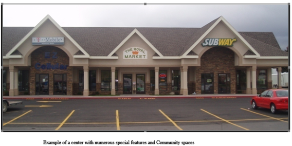
Entryway design elements and variations should give orientation and aesthetically pleasing character to the building.
- Each principal building on a site shall have clearly defined, highly visible customer entrances featuring no less than one (1) of the following:
- Canopies or porticos
- Overhangs
- Recesses/projections
- Architectural Arcades
- Raised corniced parapets over the door
- Peaked roof forms
- Arches
- Outdoor patios
- Display windows
- Architectural details such as tile work and moldings which are integrated into the building structure and design
- Integral planters or wing walls that incorporate landscaped areas and/or places for sitting
- Multiple Entrances. Large commercial buildings should feature multiple entrances. Multiple building entrances reduce walking distances from cars, facilitate pedestrian and bicycle access from public sidewalks, and provide convenience where certain entrances offer access to individual stores, or identified departments in a store.
- Additional Stores. Where additional stores will be located in the principal building, each store shall have at least one (1) exterior customer entrance, which shall conform to the above requirements. The number of entrances needed for a principal building shall be addressed at the preliminary development plan stage.
- Back and Sides. Any back or side of a building visible from a public or private right-of-way shall be built in accordance with subsection 6.00.030.
- Primary and Secondary Facing. Where a principal building directly faces more than two (2) abutting public or private rights-of-way, two (2) sides of the building shall feature a customer entrance including the side of the building facing the primary street, and another side of the building facing a secondary street.
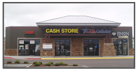
Exterior building materials and colors should be aesthetically pleasing and compatible with materials and colors used in adjoining neighborhoods.
- Colors
- Facade colors shall be low reflectance, subtle, neutral, or earth tone colors.
Repealed & Reenacted by Ord. 1115 Repealed Ord. 548, 642, 658, 915, 1021, 1027, 1095 and 1026; Development Code; Allowed smooth-faced concrete block, tilt-up concrete panels, prefabricated steel panels and vinyl siding form building sides that are not visual from the street or public parking. on 6/25/2014
Amended by Ord. 1251 on 2/17/2021
(See subsection 3.02.120.)
Loading areas and outdoor storage areas exert visual and noise impacts on surrounding neighborhoods.
- When visible from adjoining properties and/or public streets, these areas should be screened, recessed, or enclosed.
- Location.
- Areas for outdoor storage, truck parking, trash collection or compaction, loading, or other such uses shall not be visible from public or private rights-of-way.
- No areas for outdoor storage, trash collection or compaction, loading, or other such uses shall be located within twenty (20’) feet of any public thoroughfare or street, public sidewalk, or internal pedestrian way.
- Appropriate locations for loading and outdoor storage areas include areas between buildings, where more than one building is located on a site and such buildings are not more than forty (40’) feet apart, or on those sides of buildings that do not have customer entrances.
- Service Functions. Loading docks, truck parking, outdoor storage, utility meters, HVAC equipment, trash dumpsters, trash compaction, and other service functions shall be incorporated into the overall design of the building and the landscaping so that the visual and acoustic impacts of these functions are fully contained and out of view from adjacent properties and public streets, and no attention is attracted to the functions by the use of screening materials that are different from or inferior to the principal materials of the building and landscape.
- Non-enclosed areas for the storage and sale of seasonal inventory shall be permanently defined and screened with walls and/or fences.
- Materials, Colors, and Designs. Materials, colors, and designs of screening walls and/or fences shall conform to those used as predominant materials and colors of the building.
- Cover. If such areas are to be covered, then the covering shall conform to those used as predominant materials and colors on the buildings.
- Temporary sales/displays, such as Christmas trees, landscape materials, and fireworks, shall follow all outdoor requirements for all of the Commercial zones, as described in the Development Code.
- Location and time/duration of such sales/displays shall be reviewed and approved by the Zoning Administrator or appointed designee.
Pedestrian accessibility opens auto-oriented developments to the neighborhood, thereby reducing traffic impacts with the placement of public sidewalks and internal pedestrian circulation systems that can provide user-friendly pedestrian access as well as pedestrian safety, shelter, and convenience within the center grounds.
- Sidewalks. Sidewalks shall be at least five (5’) feet in width, (six (6’) feet in width where vehicle overhang will occur).
- Along Right-of-Way. Sidewalks shall be provided along all sides of the lot that abut a public or private right-of-way, excluding interstates.
- Along Building. Sidewalks shall be provided along the full length of the building along any facade featuring a customer entrance, and along any facade abutting public parking areas.
- From Facade. Sidewalks shall be located an average of six (6’) feet from the facade of the building to provide planting beds for foundation landscaping, except where features such as arcades or entryways are part of the facade.
- Doors. Entry/exit doors shall not be allowed to encroach upon the required sidewalk width when opened.
- The Planning and Zoning Commission may waive this requirement as part of a development agreement.
- Internal Pedestrian Walkways. Continuous internal pedestrian walkways, no less than five (5’) feet in width (six (6’) feet in width where vehicle overhang will occur), shall be provided from the public sidewalk or right-of-way to the principal customer entrance of all principal buildings on the site.
- Connections. At a minimum, walkways shall connect focal points of pedestrian activity such as, but not limited to, transit stops, street crossings, and building and store entry points.
- Landscape. Walkways shall feature adjoining landscaped areas that include trees, shrubs, benches, flower beds, ground covers, or other such materials for no less than fifty (50%) percent of their length.
- Materials. All internal pedestrian walkways shall be distinguished from driving surfaces through the use of durable, low maintenance surface materials such as pavers, bricks, or scored concrete to enhance pedestrian safety and comfort, as well as the attractiveness of the walkways.
- Signs. Signs shall be installed to designate pedestrian walkways.
Variations in roof lines should be used to add interest to and reduce the massive scale of large buildings. Roof features should complement the character of adjoining neighborhoods.
Facades should be articulated to reduce the massive scale and the uniform, impersonal appearances of large commercial buildings and provide visual interest that will be consistent with the community’s identity, character, and scale. Facades should encourage a more human scale that residents of Rexburg-Madison County will be able to identify with their community. The resulting scale will ensure a greater likelihood of reuse of structure by subsequent tenants.
- Wall Projections and Recesses. Developments with a facade over sixty (60’) feet in linear length that are visible from a city street, public way, or any facility or parking lot used by the general public shall incorporate wall projections or recesses a minimum of two (2’) feet in depth and a minimum of eight (8’) contiguous feet for each sixty (60’) feet of length and shall extend over twenty (20%) percent of the facade.
- Animating Features. Developments shall use animating features such as arcades, display windows, entry areas, or awnings on at least forty (40%) percent of the facade.
- Where there are additional, smaller separately-owned stores, with separate, exterior customer entrances located in the principal building or development side, the following standards apply:
- Street Level. The street level facade of such stores shall be transparent between the height of three (3’) feet and eight (8’) feet above the walkway grade for no less than forty (40%) percent of the horizontal length of the building facade of such additional stores.
- Windows. Windows and window displays should be used to contribute to the visual interest of exterior facades.
- Windows shall be recessed and should include visually prominent sills, shutters, or other such forms of framing.
Facades should be articulated to reduce the massive scale and the uniform, impersonal appearances of large commercial buildings and provide visual interest that will be consistent with the Community’s identity, character, and scale. Facades should encourage a more human scale that residents of Rexburg-Madison County will be able to identify with their Community. The resulting scale will ensure a greater likelihood of reuse of structure by subsequent tenants.
- Wall Projections or Recesses. Developments with façade over one-hundred (100’) feet in linear length shall incorporate wall projections or recesses a minimum of two (2’) feet depth and a minimum of twenty (20’) continuous feet within each one-hundred (100’) feet of facade length that is visible from a city street, public way, or any facility, or parking lot used by the general public and shall extend over twenty (20%) percent of the facade.
- Animating Features. Developments shall use animating features such as arcades, display windows, entry areas, or awnings along at least sixty (60%) of the facade.
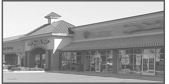
- Where principal buildings contain additional, smaller separately-owned stores, which occupy less than twenty-five thousand (25,000) square feet of gross floor area, with separate, exterior customer entrances, on a development site, the following regulations apply:
- Street Level. The street level facade of such stores shall be transparent between the height three (3’) feet and eight (8’) feet above the walkway grade for no less than sixty (60%) percent of the horizontal length of the building facade of such additional stores.
- Windows. Windows shall be recessed and should include visually prominent sills, shutters, or other such forms of framing.
Applications for large-scale, commercial structures or establishments shall include a reuse and maintenance plan that will afford maximum opportunity, consistent with the sound needs of the municipality as a whole, for the rehabilitation or redevelopment of the structure in the event of closure or relocation by the original occupant.
- Such plan will be approved if the Planning and Zoning Commission finds that all of the following items are adequate:
- Comprehensive Plan and Development Code Compliance. The plan conforms to the City's growth policy and the requirements of this title or parts thereof for the municipality as a whole.
- Sound Financial Program. A sound and adequate financial program exists for the financing of said redevelopment.
- Rehabilitation and Redevelopment. The plan affords maximum opportunity for rehabilitation or redevelopment of the structure by both private enterprise and the municipality.
- Normal Upkeep and Repairs. The reuse plan provides a maintenance plan for normal repairs and upkeep of property, including but not limited to building, parking lots and surfacing, landscaping, signage, and elimination of "ghost signage."
- Development Agreement. The City may enter into a development agreement with the owner of the real property and undertake activities, including the acquisition, removal, or demolition of structures, improvements, or personal property located on the real property, to prepare the property for redevelopment.
- A development agreement entered into in accordance with this section must contain provisions obligating the owner to redevelop the real property for the specified use consistent with the provisions of this title and offering recourse to the City if redevelopment is not completed as determined by the City.
- Uses Within Buildings. All uses established in a commercial zone shall be conducted entirely with in a fully-enclosed building except those uses deemed by the Planning and Zoning Commission to be customarily and appropriately conducted in the open. Such uses may include, but would not be limited to, service stations, ice skating, miniature golf, plant nurseries, etc.
- Trash Storage. (See subsection 3.02.120.)
- Materials and Location.
- Materials used for screening should be consistent with the predominant material found in the exterior construction of the building used by the business served.
- As a minimum, a vinyl fence will be allowed.
- Materials and Location.
6.01.020 Permitted Uses
6.01.030 Lot Area
6.01.040 Lot Width
6.01.050 Lot Frontage
6.01.060 Yard Requirements
6.01.070 Projections Into Yards
6.01.080 Building Height
6.01.090 Permissible Lot Coverage
6.01.120 Referenced Sections
All Zoning Standards apply. (See sections 3.1-3.7.)
All Commercial Zone Standards apply. (See section 6.0.)
Amended by Ord. 1188 Amended Ord. 1115; General Business District (GBD) and Community Business Center (CBC) will be Combined. on 7/18/2018
The Community Business Center Zone is established to provide an area in which a general shopping center facility can be established to satisfy the specialty shopping needs of a community or a group of neighborhoods. It is intended that the CBC zone will be characterized by specialty shops situated in an attractively designed shopping center complex surrounded by appropriate landscaping.
- Integrated Shopping Center. The CBC zone shall not be applied to an existing commercial development which has not been designed and constructed as an integrated community shopping center.
- Street Access. The CBC zone will be located adjacent to major thoroughfares or collector streets which will provide immediate access for automobile traffic without passing through residential areas.
Permitted Principal Uses. (See subsection 3.08.020)
Automobile Rental conditions: 1. Limited to passenger cars only. 2. Storage of vehicles on-site cannot exceed the parking allocated for the leasable floor space for the business. 3. No on-site servicing of the vehicle fleet including mechanical and wash facilities.
Permitted Accessory Uses. (See subsection 3.02.070.) Accessory uses and structures are permitted provided they are incidental to, and do not substantially alter the character of, the permitted principal use or structure.
Amended by Ord. 1263 on 1/5/2022
Amended by Ord. 1306 Full Ordinance Amends Conditional and Permitted Uses in All Zones on 12/20/2023
- The minimum area of any new subdivision in the CBC zone shall be five (5) acres; however, smaller lots or parcels may be created as part of an approved plat and recorded Record of Survey, as specified in City Code.
- Single ownership. Said land shall be in single ownership or single control for integrated development.
Each lot or parcel of land in the CBC zone shall have an average width of not less than five hundred (500’) feet; however, narrower lots or parcels may be created as part of an approved plat and recorded Record of Survey.
Each lot or parcel of land in the CBC zone shall abut on a public street for a minimum distance of five hundred (500’) feet, on a line parallel to the centerline of said street; however, lots or parcels with lesser frontage may be created as part of an approved and recorded Record of Survey.
- Primary Access. A portion of said frontage may be along the circumference of a cul-de-sac improved to City standards; however, the primary access for a community shopping center shall not be provided from a cul-de-sac street.
The following minimum yard requirements shall apply in the CBC zone:
- Front Yard. Each lot or parcel in the CBC zone shall have a front yard of no less than ten (10’) feet from the right-of-way.
- Said front yard shall not be used for vehicular parking and shall be appropriately landscaped.
- Exception: In areas developed prior to the establishment of this zone, the front yard may be equal to the average of existing front yards on all parcels of property along the block face in which a building or structure is to be located.
- Side Yard.
- Except as provided in the Rexburg Building Code, each lot or parcel of land in the CBC zone shall have a side yard of at least ten (10’) feet when located adjacent to a residential zone.
- Adjacent Commercial or Industrial. There shall be no requirement in those instances where the side property line abuts a commercial or industrial zone.
- Accessory Building on Side Property Line. (See subsection 3.02.060.)
- The accessory building shall provide facilities for the discharge of all roof drainage onto the lot or parcel on which it is erected.
- Rear Yard. No requirement unless adjacent to a residential zone or use, in which case, the rear yard setback shall match the setback requirement of the adjacent residential zone.
- Storage Units.
- Storage units are required to be built internally to a lot.
- Buffer.
- During the "Conditional Use Permit" proceedings, the applicant shall show how the storage units are being buffered from any street rights-of-way and neighboring properties. The most desirous buffering would be commercial buildings.
- Areas of landscaping greater in distance than the required yard setbacks should be included. These landscaped areas would need large nursery stock shrubs and trees to act as buffering.
- The landscaping and use of landscaping must be approved by the Planning and Zoning Commission.
(See subsections 3.02.090, 6.00.030.)
Exception: Permitted projections shall not project into required driveways; required driveways shall remain unobstructed from the ground up.
No lot or parcel of land in the CBC zone shall have a building or structure which exceeds a height of sixty-five (65') feet, measured at the top of building’s horizontal wall. (Chimneys, flagpoles, or similar structures not used for human occupancy and are excluded in determining height.)
- Building & Paving Coverage. In a CBC zone all buildings, structures, and non-permeable surfaces shall not cover an area of more than ninety (90%) percent of the lot or parcel of land upon which they are placed.
- Landscaping. A minimum of ten (10%) percent of the site shall be landscaped.
- Unpaved Areas. In addition to required landscaping, all unpaved areas shall be landscaped.
- Contiguous to Residential Zones. In a CBC zone in which a majority of the perimeter is contiguous to residential zones, all buildings, structures, and non-permeable surfaces shall not cover an area of more than seventy (70%) percent of the lot or parcel of land upon which they are placed.
- Landscaping. Landscaping shall be thirty (30%) percent of the lot.
- Remodeling in Existing CBC Zones. If the remodeling of a building in the CBC zone causes the exterior of the building to be enlarged, the landscaping requirements shall not fully apply where those requirements would conflict with parking requirements, be incompatible with the design of existing buildings or impair ingress or egress to existing buildings or parking areas.
- Prior Created Lots (See subsection 3.03.070.)
- Distance Between Buildings (See subsection 3.02.060.)
- Project Plan Approval (See subsection 3.02.120.)
- Highway 20 Corridor. (See subsection 3.02.090.G.)
- Signs. (See section 3.5.)
- Trash Storage. (See subsection 3.02.110.)
- Fences. (See subsection 3.02.100.)
- Commercial Design Standards (See section 6.0)
- Lighting (See section 3.6.)
- Transitional Development Standards. (See subsection 3.02.080.)
6.02.020 Permitted Uses
6.02.030 Single Ownership And Control
6.02.040 Lot Area
6.02.050 Lot Width
6.02.060 Lot Frontage
6.02.070 Yard Requirements
6.02.080 Projections Into Yards
6.02.090 Building Height
6.02.100 Permissible Lot Coverage
6.02.110 Parking, Loading And Access
6.02.120 Signs
6.02.130 Referenced Sections
All Zoning Standards apply. (See sections 3.1-3.7.)
All Commercial Zone Standards apply. (See section 6.0.)
Repealed & Reenacted by Ord. 1115 Repealed Ord. 548, 642, 658, 915, 1021, 1027, 1095 and 1026; Development Code; Allowed City Council to wave requirement of single ownership and control. on 6/25/2014
The RBC zone is established to provide a district in which the primary use of the land is for commercial and service uses to serve the needs of people living in an entire region and to serve as a place of employment in pleasant surroundings close to the center of the regional population it is intended to serve. It is intended that this zone shall be characterized by a variety of stores, shops, and service buildings grouped into an integrated development. Required yards and areas surrounding buildings shall be attractively landscaped and maintained in harmony with the characteristics of the surrounding residential areas.
The uses characteristic of this zone will be large chain department stores with satellite shops and facilities serving an extremely wide range of goods and services with an equally large selection of types and styles. The typical uses allowed in the zone will include virtually the whole range of retail and service establishments, which can be attractively accommodated within a unified shopping center complex.
- Integrated Regional Shopping Center. The RBC zone shall not be applied to an existing commercial area, which has not been designed and constructed as an integrated regional shopping center.
- Streets. The RBC zone should be located close to freeways and adjacent to major arterials to provide convenient access for major traffic volumes without hazard and without traversing through a residential area.
Permitted Principal Uses. (See subsection 3.08.020)
Permitted Accessory Uses. (See subsection 3.02.070.) Accessory uses and structures are permitted provided they are incidental to, and do not substantially alter the character of, the permitted principal use or structure.
Amended by Ord. 1263 on 1/5/2022
Amended by Ord. 1306 Full Ordinance Amends Conditional and Permitted Uses in All Zones on 12/20/2023
- Land within a given RBC zone shall be in single ownership or single control in order to provide for integrated development unless requested and approved by the Rexburg City Council.
- Single Ownership. The term, "single control", shall be construed to allow the recording of a Record of Survey.
- Consequence. Failure to maintain single ownership or single control may result in the initiation of action to return the property to the zone, or zones, existing prior to the establishment of the RBC zone.
- Record of Survey before Building Permits. The Record of Survey must be approved and recorded prior to the issuance of any building permits and must be in compliance with all applicable sections of the Rexburg City Code and other Building Codes adopted by the City of Rexburg.
The minimum area of any lot or parcel of land in the RBC zone shall be twenty (20) acres; however, smaller lots or parcels may be created as part of an approved and recorded Record of Survey, as specified in Rexburg City Code.
Each lot or parcel of land in the RBC zone shall have an average width of not less than seven hundred (700’) feet; however, narrower lots or parcels may be created as part of an approved and recorded Record of Survey, as specified in Rexburg City Code.
Each lot or parcel of land in the RBC zone shall abut on a public street for a minimum distance of five-hundred (500’) feet on a line parallel to the centerline of said street; however, lots or parcels with lesser frontage or no frontage on a public street may be created as part of an approved and recorded Record of Survey, which conforms to provisions specified in Rexburg City Code.
- Primary Access. A portion of the lot frontage may be along the circumference of a cul-de-sac improved to City standards; however, the primary access to a regional shopping center shall not be provided from a cul-de-sac street.
The following minimum yard requirements shall apply in the RBC zone:
- Front Yard. Each lot or parcel in the RBC zone shall have a front yard of not less than twenty (20’) feet from the right-of-way. Said front yard shall not be used for vehicular parking and shall be appropriately landscaped.
- Side Yard.
- Adjacent to Residential. Each lot or parcel of land in the RBC zone shall have a side yard of at least ten (10’) feet when located adjacent to a residential zone.
- Commercial or Industrial. There shall be no requirements in those instances where the side property line abuts a commercial or industrial zone.
- Accessory Building on Side Property Line. (See subsection 3.02.060.)
- Rear Yard.
- Adjacent to Residential. Each lot or parcel of land in the RBC zone shall have a rear yard of at least ten (10’) feet when located adjacent to a residential zone.
- Commercial or Industrial. There shall be no requirements in those instances where the rear property line abuts a commercial or industrial zone.
- Transitional Development Standards. (See subsection 3.02.080.)
Exception: Permitted projections shall not project into required driveways; required driveways shall remain unobstructed from the ground up.
No lot or parcel of land in the RBC zone shall have a building or structure which exceeds a seventy-five (75’) feet in height, measured at the top of building’s horizontal wall. (Chimneys, flagpoles, or similar structures not used for human occupancy are excluded in determining height.)
- In an RBC zone, all buildings and structures shall not cover an area of more than thirty (30%) percent of the lot or parcel of land upon which they are placed.
- Landscaping. A minimum of ten (10%) percent landscaping is required.
- Unpaved Areas. In addition, all unpaved areas shall be landscaped.
- Parking spaces and drive aisles, except ingress/egress points, shall not be provided within a required front yard adjacent to a public street without a minimum ten (10’).
- Loading Spaces. Loading spaces shall be provided unless applicant provides information to staff identifying acceptable alternate means.
- Change of Use. Loading spaces are also required when the use of a building changes unless applicant provides information to staff identifying acceptable alternate means.
- Signs. (See section 3.5 )
- Prior Created Lots (See subsection 3.03.070.)
- Distance Between Buildings (See subsection 3.02.060.)
- Project Plan Approval (See subsection 3.02.120.)
- Highway 20 Corridor. (See subsection 3.02.090.G.)
- Signs. (See section 3.5.)
- Trash Storage. (See subsection 3.02.110.)
- Fences. (See subsection 3.02.100.)
- Commercial Design Standards (See section 6.0)
- Lighting (See section 3.6.)
7.1 LIGHT INDUSTRIAL (LI)
7.2 HEAVY INDUSTRIAL (HI)
Recorded by Ord. 390 Section V Established an Industrial District on 3/16/1955
Adopted by Ord. 660 Pretreatment for Existing and New Sources of Pollution on 7/18/1984
Recorded by Ord. 907 Commercial Design Standards for Large Scale Commercial Developments located in the Highway Business District zone on 8/4/2004
7.00.020 Lot Frontage
7.00.040 Projections Into Yards
7.00.050 Building Height
7.00.060 Distance Between Buildings
7.00.070 Permissible Lot Coverage
7.00.080 Referenced Sections
All Zoning Standards apply. (See sections 3.1-3.7.)
Caretaker dwellings are allowed on a case by case basis as approved by the City of Rexburg Planning and Zoning Commission. Detailed plans are required.
Repealed & Reenacted by Ord. 1115 Repealed Ord. 548, 642, 658, 915, 1021, 1027, 1095 and 1026; Development Code; Allowed Caretaker dwellings to be allowed as per the P&Z Commission in Industrial zones on 6/25/2014
Each lot or parcel of land shall abut a public street for a minimum distance of thirty-five (35’) feet on a line parallel to the centerline of said street or along the circumference of a cul-de-sac improved to City standards.
Exception: Permitted projections shall not project into required driveways; required driveways shall remain unobstructed from the ground up.
- The height of every building or structure hereafter designed, erected, or structurally altered or enlarged, shall conform to the requirements of the Building Code as adopted by the City of Rexburg and shall not exceed fifty-five (55’) feet in maximum height.
- Additional height for a building or structure may be achieved through an approved Conditional Use Permit (CUP).
- Additional height for a building or structure may be achieved through an approved Conditional Use Permit (CUP).
No requirement except as may be dictated by the latest edition of the Rexburg Building Code as adopted by Rexburg City.
No requirement, except as may be dictated by off-street parking requirements, landscaping, and by the Planning and Zoning Commission to reduce the undesirable effects of a particular use upon adjacent properties.
- Prior Created Lots (See subsection 3.03.070.)
- Parking, Loading and Access (See section 3.4.)
- Highway 20 Corridor. (See subsection 3.02.090.G.)
- Project Plan Approval (See subsection 3.02.120.)
- Signs. (See section 3.5.)
- Trash Storage. (See subsection 3.02.110.)
- Fences. (See subsection 3.02.100.)
- Lighting (See section 3.6.)
7.01.020 Permitted Uses
7.01.030 Lot Area
7.01.040 Lot Width
7.01.050 Yard Requirements
7.01.060 Planning And Building
7.01.070 Referenced Sections
All Zoning Standards apply. (See 3.01-3.06)
All Standards for Industrial Zones apply. (See 7.0)
The LI District is established to provide areas in the City where Light Industrial firms can engage in processing, assembling, manufacturing, warehousing, storage and wholesale distribution; and for incidental service facilities and public facilities to serve the manufacturing area. Areas in this zone require large level sites with open storage and service areas which utilize regional transportation such as railways and state highways and the available utilities necessary for successful manufacturing or processes The zone is intended to encourage sound development by providing and protecting an environment for such development, subject to regulations necessary to assure the orderly growth of the City of Rexburg, and the protection of residential and commercial land uses from noise and other disturbances.
- Land Reserves. The areas in which this zone will be applied may provide for land reserves for industrial and manufacturing use. Some land may therefore be placed in agricultural and other open land uses until its industrial and manufacturing potential is realized.
- Objectives. The basic objectives of the LI zone are:
- To provide space for Light Industrial and processing uses within the City in appropriate locations
- To broaden the tax base and improve the economic base of the community
- To promote new industry to the end that the economic and social well-being of the City and its inhabitants shall be enhanced
- To discourage the undesirable mixture of incompatible commercial, industrial, and residential uses
Permitted Principal Uses. (See subsection 3.08.020)
Permitted Accessory Uses. (See subsections 3.02.070., 7.00.010.) Accessory uses and structures are permitted provided they are incidental to, and do not substantially alter the character of, the permitted principal use or structure.
Amended by Ord. 1263 on 1/5/2022
Amended by Ord. 1306 Full Ordinance Amends Conditional and Permitted Uses in All Zones on 12/20/2023
The minimum area of any lot or parcel of land in the LI zone shall be 1/2 acre.
Each lot or parcel of land in the LI zone shall have an average width of not less than fifty (50’) feet.
The following minimum yard requirements shall apply in the LI zone:
- Front Yard. Each lot or parcel in the LI zone shall have a landscaped front yard of not less than ten (10’) feet from the right-of-way.
- Side and Rear Yard. No side and/or rear yard required unless adjacent to Residential or Commercial Zones.
- Adjacent to Residential. Buildings adjacent to residential shall have a minimum setback of twenty (20') feet or a setback of six (6") inches for every one (1') foot of building height, whichever is greater.
- Accessory Building. (See subsection 7.00.030.)
- An orderly development pattern following good planning principles shall be used.
- Uses Within Buildings. All uses established in the LI zone shall be conducted entirely within fully-enclosed buildings, except those uses deemed by the Planning and Zoning Commission to be customarily and appropriately allowed in the zone by a conditional use permit with appropriate screening.
- Lot Frontage (See subsection 7.00.020.)
- Building Height (See subsection 7.00.050.)
- Distance Between Buildings (See subsection 7.00.060.)
- Permissible Lot Coverage (See subsection 7.00.070.)
- Prior Created Lots (See subsection 3.03.070.)
- Projections Into Yards (See subsections 7.00.040., 3.02.080.)
- Parking, Loading and Access (See section 3.4.)
- Project Plan Approval (See subsection 3.02.120.)
- Highway 20 Corridor. (See subsection 3.02.090.G.)
- Trash Storage. (See subsection 3.02.110.)
- Walls and Fences. (See subsection 3.02.110.)
- Signs. (See section 3.5.)
- Lighting Standards (See section 3.6.)
7.02.020 Permitted Uses
7.02.030 Lot Area
7.02.040 Lot Width
7.02.050 Yard Requirements
7.02.060 Planning And Uses In Buildings
7.02.070 Referenced Sections
All Zoning Standards apply. (See sections 3.1-3.7.)
All Standards for Industrial Zones apply. (See section 7.0.)
The HI Zone is established to provide areas in the community where heavy industrial, manufacturing, and extractive uses may be located in an environment which protects them from the encroachment of commercial and residential uses, and which reduces the effect of undesirable characteristics such as odor, dust, and noise upon surrounding residential or commercial areas. The HI zone is established to recognize the need for industrial sites, which are generally major and extensive operations, require large level sites, and would normally have open storage and service areas. The zone is also intended to provide for the development of incidental service facilities such as restaurants, service stations, and public facilities intended primarily to serve the industrial area.
- Location. The HI (Heavy Industrial) zone should be located in areas which are readily accessible to railroads and major highway routes.
- Truck traffic generated by the HI zone shall not be required to ingress and egress from industrial areas through a residential area or commercial district.
- Said zone shall also be located in areas which will insure the purity of air and waters within Rexburg City and will not create hazards to nearby residential, commercial, or Light Industrial areas as the result of noise, dust, fumes, or other disturbances.
- These uses will be located in areas which will reduce the effects of these characteristics upon other areas of the community, and in an environment which is attractive but which recognizes the characteristics of the permitted uses.
- Uses. The HI zone accommodates heavy industrial uses such as, open and enclosed manufacturing, processing, and assembly, which may potentially create hazards, nuisances, or disturbances. This zone accommodates these heavy industrial uses with a conditional use permit (CUP) to assure that land use conflicts are minimized.
- Peripheral Landscaping. Some peripheral landscaping will be provided, where appropriate, to reduce the effects of the detrimental characteristics of permitted uses, and to enhance the appearance of the entire HI zone.
Permitted Principal Uses. (See subsection 3.08.020)
Permitted Accessory Uses. (See subsections 3.02.070., 7.00.030.) Accessory uses and structures are permitted provided they are incidental to, and do not substantially alter the character of, the permitted principal use or structure.
Amended by Ord. 1306 Full Ordinance Amends Conditional and Permitted Uses in All Zones on 12/20/2023
There is no minimum area for any lot or parcel of land in the HI zone.
Each lot or parcel of land in the HI zone shall have an average width of not less than one hundred fifty (150’) feet.
(See subsection 3.02.070.)
The following minimum yard requirements shall apply in the HI zone:
- Front Yard. Each lot or parcel of land in the HI zone shall have a landscaped front yard of at least ten (10’) feet from the right-of-way.
- Side Yard. No side yard requirement unless imposed by the Zoning Administrator to protect adjacent properties against the undesirable characteristics of a particular use; or as required by the Building Code adopted by the City of Rexburg.
- Side & Rear Yard Accessory Building. (See subsection 7.00.030.)
- Rear Yard. Where the rear property line abuts on a residential or commercial zone, the rear yard shall be the same as that required by the adjacent zone, or as determined by the Zoning Administrator to mitigate potential nuisances. Otherwise, no setback required.
- Adjacent to Residential. Buildings adjacent to residential shall have a minimum setback of twenty (20') feet or a setback of six (6") inches for every one (1') foot of building height, whichever is greater.
- An orderly development pattern following good planning principles shall be used.
- Uses Within Buildings. No requirement, except as may be imposed by the Planning and Zoning Commission in conjunction with the issuance of a conditional use permit.
- Lot Frontage (See subsection 7.00.020.)
- Building Height (See subsection 7.00.050.)
- Distance Between Buildings (See subsection 7.00.060.)
- Permissible Lot Coverage (See subsection 7.00.070.)
- Prior Created Lots (See subsection 3.03.070.)
- Projections Into Yards (See subsections 7.00.040., 3.02.090.)
- Parking, Loading and Access (See section 3.4.)
- Project Plan Approval (See subsection 3.02.120.)
- Highway 20 Corridor. (See subsection 3.02.090.G.)
- Trash Storage. (See subsection 3.02.110.)
- Walls and Fences. (See subsection 3.02.100.)
- Signs. (See section 3.5.)
- Lighting Standards (See section 3.6.)
8.2 PUBLIC FACILITIES (PF)
8.3 UNIVERSITY DISTRICT (UD)
8.4 RESIDENTIAL BUSINESS DISTRICT (RBD)
8.5 PROJECT REDEVELOPMENT OPTION (PRO)
All Zoning Standards apply. (See 3.01-3.06)
Amended by Ord. 1159 Amended Ord. 1115; Removed Neighborhood Business District and Rezoned to Community Business Center or Central Business District on 5/3/2017
8.01.020 Permitted Uses
8.01.030 Project Requirements
8.01.040 Lighting Standards
All Zoning Standards apply. (See sections 3.1-3.7.)
The OS Zone is established to recognize areas of recreational and public uses and to protect floodplains, slopes, and natural drainage ways from development that may cause or contribute to flooding, slope failures, excessive soil erosion, and sediment and water pollution of the Teton River. The floodplain is defined by the FIRM for Rexburg.
Permitted Principal Uses. (See subsection 3.08.030)
Amended by Ord. 1306 Full Ordinance Amends Conditional and Permitted Uses in All Zones on 12/20/2023
- Any construction projects taking place in this zone that are not listed as “Permitted Uses” shall obtain a conditional use permit.
- Details shall be presented to the Planning and Zoning Commission and Zoning Commission for approval.
8.02.020 Permitted Uses
8.02.030 Lot Area
8.02.040 Lot Width
8.02.050 Lot Frontage
8.02.060 Yard Requirements
8.02.070 Building Height
8.02.080 Distance Between Buildings
8.02.090 Permissible Lot Coverage
8.02.100 Landscaping And Land Use Impacts
8.02.110 Referenced Sections
All Zoning Standards apply. (See 3.01-3.06)
Amended by Ord. 897 Amended Ord. 894 Sect.3.6,3.7,3.8 and 3.6.1; Addition of Design Standards for Multi-Family Housing, Public and Institutional buildings, Neighborhood Commercial and Mixed-use buildings on 7/2/2003
Amended by Ord. 1210 Rezoned Various Government-Owned properties to Public Facilities on 5/15/2019
This zone is intended to reduce the affect which the location of these facilities may have upon zoning statistics in residential, commercial, or industrial areas. Typical uses will be allowed in other zones to initially accommodate public facilities in appropriate areas without undue difficulty, however, it is intended that the PF zone would then be applied to all such facilities for ease of recognition and accurate statistical indexing.
Permitted Principal Uses. (See subsection 3.08.030)
Permitted Accessory Uses. (See subsection 3.02.070.) Accessory uses and structures are permitted provided they are incidental to, and do not substantially alter the character of, the permitted principal use or structure.
- Swimming pools and incidental bath houses subject to the standards of Rexburg City Code;
- A detached single-family residence used only for the use of a caretaker, watchman, or similar employee of a permitted use, when located upon the same site as said permitted use;
- Nothing herein shall be construed to permit the open storage of materials or equipment used in conjunction with permitted uses, or shall be concealed from view from public or private streets.
Public facilities, public schools and parks which are currently in existence by legal process, may modify for continued use, provided any changes are submitted to the City for administrative review and approval.
Amended by Ord. 1212 Amended Ord. 1200; Added Fairgrounds, Golf Course, Sports Fields and Swimming Pools to Outdoor Recreation; Added Theatres to Indoor Recreation as Permitted Uses; Added Public facilities, public schools and parks which are currently in existence by legal process, may modify for continued use, provided any changes are submitted to the City for administrative review and approval. on 6/5/2019
Amended by Ord. 1263 on 1/5/2022
Amended by Ord. 1306 Full Ordinance Amends Conditional and Permitted Uses in All Zones on 12/20/2023
No minimum lot size.
No minimum lot width.
No minimum lot frontage.
The following minimum yard requirements shall apply to the PF zone:
- Front Yard. Each lot or parcel of land in the PF zone shall have a front yard of not less than ten (10’) feet from the right-of-way.
- Adjacent to Residential. Lots or parcels lying adjacent to a residential zone along the same street frontage shall have a front yard equal to that required by the provisions of the most restrictive residential zone which it abuts along said street frontage.
- Side & Rear Yard.
- Adjacent to Residential. When the parcel of property in the PF zone abuts the side or rear yard of a lot or parcel lying within a residential zone, the yard width shall be equal to that required by the provisions of the residential zone established on the abutting property.
- Otherwise, no setback requirement.
- Permitted Building Height with Conditions. No lot or parcel of land in the PF Zone shall have a building or structure which exceeds a height of fifty-five (55’) feet, measured at the top of building’s horizontal wall, unless one of the following conditions exists:
- The horizontal setback of the building from the nearest residential zone boundary is equal to or exceeds twice the building's height; or
- A Conditional Use Permit has been granted by the Planning and Zoning Commission in accordance with the provisions of Rexburg City Code. Unique characteristics of a particular building site (such as significant topographic differences between the building site and adjoining residential properties) may justify the City's Zoning Administrator requiring the project to undergo Conditional Use Review, even though the condition outlined in (1) above is satisfied. A Conditional Use Permit may allow heights greater than fifty-five (55’) feet.
- Height restrictions within this district are determined by the Federal Aviation Administration regulating the approach zone of the airport under FAR part 77, Airspace .
Amended by Ord. 1212 Amended Ord. 1200; The horizontal setback of the building from the nearest residential zone boundary is equal to or exceeds twice the building' height. on 6/5/2019
Accessory Building. (See subsection 3.02.060.) The accessory building shall be under ten (10’) feet in height and less than two hundred (200) square feet in area.
In a PF Zone, all buildings and structures shall not cover more than sixty (60%) percent of the lot or parcel of land upon which they are placed.
- Landscaping. A minimum of ten (10%) percent of the site shall be landscaped.
- Mitigating Land Use Impacts. (See subsection 1.03.020.C.) Any change of use that creates more intense impacts may be denied if the Planning and Zoning Commission finds that such impacts cannot be mitigated by the imposition of conditions.
- Prior Created Lots (See subsection 3.03.070.)
- Projections Into Yards (See subsection 3.02.080.)
- Transitional Development Standard (See subsection 3.02.080.)
- Parking, Loading and Access (See section 3.4.)
- Project Plan Approval (See subsection 3.02.120.)
- Highway 20 Corridor. (See subsection 3.02.090.G.)
- Trash Storage. (See subsection 3.02.110.)
- Signs (See section 3.5.)
- Lighting (See section 3.6.)
8.03.020 Permitted Uses
8.03.030 Lot Area
8.03.040 Lot Width
8.03.050 Lot Frontage
8.03.060 Density
8.03.070 Yard Requirements
8.03.080 Building Height
8.03.090 Distance Between Buildings
8.03.100 Permissible Lot Coverage
8.03.110 Parking, Loading, And Access
8.03.120 Landscaping
8.03.130 Change In Use Of University Facilities
8.03.140 Referenced Sections
All Zoning Standards apply. (See sections 3.1-3.7.)
Amended by Ord. 866 Amended Ord. 725 Amended University District Definition; Amended the Land Use Schedule on 4/3/2002
The University District is established to provide areas for the location and establishment of educational facilities which operate as institutions of higher learning and which utilize relatively large areas of land, while protecting adjacent land uses from nuisance and otherwise incompatible land use. The University campus is unique in its nature as to those who visit, work, and attend the University. The UD zone is intended for only land that is owned by Brigham Young University- Idaho.
- Change of owner. If any land is sold, gifted, or transferred to another financially unrelated party,
- Rezone. A new zoning category must immediately be sought.
- Moratorium. Immediately, there will be a moratorium based on approval of new land uses and building permits on the property until a new zoning district can be established.
- Streets. The campus as a whole is served by all public streets adjacent to and running through the campus as well as private roads and streets owned and maintained by the University.
- Parking. Parking on the campus should be located in a manner which will serve the needs of invitees to the campus. All buildings, playing fields and other structures on the Campus should be deemed served by all parking lots on campus, wherever situated.
Permitted Principal Uses. (See subsection 3.08.030)
Permitted Accessory Uses. (See subsection 3.02.070.) Accessory uses and structures are permitted in the UD zone provided they are incidental to, and do not substantially alter the character of the permitted use or structure, and are located on the same or an adjacent lot as the permitted use. Such permitted accessory uses and structures include, but are not limited to the following:
- A public dance held in conjunction with an existing permitted use.
- Swimming pools and incidental bath houses subject to the standards of Rexburg City Code.
- A detached single-family residence used only for the use of a caretaker, watchman, or similar employee of a permitted use, when located upon the same site as said permitted use.
- Dormitories, fraternity and sorority buildings, other college housing owned by the college or university recreational and service facilities, and office buildings customarily associated with an educational facility or other institutional use, when said facilities are accessory and incidental to the primary use of the land.
- Nothing herein shall be construed to permit the open storage of materials or equipment used in conjunction with permitted uses, or shall be concealed from view from public or private streets.
Amended by Ord. 1075 Amended Ord. 1026; University District Conditional Uses to include Veterinary Services for Livestock (Totally Enclosed) and Livestock Services, and Livestock Services, Except Veterinary (Totally Enclosed) on 10/19/2011
Amended by Ord. 1263 on 1/5/2022
Amended by Ord. 1306 Full Ordinance Amends Conditional and Permitted Uses in All Zones on 12/20/2023
The University campus should be considered as one parcel.
- There is no minimum lot area in the University Zone.
- Parcels sold or otherwise vacated by the University must meet the minimum lot requirements of the intended zone.
- Caretaker Dwelling. Any caretaker dwelling established in conjunction with a permitted use in the UD zone shall have a land area of at least five thousand (5,000) square feet devoted exclusively to the use of the inhabitants of said residential unit.
There is no minimum lot width in the University Zone.
For the purposes of this ordinance, the university zone shall be considered one contiguous parcel. There is no minimum lot frontage requirement on this large parcel.
- Up to forty-eight (48) dwelling units per building or development
- Greater than forty-eight (48) dwelling units per building or development may be allowed with a Conditional Use Permit.
The following minimum yard requirements shall apply to the UD zone:
- Front Yard. Front yard setback requirements where the University Zone abuts a residential zone or non-University owned parcel shall be at a 1:1 ratio, or 1 (1’) foot for every (1’) foot of building height from the right of way.
- Side Yard. Side yard setback requirements where the University Zone abuts a residential zone or non-University owned parcel shall be at a 1:1 ratio, or 1 (1’) foot for every (1’) foot of building height. (This requirement is twice that of a typical residential side yard.)
- Rear Yard. Minimum of twenty (20’) feet.
Building height is unrestricted in the University Zone as long as the 1:1 setback ratio is met on buildings constructed adjacent to non-university owned parcels.
Side Yard Accessory Building. Accessory building on a side property line. (See subsection 3.02.060.)
In a UD zone, all buildings and structures, inclusive of parking lots, shall not cover more than sixty (60%) percent of the lot or parcel of land upon which they are placed.
- Off-street parking shall not be required to be located within two hundred (200') feet of the primary entrance of the building.
- The Planning and Zoning Commission can approve parking to be farther than two hundred (200') feet of the primary entrance of the building with a Conditional Use Permit.
- The Planning and Zoning Commission can approve parking to be farther than two hundred (200') feet of the primary entrance of the building with a Conditional Use Permit.
- In the University District, the subsection 3.04.090 shall not apply, however, the University shall provide information which demonstrates that the parking facility proposed to be considered for joint use, will lessen the demand for other parking facilities located in the University District.
- Regulations for University District. The University shall not be required to provide the minimum parking spaces required in section 3.4, but shall be regulated in accordance with the University Parking Ratios as set forth below. In determining the ratio for this subsection, all parking spaces located upon the University Campus together with all on-street parking where the University Campus occupies both sides of the street shall be included. The term Full Time Equivalent shall be consistent with the definition established in the BYU-Idaho Parking Study published in 2002.
- University Student Ratio: 0.200 spaces per Student Equivalent.
- University Faculty Ratio: 0.585 spaces per Faculty Equivalent.
- University Staff Ratio: 0.585 spaces per Staff Equivalent.
- Paving. All parking spaces shall be paved with asphaltic cement or concrete, and shall be provided with paved access from the public street.
- Curbing. Landscaped front yards and other required buffer yards shall be delineated from parking areas by high-back curbing that will further discourage parking in the front yard.
- Reduced front yard setback CUP. If the building location is approved by a Conditional Use Permit with a reduction in the front yard setback up to fifteen (15’) feet; then the twenty (20%) percent landscaping requirement may be reduced down to as little as ten (10%) percent upon approval of the Zoning Administrator.
- Location of Parking Spaces. Parking spaces shall not be provided within a required front yard or a side yard adjacent to a public street.
Repealed & Reenacted by Ord. 1115 Repealed Ord. 548, 642, 658, 915, 1021, 1027, 1095 and 1026; Development Code; Allowed parking to be farther than 200' with a CUP. on 6/25/2014
Amended by Ord. 1159 Amended Ord. 1115; Building Location approved by a CUP with a Reduction in the Front Yard Setback Landscaping Percentages on 5/3/2017
- A minimum of twenty (20%) percent of the site shall be landscaped.
- All residential development shall provide a minimum of ten (10%) percent landscaping.
- Conditional Use Permit.
- Change of Use. Before any existing University facility use may be changed to another use, but under the same ownership, a Building Permit must be taken out with the City of Rexburg.
- The use must be compatible with the City of Rexburg Development Code and the current Rexburg Building Codes.
- Mitigating Land Use Impacts. (See subsection 1.03.020.C.) Any change of use that creates more intense impacts may be denied if the Planning and Zoning Commission finds that such impacts cannot be mitigated by the imposition of conditions.
- Prior Created Lots (See subsection 3.03.070.)
- Projections Into Yards (See subsection 3.02.080.)
- Project Plan Approval (See subsection 3.02.120.)
- Trash Storage. (See subsection 3.02.110.)
- Signs. (See section 3.5.)
- Lighting Standards (See section 3.6.)
8.04.020 Permitted Uses
8.04.030 Single Ownership And Control
8.04.040 Lot Area
8.04.050 Lot Width
8.04.060 Lot Depth
8.04.070 Lot Frontage
8.04.080 Yard Requirement
8.04.090 Building Height
8.04.100 Permissible Lot Coverage
8.04.110 Permissible Building Footprint
8.04.120 Parking, Loading And Access
8.04.130 Project Plan Approval
8.04.140 Reversion Of Zoning
8.04.150 Other Requirements
8.04.160 Lighting Standards
8.04.170 Referenced Sections
All Zoning Standards apply. (See sections 3.1-3.7.)
The RBD zone is established to provide for the use of single family residential homes for commercial and service uses. The zone is intended to protect the residential nature of the streetscape and provide strict regulation of types and hours of conduct of commercial uses. It is intended that the RBD zone shall be characterized by a single structure that will function as a part of the greater neighborhood. Commercial uses are limited to non-intrusive, low-demand business that can peacefully co-exist with a surrounding neighborhood.
- Objectives.
- A single structure that will function as a part of a greater neighborhood.
- The architectural design and character will be compatible with that of the surrounding residential environment.
- Attractive and well-maintained landscaping will also be characteristic of this zone.
- Location. The RBD zones shall only be allowed if the area requested for designation as such is contiguous to either a commercial zone other than RBD, industrial zone, or a medium or high density residential zone.
Permitted Principal Uses. (See subsection 3.08.020)
Permitted Accessory Uses. (See subsection 3.02.070.) Accessory uses and structures may be permitted provided they are incidental to, and do not substantially alter the character of, the permitted principal use or structure.
Amended by Ord. 1306 Full Ordinance Amends Conditional and Permitted Uses in All Zones on 12/20/2023
- Land within a given RBD zone shall be in single ownership or single control in order to provide control over development.
- Consequence. Failure to maintain single ownership or single control may result in the initiation of action to return the property to the zone, or zones, existing prior to the establishment of the RBD zone.
The minimum area of any lot or parcel of land in the RBD zone is eight thousand (8,000) sq. ft.
The minimum lot width in the RBD zone is sixty (60’) feet.
The minimum lot depth in the RBD zone is sixty (60’) feet.
Each lot or parcel of land in the RBD zone shall abut a public street for a minimum distance of twenty (20’) feet, on a line parallel to the center line of the street or along the circumference of a cul-de-sac improved to City standards. Frontage on a street end which does not have a cul-de-sac improved to City standards shall not be counted in meeting this requirement.
The following minimum yard requirements shall apply in the RBD Zone:
- Front Yard.
- Each lot or parcel in the RBD zone shall have a minimum front yard of at least twenty-five (25’) feet from the right-of-way.
- Exception: When the street upon which the parcel fronts has a boulevard strip of at least seven (7’) feet, the front yard setback may be reduced to twenty (20’) feet from right-of-way.
- Rear Yard.
- The minimum depth of a rear yard shall be twenty (20’) feet.
- Accessory building.
- An accessory building or group of accessory buildings in any residential zone shall not cover more than thirty (30%) percent of the rear yard.
- Accessory buildings in the rear yard with a garage and doors opening into the alley shall be located at least fifteen (15’) feet from the alley.
- Side Yard. Each lot or parcel of land in the RBD zone shall have a side yard of at least six (6’) feet or six (6”) inches of setback for every (1) foot of building height, whichever is greater.
- Accessory Building Setbacks. (See subsection 3.02.070.)
Permitted Heights. No lot or parcel of land in the RBD zone shall have a building or structure which exceeds a height of three (3) stories with a maximum of thirty-five (35’) feet, measured at the top of building’s horizontal wall. (Chimneys, flagpoles, or similar structures not used for human occupancy are excluded in determining height.)
- In an RBD zone, all buildings and structures shall not cover an area greater than seventy (70%) percent of the area of the lot or parcel of land.
- No more than forty (40%) percent of the rear yard (unless a greater percentage is approved by the Rexburg Planning and Zoning Commission) shall be put into hard surface in order to maintain a residential character to the property.
In an RBD zone, all buildings and structures shall have a footprint of no more than two-thousand, five hundred (2,500) square feet.
Each lot or parcel in the RBD zone shall have, on the same lot or parcel, automobile parking sufficient to meet the requirements as set forth in section 3.4.
- Location. Parking spaces shall not be provided within a required front yard or side yard adjacent to a public street, except where an existing conforming driveway access has been provided.
- Corner Lots. Corner lots shall be allowed to petition for parking in side yards, provided any such parking shall be buffered visually and for sound from public rights of way and adjoining residential properties.
- Parkers. Parking areas within the RBD zone are to be used by occupants of the property and customers of the property, and are not to be used by employees or customers of businesses that may be located in nearby business or commercial areas.
Infrastructure Plan Approval. Infrastructure plan approval at the Planning and Zoning Commission level is mandatory before consideration of a RBD Zone change request may be initiated.
If violations of the approval conditions for a rezone to the RBD Zone are documented and not corrected in a timely manner by property owner, property zoning will revert to the zone existing before application for the RBD zone.
- Uses within Buildings. All uses established in the RBD zone shall be conducted entirely within a fully-enclosed building.
- Landscaping. At least thirty (30%) percent of the area of any lot shall be maintained in landscaping unless specific permission has been obtained from the Planning & Zoning Commission.
- Hours of Operation. In the RBD zone, no permitted or conditionally permitted use shall be open for business on any Sunday, or after 9:00 P.M. or before 7:00 A.M. on any other day, nor shall any permitted or conditionally permitted use accept deliveries other than between the hours of 9:00 a.m. and 3:00 p.m., with no deliveries allowed at all on Sundays.
- Signs. (See section 3.5.)
- Lighting will be of a relatively low intensity and low profile with adequate shielding to protect the surrounding residential areas.
- Lighting Standards are applicable as described in section 3.6.
- Prior Created Lots (See subsection 3.03.070.)
- Projections Into Yards (See subsection 3.02.090.)
- Highway 20 Corridor. (See subsection 3.02.100.F.)
- Trash Storage. (See subsection 3.02.120.)
- Walls and Fences. (See subsection 3.02.110.)
8.05.020 Neighborhood Meeting
8.05.030 Preliminary Schematic Development Plan
8.05.040 Review Of Preliminary Schematic Development Plan
8.05.050 PRO Zone Application Requirements
8.05.060 PRO Zone Application Approval
8.05.070 Zone Designation
8.05.080 Final Project Plan
8.05.090 Additional Applications
8.05.100 Project Plan Variations And Amendments
8.05.110 Reversion Of Zoning
8.05.120 PRO Zones Adopted
8.05.130 Uses Must Be In Conformity
8.05.140 Building In Conformity
8.05.150 Referenced Sections
All Zoning Standards apply. (See 3.01-3.06)
This chapter creates a regulatory framework to govern the enactment of regulations to further the intent of the Vision 2020 Comprehensive Plan, particularly, but not exclusively, in older, densely developed areas of the City. The purpose of the Project Redevelopment Option (“PRO”) zone is to create a regulatory tool that permits initiative and flexibility in creating well-planned, architecturally-designed development that meets the needs of the community. The provisions of this chapter shall apply to every PRO zone created under the authority of this chapter.
- Objectives.
- Encourage creative and efficient utilization of land.
- Encourage assemblage of property to create harmonious and efficient development patterns and projects.
- Provide land use and design standards tailored to specific geographic areas so that new development outcomes are more predictable and compatible with surrounding land uses.
- Coordinate property development and design, including large-scale facilities, with development, both existing and as envisioned by the City of Rexburg Comprehensive Plan, on adjoining and nearby property.
- Minimize the effect of additional traffic.
- Improve parking and air quality.
- Encourage new development that fosters a sense of community.
- Better manage the location, timing, and sequencing of new development.
- Provide an opportunity to involve the public.
A neighborhood meeting shall be held at least two (2) weeks prior to presenting a schematic development plan at a meeting of the Planning and Zoning Commission.
- Schematic Plan Submittal. Prior to submitting a PRO application, an applicant may submit a proposed schematic development plan for the subject property.
- A schematic development plan shall be considered by the Planning and Zoning Commission and City Council as provided in this section.
- What to Include in a Schematic Development Plan: A schematic development plan application shall include the following:
- Fee. A review fee of five hundred ($500) dollars.
- Fifty percent (50%) of the schematic development plan application fee may be applied to the application fee for a PRO zone if the City Council recommends that an applicant submit the application.
- A statement detailing efforts by the applicant to assemble property to achieve logical boundaries for the proposed development.
- A schematic development plan which shows how a property could be developed under proposed PRO zone regulations.
- Scale. A schematic development plan shall be drawn to scale.
- Example of Applying Standards. The plan must show a realistic layout reflecting how the property reasonably could be developed considering the development standards of a proposed PRO zone.
- Present and Future Conditions. The plan should show existing and envisioned conditions on the subject property and adjoining property.
- A schematic development plan should show at least the following; whatever is shown shall be construed as the intent of the plan:
- Location of proposed uses, including dwelling unit density and occupancy.
- Height, location, bulk and preliminary elevations of buildings.
- Location, arrangement, and configuration of open space, landscaping, and building setbacks.
- Location, access points, and design of off-street parking areas.
- Number, size, and location of signs.
- Street layout, and traffic and pedestrian circulation patterns, including proposed access to the property.
- Relationship of the property to adjoining and nearby properties and uses.
- Not a Permit. A schematic development plan is not intended to permit actual development of property pursuant to such a plan but shall be prepared merely to represent how the property could be developed.
- No Vested Development Rights. Submittal and review of an application for a schematic development plan shall not create any vested rights to development.
- Fee. A review fee of five hundred ($500) dollars.
- Process Leading to the Public Hearing. Pursuant to the notice and hearing requirements of the State and Rexburg City Code, the schematic development plan shall be first submitted to the Planning and Zoning Commission for a recommendation and thereafter to the City Council for consideration. After a public hearing, the Council may vote to recommend that an applicant:
- Submit an application for a PRO zone that would allow development:
- As shown on the schematic development plan; or
- As amended to address issues identified by the City Council to accomplish the goals and objectives of the Vision 2020 Comprehensive Plan; or
- Not submit a PRO zone application.
- Submit an application for a PRO zone that would allow development:
- Requirements. The following materials shall be included with every application for establishment of a PRO zone:
- Proposed zone name and location.
- A statement showing how the proposed PRO zone relates to the Comprehensive Plan and furthers the intent of the Plan.
- A statement detailing efforts by the applicant to assemble property to achieve logical boundaries for the proposed development.
- Proposed zone text, including:
- Permitted, conditional, and accessory uses (specifically listed and defined).
- Proposed development standards, including:
- Land use standards establishing land use types, occupancy, location, density, buffering and any other element envisioned by applicable sections of the General Plan.
- Lot standards establishing requirements for minimum lot area, depth, coverage, and dimensions.
- Building setback standards for front, side, and rear yards.
- Design standards addressing building height, building orientation, common and private open space, natural resource protection, architectural design, and any other provisions proposed to be included in the PRO zone.
- Landscaping and buffering standards.
- Parking.
- A statement that the PRO zone will conform to all applicable chapters of Rexburg City Code, except as may be specifically amended by the adopted PRO zone text.
- Evidence of justification for requested changes to such standards. Deviations from parking and street standards set forth in Rexburg City Code are intended to be rare and shall be approved by five (5) members of the City Council.
- A preliminary project plan as provided in this Title and including the following additional information:
- Relationship of the property to surrounding properties and uses.
- Number, size, and location of all proposed signs.
- A review fee of one thousand ($1,000) dollars plus a fee of:
- Thirty ($30) dollars for each dwelling unit proposed in a residential project; or
- Ten ($10) dollars for each one hundred (100) square feet of gross floor area in a non-residential project.
- A public hearing notice fee as required.
When considering an application for a proposed PRO zone, the Planning and Zoning Commission may recommend, and the City Council may adopt, modifications to PRO regulations and standards proposed by an applicant who, in the opinion of the approving authority, is needed to meet the intent and requirements of this chapter.
- Approval. A proposed PRO zone application and associated preliminary project plan shall be approved only if, in the opinion of the approving authority, development proposed on the property will:
- Further applicable provisions of the Vision 2020 Comprehensive Plan and any applicable master plan, particularly provisions which establish density limitations.
- Conform to applicable chapters of this Title and except as may be specifically amended by the adopted PRO zone text.
- Preserve and enhance the subject property and neighborhood by achieving integrated planning and design.
- Be compatible with development on adjoining and nearby property, both existing and as envisioned by the Rexburg Comprehensive Plan.
- Minimize the effect of traffic congestion and improve parking and air quality, including providing opportunities for alternative modes of transportation such as walking, bicycling, or transit.
- Development Agreement. When deemed necessary or desirable by the City, application and approval of a PRO zone and/or any development within a PRO zone may require the submission and approval of a development agreement.
- Adopted PRO zone. Upon approval, each adopted PRO zone shall be listed in Section 8.05.120 of this Chapter and shall be independent of any other PRO zone.
- Text Amendment. A text amendment to this Title which establishes regulations for a particular PRO zone shall be adopted as an appendix of this Title and shall be identified sequentially, such as Appendix C (1), Appendix C (2), etc. Each such chapter shall have a unique name combined with t–e designation "PRO" followed by a code categorizing the PRO by project type as (B) Business, (A) Apartment or other multi-family, or (R) Residential - One family, “e” followed by a sequential number without regard to project category, corresponding to the chapter number for the zone, the first of which shall be "1", as illustrated by the following hypothetical names: “Appendix C (1). Imbler Heights (PRO R 1) Project Redevelopment Option Zone.” “Appendix C (2). La Grande Terrace Apartments (PRO A 2) Project Redevelopment Option Zone.”
After approval of a PRO zone and an associated preliminary project plan, and prior to the issuance of any building permits, a final project plan shall be submitted as required by this Title Rexburg City Code.
Applications for subdivision approval and any other needed permits shall be submitted to implement approved preliminary project plan.
After a PRO zone is adopted and a preliminary project plan for the subject property has been approved, no material variations shall be made to the preliminary project plan and the development standards adopted in the applicable PRO zone unless the zoning text or map, as the case may be, is amended by the City Council to permit such variation.
- Restart Process. Such amendments to an approved preliminary project plan shall be obtained only by following the procedures required for first approval set forth in this chapter.
- Substantial action shall be taken to obtain needed additional approvals and begin construction authorized by such approvals within one (1) year after the approval of a PRO zone.
- Consequence. If a final project plan has not been approved within one (1) year after a PRO zone has been applied to a specific property, action shall be initiated to rezone the property to the zone previously existing on the property or such other zone as may be deemed appropriate by the City Council.
The following Project Redevelopment Option zones have been adopted:
- Hemming Project Redevelopment Option Zone (PRO Zone) - passed by City Council on August 6, 2008.
Land or premises shall be used, unless otherwise provided in this ordinance, in conformity with regulations herein set forth for the zoning district in which said land or premises is located.
No building or structure shall be erected or used unless in conformity within the regulations herein set forth for the zoning district in which said building or structure is located.
- Commercial Design Standards (See Section 6.0.)
- Lighting Standards (See Section 3.6.)
9.2 IMPACT AREA FOR CITY OF REXBURG
9.3 SEXUALLY-ORIENTED BUSINESS OVERLAY
9.4 MOBILE VENDING COURT
All Zoning Standards apply. (See 3.01-3.06)
Amended by Ord. 643 Professional Office Overlay on 11/4/1981
Amended by Ord. 778 Amended Ord. 725 Uses allowed in Professional Office Overlay on 12/6/1995
Amended by Ord. 1159 Amended Ord. 1115; Removed the Professional Office Overlay and Rezoned to Community Business Center (CBC) on 5/3/2017
9.01.020 Dwelling Area
9.01.030 Dwelling Density
9.01.040 Reduction In Parking For Dormitory
9.01.050 Bicycle Parking
9.01.060 Sidewalks
9.01.070 PED Boundaries
9.01.090 Pedestrian And Vehicle Enhancements
DORMITORY HOUSING WITHIN A DEFINED AREA ADJACENT TO THE BYU-I CAMPUS
All Zoning Standards apply. (See 3.01-3.06)
Amended by Ord. 1055 Amended Ord. 1026; Added Medium Density Residential and Mixed Use Zones to the Pedestrian Emphasis Zone (PED) on 11/3/2010
Amended by Ord. 1196 Amended Ord. 1115; Included the entire Cornell Block/Block 2 Parker Addition in the PED. on 9/5/2018
The Pedestrian Emphasis District is created to enable and enhance activity close to the City Center and Brigham Young University - Idaho. Dormitory-style housing within the Pedestrian Emphasis District will not require a Conditional Use Permit.
- Every dwelling unit shall have a minimum of one hundred fifty (150) square feet of gross floor area for every person living in a dwelling unit.
- Community Housing
- There is no minimum square foot per dwelling area required.
- There is no minimum square foot per dwelling area required.
Within the Pedestrian Emphasis District, there is no maximum density.
- Height limits within each zone will be enforced.
Parking requirements for housing units that are located within the Pedestrian Emphasis District (PED) (see attached boundaries or appendix of development code) may be reduced to 75% with a Parking Management Plan and subject to the following requirements and provisions:
- Eligibility.
- In order to be eligible for the reduced parking ratios as permitted herein, the resulting structure must have dwelling units.
- This ordinance is not intended nor shall apply to any structure originally constructed as a single-family or duplex residential structure.
- Parking Management Plan for Reduced Parking
- A Parking Management Plan shall be designed and anticipated to facilitate parking for the intended tenants of the units as well as reasonably anticipated visitors and ancillary services. The plan shall show all parking spaces and their dimensions, access aisles, loading spaces, and entrances and exits to the site. The parking plan may also include the landscape plan. This plan needs to be submitted to the Zoning Administrator.
- Rental Agreements. Each property that utilizes this parking reduction shall clearly specify on all rental contracts or agreements whether or not a vehicle parking space is provided for that individual tenant.
- Visitor Parking. Visitor Parking in the Pedestrian Emphasis District (PED) consists of the following:
- Space Size. Visitor parking spaces shall be the City’s full-size parking space standard. (See subsection 3.04.040.)
- These spaces shall not be included in the parking contract.
- Visitor Parking Signs. Visitor parking shall be marked with signage that is clearly visible during all seasons of the year. (See subsection 3.05.110.H)
- Visitor parking spaces may be used for tenants after curfew if time limits are clearly stated on the signage.
- Space Size. Visitor parking spaces shall be the City’s full-size parking space standard. (See subsection 3.04.040.)
Amended by Ord. 1021 Amended Ord. 926 Changes to Parking Standards for Dormitory Housing on 5/20/2009
Amended by Ord. 1154 Amended Ord. 1115; Dormitory Housing within the Pedestrian Emphasis Overlay may be reduced with a CUP. on 11/2/2016
Amended by Ord. 1159 Amended Ord. 1115 for Reduced Parking the PED Area 1 and PED Area - Percentage per number of beds with a CUP; cannot be changed for 2 years; Reduced Parking requires a CUP on 5/3/2017
Amended by Ord. 1181 Amended Ord. 1115; Visitor Parking in PED may be reduced to as low as 6% per number of beds with a CUP. on 2/21/2018
Amended by Ord. 1237 on 11/4/2020
Amended by Ord. 1298 Chapter 9 - April 2023 on 6/7/2023
Amended by Ord. Ord 1337 Parking - April 2025 on 10/1/2025
Bicycle Parking. Bicycle parking, shall be provided on a ratio of one (1) space per every ten (10) resident beds, as follows:
- Surface. Spaces may be in an open-air environment, but shall be placed on a hard surface such as concrete, asphalt, pavers, etc.
- Connectivity. A hard surface, such as concrete, asphalt, pavers, etc., shall connect bicycle storage area to either the internal parking lot, or a public right-of-way. Surface shall be a minimum of five (5’) feet in width or six (6’) feet in width if vehicle overhang will occur.
- Lighting.
- Spaces shall have lighting that is motion activated.
- Lighting shall in no way shine on to adjacent rights-of-way or adjacent property, but shall be directed downward on to bicycle storage only.
- The City’s lighting ordinance shall govern any other aspects not anticipated by this section.
- Signs. Signs shall be placed conspicuously that state that moped parking is allowed in areas of bicycle parking.
- Signs shall clarify that mopeds include either pedals, or have engines under 50cc.
- Front Yard Setback. Up to ten (10) bicycle parking stalls may be placed in the front yard setback, provided normal use of the bike racks do not impede the sidewalk.
Amended by Ord. 1021 Amended Ord. 926 Bicycle Parking on 5/20/2009
Amended by Ord. 1237 on 11/4/2020
- Sidewalks. All sidewalks parallel to any city street shall be eight (8’) feet minimum, installed and maintained per City Standards.
- Sidewalk Maintenance Agreement. By utilizing this parking reduction provision, the property owner, and future property owners agree to participate in a joint sidewalk maintenance agreement with other property located in the PED District that may be established in the future.
- Sidewalk maintenance shall include repairs as needed, and snow removal and deicing, as needed.
- Sidewalks shall be maintained for safe passage during all seasons of the year. In the case of snow removal and de-icing, this safe passage must be insured by 6:00 A.M. every morning and continue until 10:30 P.M.
- Pedestrian Access. Property owners are encouraged to work with adjacent property owners to allow pedestrian access easements over property if a more direct route for pedestrians to BYU-I campus can be achieved.
Amended by Ord. 1154 Amended Ord. 1115; Setbacks may be reduced up to 15' by meeting requirements on 11/2/2016
No applications for expansion of the PED boundaries shall be accepted for five (5) years from the passage of this ordinance in the hopes that infill will be maximized within the boundaries. The current boundaries coincide with a quarter mile (1/4) radius, a distance with the strong likelihood of pedestrian activity. When the boundaries are revisited, if it is determined that this ordinance has been effective but needs more time to maximize infill then the boundary should not be expanded.
Qualifying developments shall be subject to future proportional share of pedestrian and vehicle enhancements implemented to facilitate movement to and from campus or businesses. This ordinance shall take effect and be in force from and after its passage and publication as required by law.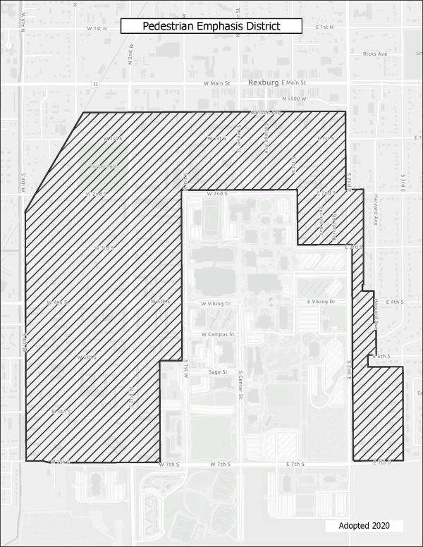
9.02.020 Purpose
9.02.030 Boundary Definitions
9.02.040 Zoning Districts, Zoning Map, Zoning Tables, Land Use Schedules
9.02.050 Applicability Of Rexburg Development Code In Area Of Impact
9.02.060 Legal Description Of Impact Area/Rexburg, Idaho Impact Area With Madison County Legal Description
9.02.070 Enforcement
9.02.080 Referenced Sections
All Zoning Standards apply. (See 3.01-3.06)
Recorded by Ord. 737 Established and Defined a Geographical Area for the Area of City Impact for Rexburg on 9/2/1992
Amended by Ord. 769 Amended Ord. 737 Geographical Area of City Impact for Rexburg on 2/15/1995
Amended by Ord. 770 Add Chapter 10 Area of City Impact; Amended Ord. 725 Adjusted Membership of the Commission, Appeal Process, Fee Agreement on 2/15/1995
Amended by Ord. 880 Amended Ord.769; Amended Geographical Area for Area of City Impact Map for Rexburg on 7/17/2002
Amended by Ord. 939 Amended Ord. 926 Updating the Definition of the Impact Area on 12/14/2005
Recorded by Ord. 1012 Established Definitions and Guidelines for Areas of City Impact within Madison County; Created a Joint Commission on 7/21/2008
Amended by Ord. 1150 Amended Ord. 880; Adopting a Map for Area of Impact on 10/5/2016
The regulations of this Chapter shall apply to the area of city impact and shall supplement the regulations appearing elsewhere in this ordinance. This chapter is being adopted pursuant to Idaho Code 67-6526, and any and all amendments thereto, pursuant to mutual agreement between the City of Rexburg and Madison County.
The purpose of this chapter is to identify an area of city impact, considering such factor as trade area; geographic factors; and areas that can reasonably be expected to be annexed to the city in the future. The intent of this Chapter is to define the geographic area of city impact; to set forth the plans and ordinances, which will be adopted and be applicable to the area of Chapter 65, as set forth by the Idaho legislature.
- The boundaries of the area of city impact are defined by separate ordinance. The boundaries and zoning classifications of the area of city impact are shown on the map entitled “City of Rexburg Impact Area” The map and all information shown thereon are by reference and made a part of this ordinance.
- The method for amending the impact boundaries shall be governed by Idaho Code, Section 67.6526 (d).
- Zoning districts authorized in the Area of Impact comprise two specific categories:
- All existing zones listed in section 3.1 of this ordinance and described in chapters 3-9 hereof.
- Zoning Map. The zoning map shall designate the zoning districts in the Area of City Impact of the City of Rexburg and shall be made a part of this ordinance by reference.
- Compliance with this Section. Infrastructure Plans, subdivision requirements, annexation and Development Agreements shall include provision for installation and continued maintenance of all buffers and compliance with all city and county ordinances applicable within the Area of City Impact.
Any zones, which are located within the area of city impact, shall be subject to all provisions of the Rexburg Development Code and any amendments thereto.
- The following provisions shall apply to the TAG and RR1 zones:
- Description of Land and Livestock. Any landowner having livestock upon lands located within the area of city impact may, prior to February 15, 1995, provide to the Planning and Zoning Commission a description of the land together with a description of the livestock on said lands, which shall include the number of livestock as well as the type of livestock located on said lands.
- Historic Herd Size. The Planning and Zoning Commission shall review the descriptions as submitted by a land owner, and together with the land owner determine a historic herd size for the parcel of land described. The record of historic herd size shall be kept by the City Clerk and shall be preserved for the purpose of determining existing land use on said lands as of February 15, 1995.
- Discontinued Use. In the event a landowner shall discontinue the use and maintenance of livestock on lands described and provided to the Planning and Zoning Commission for a period of five (5) consecutive years, when such use shall not be reestablished, the uses of the premises thereafter shall be in conformity with the regulations of the zone district in which the land is situated; provided, that the use and maintenance of a lesser number of the same general type of livestock on the described lands shall be deemed to conform to the historic herd size as recorded with the City Clerk and will allow the continued recognition of the historic herd size as the current existing land use.
- Expansion or Enlargement of Herd. The expansion or enlargement of a livestock herd shall be allowed only by the granting of a conditional use permit, zone change or variance, as provided by this ordinance and depending upon the particular circumstances and facts involved.
- Description of Land and Livestock. Any landowner having livestock upon lands located within the area of city impact may, prior to February 15, 1995, provide to the Planning and Zoning Commission a description of the land together with a description of the livestock on said lands, which shall include the number of livestock as well as the type of livestock located on said lands.
(Ord. 1150)
“Beginning at a point 300 feet west following the centerline of Highway 33 and the intersection of said centerline with the west section line of section 26, Township 06 North, Range 39 East, being the point of beginning, thence south to the intersection of the south line of the northeast quarter of southwest quarter of Section 02, Township 5 North , Range 39 East, thence east to the intersection of the southwest corner of northeast quarter of southeast quarter of Section 04, Township 5 North, Range 39 East, thence continuing east 422 feet more or less, thence north to the South quarter corner of Sec. 33, Township 06 North, Range 40 East, thence continuing north to the north quarter corner of Section 16, Township 06 North, Range 40 East, thence west along north section lines to where it intersects the west right of way line of North Yellowstone Highway thence northeasterly along said right of way to where it intersects the center section line of section 08, Township 06 North, Range 40 East, thence west along said center section line to the west quarter corner of section 08, thence north along section line to where it intersects the centerline of US Highway 20, thence following centerline of said highway in a southwesterly direction to where it intersects with a line being 300 feet north and parallel to south section line of section 07, Township 06 North, Range 39 East, thence continuing west to a point that intersects with the center line of Section 11, Township 06 North, Range 39 E, thence south approximately 300 feet to south quarter corner of said section 11, thence continuing south to a point where the center section line of section 26, Township 06 North, Range 39 East, intersects with the centerline of Highway 33, thence westerly along centerline of highway 33 to point of beginning.” Note: There is an overlap with Sugar City’s Impact Area in the north half of southwest quarter of Section 08, Township 06 North, Range 40 East.
The City of Rexburg and Madison County authorize the Rexburg Planning and Zoning Commission to be the enforcing agency responsible for enforcing compliance with the provisions of this ordinance within the area of impact.
- Enforcement policies and procedures shall be in compliance with the authorities and duties of the Zoning Administrator, acting as Chief Enforcement Officer for the Commission as provided by chapter 1.
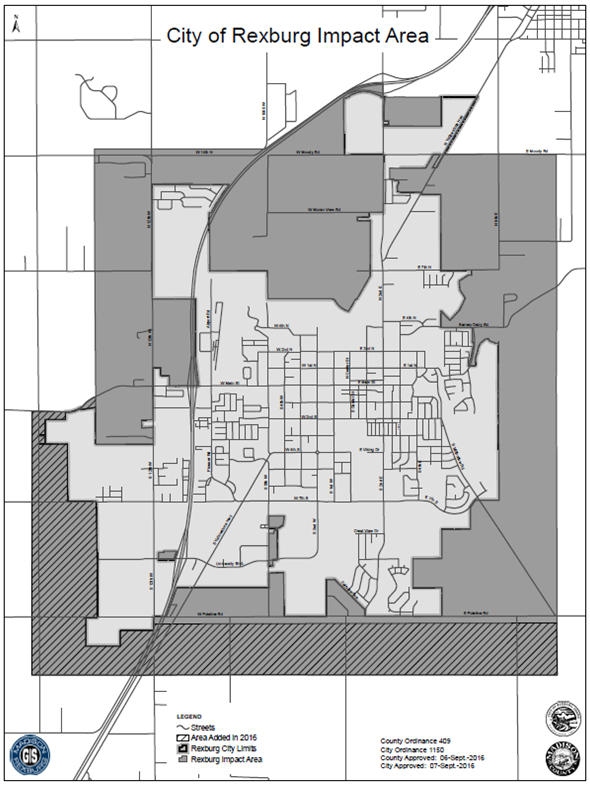
- Impact Area Fees (See subsection 1.02.040.E.6.)
- Appeal of City Impact Matter (See subsection 1.03.100.)
9.03.020 Zoning And Location Requirements
9.03.030 Development Standards
All Zoning Standards apply. (See 3.01-3.06)
Repealed & Reenacted by Ord. 1200 Replaced Ord. 1115 with Amendments; Moved SOB from a zone to an overlay on 2/6/2019
The purpose of this Chapter is to establish a SOB (Sexually-Oriented Business) Overlay Zone that reasonably governs the location of sexually-oriented businesses in order to avoid adverse secondary effects which may result from the operation of such businesses. This chapter shall be construed to protect the governmental interests recognized by this chapter in a manner consistent with protections provided by the United States Constitution and the Idaho Constitution.
- Location. Any sexually-oriented business licensed as an adult business or a semi-nude entertainment business shall be permitted only within the Sexually-Oriented Business Overlay Zone as shown on the Zoning Map of the City of Rexburg.
- Requirements. No sexually-oriented business shall operate within one-thousand (1,000’) feet of any of the following:
- A residential zone boundary line as shown on the Rexburg City Zoning Map.
- The property boundary of any church, public park, public library, or school. And no church, public park, public library or school shall be established within this distance.
- The boundary of any property for which a sexually oriented business license earlier has been issued and has not expired.
- Distance Measurements. The distance from any church, public park, public library, or school shall be measured in a straight line from the nearest point of the line of any property on which a sexually-oriented business is operating, or is proposed to operate, to the nearest residential zone boundary line or property boundary line of any church, public park, public library, or school.
- Standards. Each sexually-oriented business shall be subject to all development standards of the underlying commercial zone in which it is located, including, but not limited to, setbacks, building height, projections, design standards, etc.
- Parking. Off-street parking shall be provided as required by the land use to which the sexually-oriented business is most closely related.
- Signs. Signs for each sexually-oriented business shall be limited to the following:
- All signs shall be flat wall signs.
- The maximum area of all signs shall not exceed one (1) square foot of sign area per (1) foot of building frontage on a public street.
- Banner signs or similar are not permitted.
- Electronic reader board signs or similar are not permitted.
- Flashing lights and any lights that together create motion of any kind are not permitted.
- Displays. No merchandise or pictures of the products or entertainment on the premises shall be displayed in window areas or in any area where they can be viewed from a public sidewalk.
- Deliveries.
- Deliveries of any kind to the establishment shall not be left on the exterior of the building at any time.
- Any merchandise whether exposed of packaged shall not be stored permanently or temporarily on the exterior of the building.
9.04.020 Definitions
9.04.030 General Requirements
9.04.040 Pushcart Vendor
9.04.050 Street Vendor
9.04.060 Mobile-Vending Court
To regulate properties within the City of Rexburg seeking to establish an area for the renting or leasing of space for use by Mobile Vendors.
The following terms are defined in Chapter 2, except where the context clearly indicates that a different meaning is intended and except where an ordinance concerning a particular business contains a specific provision to the contrary:
- Mobile Vending Court
- Mobile Vending Pushcart
- Mobile Vending Structure
- Mobile Vending Trailer
- Mobile Vending Vehicle
- Vendor
- Mobile Vendor Locations
- Vendors: Mobile Court, Pushcart, Street, Daily, Private Property & Temporary
- Business license. (See Municipal Code 6.1.) The City of Rexburg requires a Business License for Mobile Vendors, whether in a Mobile Vending Court or not. (See Municipal Code 6.1.)
- Fees. The current permit, inspection, and license fees for Mobile Vending Courts and Mobile Vendors are set by resolution and may be found in the City of Rexburg Master Fee List.
- All fees shall be paid in advance.
- Clean & Compliant. Mobile vending pushcarts, trailers, and vehicles shall have a clean appearance at all times and comply with all codes.
- Clear Pedestrian Pathway. Where mobile vendors are located on a public sidewalk, a five (5') feet clear pedestrian pathway on the sidewalk must be maintained.
- Customer Service Area. The Customer Service Area shall be on a hard surface.
- Inspection. With the exception of merchandise or food items to be sold, the mobile vending pushcarts, trailers, and vehicles presented for inspection shall be exactly as they will appear when operating, including any food rack.
- Liquid Waste. Liquid waste must be disposed of in a designated facility that must be certified annually.
- Certify. Mobile vendors with liquid waste shall certify that they are disposing of their liquid waste in a manner which conforms to local, state, and federal rules, laws, or ordinances.
- Location. The mobile vending pushcart, trailer, or vehicle must be placed on an area with a hard surface of concrete or asphalt.
- No vendor shall have exclusive right to any location in a public street, nor shall they be permitted to operate in any congested area where their operations may impede or inconvenience the public.
- Mobile Vending Court Required. Four (4) or more mobile vendors on a single parcel will require the building of a mobile vending court. (See Mobile Vending Court.)
- Public Park Vending. (See Municipal Code 12.04.070.)
- Cannot be located:
- Within a midblock, crosswalk area.
- On the portion of a public sidewalk crossed by a public or private driveway or within ten (10') feet of either side of the driveway
- Within any street-corner area (See Site Triangle definition.)
- Within five (5') feet from a perpendicular line drawn to the curb from either side of a doorway.
- In a manner that obstructs the movement or visibility of vehicles using the street or right-of-way
- Directly in front of any single-family, residential structure.
- Mobile Design & Build. Mobile vending pushcarts, trailers, and vehicles must be designed and built meeting normal industry standards and shall be used in a safe manner.
- Non-vending Hours. All pushcarts and street vendors must be removed from public property during non-vending hours.
- Restrooms. A minimum of one (1) restroom facility shall be provided for up to three (3) vendors. For four (4) or more vendors, see Mobile Vending Court.
- Brick and Mortar Agreement. Brick and mortar bathrooms may fulfill the restroom requirement with written permission of the property owner to use the restroom facilities.
- A copy of the written permission of the property owner to use the facilities shall be provided at time of application.
- Portable Toilets w/Hand Sanitation. Portable toilets with hand sanitizing/hand-washing facilities may fulfill the restroom requirement.
- Brick and Mortar Agreement. Brick and mortar bathrooms may fulfill the restroom requirement with written permission of the property owner to use the restroom facilities.
- Seating. No public interior seating is allowed inside a mobile-vending vehicle per current, adopted City of Rexburg International Building Code (IBC) and International Fire Code (IFC) standards.
- Spacing. Spacing between vendor trailers shall be a minimum of five (5') feet.
- Support Equipment & Accessories. Support equipment and accessories must not extend more than four (4') feet from the edge of the mobile pushcart, trailer, or vehicle in any direction on public property, must be securely fastened, and shall not be placed so as to impede pedestrian traffic. (Ex: Umbrellas, canopies, or other covers.)
- Able to Vacate. Mobile vending trailers, structures, and vehicles located on all properties must be capable of moving or of being moved relatively easily within twenty-four (24) hours.
- Construction of a Mobile-Vending Pushcart.
- Braking Mechanism. The braking mechanism on the mobile-vending pushcart shall be affixed in such a manner that it is not readily removable in order to secure the cart when parked on the sidewalk.
- The use of ropes and shocks as the sole, braking mechanism is prohibited.
- Frame. A mobile-vending, pushcart frame must not exceed five (5') feet wide by nine (9') feet long by seven (7') feet tall.
- Wheels. The mobile-vending pushcart must have a minimum of two (2) functional, rubber-tired wheels.
- Braking Mechanism. The braking mechanism on the mobile-vending pushcart shall be affixed in such a manner that it is not readily removable in order to secure the cart when parked on the sidewalk.
- Definition for Pushcart Vendor. (See 9.04.020.)
- Operation of a Pushcart. The mobile-vending pushcart must be able to be pushed by one (1) person.
- Cooking Equipment. Street vendors must have their cooking equipment enclosed and permanently built into the structure of the mobile-vending vehicle or trailer.
- Definition for Street Vendor (See 9.04.020.)
- Legal Parking. Mobile-vending trailers or vehicles must at all times be parked in a legal manner.
- Service. No service shall be conducted to the public on the street-side of the mobile-vending vehicle or trailer.
- Street Vending Locations. (See the following map.)
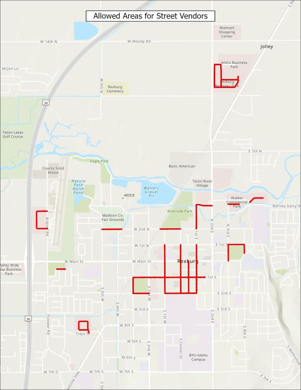
Mobile Vending Cart, Trailer, and Vehicle Standards (Also see Municipal Code 6.1.)
- Purpose. Mobile-Vending Court Areas should provide safe, convenient, and efficient access for vehicles and pedestrians.
- Building Permit. A Building Permit is required when a Mobile-Vending Court is constructed, enlarged, or remodeled.
- Site Plan. A Site Plan shall be submitted for review.
- Convenience Facilities. The property owner shall provide water and sewage systems, sanitary stations, and convenience facilities in accordance with the regulations of the current, adopted City of Rexburg Plumbing Code standards and the State of Idaho Department of Environmental Quality requirements.
- Design.
- Density. The maximum density shall be fifteen (15) vendor sites per acre.
- Lot Coverage. Lot coverage shall be governed by the zone in which the Mobile Vending Court is located.
- Designate Sites. The property must provide designated sites to accommodate the mobile-vending trailer, vehicle, or mobile structure.
- Parking.
- Lighting. Lighting for parking areas shall be directed and, when necessary, shielded so as not to produce direct glare on adjacent properties, and shall comply with the city's lighting ordinance. (See section 3.6.)
- Number of Stalls. Each vending location shall provide parking for at least four (4) vehicles.
- Proximity. Parking must be within three hundred (300') feet.
- Stall Size. Each parking space shall be at least twenty (20') feet in length by nine (9') feet in width. Eighteen (18') feet in length by nine (9') feet in width may be allowed provided the following applies:
- Bumpers. Bumpers are installed or in place.
- Sidewalks. Sidewalk requirements for vehicle overhang are met. (See 9.04.030 Pedestrian Walkways.)
- Surface. All parking lots shall be paved in accordance with subsection 3.04.070 and upon approval by the City Engineer or designee.
- Pedestrian Walkways (Internal). Continuous internal pedestrian walkways, not less than five (5') feet in width, or six (6') feet in width where vehicle overhang will occur, shall be provided from the public sidewalk or right-of-way to the vending sites.
- Connections. Internal pedestrian walkways must connect to public sidewalks.
- Materials. All internal pedestrian walkways shall be distinguished from driving surfaces through the use of durable, low-maintenance, surface materials such as pavers, bricks, or cored concrete to enhance pedestrian safety and comfort, as well as the attractiveness of the walkways.
- Restrooms. There shall be a minimum of one (1) restroom facility for every five (5) vendors, with a minimum of one (1) per Mobile-Vending Court.
- Meet Current Codes. Existing and new restrooms need to meet current, adopted City of Rexburg International Building Code (IBC) and State Plumbing Code standards, and the requirements of the State of Idaho Department of Environmental Quality (D.E.Q.).
- Existing Restrooms.
- Location. Existing restrooms must be located on the parcel or on an adjoining parcel within three hundred (300') feet from the vending location.
- Written Permission. If located on developed property, the owner of the property must give written permission to use the facilities.
- No Existing Restrooms. Permanent restrooms shall be constructed where there is not access to existing restroom facilities or portable restrooms with hand-washing facilities to meet food handling requirements per the Health Department will be permitted.
- Screening. Mobile-Vending Courts must be screened from public or private right-of-way, other uses, and from the adjoining streets to minimize the visual impact of off-street parking.
- Fencing Adjacent to Residential. A six (6') feet high, vinyl or masonry fence in side and back yards shall be required when adjacent to residential. (See Fencing 3.02.110.)
- Front-Yard Buffer. Front-yard setbacks shall be buffered with a minimum ten (10') feet wide landscape strip planted with bushes and trees. (See 3.02.100.B for Buffer Plants.)
- Landscaping. Ten (10%) percent of the lot are shall be dedicated to landscaping and snow storage.
- Landscaping may be interior or may be peripheral and shall include groundcover and trees.
- See Zone Requirements. Screening shall meet the minimum requirements for the zone in which the Mobile-Vending Court is located.
- Setbacks.
- Front Yard. Front-yard setbacks shall be governed by the zone in which the Mobile-Vending Court is located.
- Side Yard. Side-yard setbacks shall be a minimum of five (5') feet from the property line.
- Rear yard. Rear-yard setbacks shall be a minimum of ten (10') feet from the property line.
- Exceptions. When the parcel of a property abuts the side or rear yard of a lot or parcel lying within a residential zone, the yard width shall be equal to that required by the provisions of the residential zone established on the abutting property.
- Signs. (See section 3.5.)
- Site Management. The property owner is responsible for proper control of vendors, site management, removal of garbage and parking of additional vehicles.
- Trash. The property owner shall provide trash receptacles and waste removal for customers and mobile vendors.
- On-Site Dumpsters. On-Site Dumpsters shall be screened in accordance with subsection 3.02.120.
- On-Site Dumpsters. On-Site Dumpsters shall be screened in accordance with subsection 3.02.120.
- Trash. The property owner shall provide trash receptacles and waste removal for customers and mobile vendors.
- Storm Water Retention. All storm-water retention shall follow City of Rexburg Engineering Standards. (See Appendix B.)
- Utilities. Utility service connections are permitted.
Adopted by Ord. 1263 on 1/5/2022
Amended by Ord. 1304 - Signs - Referenced Sections on 12/20/2023
10.2 Lot Line Adjustment
10.3 Infrastructure/Plat Process
10.4 Infrastructure Plans
10.5 Plat Plan
10.6 Short Plat
10.7 Additional Submittals
10.8 Grid Compliance
10.9 Special Developments
All Zoning Standards apply. (See 3.01-3.06)
Recorded by Ord. 444 Regulation of Subdivision of Land in the City; Plat Approval Process; Performance Bonds; Shared Improvements; Facility, Utility and Street Requirements; Public Services be Inspected and Approved before Acceptance on 5/20/1964
Adopted by Ord. 658 Repealed Ord. 444 and Ord. 487; Adopted Subdivision Ordinance on 6/6/1984
Repealed & Reenacted by Ord. 1115 Repealed Ord. 548, 642, 658, 915, 1021, 1027, 1095 and 1026; Development Code; Revised Subdivision Section on 6/25/2014
10.01.020 Definitions
10.01.030 Jurisdictions
10.01.040 Master Plan
The sub-division code for the City of Rexburg, Idaho, establishes requirements for subdividing land within the city and within the city impact area; establishes procedures for processing plats; adopts general design standards; establishes street and utility requirements for new subdivisions; regulates special developments.
The following terms are defined in Chapter 2:
Block Board DEQ Exception, Land Floodway fringe Minor Residential Street Public Works Director Standard Drawings and Specifications Unsuitable Land
The regulations apply to the subdividing of all land within the city and include the following:
- Subdivision of land into three (3) or more parcels for the transfer of ownership or development.
- Publicly Maintained Street Frontage. These lots or parcels created shall front a publicly maintained street unless approved by the Commission and City Council.
- Dedication of a Street or Alley. The dedication of any street or alley through or along any tract of land except where such dedication is initiated at the requirement of a public body.
- Condominium Projects as permitted by Idaho statutes. (See subsection 10.09.020.)
- The re-subdivision of a parcel of land into more than one (1) parcel except as provided in the exceptions listed below:
- Lot Line Adjustment. A lot-line-adjustment which does not reduce the area, frontage, width, depth, or building setback lines to fall below the minimums required by the zoning regulations.
- Large Lots or Agriculture. A subdivision of land into parcels that are larger than forty (40) acres or are lots in a section of land shown on the official U.S. Government General Land Office Township Survey maps including re-subdivisions and designed exclusively for agricultural purposes, and which do not involve any new street dedication of the creation of private easement access to lots or parcels which could otherwise be provided access to a publicly dedicated street. (See definition of agriculture.)
- Settlement of Estate or Court Decree. An allocation of land in the settlement of an estate or a court decree for the distribution of property with the stipulation that the land may not be divided into more than four (4) parcels with a minimum size per parcel to be five (5) acres, or create lots that do not meet the requirements of the zoning regulations.
- Unwilling Sale. The unwilling sale of land as a result of legal condemnation as defined and allowed in the Idaho Code and when the dedication of a right-of-way for public purposes is initiated by a public body.
- Trade or Sale to Straighten Boundaries. The exchange of land for the purpose of straightening property boundaries or by adding land to existing parcels by trade or sale which does not result in change of the present land use or in any way result in land parcels which do not meet existing zoning regulations.
- Large Parcel with Multiple Landowners. If large parcels of land are sold to multiple parties, a Planned Unit Development of the entire area is required.
- Subdivision. If a proposed subdivision is part of a larger area intended for development, a Planned Unit Development of the entire area is required.
- Purpose: Trade or Sale to Straighten Boundaries. The exchange of land for the purpose of straightening property boundaries or by adding land to existing parcels by trade or sale which does not result in change of the present land use or in any way result in land parcels which do not meet existing zoning regulations.
- Lot Line Adjustment. A lot-line-adjustment which does not reduce the area, frontage, width, depth, or building setback lines to fall below the minimums required by the zoning regulations. Land with two (2) legal descriptions stays as two (2) legal descriptions, but the descriptions are amended.
- Lot Combination. The combining of two established lots into a single lot. Land with two (2) legal descriptions will be described with one (1) legal description.
- Lot Split. A single lot divided into two separate lots. Land with a (1) single legal description will be described with two (2) legal descriptions.
- Lot Line Adjustment. A lot-line-adjustment which does not reduce the area, frontage, width, depth, or building setback lines to fall below the minimums required by the zoning regulations. Land with two (2) legal descriptions stays as two (2) legal descriptions, but the descriptions are amended.
- Application. A Lot Line Adjustment application shall be submitted for all lot line changes including lot splits, lot combinations and lot line adjustments via the city's Public Portal.
- Legal Descriptions. Legal Descriptions shall be submitted with the application describing the new lots or new lot configuration.
- Legal Descriptions shall be consistent with a land survey and shall describe the metes and bounds of each lot to close, or consist of previously approved lots.
- Proof of Ownership. Applicant shall submit proof of ownership. If Applicant is not the owner, an Affidavit of Legal Interest, signed and notarized by the owner, shall be submitted.
- Legal Descriptions. Legal Descriptions shall be submitted with the application describing the new lots or new lot configuration.
- Pay Fees. Persons filing an application within the City of Rexburg shall first have paid all fees as established by resolution of the Council.
- Such fees may be reviewed and changed by resolution of the Council at such time as the Council deems necessary.
- Certification. Upon receipt of the application and all required documents as provided herein, the City shall certify the application as complete and shall affix the date of application acceptance thereon.
- Reviews. Once the Application is complete, the City shall transmit a copy of the application and the submitted documents to its various departments and such other agencies that have jurisdiction or an interest in the proposed adjustment for their review and recommendation.
- If no written reply is received from any of the various departments or interested agencies within ten business (10) days from the date of notification, approval of the Plat by such department or agency will be considered granted.
- The application shall be considered by the Zoning Administrator or designee.
- If no written reply is received from any of the various departments or interested agencies within ten business (10) days from the date of notification, approval of the Plat by such department or agency will be considered granted.
- Notify Applicant. Staff shall submit to the applicant within 10 business days, notice of acceptance or needed revisions in writing.
- Revisions. If revisions are requested, applicant shall resubmit documents needing revisions and the review process shall begin again.
- Approval. Applicant shall take approval letter and approved legal descriptions in a deed to Madison County for recording.
- Communicate to City. Recording number is communicated by the Applicant to the City Planning & Zoning office to finalize permit.
10.03.020 Subdivision Submittal
10.03.030 Subdivision Review
10.03.040 Subdivision Consideration
10.03.060 Bonding
10.03.070 Request For Mylar
10.03.080 File With County Recorder
10.03.090 Building Permit
10.03.100 As-Built Plans
10.03.110 D.E.Q Prior To Construction
10.03.120 Plat Amendment (Reserved)
Before filing an application for a Plat, the Applicant will submit a concept drawing and any additional data to communicate intentions and plans and meet with the Ready Team. The Ready Team will communicate any pertinent information to the Applicant. (See Subsection 1.02.020.)
Amended by Ord. 1241 on 11/18/2020
Amended by Ord. 1248 on 2/17/2021
Amended by Ord. 1298 Chapter 10 Subdivisions - April 2023 on 6/7/2023
- Zone Changes. Before platting of the development, all required zoning changes shall be obtained.
- The sub-divider may cause the subdivision, or part thereof to be surveyed and a Plat prepared.
- Application. If the sub-divider elects to proceed with the platting process, he shall file with the City Planning and Zoning Office, one (1) digital copy of the Infrastructure Plan and one (1) digital copy of the Plat in .pdf AutoCAD formatwith Proof of Ownership, Covenants, Conditions and Regulations, the Landscaping Plan and Drainage Calculations. A Traffic Study should also be submitted if it is required by the City Engineer. (See section 10.7.)
- Infrastructure Plans. The Infrastructure Plan shall include the plans and specification for all proposed improvements that are required for that portion of the subdivision included in the Plat as required for this Ordinance and all others required by the City Engineering Department (See Section 10.4.)
- Plat. The sub-divider shall file the Plat, bearing all required certificates, acknowledgements and signature blocks of the owner, surveyor, reviewing surveyor and others as determined by the Planning & Zoning department. (See subsection 10.05.020.)
- The Plat must contain a statement of dedication of all streets, alleys, drainage ways, pedestrian ways, and other easements for public use by the person holding title of record and by persons holding title as vendees under land contract. lands dedicated are mortgages, the mortgagee shall sign the plat.
- Acknowledgement. Execution of dedication shall be acknowledged and certified by a notary public.
- The Plat must contain a statement of dedication of all streets, alleys, drainage ways, pedestrian ways, and other easements for public use by the person holding title of record and by persons holding title as vendees under land contract. lands dedicated are mortgages, the mortgagee shall sign the plat.
- Proof of Ownership. A current title report or other evidence acceptable to the City showing proof of ownership of the tract of land being platted shall be part of the application submission.
- Covenants, Conditions and Regulations (CC&R's) shall be submitted with the Plat.
- Landscape Plan. (See 10.07.030.)
- Pay Fees. Persons filing a subdivision plat within the City of Rexburg shall first have paid all fees as established by resolution of the Council. Such fees may be reviewed and changed by resolution of the Council at such time as the Council deems necessary.
- Incomplete Application. If the application is determined to be incomplete, the Zoning Administrator or designee shall provide the applicant with a description of the additional materials required to make the application complete.
- Certification. Upon receipt of the Plat and all required data as provided herein, the City shall certify the application as complete and shall affix the date of application acceptance thereon.
Amended by Ord. 1181 Amended Ord. 1115; Number of copies for Preliminary Plat submittal on 2/21/2018
Amended by Ord. 1241 on 11/18/2020
Amended by Ord. 1248 on 2/17/2021
Amended by Ord. Ord 1337 Subdivision Names - May 2025 on 10/1/2025
- City Engineering Review. All details for the Infrastructure Plan review as it pertains to the Plat shall be completed prior to submission to other departments for Staff Review for the Plat.
- Design and Installation. All water system and sewer system design and installation is to be done in accordance to the requirements of the Department of Environmental Quality (D.E.Q.) and adopted City Engineering Standards.
- The City Engineering Department shall check the Plat for conformity to the Infrastructure Plan. The City Engineer will determine if the street, water, sewer, drainage and drainage pre-treatment, storm water detention, and other similar facilities in the area surrounding the development and in the city are or will be adequate to provide for the health, safety and welfare for the development's population densities and the type of development proposed, taking into consideration existing and projected future demands on those facilities.
- Nonconformance. In the event the Plat does not substantially conform to the Infrastructure Plan, the sub-divider shall be required to resubmit the Plat.
- Will Serve Letter. The City will provide a "Will Serve Letter" for the developer after the Infrastructure Plans have been reviewed and approved by the City Engineer.
- Development Agreement. The sub-divider shall work with the City Engineering Department to develop a Development Agreement for review with the Infrastructure Plans. Conditions shall be established for:
- Requirements for the extent and manner in which roads shall be created and improved
- Water and sewer and other utility mains; piping connections, or other facilities shall be installed.
- Department Staff Reviews. Upon approval of the Infrastructure Plans, and at least twenty-one (21) prior to the scheduled presentation before the Commission, the City shall transmit a copy of the application and the Plat to its various departments and such other agencies that have jurisdiction or an interest in the proposed subdivision for their review and recommendation.
- If no written reply is received from any of the various departments or interested agencies within ten business (10) days from the date of notification, approval of the Plat by such department or agency will be considered granted.
- Possible Departments and Agencies:
- City Engineer
- City Planning and Zoning Department
- County Commissioners
- City Council
- Fire Department
- GIS Department
- Public Works Director
- State Highway Department
- Utility Companies
- Irrigation District (if subdivision abuts or includes a canal or ditch)
- Other departments or agencies as necessary
- County Surveyor Review. The Plat shall be reviewed by the County Surveyor for conformance to County codes. The County Surveyor signs the Plat as the Examining Surveyor.
- The County charges a separate fee for the County Surveyor review.
- Commission Action. The Plat shall be placed on the Commission agenda for consideration at the next available regular meeting.
- Review. The commission shall review the application and comments from the review agencies for compliance to the City's Comprehensive Plan, Development Code, and applicable ordinances. The Commission shall determine if further action will be necessary to complete the review and make recommendations to City Council.
- Amendment. If the Commission determines that an amendment must be made to the Comprehensive Plan and/or the Zoning Ordinance to approve the application, the Commission shall follow the procedures detailed in Idaho Codes 67-6509.
- Recommendation. The Commission will recommend to City Council the Plat be approved, approved conditionally, or disapproved within thirty (30) days after the date of the meeting at which the Plat is first considered.
- The Commission, will then send a copy of the Plat and the Commission's findings or Reasons for Decision to the City Council.
- Reasons for Decision. The reasons for such decision shall specify:
- the ordinance and standards used in evaluating the application
- the reasons for approval or denial; and
- the actions, if any, that the applicant could take to gain approval of the proposal.
- Council Action. Upon receipt of the Plat and related documents, and all other data as required herein, the Council shall thereafter place the Plat on their next available agenda for consideration at a regular meeting held not less than fourteen (14) days upon the report of the Commission.
- If said Plat conforms to the requirements of this Ordinance and the Idaho Code, the Council shall consider the approval of the Plat.
- Testimony. The Council may hear testimony of the representatives of the Commission and witnesses, including interested citizens affected by the proposed subdivision.
- Findings. The Council shall base its findings upon the report and testimony presented before it and declare its findings. It may sustain, modify, or reject the recommendations of the Commission, and make such findings as are consistent with the provisions of this ordinance and the Idaho Code. The reasons for such decision shall specify;
- the ordinance and standards used in evaluating the application
- the reasons for approval or denial; and
- the actions, if any, that the applicant could take to gain approval of the proposal.
- Dedications Accepted. At the time of approval and recording of the Plat, the Council shall accept the dedications shown thereon. The Council shall also, as a condition precedent to the approval of any plat, require the sub-divider either to improve or agree to improve the streets and all other public improvements by furnishing a Surety Bond or satisfactory agreement in accordance withaccordancewith Standard Drawings and Specifications and the Infrastructure Plan as defined in the Development Agreement.
- To complete the acceptance of any dedication of land, the owner shall furnish to the Council, a deed conveying such lands to the City.
- The City will record the deed with the County Recorder.
- The Council shall make such findings as are consistent with the provisions of this Ordinance and the Idaho Code. The Reasons for such Decision shall include:
- the Ordinance and standards used in evaluating the application
- the reasons for approval or denial; and
- the actions, if any, that the applicant could take to gain approval of the proposal.
- To complete the acceptance of any dedication of land, the owner shall furnish to the Council, a deed conveying such lands to the City.
- Reasons for Decision. The reasons for such decision shall be stated in writing, a copy of which shall attached to one (1) copy of the Plat and returned to the sub-divider.
Prior to recording the Plat, the sub-divider shall file with the City Clerk a surety bond, or other acceptable guarantee, to ensure actual construction of such improvements as submitted and approved.
- The improvements when covered by a surety bond, shall be constructed within two (2) years from the date of recording of the Plat; provided, however, the City may extend the period one (1) year upon showing of just cause by the sub-divider.
- Such surety bond shall be one-hundred-ten percent (110%) of the estimated cost of the improvements as determined by the City.
- A copy of certification shall be forwarded to the City Clerk if a surety agreement has been executed by the sub-divider.
- Thereafter, if a surety agreement has been executed by the sub-divider, the City Clerk shall thereafter release seventy-five (75%) percent of said surety or guarantee upon application of the sub-divider.
- The final twenty-five (25%) percent of the surety will remain in effect for a twelve (12) month warrantee period.
- If no problems are outstanding at the end of the warrantee period, the City Clerk will release the final amount upon written request by the developer.
Once all revisions from staff reviews, County Surveyor, Commission and/or Council amendments have been made to the Plat, the City of Rexburg Staff will request the final Mylar be printed. The final Mylar shall show all revisions.
- All plats to be offered for recording shall be on transparent tracing(s) that show all pertinent information that was approved on the Plat.
- The approved Plat is to be recorded on clear Mylar silver emulsion with an overall dimension of eighteen (18”) inches by twenty-seven (27”) inches. (Idaho Code 50-1304)
- Required Certifications.
- Signature of the following show approval or completion. Please seek signatures in the order they are listed.
- Professional land surveyor – Surveyor shall state on plat that plat is correct, accurate, and monuments described have been located, installed, and described
- Examining Land Surveyor (Madison County)
- Sanitary restriction being lifted (Health Department after approval by D.E.Q.)
- Treasurers Certification of taxes paid
- City Planning & Zoning Administrator
- Certification of plat approval by the City Engineer
- Certificate of approval by the City Clerk
- Certificate of approval by City Council (Mayor)
- Recordation by County Recorder
- Signature of the following show approval or completion. Please seek signatures in the order they are listed.
- Development Agreement. Before the Plat will be signed by the City, the Development Agreement shall be executed and the Development Agreement fees shall be paid.
Amended by Ord. 1241 on 11/18/2020
Amended by Ord. 1298 Chapter 10 Subdivisions - April 2023 on 6/7/2023
The Plat shall be filed with the County Recorder within six (6) months after approval by the Council, otherwise such approval shall become null and void unless an extension of time is applied for and granted.
- Communicate to City. Recording number is communicated to the City Planning & Zoning office to finalize permit.
- Extension. An extension of a six (6) month time period may be granted, for good cause, by the City Council.
- Extension Request. A written extension request must be received by the Planning and Zoning Administrator prior to the expiration deadline in order to be valid.
- Consistent with Zoning. Also, provided that the extension will be consistent with then-existing city zoning ordinance requirements, in relation to then-existing conditions.
- Expiration. If an approved Plat expires, whether as to the entire area proposed for development or as to yet unbuilt portions of development, then a complete new application must be submitted prior to reconsideration.
- An application for reconsideration shall be treated as an original application and shall be subject to all of the procedures of this chapter.
Amended by Ord. 1241 on 11/18/2020
Amended by Ord. 1248 on 2/17/2021
Amended by Ord. 1308 - Plat Recording Deadline - August 2023 on 2/21/2024
Once a subdivision has been recorded with Madison County, an Applicant may apply for a Building Permit. (See 1.04.070.)
Prior to acceptance by the City of any improvements installed by the sub-divider, two (2) sets of prints of the approved as-built plans and specification shall be certified by the sub-divider’s engineer and filed with the City.
- The as-built drawing shall also be submitted in AutoCAD format, and shall show any deviations from the approved construction drawings.
- Within thirty (30) days after completion of improvements and submission of “as-built” plans and specifications, the City shall certify completion and acceptance of construction and shall transmit a copy of said certification to the sub-divider.
- Improvements. All water system improvements are to be approved by D.E.Q. prior to any construction.
- The sub-divider is responsible for submitting the design to D.E.Q. for approval.
- Approval Letter. A copy of the approval letter from D.E.Q. for the final design shall be submitted to the City Engineer by the sub-divider.
- "Will Serve Letter." The City will provide a "Will Serve Letter" to the developer after the plans have been revieed and approved by the City Engineer.
10.04.020 Responsibility Of Sub-Divider
10.04.030 Required Improvements For Infrastructure
10.04.040 Water, Wastewater, Storm, Irrigation
10.04.050 Streets Layout
10.04.060 Street Identification
10.04.070 Street Standards
10.04.080 Typical Roadway Sections
10.04.090 Street Lighting
10.04.100 Utility Locations
10.04.110 Pedestrian Ways
10.04.120 Public Sites, Open Spaces, And Natural Features
- Development Master Plan. If the proposed subdivision is part of a larger area intended for development, a Development Master Plan of the entire area is required.
- Sub-Divider Responsibility. All required improvements such as streets, seal coating, alleys, utilities, street lighting, drainage, easements, and other facilities which are required as a condition to plat approval shall be the responsibility of the sub-divider and shall meet City specifications and standards of construction.
- Registered Engineer in Idaho. Plans for the improvements herein required shall be prepared by a registered engineer in the State of Idaho.
- Engineered Plans. Infrastructure Plans must be done by an Idaho Registered Engineer, be approved for individual subdivisions by the City Engineer, must comply with the adopted Design Standards and Specifications of the City, and must be approved by the Departments of Environmental Quality (D.E.Q.) and District 7 Health.
- Standard Drawings and Specifications. The following will need to be in compliance with the adopted Standard Drawings and Specifications of the City. The following improvements shall also be approved for individual subdivisions by the City Engineer.
- Pedestrian ways
- Public Sites, Open Spaces, and Natural Features
- Water Systems
- Fire Hydrants
- Wastewater Systems
- Storm Water Disposal
- Monuments
- Curb, gutter, and street improvements
- Street signage
- Street lighting
- An Infrastructure Plan shall be drawn to scale shall show the following:
- the actual dimensions and the shape of the lot to be built upon;
- the exact size and location of existing buildings on the lot, if any;
- the exact location and dimensions of the proposed building, sidewalk, driveway, carport, parking area or any other structure or alteration;
- the location, layout and access of proposed on-site parking;
- Number and dimensions of off-street parking spaces and loading berths
- the location and type of landscaping, fencing and screening proposed on the lot;
- Proposed water and sewer facilities
- Existing and proposed easements
- All other data indicated in Section 10.4.
- Approval Process.
- Engineer Designed. All system designs are to be completed by an Idaho registered Engineer.
- Design and Installation. All water system and sewer system design and installation is to be done in accordance to the requirements of the Idaho Department of Environmental Quality (D.E.Q.) and adopted City Engineering Standards.
- Plans for proper and adequate provisions including type, extent, location, and capacity of facilities shall be made for disposal of wastewater, water, supply, and storm water shall be approved for individual subdivisions by the City Engineer.
- Culinary Water Service. Proper and adequate provision shall be made for culinary water service to each lot.
- Sub-divider Responsibility. It shall be the responsibility of the sub-divider to furnish such evidence as may be required relative to the design, operation, volume, and quality of water supply and facilities proposed including pipe size, pipe materials, location, valve location, hydrant location and any special requirements.
- Location. Water pipelines are to be located per current City Engineering Standards.
- Water lines are to be located at approximately the center of new residential lots.
- Commercial Developments. The location and size of service lines for commercial developments are to be approved by the City Engineer.
- Sub-divider Responsibility. It shall be the responsibility of the sub-divider to furnish such evidence as may be required relative to the design, operation, volume, and quality of water supply and facilities proposed including pipe size, pipe materials, location, valve location, hydrant location and any special requirements.
- Wastewater Disposal.
- Sub-divider Responsibility. It shall be the responsibility of the sub-divider to furnish such evidence as may be required relative to the design and operation of the sanitary sewage facilities proposed including pipe size, manhole location, pipe slope and information on any required pump stations.
- Wastewater. Wastewater pipelines are to be located per current City Engineering Standards. Exceptions with approval of City Engineer.
- Storm Water Management.
- It shall be the responsibility of the sub-divider to furnish the City such evidence as may be required relative to design and operation of any storm water system proposed and how storm water will be disposed of with supporting calculations.
- Topography. Topography by contours or other method approved by the City Engineer and shown on the same map as the Infrastructure Plan. Contour intervals shall be such as to adequately reflect the character and drainage of the land. In most cases, the contour interval will be two (2') feet.
- Water Features and Wetlands. Location and extent of all water features and known areas of wetlands, and the direction of their flow.
- On-Site Detention. On-site detention will be required in most locations. In areas where it is not feasible to connect to or extend existing piped storm water systems to new development, all storm water is to be retained and disposed of on-site.
- Storm Drain System. Piped storm drain systems for city streets are to be installed within the right-of-way and within the paved portion of the street section unless otherwise approved by the City Engineer.
- Infiltrators. If local-non-piped-storm-water-management systems are used, the infiltrators are to be installed in the planting strip or as determined by the City Engineer.
- On site storm retention for the parcel may not use the right-of-way for storage or conveyance to another portion of the parcel.
- Required items B, C & D above shall consider and include Health Department and Soil Conservation Service data and requirements, which the sub-divider has accumulated with the Infrastructure Plans.
- Fire Hydrants. Fire protection shall be included in the design of the project to meet the requirements of the City Engineering Standards, this ordinance, and International Fire Code requirements.
- Fire Hydrants. The location of fire hydrants required to serve the subdivision shall be approved by the City and meet the requirements of this section.
- Hydrants. A minimum ten (10’) feet by ten (10’) feet level area will be required for all hydrants.
- Profiles. Profiles of sanitary sewer, street drainage, drainage pre-treatment, storm water detention and water distribution systems, showing pipe size and location of valves and fire hydrants, all to conform to city and state standards.
- Irrigation Management. The sub-divider shall indicate how site landscaping irrigation will be managed and provided.
- Water Rights and Shares. All water rights or shares that have been historically linked to the development property shall be used for site irrigation or surrendered to the city.
- Water Rights and Shares. All water rights or shares that have been historically linked to the development property shall be used for site irrigation or surrendered to the city.
Recorded by Ord. 248 Establish regulation of City Sewer System on 5/24/1920
Amended by Ord. 260 Amended Application Process and Fees for Sewer Connections on 10/6/1920
Recorded by Ord. 309 Established Water Rates and Charges for City Water on 10/26/1931
Recorded by Ord. 316 Required Installation of Water Meters on 3/28/1934
Recorded by Ord. 317 Application for City Water Connection established and Fees amended on 4/25/1934
Amended by Ord. 356 Amended Application Process and Fees for Sewer Connections on 8/21/1946
Amended by Ord. 399 Amended Ord. 322 Sect.1 Increase Water Rates; Amend Ord. 309 Sect.4 States when Water Payments are Due on 4/18/1956
Recorded by Ord. 431 Amend Charges for City Sewer Services on 12/19/1962
Amended by Ord. 555 Amended Sect.1 of Ord. 401: Amending Water Fees on 7/17/1974
Amended by Ord. 624 Amend Sewer Rates on 9/3/1980
Repealed & Reenacted by Ord. 629 Repealed Sect.II of Ord. 399; Amended Ord. 431 Sect.4 for Billing and Collection for Water/Sewer Services; Amend Ord. 322 Sect.7 Deposit for Application and Refund procedures for discontinuance or termination of those services on 11/5/1980
Recorded by Ord. 618 Requiring Back Flow Prevention Devices on 5/20/1981
Recorded by Ord. 638 Require mandatory connection to City Sewer inside City Limits; Rules for Connection, Enforcement on 10/7/1981
Repealed & Reenacted by Ord. 645 Repeals Ord. 638 Mandatory Sewer Connection, Rates, Rules for Connection, Billing Periods and Procedures for delinquent accounts or discontinuance of water services, Enforcement on 2/17/1982
Adopted by Ord. 660 Pretreatment for Existing and New Sources of Pollution on 7/18/1984
Amended by Ord. 711 Amends Ord. 645 Sect.IV Sewer Connection fees; Fees to be set by Resolution on 9/19/1990
Recorded by Ord. 735 Provide for Construction and Installation of Improvements to Wastewater Collection and Treatment System; Bonds on 9/2/1992
Amended by Ord. 749 Amended Ord. 555 Sect.I Water Base Rates and Usage Rates to be set by Resolution on 9/1/1993
Recorded by Ord. 760 Charge of $10/lineal foot of Utility Line for property abutting either side of a water or sewer line in addition to hook-up fees or other charges required; Permit to connect to any water or sewer main constructed at city expense; reimbursement for stub-outs for private property; Fees by Resolution on 9/7/1994
Amended by Ord. 772A Amended Ord. 645 to Redefine the Method for determining the surcharge for excessive strength on 6/7/1995
Adopted by Ord. 800 Adopted Wastewater Ordinance; Repealed all Ordinances in Conflict on 11/19/1997
Repealed & Reenacted by Ord. 1016 Repealed Ord. 800; Approved Wastewater Ordinance on 1/17/2009
Repealed & Reenacted by Ord. 1093 Repealed Ord. 618; Cross-Connections to City Water; Required Backflow Prevention Devices; Cross Connections for Specific Types of facilities; Types of Protective Devices and Manner of Installation; Inspection and Testing of Backflow Devices on 3/20/2013
Amended by Ord. 1188 Amended Ord. 1115; Water and wastewater pipelines are to be located per current City Engineering Standards. on 7/18/2018
Amended by Ord. 1241 on 11/18/2020
- Street Plans. The sub-divider shall show road widths, typical sections and pavement structure and street system plans, including:
- Central line profiles showing finished grades of all streets;
- Cross sections of proposed streets showing widths of roadway, curbs, locations and width of sidewalks and location and size of utility mains;
- Street layout, including classification, location, width and proposed names of public streets, alleys, pedestrian ways and easements; connections to adjoining platted tracts shall also be shown.
- Show right-of-way lines, radii, points of tendency and central angles of all curvilinear street and alleys and radii of all street line intersections. (Idaho Code 50-1303)
- Show connections to adjoining platted tracts.
- Curb and Gutter. Curb and gutter per current City Engineering Standards.
- P.U.D. Only. The estimated cost of street, sewer, drainage and drainage pre-treatment, storm water detention, water, and other public infrastructure improvements within the planned unit development.
Amended by Ord. 1188 Amended Ord. 1188; Required Water Shares and Traffic Study for any development that has a potential to significantly impact traffic flow to Proposed Utility Methods for a Preliminary Plat on 7/18/2018
Amended by Ord. 1241 on 11/18/2020
- New Streets.
- All new streets constructed shall conform to existing and planned streets, in topographical conditions, arrangement, character, extent, width, grade, and location for public convenience and safety in relation to the proposed uses of the land to be served by such streets.
- Transportation Master Planning. New streets are to be developed to conform to any adopted transportation system master planning.
- Cul–De-Sacs. The city engineering department shall approve all cul-de-sac streets.
- No cul-de-sacs shall be longer than six-hundred (600’) feet.
- The cul-de-sac shall terminate with a turnaround area with a minimum back of curb radius of forty-five (45’) feet and a right-of-way radius of fifty-seven (57’) feet.
- Dead-End Streets. Dead End Streets are intended for future extensions in development of adjacent lands.
- A dead-end street serving more than four (4) residential lots shall provide, by easement, a temporary turning circle with a forty-five (45’) foot radius or other acceptable design to accomplish adequate access. The turn-around is to be graveled and graded for vehicular use.
- Frontage Streets. Frontage Streets are intended where a subdivision abuts or contains an existing or proposed arterial street, railroad, or limited access highway.
- Because of the need to control the number of accesses to these roads, the developer may be required to back lots onto the road or to provide a parallel access road.
- Half - Streets. Half Streets are not allowed.
- Exceptions: The Council may accept a partial street dedication when such street forms the boundary of the proposed subdivision and is deemed to be necessary for the orderly development of the neighborhood, and provided the Council finds it will be appropriate to require the dedication of the remainder of the right-of-way when the adjoining property is developed.
- When a half-street exists adjoining a proposed subdivision, the remainder of the right-of-way shall be dedicated.
- Where a half-street dedication is constructed, they shall be of a width to be fully functional as a city access street. The minimum acceptable pavement width is twenty-six (26’) feet or as required by the City Engineer.
- Exceptions: The Council may accept a partial street dedication when such street forms the boundary of the proposed subdivision and is deemed to be necessary for the orderly development of the neighborhood, and provided the Council finds it will be appropriate to require the dedication of the remainder of the right-of-way when the adjoining property is developed.
- Local Residential Streets. Local Residential Streets shall be designed to discourage through traffic use.
- Loop Street. Loop streets shall be limited to a maximum length of twelve hundred (1200) feet measured along the centerline of a street from centerline section to centerline section or upon approval of the City Engineer.
Amended by Ord. 708 Amended Ord. 658 Chap.3 Sect.3.2 Para.5; Radius of Cul-de-sac Streets 50' on 5/16/1990
Amended by Res. 2002-05 Amended Cul-de-sac radius from 50' to 57' on 6/5/2002
Amended by Ord. 1188 Amended Ord. 1115; New Streets to conform to adopted Transportation Master Plan; Minimum acceptable pavement is 26' for Half Streets or as required by City Engineer; Dead end streets with 4 Residential Lots provide a turning circle; Loop streets maximum length of 1200' along centerline of a street from intersection to intersection. on 7/18/2018
Amended by Ord. 1241 on 11/18/2020
All streets shall have curbs and gutters, sidewalks, and asphalt paving per City Engineering Standards. In rural residential zones, the requirement for curb and gutter may be eliminated with approval of the City Engineer and in compliance with the approved typical roadway sections. (See subsection 10.04.080.)
- Intersections and Alignments
- Prohibited Streets. Streets with centerline offsets of less than one hundred twenty-five (125’) feet are prohibited without City Engineer prior approval.
- Avoid These Intersections. Street intersections with more than four (4) legs and Y-type intersections where legs meet at acute angles shall be avoided.
- Right Angles. Streets shall be planned to intersect as nearly as possible at right angles, but in no event at less than seventy (70°) degrees. A street intersecting an arterial street shall do so at less than eight-five (85°) degrees.
- Connecting Curve. Where any street deflects at an angle of five (5°) degrees or more, a connecting curve shall be required having a minimum centerline radius of three hundred (300’) feet for arterial and collector streets and one hundred twenty-five (125’) feet for local streets.
- Between Reverse Curves. A tangent at least one hundred fifty (150’) to two hundred (200’) feet long shall be provided between reverse curves on arterial and collector streets.
- Seal Coating. The developer is required to have all streets or roads seal coated as per city standards within two (2) years of acceptance.
- Bond or Security. The developer shall file with the city a bond or other acceptable security to provide payment of the seal coating.
- City Seal Coating Project. Arrangements may be made to have the seal coating incorporated within a city seal coating project if coordination and payment arrangements are made with the City Engineering Department prior to bidding the seal coating project.
- Paving. Paving must comply with approved city typical street sections.
- Alternate paving sections will be considered if substantiated by an in depth engineering analysis by an Idaho professional engineer
- Right-of-way & Number of Moving Lanes. For right-of-way width and number of moving lanes, see current Engineering Standards, as specified by IDAPA 39.03.42. (See subsection 10.03.090.)
- Intersection Frequency. Intersections shall be limited to as few points as possible.
- Street signs and Traffic Control Signals. Street name signs and traffic control signs shall be installed by the City in appropriate locations at each intersection in accordance with local standards.
- A fee shall be charged to the sub-divider to reimburse the City for its cost of such signing.
Amended by Ord. 1188 Amended Ord. 1115; Right of Way and Number of Moving Lanes per current City Engineering Standards; All streets shall have curbs and gutters, sidewalks and asphalt per City Engineering Standards. Concrete Sidewalks on both sides of dedicated streets; Sidewalks set back from curb and street lights per City Engineering Standards. on 7/18/2018
Amended by Ord. 1241 on 11/18/2020
| MAJOR ARTERIAL | |
| Permits rapid and relatively unimpeded traffic movement throughout the city to carry high volumes of inter and intra traffic which connects the major land use elements, as well as, communities with one another. The major function is to serve through traffic and secondary function is to serve abutting property. *Major Arterial streets are shown on the approved Transportation Plan. | |
| ALIGNMENT | GRADES |
| Horizontal: 700’ minimum radius at centerline, 930’ preferred Vertical: Minimum length = K * (algebraic difference in rate of grade) | 0.3%-0.6% *0.7% may be considered for unique, short distances. |
| INTERSECTIONS | PLANNING |
| 1. Intersections will be “T” type at grade design unless prior approval is obtained from the City Engineer 2. Intersections shall be no less than specified by IDAPA 39.03.42. 3. Median Cuts. Median cuts will not normally be permitted except at major or significant street intersections as approved by City Engineer. | 1. Should be spaced approximately one (1) mile apart in suburban areas and a few blocks apart in areas of high population density and intense land usage. 2. Should not bisect neighborhoods but act as boundaries between them. 3. Abutting Properties. Abutting properties shall not face on the roadway unless separated from it by a frontage road. 4. Bicycle. On-street bicycle travel is not allowed unless no alternative routes are available. |
| CURB, GUTTER, SIDEWALK | Curbs, gutter, and sidewalks required per current City Engineering Standards |
| PARKING | On-street parking prohibited |
| PAVING | Determined by a full soils investigation, traffic study, and a pavement design completed by an engineer licensed in state of Idaho and approved by City Engineer. |
| TRAFFIC CONTROL | Traffic control devices and channelization |
| MINOR ARTERIAL | |
| Permits rapid and relatively unimpeded traffic movement throughout the City and carry high volumes of inter and intra traffic which connects the major land use elements | |
| ALIGNMENT | GRADES |
| Horizontal: 700’ minimum radius at centerline Vertical: Minimum length = K * (algebraic difference in rate of grade) | 0.3% - 0.6% *0.7% may be considered for unique, short distances; Flatter slopes may be approved. |
| ACCESS | PLANNING |
| 1. Intersections will be “T” type at grade design unless prior approval is obtained from the City Engineer 2. Intersection and curb cuts shall be limited | 1. Spaced approximately one (1) mile apart in the suburban areas of the City to a few blocks in areas of high population density and intense land usage. 2. Should not bisect neighborhoods 3. Bicycle. Utilitarian bicycle travel can be accommodated with fourteen (14’) travel lanes on designated streets. |
| CURB, GUTTER, SIDEWALK | Curbs, gutter, and sidewalk required as per City Engineering Standards |
| PARKING | On-street parking prohibited |
| TRAFFIC CONTROL | Traffic control devices and channelization |
| RESIDENTIAL COLLECTOR | |
| Designed to serve the local needs of the neighborhood and provide direct access to abutting properties. All should have an origin or a destination within the neighborhood. | |
| ALIGNMENT | GRADES |
| Horizontal: 300’ - 450’ radius at centerline Vertical: Minimum length = K * (algebraic difference in rate of grade) | 0.3% - 0.7% |
| ACCESS | PLANNING |
| 1. Direct access to residential properties by way of curb cuts 2. Intersections are at grade | 1. Should be designed to discourage through neighborhood traffic 2. Curvilinear and loop streets are desirable 3. Bicycle. Bike travel can be accommodated with 14’ outside travel lanes |
| CURB, GUTTER, SIDEWALK | Sidewalks will be detached from a standard approved curb and gutter section, with location and width according to current City Engineering Standards. |
| PARKING | On-street parking allowed on both sides of the street unless otherwise directed by the City Engineer |
| RESIDENTIAL STREET | |
| Designed to serve the local needs of the neighborhood and provide direct access to abutting residential properties. All traffic should have an origin or destination within the neighborhood. | |
| ALIGNMENT | GRADES |
| Horizontal: 200’ radius at centerline Vertical: Minimum length = K * (algebraic difference in rate of grade) | 0.3% - 0.7% |
| ACCESS | PLANNING |
| 1. Intersections are at grade. 2. Direct access to abutting properties by way of curb cuts or drive-overs (ramp-type) curbing is allowed. | 1. Designed to minimize through traffic 2. Curvilinear and loop streets are desirable 3. In subdivision design, streets are discouraged from intersections with major and secondary arterial streets |
| CURB, GUTTER, SIDEWALK | Sidewalks will be detached and separated by a planter strip in compliance with current City Engineering Standards. |
| PARKING | On-street parking allowed on both sides of the street |
| RURAL RESIDENTIAL | |
| Provide direct access to abutting single-family residential properties or cul-de-sacs having a length of no greater than six-hundred (600’) feet. | |
| ALIGNMENT | GRADES |
| Horizontal: 150’ minimum radius at centerline Vertical: Minimum length = K * (algebraic difference in rate of grade) | 0.4% - 0.7% *Grading plans are required to be approved by City Engineering Department. |
| ACCESS | PLANNING |
| 1. Intersections are at grade. 2. Direct access to residential properties is allowed. | 1. Designed as a short loop or cul-de-sac street only. 2. Should not intersect major arterial streets |
| CURB, GUTTER, SIDEWALK | See current City Engineering Standards; Sidewalks should be detached |
| PARKING | On-street parking may or may not be allowed on either side of the street |
| PAVING | A pavement width of thirty-four (34’) feet is allowed on minor rural residential streets which contain no more than fifty (50) single-family lots. (See current City Engineering Standards.) |
| STORMWATER | Storm water management is to be designed to maintain the drainage upon each lot. |
| INDUSTRIAL/COMMERCIAL STREET | |
| Designed to serve facilities within industrial commercial areas and to connect such areas with major arterial and collector streets | |
| ALIGNMENT | GRADES |
| Horizontal: 300’ radius at centerline Vertical: Minimum length = K * (algebraic difference in rate of grade) | 0.3% - 0.6% |
| ACCESS | PLANNING |
| 1. Direct access to abutting commercial properties by way of curb cuts 2. Intersections are at grade (0.5% minimum) | Only local industrial commercial traffic should be encouraged |
| CURB, GUTTER, SIDEWALK | Sidewalks will be detached from the curb where required |
| PARKING | On-street parking may be permitted on both sides of the street |
| PRIVATE STREET | |
| Serve facilities within industrial commercial areas and to connect such areas with major arterial and collector streets | |
| ALIGNMENT | GRADES |
| Horizontal: 300’ radius at centerline Vertical: Minimum length = K * (algebraic difference in rate of grade) | 0.3% - 0.6% |
| ACCESS | PLANNING |
| 1. Direct access to abutting commercial properties by way of curb cuts 2. Intersections are at grade (0.5% minimum) | Only local industrial commercial traffic should be encouraged |
| CURB, GUTTER, SIDEWALK | 1. Sidewalks will be detached from the curb where required 2. Construction of sidewalks or pedestrian pathways is required to adequately provide for safe access. |
| PAVING | All private streets are required to be paved. Streets serving commercial or residential subdivisions are to be paved to a minimum pavement width of twenty-six (26’) feet if on-street parking permitted and thirty-nine (39’) feet if on-street parking is not allowed |
| PARKING | On-street parking may be permitted or not |
| STORMWATER | Adequate site drainage must be developed on-site and no storm water will be allowed to discharge onto a public right-of-way |
Amended by Ord. 1188 Amended Ord. 1115; "T" type intersections as specified by IDAPA 39.03.42; curb, gutter and sidewalk per City Engineering Standards on 7/18/2018
Amended by Ord. 1241 on 11/18/2020
Lighting. Street lights shall be installed by the sub-divider at intersections throughout the subdivision, unless waived after recommendation of the City Engineer and approval of the City Council. (See section 3.6)
- Street lights will be required to be installed per City Engineering Standards.
- Drawings. Record drawings are to be submitted to the City Engineer prior to the governing utility connecting the street lights to power.
- Street Light Wiring. All street-light wiring installed in the City of Rexburg right-of-way shall be installed in electrical conduit according to the currently adopted National Electrical Code for direct burial.
- Owned by City of Rexburg. This standard shall only apply to wiring that is owned by or proposed to be owned by the City of Rexburg, including but not limited to the wiring after the first point of disconnect, typically an over current protection device.
- Fusing, Junction Boxes, etc. Fusing, junction boxes and related work shall be done to comply with the requirements of the City of Rexburg and the governing utility.
- No Foreign Systems. No other foreign systems such as water piping or irrigation shall be in the same conduit as power wiring.
- New Conduit. All new conduits installed shall also be located by a City official prior to backfilling any trenching.
- Poles. Any pole installed shall have a grounding electrode installed at each point of disconnect location in addition to an equipment conductor of sufficient size to meet code.
- Size. Sizes of conduit shall also be no less than one (1") inch to each pole light, unless larger required by current National Electrical Code. No less than two (2") inch size to feed more than fifty (50) feet between poles or junction boxes.
- Utility plans shall be made in accordance with standard plans and specifications.
- Communication Facilities. Communication facilities such as telephone, fiber, internet, etc. are to be installed in the landscaping strip on each side of the proposed streets.
- Gas. Gas mains are to be located per current City Engineering Standards.
- Exceptions – If the nearest utility is more than eight (8’) feet deep and is constructed with trench walls sloped 1:1, the gas main must have a minimum of ten (10’) feet horizontal clearance and must not be less than four (4’) feet horizontal distance from the back of the curb and gutter.
- Underground Electrical. All new and/or relocated electric lines are to be placed underground per current City Engineering Standards.
- If no sidewalk is to be installed, a level area of five (5) square feet, a minimum of fifteen (15’) feet from the edge of the asphalt roadway is to be provided for the installation of the power lines in the utility easement.
- Exceptions – On major and minor arterial streets, a ten (10’) feet wide easement must be provided adjacent to and outside of the right-of-way and the underground power lines will be installed in this easement.
Amended by Ord. 1188 Amended Ord. 1115; Gas mains located per City Engineering Standards; Electrical new or relocated electric lines to be placed underground per City Engineering Standards; Storm Drain sytstems for city streets are to be installed ..."on site storm retention for the parcel may not use the right of way for storage or conveyance to another portion of the parcel. on 7/18/2018
Amended by Ord. 1241 on 11/18/2020
- Location. Concrete sidewalks shall be provided on both sides of dedicated streets.
- Setback. All sidewalks are to be set back from the curb per current City Engineering Standards and the area between the sidewalk and curb and gutter is to be landscaped.
- ADA. Sidewalks shall connect to cross walks at each intersection and shall meet the requirement as defined for ADA accessibility.
- Larger widths. Pedestrian ways with right-of-way widths of ten (10’) feet or greater may be required where essential for circulation or access to schools, playgrounds, shopping centers, transportation and other community facilities.
- Connectivity. Connectivity to main routes in town for bicycle and pedestrian connections to main routes shall be included in the design of developments.
Recorded by Ord. 676 Free and Unrestricted Access on Public Sidewalks and Thoroughfares on 6/10/1987
Amended by Ord. 1241 on 11/18/2020
- Future acquisition. Where it is determined that a proposed park, playground, school or other public use as shown on a future acquisition map, as authorized in Idaho Code, is located in whole or in part within a proposed subdivision, the Commission shall notify the appropriate public agency concerning the land proposed to be acquired.
- Suspend Consideration. Within thirty (30) days of the date of notice, the public agency may request the governing body to suspend consideration on the proposed subdivision for sixty (60) days.
- No agreement. If an agreement is not reached within (60) days, the Commission shall resume consideration of the subdivision.
- Large Subdivisions. Subdivisions of more than one-hundred (100) units shall be required to provide at least ten (10%) percent of the land for public use at fair market rates at the time of development.
- Existing Natural Features. Existing natural features which add value to residential development and enhance the attractiveness of the community such as streets, watercourses, historic spots, and similar irreplaceable assets shall be preserved, insofar as possible, in the design of the subdivision.
10.05.020 Certifications And Dedications
- Form of Presentation. The following information is required as part of the Plat submitted and shall be shown graphically, or by note on plans, or by letter, and may comprise several sheets.
- Format. All work shall be submitted as a digital copy in AutoCAD format.
- Format. All work shall be submitted as a digital copy in AutoCAD format.
- General Mapping
- Scale. All mapped data for the same plat shall be drawn at the same standard engineering scale, having no more than one-hundred (100’) feet to an (1") inch unless otherwise approved as to scale. The scale shall be adjusted to produce an overall drawing measuring eighteen inches by twenty-seven (18”x 27”) inches. (Idaho Code 50-1304)
- North Arrow (Idaho Code 50-1304), and Date of the Plat preparation.
- Name and Location. Proposed name of subdivision and its location by section, township, range and county. (Idaho Code 50-1304) (see subsection 10.08.060)
- Dimensions. All dimensions shall be expressed in feet and decimals.
- All required data to accurately calculate any curvilinear dimensions shown on the Plat.
- Survey Markers. (See subsection 10.04.030.)
- Boundaries. Boundaries of the tract to be subdivided shall show dimensions. (Idaho Code 50-1304)
- Legal Description. A legal description of the exterior boundary of the subdivision. (Idaho Code 50-1304)
- Boundary. Boundaries of the tract to be subdivided fully balanced and closed, showing all bearings and distances determined by an accurate survey in the field.
- All boundary corners are also to show state plane coordinates.
- Bearing and distance ties to two (2) section corners or quarter section corners and a description of the corners. Show basis of bearing.
- Excepted Parcels. Any excepted parcel(s) within the plat boundaries shall show all bearing and distances, determined by an accurate survey in the field.
- Cardinal Point. Location and description of cardinal point to which all dimensions, angles, bearing, and similar data on the plat shall be referenced.
- Vicinity Map. Vicinity Map drawn to scale of 1” equal 800’, clearly showing proposed subdivision’s configuration in relationship to adjacent subdivisions, main arterial routes, collector streets, etc.
- Contact Information.
- Sub-divider. Name, address, and phone number of sub-divider
- Engineer or Land Surveyor. Name, address, and phone number of engineer or land surveyor
- Listed Items
- Zone. By note, the existing zoning classification of tract. (Idaho code 50-1304)
- Acreage. By note, the acreage of the tract.
- Area Coverage.
- Area coverage of existing and proposed structures.
- Permeable Surface. Area coverage of concrete or asphaltic cement or other material creating an impervious surface for each yard listed separately: front, side and rear yard.
- Lots & Blocks. All lots and blocks shall be numbered throughout the Plat in accordance with Idaho Code. (Idaho Code 50-1304)
- "Exception", "tracts" and "private parks", shall be so designated, lettered, or named and clearly dimensioned.
- Typical lot dimensions to scale; dimensions of all corner lots and curvilinear sections of streets
- Each lot numbers individually; total number of lots.
- Streets, Public Areas, and Permanent Structures. Location, widths and names of all platted streets, railroads, utility right-of-way of public record, easements (Idaho Code 50-1303), public areas, permanent structures to remain including water wells, and municipal corporation lines within or adjacent to tract.
- Easements. Show location, width and use of all easements for rights-of-way provided for public services or utilities and any limitations of the easements. (Idaho Code 50-1304)
- Public Use Areas. Designation of all land to be dedicated or reserved for public use with use indicated.
- Future Acquisition. Where it is determined that a proposed park, playground, school or other public use as shown on a future acquisition map, as authorized in Idaho Code, is located in whole or in part within a proposed subdivision, the Commission shall notify the appropriate public agency concerning the land proposed to be acquired.
- Suspend Consideration. Within thirty (30) days of the date of notice, the public agency may request the governing body to suspend consideration on the proposed subdivision for sixty (60) days.
- No Agreement. If an agreement is not reached within sixty (60 ) days, the Commission shall resume consideration of the subdivision.
- Large Subdivisions. Subdivisions of more than one-hundred (100) units shall be required to provide at least ten (10%) percent of the land for public use at fair market rates at the time of development.
- Future Acquisition. Where it is determined that a proposed park, playground, school or other public use as shown on a future acquisition map, as authorized in Idaho Code, is located in whole or in part within a proposed subdivision, the Commission shall notify the appropriate public agency concerning the land proposed to be acquired.
- Adjacent Subdivisions or Surveys. Name and filing number of any recorded adjacent subdivision or record of survey having common boundary with the tract.
- Special Features. Appropriate information that sufficiently details the proposed development within any special development area, such as hillside, planned unit development, flood plain, cemetery, mobile home park, large-scale development, hazardous and unique areas of development.
- Zoning Classifications. If plat includes land for which multi-family, commercial, or industrial use, such areas shall be clearly designated together with existing zoning classification and status of zoning changes, if any.
Amended by Ord. 1241 on 11/18/2020
Amended by Ord. 1248 on 2/17/2021
Amended by Ord. Ord 1337 Subdivision Names - May 2025 on 10/1/2025
- Land Surveyor. Name, address, and official seal of the registered professional land surveyor preparing the plat. (Idaho Code 50-1309)
- Drainage. All drainage ways to be dedicated to the public.
- Dedications to the Public. Location, dimensions, bearings, radii, arcs, and central angles of all sites to be dedicated to the public will be clearly indicated and intended use specified.
Amended by Ord. 1188 Amended Ord. 1115; Added easement as existing conditions data required for Preliminary Plat on 7/18/2018
Amended by Ord. 1241 on 11/18/2020
The process for a Short Plat will be the same as for a Plat as listed in Section 10.5 with the exception of application, Commission action, and Council action. City of Rexburg Staff will take the place of both the Planning and Zoning Commission and the City Council.
- Conditions. A Short Plat may be requested when all of the following conditions are met:
- The proposed subdivision divides a single lot into three (3) buildable lots and does not exceed five (5) buildable lots.
- Public improvements, street widening or infrastructure improvements have been approved by the City Engineer
- No impacts on the health, safety or general welfare of the City of Rexburg
- The subdivision is in the best interest of the City of Rexburg
- Administratively Reviewed by Staff. The Zoning Administrator shall review said plans and data as submitted and within ten (10) working days shall advise the sub-divider in writing as to conformance or nonconformance of this ordinance, the city’s zoning ordinances. Such review may include comments on policies and guidelines followed by the Zoning Administrator in the implementation of the Development Code.
Amended by Ord. 1181 Amended Ord. 1115; Short Plat for 5 or less properties approved by City Staff only. Zoning Administrator and City Engineer can consider other short plats on a case-by-case basis; Short Plat conditions on 2/21/2018
Amended by Ord. 1241 on 11/18/2020
Amended by Ord. 1298 Chapter 10 Subdivisions - April 2023 on 6/7/2023
10.07.020 Drainage Calculations - Infrastructure
10.07.030 Landscape Plan - Plat
10.07.040 Covenants, Conditions And Regulations - Plat
Traffic studies may be required to adequately assess the impact of a proposed development on the existing and/or planned transportation system. A traffic study may be required by the City Engineer for any development that has a potential to significantly impact traffic flow.
- Triggers.
- For nonresidential development proposal when trip generation during the peak hour is expected to exceed one hundred (100) vehicles.
- Residential development with one hundred (100) or more dwelling units.
- Annexation. For an application for annexation into the City.
- Density. A new traffic study will be required, if after submitting the original traffic study, the land use density increases by more than fifteen (15%) percent.
- Master Plan or Development Plan Submittal
- Plat. For a Plat if the property has already been rezoned for the proposed use and no traffic study was required for the rezoning, or the original traffic study is more than two (2) years old.
- Pre-Application Conference.
- Sufficient Information. If the City Engineer is provided sufficient information to determine whether the trip generation/dwelling unit criteria has been met, the applicant will be notified a traffic study will be required.
- Insufficient Information. If insufficient information is available, but the property appears to involve a sufficiently intense land use, the applicant will be informed that a traffic study may be required.
- Prior to building permit. Before a building permit, if the property has already been zoned/platted and no previous traffic study less than two (2) years old exists.
- State Highway Access. For any change of use affecting State Highway Access including new site access or additional access for an existing use is being requested prior to issue of a building permit.
- Process.
- Responsibility of the applicant.
- License & Experience. Traffic study must be prepared by a professional, Transportation Engineer licensed in the State of Idaho with adequate experience in transportation planning.
- City Engineer Review. All studies must be reviewed by the City Engineer before acceptance.
- Prior to Starting Traffic Study. Professional Transportation Engineers are encouraged to discuss projects with the City Engineer prior to starting the study. This should provide a firm base of cooperation and communication between the City, the owner or developer and his consultant in creating traffic characteristics that are in the best interest of the total community.
- Format. All traffic studies shall contain, as a minimum, the following information:
- Trip Generation Table. A summary table listing each type of land use, the units involved, the general rates used, and the resultant trip generation (total traffic and AM/PM peaks).
- Infrastructure Plan and Vicinity Map. An Infrastructure Plan plan that shows the locations of each proposed land use, and a vicinity map that shows the site in relation to the surrounding transportation system.
- Existing and Projected Traffic Volume Graphics should show:
- A.M. peak hours’ site traffic (in and out) including turning movements
- P.M. peak hours’ site traffic (in and out) including turning movements
- A.M. peak our total (in and out) including turning movements for current conditions and 20-year projections or build out.
- P.M. peak hour total traffic (in and out) including turning movements for current conditions and 20-year build out.
- Total Daily Traffic Counts. All total daily traffic counts should be actual machine counts and not based on factored peak hour sampling.
- Possible Use of ITD Counts. Latest available machine count from the Idaho Transportation Department (ITD) and other agencies may be acceptable if taken within a reasonable time period.
- Accepted Traffic Patterns. All traffic shall be assigned to existing and planned facilities in a manner consistent to the accepted traffic patterns and approved by the City Engineer.
- Critical Lane Capacity Analysis. A critical lane capacity analysis should be conducted for all major driveways that intersect local, collector, or arterial streets, and all adjacent local, collector, and arterial intersections.
- Both a.m. and p.m. peak hours should be tested to determine the critical movements unless the proposed land use generates significantly greater traffic volumes in either peak hour or at midday.
- Pedestrian movements should also be considered in the evaluation.
- Capacity calculations should also include an analysis for 20th year projections or build-out conditions.
- The appropriate forms for capacity analysis calculations shall be used.
- Design Hours Volumes. Site design hour volumes approximating the peak hour volumes used to determine public improvements will be estimated, using one of the following:
- Existing traffic volume counts
- Peak hour trip generation rates as published in the ITE Trip Generation Summary
- A professionally recognized and accepted study for uses of development and generation rates.
- Level of Service. Level of service C shall be the design objective and under no circumstances will less than level of service D be accepted for site and non-site traffic. The design year will be approximately 20 years following construction or build out.
- Reciprocal Parking. Traffic studies for planning applications where reciprocal parking is contemplated will be required to include parking accumulation studies for existing facilities similar to proposed uses.
- Revisions to traffic study. Revisions to the traffic study shall be provided as required by the City Engineer. The need to require revisions shall be based on the completeness of the traffic study with the proposed access and development plan.
- Traffic Accidents. Traffic accident data for affected street corridors may be required for the study. In this case, estimates of increased or decreased accident potential shall be evaluated for the development.
- Traffic Counts. All traffic count data (including hourly ADT and peak hour turning movements) and analysis worksheets should be provided in the appendices.
- Trip Assignment. Non-generated pass by traffic reductions in generation volume may be considered if applicable. All estimates of trip distribution, assignment, and modal split are subject to review by the City Engineer.
- Trip Generation Guide where Appropriate. In the event that data is not available for the proposed land use, the City Engineer shall approve estimated rates prior to acceptance.
- Trip Generation Rates. Trip generation shall be calculated from the latest data contained within the Institute of Transportation Engineers.
- Traffic Signals. Traffic progression is of paramount importance.
- All potential signalized intersections should be planned for 0.5 mile intervals.
- All other locations to be considered shall meet the following criteria:
- Submittal of a time space diagram with acceptable through bands, cycle lengths, and progression speeds.
- Deviations. In areas that may affect established, complex, computerized progressions, any deviation shall be thoroughly addressed and approved by the City Engineer.
- Time for side-street traffic must be sufficient for side-street volumes.
Drainage Calculations. On developments over 2.5 acres, a drainage study must be completed by an Idaho Registered Engineer to determine storm water run-off volumes, transport times, and system design.
- Landscape Plans. Detailed landscaping plans shall be submitted with the Plat showing the type and size of all plant material and its location, the irrigation system, decorative materials, recreation equipment and special effects; and the schedule for removal and replanting of vegetation area to be relandscaped.
- The plan must identify those watercourses, natural features, and areas of trees meeting the described criteria, which are to remain, and those, which may be altered or removed.
- Water Courses and Natural Features. Location and direction of all water courses and natural features such as rock outcroppings, marshes, wetlands, and wooded areas; and the approximate locations of trees or stands of trees having a trunk cross-sectional diameter of eight (8”) inches (approximately twenty-five inches in circumference) or more measured at a point fifty-four (54”) inches above the base of the trunk on the uphill side.
- Water Conservation. The majority of new plant material used for landscaping the development should be water-conserving plants. The landscaping design shall locate plant materials in similar water usage demand zones to insure proper irrigation coverage, reduce wasteful irrigation coverage and reduce wasteful watering.
- Native plants are preferred.
- Low Volume System. Low volume irrigation systems with automatic controllers shall be used. Such an irrigation system includes, but is not limited to, low volume sprinkler heads, drip emitters and bubble emitters.
- PVC. A minimum of PVC schedule 40 or equivalent shall be used for main lines and under driveway areas and a minimum of PVC schedule 200 or equivalent shall be used for lateral lines.
- The plan must identify those watercourses, natural features, and areas of trees meeting the described criteria, which are to remain, and those, which may be altered or removed.
Covenants, Conditions and Regulations (CCR’s) shall be submitted with the Plat.
- Proposed restrictions to be filed in the county deed records, in outline form, such as deed restrictions, conditions, covenants and restrictions, and homeowners’ association agreements. The outline restrictions shall identify:
- The time at which the restrictions will be filed in the county deed records;
- Generally, who will have authority to enforce the restrictions;
- Specifically, which restrictions, if any, are proposed to be enforceable; and
- Which restrictions, if any, will not be subject to amendment without the consent of the City.
10.08.020 Lots
10.08.030 Survey Markers
10.08.040 Street Names
10.08.050 Addressing
10.08.060 Subdivision Names
- Block lengths are required to not exceed seven hundred (700’) feet as measured along the street centerline intersection to centerline intersection.
- Exception. Block lengths may extend up to one thousand four hundred (1400') feet with approval from the Public Works Director.
- Block design shall provide for two (2) tiers of lots except under special conditions where this is not feasible or practical.
Renumbered by Ord. 1241 on 11/18/2020
Amended by Ord. 1308 - Appendix B - September 2023 on 2/21/2024
- Zoning Compliance. The lot size, width, depth, shape and orientation, and minimum setback lines shall comply with the requirements of the zoning ordinance.
- Side Lot Lines. Side lots lines shall be substantially at right angles or radial to street lines, except where other treatment may be justified.
- Double frontage lots. Double frontage lots shall not be allowed except when approved by the Commission.
Monuments shall be installed in accordance with current State of Idaho standards at all corners, angle points of curve, and all intersections
- Property Corners. Each external property corner is to be marked with a 5/8” dia. steel rod 30" long. All interior property corners are to be marked with a ½” dia. Steel rod 30” long. All corners are to be marked with a plastic or aluminum cap that bears the surveyors name or initials and registration number. All marked corners are to be protected with a metal post that extends at least 24 inches above the ground surface or as determined by the City Engineer.
- Street Monuments. Street monuments at all major street intersections the surveyor shall set a 2” dia. Brass cap in concrete showing the surveyor number, subdivision name and be punched to show the point of control. Monuments are to be approved by the City Engineer prior to installation.
- Control Monuments. Control monument locations are to be approved by the City Engineer prior to installation.
Street names shall not duplicate any existing street name within Madison county except where a new street is a continuation of an existing street; street names that may be spelled differently but sound the same as existing streets shall not be used. Examples of names unable to be used include but are not limited to Rexburg, Madison, Teton, Yellowstone, etc.
All new streets shall generally be named as follows:
- North-South. Streets that have a predominantly north-south direction shall be named “Avenue” or “Road”
- East-West. Streets that have a predominantly east-west direction shall be named “Street or “Highway”
- Meandering. Meandering streets shall be names “Driveway”, “Lane”, “Path”, or “Trail
- Cul-de-sacs. Cul-de-sacs shall be named “Circle”, “Court”, “Way”, “Place"
Renumbered by Ord. 1241 on 11/18/2020
Amended by Ord. Ord 1337 Subdivision Names - May 2025 on 10/1/2025
(See subsection 3.02.130 for addressing.)
Postal delivery system shall be planned within the existing Postal Service Guidelines for extension of delivery.
- Subdivision names shall not duplicate any existing subdivision name within Madison county except where a new subdivision is a continuation of an existing subdivision.
- Subdivision names that may be spelled differently but sound the same as existing subdivisions shall not be used.
- Examples of names unable to be used include but are not limited to Rexburg, Madison, Teton, Yellowstone, etc.
10.09.020 Condominium
10.09.030 Subdivision Within A Floodplain
10.09.040 Subdivision For A Cemetery
10.09.050 Areas Of Critical Concern
This section identifies types of special developments that normally pose special concerns to the Commission and the Council. In this section, requirements and design standards shall be taken into consideration when proposing developments. This provisions of this section are in addition to other applicable requirements of this ordinance.
Purpose And Objectives
The purpose of this section is to allow Planned Unit Developments in several residential zones to allow a more flexible approach to land developments than that which is normally accomplished through the subdivision and zoning ordinances of the city. The planned unit development approach is intended to provide more desirable environments by encouraging creative site planning and building designs with several compatible land uses, to make possible greater diversification between buildings and open spaces, to conserve land and natural resources, and minimize development cost. A Planned Unit Development follows the Subdivision process and requirements, with the exception of additional application submittals and data requirements and the requirement of a public hearing. A Planned Unit Development, bonus points for greater density may be achieved by identifying building materials, building design and/or site agreements.
Applicability
- Planned Unit Developments (PUD)s are only allowed in Low-Density and Medium-Density Residential Zones.
- Apply Zoning for Permitted Uses. The planned unit development approach is not intended to allow uses on land within a Planned Unit Development other than uses permitted within the zone that is applicable to the land, unless otherwise stated in this ordinance, other than zero lot line clustering.
- Exception: Up to ten (10%) percent of gross land area may be directed to other commercial, industrial, public and quasi-public uses that are not allowed within the land use district; and a minimum of fifty (50%) percent of the residential development occurs prior to the development of the related commercial or industrial uses, provided that there is a favorable finding by the Commission the uses are:
- Appropriate with residential uses;
- Intended to serve principally the residents of the PUD;
- An integral part of the PUD;
- Direct Access Roads. Located and so designed as to provide direct access to a collector or an arterial street without creating congestion or traffic hazards;
- Appropriate with residential uses;
- Exception: Up to ten (10%) percent of gross land area may be directed to other commercial, industrial, public and quasi-public uses that are not allowed within the land use district; and a minimum of fifty (50%) percent of the residential development occurs prior to the development of the related commercial or industrial uses, provided that there is a favorable finding by the Commission the uses are:
- Variations to Underlying Zone. Upon combining the PUD zone with an appropriate existing zone, variations from the development standards of said underlying zone may be permitted, provided the variations are specifically adopted as part of the approved project plan or approved supporting documents and do not contradict this subsection, including zero lot line clustering.
Standards
- Single Ownership and Control. Unless agreed upon by the Planning & Zoning Commission, the area proposed for a Planned Unit Development shall be in one (1) ownership or control during development to provide for full supervision and control of said development, and to insure conformance with these provisions and all conditions imposed upon the development plans.
- Scope of Plan. A plan for the development of a Planned Unit Development shall cover the entire area proposed for development. If the project is to be done in phases, no remnant parcels shall be created.
- Open Space. Areas not proposed for development shall be designated as “open space” and shall conform to minimum landscaping requirements of this chapter.
- Clustering. Property developed under the PUD approach should be designed to abut common open space or similar areas.
- Clustering. Property developed under the PUD approach should be designed to abut common open space or similar areas.
- Natural Features. Developments shall be designed to preserve and incorporate the natural features of the land into the development. Natural features include drainage swales, wetlands, rock outcroppings, streams, and concentrated native stands of large shrubs or trees.
- Open Space. Areas not proposed for development shall be designated as “open space” and shall conform to minimum landscaping requirements of this chapter.
- Infrastructure Requirements.
- Utilities. All utilities shall be placed underground, including telephone, electrical, and television cables.
- Dwelling units under separate ownership shall have separate utility metering, unless otherwise approved by the Building Department.
- Exception: Apartments & Condoominiums
- Exception: Apartments & Condoominiums
- Dwelling units under separate ownership shall have separate utility metering, unless otherwise approved by the Building Department.
- Streets and Right-of-way. Development proposal shall adhere to currently adopted street and right-of-way cross section standards.
- Trash Storage. (See subsection 3.02.120.)
- Materials. Refuse bins shall be stored in screened enclosures, which are architecturally compatible in style and materials with the character of the development.
- Location. Bins shall be located so they are not visible from outside circulation routes, and so they do not restrict vehicular movement or parking.
- Materials. Refuse bins shall be stored in screened enclosures, which are architecturally compatible in style and materials with the character of the development.
- Lighting. Exterior lighting shall be designed such that the light source will be sufficiently obscured to prevent excessive glare into any residential area.
- Utilities. All utilities shall be placed underground, including telephone, electrical, and television cables.
- Common Open Space. A minimum of ten (10%) percent of the gross land area developed in any residential PUD project shall be reserved for common open space and recreational facilities for the residents or users of the area being developed.
- Ownership. The required amount of common open space land reserved under a PUD shall either be held in corporate ownership by the owners of the project area for the use of each owner, who buys property within the development, or be dedicated to the public and retained as common open space for parks, recreation, and related uses.
- Maintenance. The responsibility of the maintenance of all open space shall be specified by the developer before approval of the Planned Unit Development and shall be identified in the Covenants, Conditions and Regulations for the Planned Unit Development.
- Further Defined.
- Trails. Public utility and similar easements or right-of-way for watercourses and other similar channels are not acceptable for common open space dedication unless such land or right-of-way is usable as a trail or other similar purpose and approved by the Commission.
- Hardscape. Such common open spaces may include walkways, patios, recreational activity areas, picnic pavilions, gazebos, and water features so long as such surfaces do not exceed thirty-five (35%) percent of the required open green space.
- Common Activity Areas. At a minimum, open green space shall include either a playground with play equipment or pathways with benches and tables through a natural or planted landscaped area.
- Single-family. Subdivided, one-family lots shall provide developed common activity area at a ratio of 1,000 square feet per lot.
- Single-family. Subdivided, one-family lots shall provide developed common activity area at a ratio of 1,000 square feet per lot.
- Trails. Public utility and similar easements or right-of-way for watercourses and other similar channels are not acceptable for common open space dedication unless such land or right-of-way is usable as a trail or other similar purpose and approved by the Commission.
- Ownership. The required amount of common open space land reserved under a PUD shall either be held in corporate ownership by the owners of the project area for the use of each owner, who buys property within the development, or be dedicated to the public and retained as common open space for parks, recreation, and related uses.
Additional Subdivision Application Submittals
- Application. Application for a Planned Unit Development shall be submitted to the city’s Planning & Zoning department with the following submittal documents in addition to those required for a Subdivision:
- Narrative Description. A narrative description of the Planned Unit Development and the manner in which it meets the purpose set out in subsection 10.09.010 Purpose and Objectives shall be submitted at time of application.
- Ownership. The Narrative Description shall include a statement describing the present and proposed ownership.
- Ownership. The Narrative Description shall include a statement describing the present and proposed ownership.
- Phase Plan. The Planned Unit Development may be submitted in development phases; provided, that:
- Each phase can exist as a separate entity capable of independently meeting all requirements and standards of this section and of the underlying zones in which the PUD is located; or
- Prior to the development of any phase that will not exist as a separate entity capable of independently meeting the requirements and standards, restrictions enforceable by the city and in a form approved by the city have been filed in the county recorder’s office, such as conditions, covenants, and restrictions.
- The restrictions shall be applicable to other areas of the Planned Unit Development not yet proposed for development, and shall be sufficient to assure that:
- The area within the phase proposed for development, when combined with the area not yet proposed for development, as subject to the deed restrictions, can exist as a combined entity capable of independently meeting the requirements and standards,
- The phase has met any applicable re-evaluation requirement imposed during the Planned Unit Development approval process, and the separate development of phases will not be detrimental to the total development nor to the adjacent properties in the event the remainder of the development is not completed.
- The phase will meet the criteria of the Phasing Statement for the total Planned Unit Development.
- The area within the phase proposed for development, when combined with the area not yet proposed for development, as subject to the deed restrictions, can exist as a combined entity capable of independently meeting the requirements and standards,
- Each phase can exist as a separate entity capable of independently meeting all requirements and standards of this section and of the underlying zones in which the PUD is located; or
- Phasing Statement. The applicant shall provide a statement describing whether the applicant proposes to submit the Planned Unit Development for review as a single Plat or in phases. The statement shall include the following:
- Date or dates by which the Applicant proposes to submit the Planned Unit Development phases for review.
- Date or dates by which the Applicant anticipates that the development and related improvements or each phase thereof will be substantially completed.
- Date or dates by which the Applicant proposes to submit the Planned Unit Development phases for review.
- Narrative Description. A narrative description of the Planned Unit Development and the manner in which it meets the purpose set out in subsection 10.09.010 Purpose and Objectives shall be submitted at time of application.
- Additional Landscape Plan Data. At least twenty (20%) percent of the gross area shall be dedicated to landscaping. For purposes of computing area dedicated to landscaping, dedicated open space and protected resource areas may be treated as area dedicated to landscaping, but parking areas may not.
- Landscaping Per Unit. The intent is to have a variety of plant materials to give color and texture; to direct traffic; to frame views; and to screen undesirable views.
- Trees and Shrubs Minimum. A minimum of three (3), one and one-half (1 1/2”) inch caliper deciduous trees or four (4’) feet tall evergreen trees, and four (4) shrubs shall be planted for each lot in a PUD subdivision, as well as building foundation planting of appropriate shrubs, flowers, or ground covers.
- Multi-family. Multiple family PUD's shall provide a minimum of one (1) deciduous or evergreen tree per two (2) units, and two (2) shrubs per unit.
- Multi-family. Multiple family PUD's shall provide a minimum of one (1) deciduous or evergreen tree per two (2) units, and two (2) shrubs per unit.
- Placement.
- Deciduous Trees. The placement and types of deciduous trees shall take into consideration use of the trees for summer cooling and winter solar access.
- Evergreen Trees. Evergreen trees should be used as windbreaks, screening, and accent plantings.
- Deciduous Trees. The placement and types of deciduous trees shall take into consideration use of the trees for summer cooling and winter solar access.
- Trees and Shrubs Minimum. A minimum of three (3), one and one-half (1 1/2”) inch caliper deciduous trees or four (4’) feet tall evergreen trees, and four (4) shrubs shall be planted for each lot in a PUD subdivision, as well as building foundation planting of appropriate shrubs, flowers, or ground covers.
- Theme. Landscaping in the park strip in the street right-of-way shall have a unified design theme in PUD subdivisions.
- Landscaping Per Unit. The intent is to have a variety of plant materials to give color and texture; to direct traffic; to frame views; and to screen undesirable views.
- Infrastructure Estimated Cost. Infrastructure Plan Data shall include the estimated cost of street, sewer, drainage and drainage pre-treatment, storm water detention, water, and other public infrastructure improvements within the Planned Unit Development.
- Additional Plat Data.
- Label. Appropriate identification clearly stating that the drawing is a Planned Unit Development;
- Description of the Units.
- Types of proposed housing within PUD
- Approximate location or locations proposed for each type of housing
- Housing density proposed at each location
- An approximate tabulation of all dwelling units by type
- Determine Developable Land and Base Density (See subsection Lot Density.)
- Types of proposed housing within PUD
- Description of the Common Areas
- Density Bonus Chart showing Proposed Points
- Label. Appropriate identification clearly stating that the drawing is a Planned Unit Development;
Development Phases
If an approved Planned Unit Development provided for the phasing of land within the Planned Unit Development, then within such period or periods of time as required by the Phasing Statement, an Applicant shall file a Subdivision Plat for phases of the development according to the Phasing Statement.
Extensions And Changes
- Submittal. Extensions and major modifications of an approved Planned Unit Development shall be subject to all of the procedures set out in the subsections of this chapter, except that the application materials required to be submitted shall be only such materials supplementing the original application as are needed to demonstrate that an extension or modification will meet the criterion established by this subsection. (See 10.03.080 for extensions and expiration.)
- Changes. The Planning and Zoning Commission may recommend, and the Council may, on receipt of an application applying to the as yet unbuilt portions of the development, approve a modification to an approved Planned Unit Development provided that the modifications will be consistent with the then-existing, city, zoning-ordinance requirements and conditions.
- Major Changes. Except as provided in this Section, proposals to make major changes in the Planned Unit Development after it has been approved shall be considered the same as a new PUD application and shall be permitted only in accordance with all of the procedures set out in this section.
- Minor Changes. Proposals to make minor changes in the Planned Unit Development after it has been approved may be approved by the Planning and Zoning Administrator or designee.
- Minor Definition. Minor changes consist only of changes that will not have public visibility and that do not increase densities, do not change boundaries, do not change any uses, and do not change the location or amount of land devoted to specific land uses.
- Minor Definition. Minor changes consist only of changes that will not have public visibility and that do not increase densities, do not change boundaries, do not change any uses, and do not change the location or amount of land devoted to specific land uses.
- Major Changes. Except as provided in this Section, proposals to make major changes in the Planned Unit Development after it has been approved shall be considered the same as a new PUD application and shall be permitted only in accordance with all of the procedures set out in this section.
Minimum Area
- A PUD for the following principal uses shall contain an area not less than:
- One (1) acre for residential development.
- One (1) acre for residential use with subordinate commercial or industrial uses.
- Ten (10) acres for commercial use.
- Ten (10) acres for industrial use.
- One (1) acre for residential development.
Lot Density
- Determine Developable Land. Density in a PUD shall be determined by using the “developable land” of the entire proposed development.
- Developable land is land under 30% slope and land capable of being improved with landscaping, recreational facilities, buildings, or parking.
- Subtract Land. Land devoted to Rexburg dedicated street usage in PUD subdivisions shall not be considered developable acreage and must be subtracted out of the total acreage used to determine density, as well as areas designated for the use of churches, schools, and public buildings.
- Developable land is land under 30% slope and land capable of being improved with landscaping, recreational facilities, buildings, or parking.
- Determine Base Density. The maximum number of residential units allowed per developable acre in a PUD, which meets only the minimum development requirements of this Chapter, shall be calculated using the Lot Area Per Dwelling Requirement of the underlying zone:
Zone Lot Area per Dwelling LDR1 1 Unit per 10,890 square feet LDR2 1 Unit per 7,260 square feet LDR3 1 Unit per 4,356 square feet MDR1 1 Unit per 2,723 square feet MDR2 1 Unit per 2,178 square feet
- Density Bonus Points. Increased densities may be considered based on design upgrades.
Density Bonuses
Density in excess of the base density for the underlying zone may be considered for projects which comply with the bonus density design requirements.
- The amount of density bonuses shall be determined by the type of Bonus Density Design Requirements incorporated in the development proposal.
- In no case shall the density bonus exceed the maximum density (per net developable acre NDA) allowed for the zone in which the development occurs according to the following chart:
Zone Base Density Maximum Density LDR1 4 Units/NDA 5 Units/NDA LDR2 6 Units/NDA 8 Units/NDA LDR3 10 Units/NDA 13 Units/NDA MDR1 16 Units/NDA 22 Units/NDA MDR2 20 Units/NDA 26 Units/NDA - Density Bonus Calculation. For applicants requesting a density greater than the base density, the Planning and Zoning Commission and City Council shall determine whether the applicant has complied with the necessary design components as provided in this Section and shall assign density points as applicable.
- The additional units per acre allowed above the base density for the PUD shall be determined by multiplying the total number of density bonus points by the density coefficient of the underlying zone. This figure is the additional number of units per acre allowed above the base density. This number when added to the base density will determine the total density per acre for the project; provided the number shall not exceed the maximum density allowed in the zone.
- (Example: The project is in an LDR1 zone and the design is awarded 75 bonus points. 75 x 0.01 = 0.75 additional units per acre. 0.75 + 4(base density) = 4.75 maximum units per acre for the development.)
- The density coefficient for each underlying zone and the total amount of points needed for the maximum density are listed below:
Zone Density Coefficient Maximum Density Points LDR1 0.01 100 LDR2 0.02 100 LDR3 0.03 100 MDR1 0.06 100 MDR2 0.06 100
- (Example: The project is in an LDR1 zone and the design is awarded 75 bonus points. 75 x 0.01 = 0.75 additional units per acre. 0.75 + 4(base density) = 4.75 maximum units per acre for the development.)
- The additional units per acre allowed above the base density for the PUD shall be determined by multiplying the total number of density bonus points by the density coefficient of the underlying zone. This figure is the additional number of units per acre allowed above the base density. This number when added to the base density will determine the total density per acre for the project; provided the number shall not exceed the maximum density allowed in the zone.
- Density Bonus Design Requirements. If greater density is requested above the base density, a PUD development shall comply with one or more of the following bonus density design requirements depending upon the desired density increase.
- Approval. The Planning and Zoning Commission shall review and determine if the proposed design complies with the intent of the design requirement before the points are granted. The density bonus points for each individual design component are in parentheses at the end of each requirement.
- Required Categories. In order to receive a density bonus, the development shall have received bonus density points from at least one (1) design component in each of the following categories: energy efficiency, building design, design theme, parking areas, landscaping, and open green space.
- A design component cannot be used to obtain points in more than one category.
- A design component cannot be used to obtain points in more than one category.
- Approval. The Planning and Zoning Commission shall review and determine if the proposed design complies with the intent of the design requirement before the points are granted. The density bonus points for each individual design component are in parentheses at the end of each requirement.
- Density Bonus Design Categories.
- Energy Efficiency
- Insulation. All dwellings and main buildings shall have wall and ceiling insulation that exceeds the requirements of the International Energy Conservation Code (IECC). Exceeding the requirements for doors and window energy efficiency can also be taken in consideration for density bonus. (Up to 10 points)
- Solar Design. All dwellings are designed with an active or passive solar feature. The solar feature shall be a solar water heater, trombe wall, earth insulation of a majority of the walls, the building designed so that the main exposure faces south and has windows to allow solar access, or other features as approved by the Planning and Zoning Commission. (Single feature per unit throughout the entire project, up to 20 points. Combination features per unit throughout the entire project, up to 30 points)
- LEED. Development achieves a Leadership in Energy and Environmental Design (LEED) certification for Neighborhood Development through the U.S. Green Building Council (USGBC). (Up to 40 points)
- Insulation. All dwellings and main buildings shall have wall and ceiling insulation that exceeds the requirements of the International Energy Conservation Code (IECC). Exceeding the requirements for doors and window energy efficiency can also be taken in consideration for density bonus. (Up to 10 points)
- Building Design.
- Materials. All facades of each dwelling structure, exclusive of windows or doors, are clad in long-lasting, high-quality materials as appropriate for the approved architectural style.
- Examples of such materials are stone, brick, stucco, horizontal wood siding, wood board and batten siding, wood shingles, etc. Facsimiles such as cementious hardboard (for horizontal siding) and faux stone (for real stone) will be considered on a case by case basis. (Up to 20 points)
- Examples of such materials are stone, brick, stucco, horizontal wood siding, wood board and batten siding, wood shingles, etc. Facsimiles such as cementious hardboard (for horizontal siding) and faux stone (for real stone) will be considered on a case by case basis. (Up to 20 points)
- Roof Materials. Roof materials should also be appropriate to the style. All roofs of main buildings are clad with wood shingles, tile, high profile asphalt shingles or slate shingles. Other high quality products may be considered on a case by case basis. (Up to 15 points)
- Design Theme.
- Installed Landscaping. Landscaping is designed and installed along all streets of the development according to a theme which provides units and interest. (Up to 20 points)
- Theme Lighting. Theme lighting is used throughout the development for street lighting, lighting of walkways, parking areas, entrances, and building exteriors. (Up to 15 points)
- Fencing. Perimeter fencing is used throughout the project that matches the building design, i.e., masonry columns or piers using the same brick or stone as the buildings. (Up to 10 points)
- Special Features. Special features such as fountains, streams, ponds, sculptures, buildings or other elements which establish a strong theme for the development and are utilized in highly visible locations in the development. (Up to 20 points)
- Shared Theme. Wide range of housing (e.g. apartments, condos, medium density, low density, and mixed use) share an architectural and landscaped theme. (Up to 20 points)
- Installed Landscaping. Landscaping is designed and installed along all streets of the development according to a theme which provides units and interest. (Up to 20 points)
- Parking Area
- Screening. Parking lots of twenty (20) or more stalls are screened from view by means of berming or landscaping around the perimeter of the parking lot. (Up to 20 points)
- Landscaped Islands. Parking lots of twenty (20) or more stalls or a continuous row of parking over ninety (90’) feet in length has a landscaped island(s) which provides landscaping at a ratio of (1:13) 1 square foot of landscaping per 13 square feet of hard surface. (Up to 15 points)
- Shade Trees. Areas with five (5) or more uncovered parking stalls are designed to include minimum two (2”) inch caliper trees located in such a manner as to shade fifty (50%) percent of the parking area upon maturation of the trees. (Up to 15 points)
- Permeable Surfaces. Surfaces for parking and maneuvering other than the public right-of-way using materials such as grasscrete, or similar are utilized in appropriate locations. Material and installation details must be reviewed and approved by the City Engineer. (Up to 15 points)
- Parking Area Location. Locate all off-street parking at the side or rear of buildings, leaving building frontages and streetscapes free of parking facilities. (Up to 10 points)
- Bicycle Parking. For any non-residential buildings or multi-family residential buildings that are part of the proposal, provide bicycle parking spaces, equivalent to ten (10%) percent of the total automobile parking on site.
- Bicycle parking must be within fifty (50’) feet of the entrance to the building that it services. (Up to 10 points)
- Sheltered bicycle parking. (Up to 20 points)
- Bicycle parking must be within fifty (50’) feet of the entrance to the building that it services. (Up to 10 points)
- Screening. Parking lots of twenty (20) or more stalls are screened from view by means of berming or landscaping around the perimeter of the parking lot. (Up to 20 points)
- Recreational Amenities
- Active Recreation. The PUD includes a recreational amenity primarily for the use of the residents of the development. Amenities may include swimming pools, sports courts, spas, barbecue and picnic facilities, or other features as approved by the Planning and Zoning Commission.
- The Planning and Zoning Commission may determine the points based on the cost of the amenity, its benefit to the residents of the development, its size, and the number of amenities in the development. (Between 5 to 35 points)
- Common Building or Facilities. Development of a common building which shall be used for meetings, indoor recreation, day care, or other common uses as approved by the Planning and Zoning Commission. RV parking facilities may also be considered with this design feature. (Up to 20 points)
- Park Dedication. Dedication of land for public park, public access along a stream, or public access along a planned trail.
- The City must be willing to accept the proposed dedication before points are awarded. (Public access up to 15 points. Public Park up to 40 points)
- The City must be willing to accept the proposed dedication before points are awarded. (Public access up to 15 points. Public Park up to 40 points)
- Construction of Trail or Park. Construction according to City standards of trail or park which has been dedicated to the City according to subsection E.2C above. (Trail 15 points, public park 40 points)
- Riparian Areas. Riparian areas along rivers and streams are preserved with natural and native landscaping to encourage continued use of these areas as wildlife corridors. (Up to 15 points)
- The Planning and Zoning Commission may determine the points based on the cost of the amenity, its benefit to the residents of the development, its size, and the number of amenities in the development. (Between 5 to 35 points)
- Active Recreation. The PUD includes a recreational amenity primarily for the use of the residents of the development. Amenities may include swimming pools, sports courts, spas, barbecue and picnic facilities, or other features as approved by the Planning and Zoning Commission.
- Landscaping
- Extra Trees. Design and planting more than the minimum number of trees, shrubs, and perennials per dwelling unit in the development. (Up to 20 points)
- Soften Fence Appearance. Areas which are to be screened use a solid non-see-through vinyl or masonry fence and landscaping which acts to soften the appearance of the fence. Landscaping may be vines, shrubs, or trees. (Up to 15 points)
- Extra Trees. Design and planting more than the minimum number of trees, shrubs, and perennials per dwelling unit in the development. (Up to 20 points)
- Open Green Space
- Designed Plan. Open green space is designed (not leftover space between buildings) and flows uninterrupted through the entire development linking dwellings and recreation amenities. (Up to 25 points)
- Multiple Use. Storm water detention facilities are designed and used for multiple purposes which blend with the overall theme of the open space design (i.e., shape of the area is free flowing, and the grading and landscaping are carried out in such a manner that the use as a detention pond is not discernible.) (Up to 20 points)
- Native Plants. Native plants are used for common open space elements. (Up to 15 points)
- Drought Tolerant Plants. Drought tolerant plants are used for common open space elements. (Up to 10 points)
- Designed Plan. Open green space is designed (not leftover space between buildings) and flows uninterrupted through the entire development linking dwellings and recreation amenities. (Up to 25 points)
- Public Streets. All streets within the development (except the streets required by the City to be dedicated) are open to public use, but privately maintained. (Up to 25 points)
- Housing. Mixed housing types, (e.g. apartments, condos, medium density, low density, and mixed use) are incorporated in the development with the intent to allow aging in place and appropriate mixes of socioeconomic groups. (Up to 40 points)
- Materials. All facades of each dwelling structure, exclusive of windows or doors, are clad in long-lasting, high-quality materials as appropriate for the approved architectural style.
- Energy Efficiency
Amended by Ord. 1248 on 2/17/2021
Amended by Ord. 1298 Chapter 10 Subdivisions - April 2023 on 6/7/2023
- Definition. A building or complex of buildings containing a number of individually owned apartments or houses, but the land, buildings, and common areas are owned and regulated by a homeowner’s association.
- Yard Requirements. The City may consider a condominium development as a single building, requiring one (1) front yard, two (2) side yards, a rear yard, and other regulations pertinent to a given lot.
- Platting Requirements. The sub-divider shall provide the Commission with a preliminary plat, elevations, perspective drawings and such other illustrated information at adequate scale to show the proposed development that will include at least the following:
- All information required for a subdivision preliminary plat
- Architectural styles and building design concept
- Architectural materials and color
- Type of landscaping
- Screening, if proposed
- Type of solid waste facilities
- Parking concept
- Open space areas
- Storage areas and enclosures
- Final Plat. A final plat shall be prepared and approved that meets all other requirements of the subdivision platting of this ordinance.
- Control During Development. Single ownership and control during development shall be required and a time limit may be imposed to guarantee the development is built and constructed as planned.
- Home Owners Associations. Home Owners Association by-laws and other similar deed restrictions, which provide for the control and maintenance of all common areas, recreation facilities or open space, shall be approved by the Commission. Any and all power as specified in such agreements may be required to also be assigned to the jurisdictional agency to insure continued and adequate maintenance of all such common areas, recreational facilities and open spaces, to assess properties for delinquencies, and to enforce motor vehicle speeds to the interest of the owners involved and of the general public.
- Open Space. The location of open space shall be appropriate to the development and shall be of such shape and area to be useable and convenient to the residents of the development.
- Maintenance Building. A maintenance building or facility shall be provided. The size and location of the facility is to be determined by the type and service needed for the necessary repair and maintenance of all common areas and facilities.
- Storage Areas. Storage areas may be required for the anticipated needs of boats, campers, and trailers. For a typical residential development, one hundred (100) square feet of space shall be provided for every living unit. This may be reduced by the Commission if there is a showing that the needs of particular developments are less.
- Private Streets. Private street construction standards shall be based upon requirements set by the City Engineering Standards. Adequate construction standards may vary on the size of the development and the demands placed on such improvements. All private streets shall be constructed of adequate width for fire and sanitation services
- Public Improvements - Unless accepted by the provisions of this ordinance, the Commission and Council shall require the installation of public improvements and utilities for condominium projects.
- Council - The Council may regulate and attach conditions to the design concepts and location of buildings, the creation, shape and size of condominium units, the provisions and maintenance of open space, off-street parking, and other related provisions as determined.
Amended by Ord. 1241 on 11/18/2020
Renumbered by Ord. 1248 on 2/17/2021
Amended by Ord. Ord 1337 Parking - April 2025 on 10/1/2025
Buildings planned within the floodplain or alterations of any kind anticipated with the floodplain area that may alter the flow of water.
- Justification. Sub-divider shall demonstrate conclusively that such development will not present a hazard to life or limb, be hazardous to property, create adverse effects on the safety, use, or stability of a public way or drainage channel, or have an adverse impact on the natural environment. All subdivision proposals shall be consistent with the need to minimize flood damage.
- Approval.
- Approval from the Idaho Department of Water Resources and the Corps of Engineers shall be obtained prior to any wetland modifications of channel changes.
- No subdivision or part thereof shall be approved if levees, fills, structures, or other features within or required by the proposed subdivision will individually or collectively increase flood flows, heights, or damages.
- If only part of a proposed subdivision can be safely developed, development shall be limited to that part and the City shall require development to proceed consistent with determination.
- Where base flood elevation data has not been provided or is not available from another authoritative source, it shall be generated for subdivision proposals and other proposed development which contain at least 50 lots or 5 acres (whichever is less).
- Submittal Requirements
- Proposed development plan of adequate scale
- In addition, to subdivision requirements, or any proposed subdivision that is fully or partially located within a floodplain, the sub-divider shall provide the Commission with supporting documentation for the following additional information to show and explain:
- All drainage ways
- An Engineering Hydrologic and Hydraulic Report that identifies the Flood Way
- Any planned rerouting of waterways
- Areas of frequent or intermediate flooding
- Elevations or designated flood water
- If the development plan requires a structure or fill to be placed within the Flood Way, then the report must identify how the Flood Way and the Floodplain are effected both upstream and downstream.
- Means of flood-proofing buildings
- Means of insuring loans for improvements within the flood plain
- The location of designated Floodplain
- Existing Residential Structures. Residential structures within the floodway shall have the lowest floor (including basement) elevated at least two (2’) above the level of the one-hundred (100) year flood.
- New Construction and Non-Residential Structures. For new construction or substantial improvements of non-residential structures, the lowest floor (including basement) shall be elevated at least two (2’) above the one-hundred (100) year flood level, or together with attendant utility and sanitary facilities, shall be flood-proofed up to the one-hundred (100) year flood level.
- Flood-Proofing. Flood-proofing plans must be individually approved by the Council upon recommendations from the Commission before such uses are constructed. Flood-proofing may be included but not be limited to the following:
- Drainage. All subdivision proposals shall have adequate drainage provided to reduce exposure to flood damage.
- Control on Drains. Installation of valves or controls on sanitary and storm drains which permit the drains to be closed to prevent backup of sewage and storm waters into building or structures
- Electrical. Location and installation of all electrical equipment, circuits and electrical applications so that they are protected for inundation by the regulatory flood
- Public Utilities. All subdivision proposals shall have public utilities and facilities such as sewer, gas, electrical, and water systems located and constructed to minimize flood damage.
- Storage. Location of storage facilities for chemicals, explosives, buoyant materials, flammable liquids or other toxic materials which could be hazardous to public health, safety, and welfare at elevations associated with the regulatory protection elevation.
- Walls. Reinforcement of walls to resist anticipated hydraulic loads
- Water. Construction of water supply and wastewater systems to prevent the entrance of flood water.
- Drainage. All subdivision proposals shall have adequate drainage provided to reduce exposure to flood damage.
- Commission Consideration. In determining the appropriateness of the subdivision for land located within a floodplain, the Commission shall consider the objectives of this ordinance, and at least the following:
- Available Locations. Availability of location not subject to flooding for proposed subdivisions and land uses
- Services. Importance of the services provided by the proposed facility to the community
- Compatibility. Compatibility of the proposed uses with existing developments and anticipated developments.
- Comprehensive Plan. The relationship of the proposed subdivision to the Comprehensive Plan.
- Flood Plan. Relationship of the proposed subdivision to the flood plan management program for the area.
- Expected heights, velocity, duration, rate of rise and sediment transport of the flood water expected at the site
- Susceptibility of the proposed facility and its contents to flood damage and effect of such damage on the individual owner
- Water Front Requirements. Requirements of the subdivision for a water front location
- Services
- Adequacy of proposed water supply and sanitation systems and the ability of these systems to prevent disease, contamination, and unsanitary conditions under flood conditions
- Costs of providing governmental services during and after flood conditions including maintenance and repair of public utilities and facilities such as sewer, gas, electrical and water systems, and streets and bridges.
- Safety of access to the property for emergency vehicles in time of flood
- Danger
- Danger that intended modifications may cause on downstream properties of to the injury of others
- Danger to life and property due to the increase flood heights or velocities caused by subdivision fill, roads, and other intended modifications.
- Submittal Requirements
- The developer shall submit a written statement that has been prepared by an attorney that adequately assures the compliance of the proposed cemetery with the procedural platting requirements and management requirement outlined in Idaho Code Title 27.
- Type. The developer shall provide the Commission with written documentation that will sufficiently explain if the proposed cemetery will be used for either human or animal remains or the functions that are anticipated on the property.
The development of any properties located in a hazardous or unique area that has previously been designated as an area of critical concern by the Council, as provided by Idaho Code.
- Definition - Such areas of critical concern are designated by the Council, through due process such as follows:
- Floodplains
- Hillside subdivisions
- Historical significance area
- Scenic areas
- Unique animal and wildlife habitat
- Unique plant life habitat
- Unstable soils
- Other areas of critical concern
- Submittal Requirements. Idaho Code demands that special consideration be given by the sub-divider to assure that the development is necessary and desirable in the public interest in view of the existing unique conditions.
- Preliminary plat application
- The sub-divider shall prepare and submit an Environmental Assessment Document prepared by a team of professionals to answer the following questions:
- What environmental impacts will probably occur as a result of the proposed development? (Example: wildlife, plant life, social, economic, physical, etc.)
- What corrective action or alternative plans could be developed, so as not to significantly cause detrimental environmental impact?
- What adverse effects of the proposed development cannot be avoided?
11.2 MANUFACTURED HOME REQUIREMENTS
11.3 MANUFACTURED HOME COMMUNITY
11.4 HEALTH AND SANITATION
All Zoning Standards apply. (See 3.01-3.06)
Recorded by Ord. 422 Regulates construction, maintenance, operation and alteration of trailer courts and trailer housing in the City. on 9/21/1960
Adopted by Ord. 548 Establish minimum standards for mobile home parks on 2/3/1974
Repealed & Reenacted by Ord. 1115 Mobile Homes on 6/25/2014
Amended by Ord. 1298 Manufactured - April 2023 on 6/7/2023
This Chapter establishes minimum standards and requirements for the occupation of manufactured homes and for the construction and operation of manufactured home communities. It is concerned with the relationship of the manufactured home to adjacent land uses in order to protect and secure the public health, safety and general welfare of the City of Rexburg.
- Objective. The regulations in this Chapter are intended to provide a stable, healthy environment, together with the full range of services, for those residents in Manufactured Homes on a permanent or temporary basis.
- Safety Inspections. Must meet all safety inspection requirements.
11.02.020 Skirting
11.02.030 Wheels
11.02.040 Location
- New Manufactured Home Conditions.
- Roof. It shall have a non-glare, wood shake, or asphalt roof with a minimum slope of 3/12 and a minimum six (6") inch eaves.
- Exterior Siding. The home shall have exterior siding that is residential in character, including but not limited to clapboards or simulated clapboards such as conventional vinyl or metal siding or similar material. The siding shall not be composed of smooth, ribbed or corrugated metal or plastic panels.
Skirting of Manufactured Homes is required, but such skirting shall not attach the Manufactured Home permanently to the ground or create a fire hazard.
Removing the wheels of a Manufactured Home or setting the Manufactured Home on posts or footings shall not make the Manufactured Home exempt from the requirements of this Chapter.
- Mobilize. The wheels of the Manufactured Home may be removed, but axles, springs and other equipment needed to mobilize must remain.
- Jacks or Stabilizers. Jacks or stabilizers may be placed under the frame of the Manufactured Home to prevent movement on the springs while the Manufactured Home is parked and occupied.
- Manufactured housing units are only permitted in Manufactured Housing Communities with a Conditional Use Permit (CUP) in LDR3.
- Industrial Zones. Manufactured Homes used for residential quarters for watchmen or caretakers and located on the premises of an industrial establishment in any industrial zone shall be permitted.
11.03.020 Accessory Buildings
11.03.030 Density Requirements
11.03.040 Parking
11.03.050 Conditional Use Permit
11.03.060 Access
11.03.070 Buffering
11.03.080 Electricity
11.03.90 Land Area
11.03.100 Recreation Area
11.03.110 Setbacks
11.03.120 Sign Regulations
11.03.130 Space Required Between Manufactured Homes
11.03.140 Walkways
No building permit shall be issued for construction of a new Manufactured Housing Community or expansion of an existing Manufactured Housing Community in any district until the proposed location is approved with the stipulations of the approval stated therein.
Repealed & Reenacted by Ord. 1108 Repealed portions of Ord. 1059; Required a Permit for Installation of a Mobile/Manufactured Home on 1/8/2014
Amended by Ord. 1298 Manufactured - April 2023 on 6/7/2023
Structures located in any Manufactured Home space shall be limited to a storage building, ramada or carport. The storage structure, ramada or carport may be combined as one structure.
- “Structure Additions” includes the construction of awnings, patio covers, or cabanas adjacent to a Manufactured Home.
- Unattached. No structural additions shall be built onto or become a part of any Manufactured Home, and no Manufactured Home shall support any building in any manner.
- No Building Permit Required. Lightweight awnings, ramadas, and other lightweight structures and additions are allowed without a building permit.
- Less than 200 sq. ft. Accessory buildings that are less than two hundred (200) square feet do not require a building permit.
- Building Permit Required. All other structures will require a building permit. (e.g., those attached to the home, those occupied on a daily basis, porches with covers, and any structure or addition which requires a railing.)
In no event shall the density exceed ten (10) manufactured homes per gross acre.
- Density requirements shall be established as the minimum square footage of gross site area for each Manufactured Home.
- Consolidation of density may only be achieved through an approved Planned Unit Development or designated open-space areas.
- Streets. If it is determined by the City of Rexburg staff that a street widening or terminating dedication is necessary, the amount of land dedicated shall be subtracted from the gross site area when calculating the proposed density.
- Unoccupied Manufactured Home. Parking of unoccupied Manufactured Homes is prohibited on public premises, streets, alleys, or highways, at all times, except for emergency purposes.
- Parking Space Requirements
- Size. There shall be two (2) vehicle parking spaces at least nine feet by twenty feet (9' x 20') in size for each Manufactured Home space.
- Access. Such space shall have a clear and unobstructed access to an access way. Any parking in the access way shall not fulfill this requirement.
- Visitor Parking. Ten (10%) percent visitor parking shall be required.
- Tandem Parking. Tandem parking is allowed with Zoning Administrator or designee approval.
- Application Submittal.
- Application. Applicant shall fill out an application for a Conditional Use Permit to construct a new Manufactured Housing Community or to expand an existing Manufactured Housing Community.
- Infrastructure Plan. One (1) digital copy of the Infrastructure Plan of the proposed community in .pdf AutoCAD format shall be submitted with the application containing the following information:
- General Layout. The Infrastructure Plan should show the general layout of the entire Manufactured Housing Community.
- Compass or North Arrow. North orientation of the Infrastructure Plan.
- Community Boundary & Dimensions. Boundaries and dimensions of the Manufactured Housing Community.
- Drafter or Engineer. Name of the person who prepared the Infrastructure Plan.
- Electrical. Electrical Systems for the development and connection details for each pad.
- Fire Hydrants. Location of fire hydrants.
- Garbage. Location and screening of all garbage dumpsters.
- Lighting. Location and detail of all lighting fixtures for streets and spaces.
- Patio Construction Details.
- Proposed Name. Name of the Manufactured Housing Community and address.
- Existing & Proposed Structures. Location and dimensions of all existing or proposed structures.
- Recreation. Location and size of all proposed recreation areas and buildings. Show details.
- Roads & Sidewalks. Location and width of roads or access ways. Road and sidewalk construction details.
- Scale. The Infrastructure Plan should be drawn to a scale not smaller than one (1”) inch representing forty (40’) feet.
- Screening. Location and type of landscaping, planting, fence, wall, or combination of any of these or other screening materials.
- Spaces. Location and dimensions of each Manufactured Home space.
- Storm drainage system details.
- Swimming pools. Swimming pools require a building permit with detailed plans and District Health Department approval.
- Typical Space. Enlarged site plan of a typical Manufactured Home space, showing location of the pad, parking area, patio, storage space, sidewalk, utility connections and landscaping.
- Vicinity Map. Vicinity map showing relationship of Manufactured Housing Community to adjacent properties including the names of the contiguous owners.
- Walkways. Location and width of walkways.
- Water & Wastewater. Location and details of the proposed water and wastewater systems for the Manufactured Housing Community. Water and Wastewater systems designed and signed by an Idaho registered engineer. The detailed plans shall show how connections are to be provided to each pad and how the water and sewer connections will be protected from freezing.
- Management policies, covenants and restrictions. A draft of the proposed management policies, covenants, and restrictions shall be submitted with the application.
- Final Approval. Final approval of said use shall be contingent upon the submission of acceptable detailed Infrastructure Plans of the proposed Manufactured Housing Community development as required by the City Development Code.
All public streets shall be constructed per current City Engineering Standards. Accesses shall have the following minimum pavement widths if the streets are privately owned and maintained:
- Pavement Widths.
- Public Street Access. A Manufactured Housing Community shall not be established on any site that does not have access to a public street on which the potential paving width is less than forty (40’) feet.
- Entrance Street and collectors with guest/community parking on both sides shall be no less than forty-four (44’) feet with curb and gutter.
- Collector Streets.
- Parking on 1 Side. Collector streets with parking on one side shall be no less than thirty-six (36’) feet wide.
- No Parking. Collector streets with no parking shall be no less than twenty-four (24’) feet.
- Minor Street. Minor Streets with no parking shall be no less than twenty-four (24’) feet
- Cul-de-Sacs.
- Radius Minimums. Cul-de-sacs shall have a minimum radius of no less than thirty-five (35’) feet with no parking and forty-five (45’) feet with allowed parking and shall be no less than twenty-four (24’) feet wide.
- Roadway Surfacing. Roadways within access ways and sidewalks shall be paved with a gravel base and asphaltic or concrete surfacing according to structural specifications established by the City Engineer.
Amended by Ord. 708 Amended Ord. 658 Chap.3 Sect.3.2 Para.5; Radius of Cul-de-sac Streets 50' on 5/16/1990
Amended by Res. 2002-05 Amended Cul-de-sac radius from 50' to 57' on 6/5/2002
Amended by Ord. 1298 Manufactured - April 2023 on 6/7/2023
A sight-obscuring fence or wall of not less than six (6’) feet nor more than eight (8’) feet in height, and/or evergreen planting of not less than six (6’) feet in height, shall surround the Manufactured Home Community.
- Other considerations such as berms, deciduous bushes, or other landscaping options may be allowed as approved by the City of Rexburg Design Review Committee.
- Compliance
- All electrical must meet the Electrical Code as adopted by the City of Rexburg. .
- Lights. All driveways, access ways, and walkways within the Manufactured Housing Community shall be lighted at night (from one hour after sundown to one hour before sun up) each spaced at intervals of not more than one-hundred (100’) feet.
The minimum area of any Manufactured Housing Community is four (4) acres.
A minimum of eight (8%) percent of gross Manufactured Housing Community area shall be reserved for recreation.
- Location. The recreation area may be in one (1) or more locations in the community.
- Area. At least one (1) recreation area shall have a minimum size of five thousand (5,000) square feet
- Shape. The shape of the recreation areas should be such to make it usable for its intended purpose.
The following minimum yard requirements shall apply in a Manufactured Housing Community:
- Public Street Frontage. The Manufactured Housing Community shall have a minimum front yard of at least twenty (20’) feet from the right-of-way.
- Side and Rear Yard. The minimum depth of a side and rear yard shall be fifteen (15’) feet.
Amended by Ord. 1298 Manufactured - April 2023 on 6/7/2023
Amended by Ord. 1304 - Signs - Referenced Sections on 12/20/2023
Minimum space requirements between Manufactured Homes :
- End to end, fourteen (14’) feet;
- Side to side, twenty (20’) feet;
- Temporary or permanent structures situated in one (1) space shall be separated by at least ten (10’) feet from temporary or permanent structure or Manufactured Homes in an adjoining space;
- Distance from the sidewalk to a home, five (5’) feet.
Walkways shall be provided from each Manufactured Home space to the service building and recreational area or areas, and from the patio to the access way.
- Common. Common walkways shall have a minimum width of five (5’) .feet
- Private. Private walkways shall have a minimum width of two (2’) feet.
11.04.020 Water Supply System
11.04.030 Refuse Management Intent
11.04.040 Refuse Containers
11.04.050 Fire Protection Requirements
11.04.060 Liquefied Petroleum Gas Restrictions
Manufactured Housing Community wastewater management systems shall be connected to the city collection system and comply with State and Local plumbing laws and regulations.
- Connection. Each Manufactured Housing space shall be provided with at least a four (4") inch sewer connection.
- Fittings. The sewer connection shall be provided with suitable fittings so that a watertight connection can be made between the Manufactured Home drain and sewer connection.
- Closure. Each individual Manufactured Home connection shall be so constructed that they can be closed when not connected to a Manufactured Home, and shall be trapped in such a manner as to maintain them in an odor free condition.
- Wastewater Metering System. Determination of the amount of wastewater discharged to the city shall be determined by the average winter water usage as determined by the facility water metering system.
An accessible, adequate, safe and potable central supply of water shall be provided in each Manufactured Housing Community.
- Backflow. The water supply system shall be protected from back flow as required by the city’s back flow protection ordinance.
- The use of ordinary stop and waste valves where back flow can occur into the potable water system are prohibited.
- City Water. The proposed facility shall be connected to the city water system unless special conditions granted by the city allow for a local community system.
- Connections. Individual water service connections which are provided for direct use by the Manufactured Home shall be so constructed that they will not be damaged by the moving of the homes.
- Isolated. Connections are to be constructed and isolated so that they will not freeze if they are connected to a home or not.
- Fire Protection. The water supply system shall be able to provide fire protection as required by local codes and ordinances. Fire hydrants shall be located as required by the Uniform Fire Code as adopted by the city.
- Maintenance. The water system within the facility is to be maintained by the owner of the facility and shall be operated in accordance with existing laws.
- Meter. The water system for the Manufactured Housing Community shall be metered at the connection to the city system or as determined by the City Engineering Department.
- Piping. All water piping shall be constructed and maintained in accordance with State and Local law.
- Water Mains. The design and extension of water mains shall conform to existing city requirements.
The storage, collection and disposal of refuse in the community shall be so as to create no health hazards, rodent harborage, insect breeding areas, accident hazards or air pollution.
All refuse shall be stored in fly tight, watertight, rodent proof containers which shall be located not more than one hundred fifty (150') feet from Manufactured Home space.
- They shall be provided in sufficient number and capacity to prevent any refuse from overflowing.
- Dumpsters are to be enclosed as per the requirements of the City Development Code.
- The community area shall be subject to the rules and regulations of the Rexburg City Fire Department.
- Manufactured Housing Community areas shall be kept free of litter, rubbish, and other flammable materials.
- Fires shall be made only in stoves, incinerators and other equipment intended for such purposes.
- No open fires shall be permitted in any Manufactured Housing community in any place where the same shall endanger life or property.
Liquefied petroleum gas for cooking purposes shall not be used at individual home spaces unless the containers are properly connected by copper or other suitable metallic tubing.
- Liquefied petroleum gas cylinders shall be so fastened in place, and shall be adequately protected from the weather.
- No cylinder containing liquefied petroleum gas shall be located in a Manufactured Home nor within five (5’) feet of a door thereof.
Rexburg City Center Form Based Code
- Core Transect
- Main Street Transect
- City Center Transect
- Residential Transect
Zoning Map
The current Rexburg Zoning Map can be found at the follow web address:
http://madison.rexburg.org/Html5Viewer2.4/?viewer=public
Click “Layer List” Button on the top tool
Click on the Planning & Zoning “+”
Check the boxes for “Zoning” and “Zoning Label”
Comprehensive Plan Map
The current Rexburg Comprehensive Plan Map can be found at the follow web address:
http://madison.rexburg.org/Html5Viewer2.4/?viewer=public
Click “Layer List” Button on the top tool Click on the Planning & Zoning “+” Check the boxes for “Comprehensive Plan” and “Comprehensive Plan Label”
ENGINEERING STANDARDS
The City of Rexburg reserves the right to place on hold / shut down any project due to the springtime thaw.
STANDARD ENGINEERING DRAWINGS LINK
.
Repealed & Reenacted by Ord. 1200 Replaced Ord. 1115 with Amendments; Engineering Standards Added to Appendix on 2/6/2019
Amended by Ord. 1308 - Appendix B - September 2023 on 2/21/2024
C.01.020 Permitted Uses
C.01.025 Conditional Uses
C.01.030 Building Height
C.01.040 Distance Between Buildings
C.01.050 Permissible Lot Coverage
C.01.060 Lot Lines
C.01.070 Dwelling Density
C.01.080 Setbacks
C.01.090 Parking, Loading, And Access
C.01.100 Project Plan Approval
C.01.110 Building Envelope Standards
C.01.120 Other Requirements
C.01.130 Architectural Design Standards
C.01.140 Special Standards For Certain Uses
C.01.150 Commercial Lighting Standards
The Hemming Pro Zone is a multi-phased project. As the developer and the City of Rexburg go forward, proposals for additional areas will be submitted for subsequent phases. The City will allow additional areas as the zone continues to create a cohesive development and neighborhood.
The area designated for Phase I is limited to the southwest area including the areas of mixed-use development on both sides of W 2nd South and the proposed Hotel/Lodge area.
The Regulating Plan
The regulating plan illustrates where form-based codes for the Hemming Pro Zone apply. It classifies the site according to street, block, and district characteristics and includes easy to follow illustrations of build-to lines, projected building footprints, location of public spaces, and allowable building types specific within the site.
Developers and planners view the site as part of a larger, unified design which identifies the basic physical characteristics of each building site. The regulating plan shows the relationship between building facades and the public realm, the form and mass of buildings in relation to one another, and the scale and types of streets and blocks. See Diagram below:
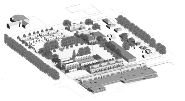
Amended by Ord. 1006 Amended Ord. 926; Added Hemming Project Redevelopment Option Zone (ProZone) on 8/6/2008
Amended by Ord. 1142 Amended Ord. 1115; Repealed Ord. 1006; Amendment of the Hemming Project Redevelopment option Zone (ProZone) on 5/4/2016
Repealed & Reenacted by Ord. 1200 Replaced Ord. 1115 with Amendments; Moved Hemming Project Redevelopment Option (ProZone) to Appendix on 2/6/2019
To develop a lasting mixed use district establishing a linkage between Main Street Rexburg and BYU Idaho. This district's guiding principles of sustainability and permanence is in accordance with the Comprehensive Plan of Rexburg, Idaho.
- Uses. All such categories listed herein and all specific uses contained within them in the Standard Land Use Code will be permitted in the Hemming Pro Zone, subject to the limitations set forth.
- Permitted Principal Uses. The following principal uses and structures, and no others, are permitted in the Hemming Pro Zone: Permitted Use Two-family dwelling (attached to commercial or other nonresidential use) Multiple Family Dwelling (excluded along 2nd West) Apartments (low rise attached to commercial or other nonresidential use as a mixed-use project as set forth in Rexburg City Code) Apartments (high rise attached to commercial or other nonresidential use; as a mixed-use project as set forth in Rexburg City Code) Disabled person residential facility (as part of a mixed-use building, i.e. non-residential uses) Hotels (parking in rear or side yard or garage structure, no parking in front of structure) Automobile parking (long term storage of autos, trucks, boats, vacation trailers, etc.) Gas and electric utility company office Water and electric utility company office Combination utilities right-of-way (identifies areas where surface is devoted exclusively to right-of-way activity) Storm drain or right-of-way (predominantly covered pipes or boxes) Travel Agencies Hardware Building maintenance Department stores (includes major and junior chain department stores) Variety stores Retail trade (as part of a mixed-use building, i.e. residential and/or office) Food stores (groceries, meats and fish, fruits and vegetables, candy, nuts, dairy products, bakeries, etc.) Miscellaneous retail food establishments Apparel, shoes, and accessories Furniture, home furnishings, and equipment (no combined warehousing) Eating places (restaurants) Drug and proprietary stores; health and natural products stores Books, stationery, art, and hobby supplies Sporting goods, bicycles, and toys Garden supplies (entirely within a building only) Jewelry Miscellaneous retail stores (includes florists, cigars, newspapers and magazines, photo supplies, pet –stores, games, computers, electronics, rental tuxedos and gowns, and other similar retail stores) Banks, insurance, and real estate Personal services - including laundry, photography, beauty and barber services, clothing repair, etc. (wedding chapel and reception centers only) Athletic clubs, body building studios, Spas, aerobic centers, (no gymnasiums) Business services (office and retail sales only) Offices and professional services Locksmiths and key shops Professional Services (Behavior, drug and alcohol treatment; office only) Contract construction services (offices and retail only) Executive, legislative, and judicial functions Postal services Educational services Churches, synagogues, temples, and missions Religious reading rooms Other religions activities Cultural activities Video Rental Shops
- Permitted Accessory Uses. Accessory uses and structures are permitted in the Hemming Pro Zone provided they are incidental to, and do not substantially alter the character of the permitted principal use or structure. Such permitted accessory uses and structures include, but are not limited to, the following:
- Accessory buildings such as garages, carports, equipment storage buildings, and supply storage buildings which are customarily used in conjunction with and incidental to a principal use or structure permitted in the Hemming Pro Zone.
- Storage of materials used for construction of a building, including the contractor's temporary office, provided that such use be located on the building site or immediately adjacent thereto, and provided further that such use shall be permitted only during the construction period and thirty (30) days thereafter.
The following uses and structures are permitted in the Hemming Pro Zone only after a Conditional Use Permit has been issued, and subject to the terms and conditions thereof. Conditional Use Bed and Breakfast Inns and Vacation Rentals Dormitory housing (maximum of eight (8) persons per unit Communications (subject to City of Rexburg Telecommunications Ordinance, utilizing feasible “stealth” features to disguise the towers and antennas) Gas company office Motorcycles, motor scooters, parts, accessories, and supplies, as part of a mixed-use building Personal services (wedding chapels and receptions centers only) Vehicle rental (passenger automobiles only) Miscellaneous business services such as Kinkos; limited to not more than twenty percent (20%) of gross leasable are Police protection and related activities, branch (office only) Miscellaneous service organizations Entertainment and assembly including legitimate theater Motion picture theaters (indoor) Public assembly Coin-operated amusements Dance halls, ballroom Ice skating Bowling alleys
Building heights for residential, commercial and mixed use buildings shall not exceed sixty (60) feet.
No requirement except as regulated by the provisions of the latest edition of the Building Code of the City of Rexburg as adopted by the action of the Municipal Council of said City.
- No building or structure, (parking lots included), shall not cover an aggregate area of the development area upon which they are placed.
- If the development area has a recorded contractual agreement to participate in a park, open space area, plaza, or similar, that is located within seven hundred (700’) feet of the site, the development area coverage may be increased to one hundred (100%) percent.
- The park, open space area, plaza, or similar area shall have a minimum area equal in size to the increase of the development area coverage for each participating development area, cumulatively. Required setbacks are not related to development area coverage and therefore must still be observed.
- Individual building and connected structures shall not exceed a forty thousand (40,000) square-foot foot print within the development area.
Lot lines shall be appropriately adjusted, or a Restrictive Lot Line Covenant (RLLC) shall be submitted as part of each development. Lot line modifications and/or RLLC must be approved by the City prior to County recordation.
Not more than forty-two (42) dwelling units may be placed on an acre in the Hemming PRO Zone.
- Adjacent Corners. Corner lots and setbacks are treated the same as two (2) front yards on those adjacent corners.
- Residential Zones. Setbacks when adjacent or across the street from a residential zone should be similar to most restrictive zone, and only applicable to the sides of the proposed building that are visible form residential zone.
- Projections in Setbacks. Permitted projections into setbacks are limited to twenty-five (25%) percent of building frontage and ten (10’) feet projection into setback.
Parking requirements of the development code shall be adhered to except as modified in this section.
- All habitable spaces within the Hemming PRO Zone shall have, within walking distance, automobile parking sufficient to meet the requirements as set forth in Rexburg City Code.
- Parking Surface & Drainage. All surface parking spaces shall be paved with asphalt, cementitious pavers or concrete, and shall be provided with adequate drainage which does not impair public walks or streets.
- Off Street Loading Plan. Off street loading plan will be presented and reviewed by City staff prior to final design approval.
- Parking Stalls. Parking stalls dimensions will comply with section 10.4 of the Development code except that stalls comprising fifty (50%) percent of the total stalls must measure a minimum of eighteen feet by nine feet (18’ x 9’) and fifty (50%) percent measuring a minimum of sixteen feet by nine feet (16’ x 9’).
- Drive Lanes. Drive lanes will be no less than twenty-two (22’) feet wide.
- Required Parking Spaces.
- Gross Leasable Area (GLA) is defined as the sum of all floor area available for lease to retail tenants, including the exterior walls, minus space used for mechanical and elevator equipment, common areas, loading and parking.
- Retail: 2.5 per 1,000 square feet of gross leasable area (GLA).
- Gross Floor Area (GFA) is defined as the sum of all floor area available for lease to office tenants, including exterior walls, minus space used for mechanical and elevator equipment.
- Office: 2.5 per 1,000 square feet of gross floor area (GFA).
- PED. Student housing parking is subject to the Pedestrian Emphasis Zone.
- Married/ Community Housing. Married/community housing: 1.6 parking space per unit ratio.
- Gross Leasable Area (GLA) is defined as the sum of all floor area available for lease to retail tenants, including the exterior walls, minus space used for mechanical and elevator equipment, common areas, loading and parking.
- Bicycle Parking. For any non-residential or multi-family residential buildings, provide short-term and long-term bicycle parking equivalent to five (5%) percent of the total automobile parking on site.
- Short-term. Short-term bicycle parking must be within fifty (50’) feet of the entrance to the building that it services.
- Long-term. Long-term bicycle parking for overnight parking must be in areas sheltered from the elements.
All Project plans for projects in the Hemming Pro Zone must be prepared and engineered by A/E professionals and be submitted for review and approval from conception followed by professional engineered plans and specifications for review by all City Departments and Permitting Authorities.
Building Envelope Standards (BES) ensure that the Hemming Pro Zone fits the character of the community, regulating building height, placement and orientation. The goal of the Building Envelope Standards is the creation of a healthy and vital public realm through good street space. The standards prescribe the ideal. The Building Envelope Standards set the basic parameters governing building construction, including the building envelope (in three dimensions) and certain required/permitted elements, such as canopies, marquees, walls and fences, balconies etc. Buildings are aligned and close to the street. The street is a coherent space with consistent building forms on both sides of the street, contributing to a clear public space. Buildings oversee the street with active fronts and views directed to the street and public realm, conducive to a vital and safe public space. Retail on the ground floor helps to make the street active and interesting and impart a dynamic, vital, and safe pedestrian public space. Parking (not including on-street parking) should be away from the streets and shared by multiple owners/users.
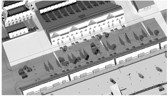
- Uses Within Buildings. All uses established in the Hemming PRO zone shall be conducted entirely within a fully-enclosed building except those uses deemed by the Planning Commission to be customarily and appropriately conducted in the open, and other uses which are allowed by the Planning Commission to be conducted in the open through the granting of a conditional use permit. Uses customarily deemed to be conducted in the open may include, but would not be limited to, service stations, ice-skating, miniature golf, etc.
- Landscaping.
- Surface Parking lots (single level) a minimum of ten (10%) percent landscaping shall be provided for all ground level surface parking lots and shall be useable for snow storage. In addition, parking areas shall be adequately screened from adjacent rights-of-way.
- Signs. (See section 3.5)
- Canopies and Marquees. Canopies and/or marquees may be extended over public sidewalks in the Hemming Pro Zone only after a conditional use permit has been granted by the Planning Commission for their erection, and after a revocable license has been issued by the Rexburg City Mayor in accordance with the procedures outlined herein.
- Said marquees or canopies may be supported by columns or stanchions which are attached to the ground within the public right-of-way and do not extend beyond the street curb line.
- Canopies and marquees erected in the Hemming Pro Zone must comply with all of the following conditions:
- Conditional Use Permit. A conditional use permit must first be granted by the Planning Commission following an application submitted to the Planning Commission. Procedure for granting a conditional use permit for this purpose shall be in accordance with Rexburg City Code.
- Commission Review. Before a license shall be issued by the City the design of the canopy or marquee and the materials used in the construction of said canopy or marquee shall first be reviewed by the Planning Commission in the process of granting a conditional use permit. The Planning Commission shall not grant a conditional use permit for any construction of such canopies or marquees unless the following is fully demonstrated to their satisfaction:
- Design. The canopy or marquee is harmonious in design and appearance with the building upon which it is being located, and with the general architectural and visual theme of the Hemming Pro Zone.
- Canopies or marquees shall remain open and unencumbered on three (3) sides except for required supporting columns, stanchions, or architectural features approved by the Planning Commission.
- Materials. The canopy or marquee will be constructed of materials contained on the materials list for the Hemming Pro Zone approved by resolution of the City Council.
- Objective. The canopy or marquee will tend to improve the visual environment of the City, will not be harmful to any existing tree or landscaping element, will increase downtown property values, and will promote the objectives and characteristics of the Hemming Pro Zone as set forth herein.
- Support. The location of supporting columns or stanchions will not obstruct pedestrian traffic on the sidewalk, and will not materially affect existing landscaping or street furniture installations in the public right-of- way.
- Landscaped Area. In the event that no public landscaping exists in the area adjacent to said canopy or marquee, the Planning Commission shall require the provision of a landscaped and planted area no less than four (4’) feet in width and no greater than six (6’) feet in width to be planted with materials as part of the granting of a conditional use permit. This planting shall be provided at least the full width of the canopy or marquee installation.
- Building Code. All canopy or marquee installations will be in full conformance with the provisions of the latest edition of the Uniform Building Code as adopted by Rexburg City.
- License. A license shall be obtained from the City permitting such construction. Conditions deemed appropriate by City may be imposed upon the granting of a license.
- Revoke. Said license may be revoked after ninety (90) days of written notice to the licensee, at which time all improvements must be removed from the public right-of-way at the full expense of said licensee.
- The City right-of-way shall be restored by the licensee at his own expense to a condition equivalent or better than that existing in the remainder of the block face, and to a condition satisfactory and acceptable to the Mayor.
- Maintenance. The licensee shall agree to save and hold harmless the City on any and all damage to any property or person arising from the construction and maintenance of such canopies or marquees.
- Licensee shall assume and pay all costs of installation, maintenance, and removal of said canopy or marquee.
- The licensee shall agree to pay damages and hold the City harmless from any claim that may arise through the licensee's use of public property for this purpose.
- Right-of-Way. In no event shall any portion of the public right-of-way be used for commercial storage, display, or other private use.
- The construction of any canopy or marquee under the provisions of this Section shall in no way deprive the public of use of the public right-of-way.
- Trash Storage. (See 3.02.120.)
- Walls and Fences.
- Front Yard. No wall, fence, or opaque hedge or screening material higher than thirty-six (36”) inches shall be maintained within a required front yard which would tend to inhibit a safe sight distance of traffic traveling upon a public street, or entering into the public street from a private driveway or alley.
- Residential. The following standards shall apply in all residential projects in the Hemming PRO zone:
- Front Yard. Solid walls, fences, hedges or screening materials which are sight obscuring may be built to a maximum of three (3’) feet in any required front yard perimeter. Walls, fences, hedges or screening materials which are not sight obscuring (at least 50% open) may be built to a maximum of six (6’) feet in a front yard.
- Side Yard. Solid, sight obscuring fences or walls may be built to a maximum of three (3) feet but may slope upward to connect with a higher rear yard fence. The sloped length may not exceed one section or a maximum of ten (10’) feet.
- Rear Yard. Walls and fences in a rear yard may exceed six (6’) feet provided that a building permit is first obtained from the Building Inspection Division prior to construction.
- Corner Lots. A fence not more than six (6’) feet high may be constructed in a side yard adjacent to a public street on a corner lot, provided it does not extend into the clear vision area of a corner lot as defined by Rexburg City Code.
- Entryways. Entry treatments to private driveways or subdivision development entrances may not exceed six (6’) feet at the highest point, except lamps on pillars.
- Pillars. Pillars shall be allowed to extend up to eighteen (18”) inches above the allowable height of a fence provided that the pillars shall have a minimum spacing of no less than six feet, measured face to face.
- Grade Differences. Where there is a difference in the grade of the properties on either side of a fence, wall or other similar structure, the height of the fence shall be measured from the natural grade of the property upon which it is located.
- Retaining Walls. Where a retaining wall protects a cut below or a fill above the natural grade and is located on the line separating lots or properties, such retaining wall may be topped by a fence, wall or hedge of the same height that would otherwise be permitted at the location if no retaining wall existed.
- Privacy Walls. Privacy walls which project into a required front yard will be subject to staff review.
- Double Frontage Lots. A fence or wall may be erected in the rear yard of a double frontage lot subject to staff review.
- Exceptions. The provisions of this Section shall not apply to certain other fences such as tennis court backstops or patio enclosures as approved by the Zoning Administrator, if it is determined that such do not create a hazard or violation of other sections of the Rexburg City Code or other City ordinances. All other exceptions must obtain Planning Commission approval.
- Sidewalk Cafes. A sidewalk café shall be permitted if the following requirements are met:
- An applicant submits scaled plans demonstrating that the café will conform to the following development standards:
- Pedestrians. At least six (6’) feet of clear, unobstructed sidewalk width will remain available for pedestrian use.
- Sidewalk Obstructions. A six (6’) feet clearance shall be required between any portion of the café area and any sidewalk obstructions such as tree wells, street signs, utility poles, newspaper racks, benches, kiosks, drinking fountains and landscaped areas.
- Awnings. Awnings associated with the café will be installed in accordance with the Uniform Building Code.
- Barriers. If the sidewalk café is limited to one row of tables and chairs parallel to the building, no barriers will be erected to impede access.
- Furnishings. Tables, chairs and other furnishings associated with the café will be located directly adjacent to the building and ground floor space in which food or drink is prepared.
- If a sidewalk café is designed to have more than one such row of tables and chairs, a non-sight obscuring removable barrier not more than three (3’) feet high enclosing the tables and chairs shall be constructed.
- Barrier gates shall not swing into the required unobstructed sidewalk area required in subsection (b) above.
- Hours. Hours of café use will be limited to not earlier than 7:00 A.M. and not later than 11:00 P.M. and will not exceed the operating hours of the associated eating or drinking establishment.
- Insurance. Insurance will be continuously maintained to adequately co-insure Rexburg City against any liability associated with the sidewalk café, as reasonably determined by the City. The insurance certificate shall name the City as an “additional insured.” Cancellation of such insurance shall require at least thirty (30) days prior notice to the City.
- Liability. Rexburg City, its officers, agents and employees, will be held harmless from any claims, causes of action, injuries, losses, damages, expenses, fees and costs, including attorneys’ fees, associated or arising from the operation of the café.
- Maintenance. The Café owner and operator will maintain the sidewalk café and surroundings will be maintained in a neat and clean condition at all times.
- Repair. The café owner and operator will be responsible for repair of any damage done to the public sidewalk due to the installation or removal of furnishings, barriers or other features of the sidewalk café.
- Setback. A five (5’) feet setback will be maintained from the dining area to a property or lease boundary and from the intersection of the public sidewalk with a driveway, alley, street or another public sidewalk.
- Sidewalk Repair. The Café owner and operator will remove café improvements if necessary for sidewalk repair or replacement, utility maintenance, or upon failure to comply with the terms of the agreement.
- Signs. Signs associated with the café will be installed in accordance with Rexburg City Code.
- Trash and Tobacco. Adequate facilities for the storage of trash and tobacco waste products generated by the café will be provided at a convenient location.
- Umbrellas. Umbrellas shall not extend into the required unobstructed sidewalk area required in subsection (b) above.
- An agreement between the applicant and the City is executed and recorded that includes the following provisions:
- No alcohol will be consumed on the sidewalk.
- All tables and chairs, any barrier, and other sidewalk obstructions associated with the sidewalk café will be removed during the time period between one-half (½) hour after close of business to one-half (½) hour before opening of the business.
- An applicant submits scaled plans demonstrating that the café will conform to the following development standards:
- Time Limits. If the Hemming Pro Zone is not proceeding with construction of buildings and uses that are substantially the same as proposed and intended during the rezone request, the City shall initiate a reversion to the previous zoning (most recent prior to the PRO Zone designation).
- This time limit shall include a forty-eight (48) month period. The time shall begin at the adoption of the Hemming PRO zone or at each phase.
- Building Permit. Within the forty-eight (48) month period a building permit shall be submitted that requests approval of a substantial building that is consistent with the intent of the Hemming PRO Zone.
- Phases. No new phases shall be considered until at least fifty (50%) percent build out has occurred on previous phases.
- Building Code. The provisions of this Section are not intended to any way nullify or repeal any portions of the Uniform Building Code provisions.
Introduction Development in the Hemming Pro Zone will be guided by overall design standards in harmony with the adopted vision for downtown. These design standards for development will be coordinated with overall community standards and will enhance the integrity of the existing business district and the downtown as the center of the community while providing a link to this new mixed-use district.
- Purpose and Objectives. The basis for all development within our Community is set forth in the Development Code, Subdivision Regulations, and the Comprehensive Plan.
- The Development Code for the City of Rexburg states that the purpose of the Ordinance is to promote the general welfare by establishing and regulating zoning districts.
- The purpose of these standards is to augment the existing criteria contained in the Hemming Pro Zone and those contained in the Development Code and Subdivision Ordinance, with more specific interpretations that apply to the design commercial developments in the Hemming Pro Zone.
- These standards require a basic level of architectural variety, compatible scale, pedestrian and bicycle access, and mitigation of negative impacts.
- Guiding Hemming Pro Zone principals. The City of Rexburg values the historical sense of place that the downtown has provided for over a hundred years. The Hemming Pro Zone will incorporate many of the principals which have guided the downtown. These principals are as follows:
- The Hemming Pro Zone is a Pedestrian-Priority Area.
- The Hemming Pro Zone is Highly Attractive to Visitors.
- The Hemming Pro Zone is a Mixed-Use Center which includes Retail, Office, Residential, Entertainment, Culture and Educational facilities.
- The Hemming Pro Zone is Highly connected to the City, Region and to BYU-Idaho.
- Circulation System Manages “Through” & “To” Traffic Strategically.
- The Hemming Pro Zone Way-finding & Parking Systems are User Friendly.
- The Hemming Pro Zone is a great Place to Work, Visit, Shop, Learn & Live.
- The Hemming Pro Zone Development Framework. The Development Framework that has been identified is as follows:
- Define and Focus Development on Target Markets.
- Emphasize Mixed-Use Development with Ground Floor Retail.
- Build a Sound Parking System for Employees, Customers, Visitors & Residents.
- Undertake Infill, Adaptive Re-Use & Historic Preservation. Implement Urban Renewal Program.
- Install Small Business Amenities & services to Draw this Market.
- Connect to Community & Region with Wayfinding, Gateways, Parking, Amenities & Marketing.
- Recruit Social Retailers to Reconnect with Major Regional Markets.
- Architectural Standards. The Architectural Standards for the Hemming Pro Zone favor an aesthetic that is traditional and reflective of Rexburg’s heritage and environment. They specify an architectural language of quality, durability, and endurance. The intent behind these standards is to utilize a discipline of form in the design in order to foster a coherent aesthetic.
- Exterior Materials. Exterior building materials should express the construction techniques and structural constraints of traditional, long lasting building materials.
- Facades. Facades should be articulated to reduce the massive scale and the uniform impersonal appearances of buildings.
- Roofs and Parapets. Roofs and parapets should demonstrate a commonsense recognition of the climate by utilizing appropriate pitch, drainage, and materials in order to provide visual coherence to the Hemming Pro Zone.
- Green Building. Green building technologies should be used to the maximum extent possible.
- Improvement and Expansion Goals. The Hemming Pro Zone is intended to support the city’s goals through elements of design and appropriate mixed-use development. This chapter provides standards for the orderly improvement [and expansion] design of the Hemming Project based on the following principals:
- Efficient use of land and urban services;
- A mixture of land uses to encourage walking as an alternative to driving, and provide more employment and housing options;
- Both formal and informal community gathering places;
- There is a distinct storefront character which identifies the Hemming Project;
- The Hemming Pro Zone is connected to Downtown, the University, and neighborhoods;
- Provide visitor accommodations and tourism amenities;
- Transit-oriented development reduces reliance on the automobile and reduces parking needs in the Hemming Pro Zone;
- Design standards/guidelines maintain and enhance the City’s historic architecture;
- Block Layout and Building Orientation. This section is intended to promote the walkable, storefront character of the Hemming Pro Zone by orienting (placing or locating) buildings close to streets. Placing buildings close to the street also slows traffic down and provides more “eyes on the street”, increasing the safety of public spaces.
- Applicability. This Section applies to new Land Divisions and all of the following types of development (i.e., subject to Site Design Review):
- Three or more single-family attached townhomes on their own lots (i.e., townhomes subject to Site Design Review);
- Duplex and tri-plex developments with more than one building (i.e., duplex and tri-plex developments subject to Site Design Review);
- Multi-family housing;
- Public and institutional buildings, except that the standard shall not apply to buildings which are not subject to site design review (e.g., buildings used solely to house mechanical equipment, and similar uses); and
- Commercial and mixed-use buildings subject to site design review.
Figure 1b 2 –Hemming Pro Zone block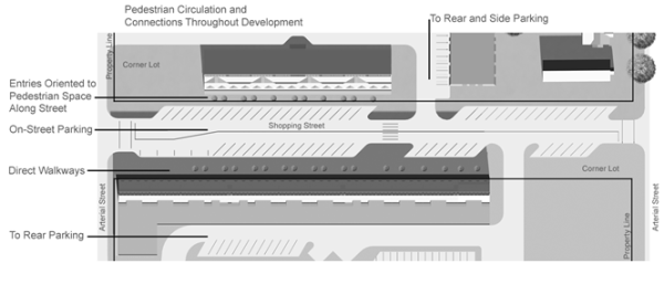
- Hemming Pro Zone Block Development. Commercial and mixed-use developments may exceed the block width and depth standards in ‘B’, above, when the total floor area of those developments (i.e., one or more buildings on one or more lots) exceeds [10,000] square feet on the ground floor. These “superblock developments” shall conform to all of the standards in a-b below (See figure):
- Create a “shopping street”. Each development has at least one street or drive designed with the basic elements of a good pedestrian-oriented shopping street: buildings oriented (placed) close to both sides of a “main street”, which may be public or private; on-street parking; wide sidewalks (e.g., 8-12 feet typical), street trees; pedestrian-scale lighting and other similar enhancements.
- Provide usable pedestrian space. The amount and included amenities of Pedestrian space must be in compliance with the Hemming PRO Zone Design Criteria. Pedestrian space means a plaza or extra-wide pathway/sidewalk near one or more building entrances. The Hemming PRO Zone Design Criteria provides the requirements for street trees or planters, space for outdoor seating, canopies or awnings, and on-street parking (in selected areas).
Figure 1C-1 - Building Orientation (Typical)
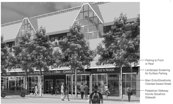
- Building Orientation Standard. The Hemming PRO zone Design Criteria details how all building orientations, including corner lots, are required to be built. All of the developments in the Hemming PRO Zone shall be oriented to a street. The Hemming PRO zone Design Criteria details the setback standards and entrance requirements.
- Clear Vision Areas. Clear vision areas in the Hemming PRO zone are a minimum of fifteen (15’) feet and should be approved by the City Engineer prior to adoption. This applies to main building structures, not accessory structures or landscaping, which require the thirty (30’) feet clear vision area.
- Building Height. All buildings in the Hemming Pro Zone shall comply with the following build–ng height standards. The standards are intended to allow for development of appropriately-scaled buildings with a storefront character:
Figure 2-1 - Building Height Diagram (Credit for Housing)
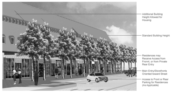
- Maximum Height. Buildings shall be no more than five (5) stories or sixty (60’) feet in height, whichever is greater.
- Roof top equipment is not included in the maximum building height but should be screened by parapets or similar treatment.
- Method of Measurement. “Building height” is measured using the same method of measurement as described for all Zones within the Rexburg Development Code, Ordinance No. 1026
- Specific Architectural Guidelines.
- Purpose and Applicability. Design Criteria for the Hemming PRO Zone will be presented to the Design Review Committee (DRC) or designee for review and approval prior to implementation. Upon approval, all new construction will comply with this criterion.
- Guidelines and Standards. Each of the following standards shall be met.
- An architectural feature used to comply with one standard may be used to comply with another standard.
- The Hemming Pro Zone architectural guidelines or standards are intended to provide detailed, human-scale design, while affording flexibility to use a variety of building styles.
- This section applies to all of the following types of buildings:
- Three or more single-family attached townhomes on their own lots (i.e., townhomes subject to Site Design Review).
- Duplex and tri-plex developments with more than one building (i.e., duplex and tri-plex developments subject to Site Design Review).
- Multi-family housing.
- Public and institutional buildings, except that the standard shall not apply to buildings which are not subject to site design review or those that do not receive the public (e.g., buildings used solely to house mechanical equipment, and similar uses).
- Commercial and mixed-use buildings subject to site design review.
Figure 3-1 – Hemming Pro Zone Building Design Elements (Typical)
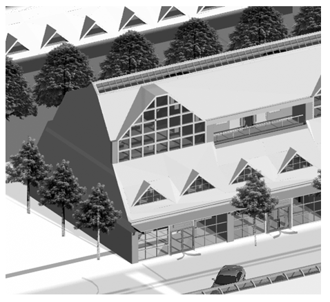
- Detailed Storefront Design. All buildings shall contribute to the storefront character and visual relatedness of the Hemming Pro Zone buildings. This criterion is met by providing all of the architectural features listed in a-c, below along the front building elevation (i.e., facing the street), as applicable and by complying with the Hemming PRO zone design criteria. Corner buildings will be subject to application of the standards to both street facing elevations and be approved under the Hemming PRO zone Design Criteria.
- Corner building entrances on corner lots. Alternatively, a building entrance may be located away from the corner when the building corner is beveled or incorporates other detailing to reduce the angular appearance of the building at the street corner.
- Regularly spaced harmonious proportionate scaled window openings (all building stories).
- Display Windows. Large display windows on the ground-floor (non-residential uses only). Display windows shall be framed by bulkheads, piers, and sills.
- Sill height shall be at a minimum of eighteen (18”) inches for seventy-five (75%) percent of such display windows.
Figure 3-2 - Design of Large-Scale Buildings and Developments (Typical)
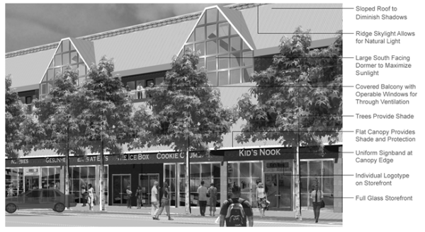
- Sill height shall be at a minimum of eighteen (18”) inches for seventy-five (75%) percent of such display windows.
Figure 3-2 - Design of Large-Scale Buildings and Developments (Typical)
- Design of Large-Scale Buildings and Developments. The standards in subsection “c”, below, shall apply to “Large-Scale Buildings and Developments”, as defined in a-b and the approved Hemming PRO Zone Design Criteria:
- Building Size. Buildings with greater than twenty-five-thousand (25,000) square feet of enclosed ground-floor space (i.e., “large-scale”). Multi-tenant buildings shall be counted as the sum of all tenant spaces within the same building shell.
- Multi-building Developments. Multiple-building developments with a combined ground-floor space (enclosed) greater than forty-thousand (40,000) square feet (e.g., shopping centers, public/institutional campuses, and similar developments).
- Human Scale. All large-scale buildings and developments, as defined in a-b, shall provide human-scale design by conforming to all of the following criteria:
- Building Direction, Variation. Incorporate changes in building direction (i.e., articulation), and divide large masses into varying heights and sizes, as shown above. Such changes may include building offsets; projections; changes in elevation or horizontal direction; sheltering roofs; terraces; a distinct pattern of divisions in surface materials; and use of windows, screening trees; small-scale lighting (e.g., wall-mounted lighting, or up-lighting); and similar features. (Note: the example shown above is meant to illustrate examples of these building design elements, and should not be interpreted as a required architectural style.)
- Entrances. Every building elevation adjacent to a street with a horizontal dimension of more than one-hundred [100] feet, as measured from end-wall to end-wall, shall have a building entrance; except that building elevations that are unable to provide an entrance due to the internal function of the building space (e.g., mechanical equipment, areas where the public or employees are not received, etc.) may not be required to meet this standard.
- Streetscape Standards. The Streetscape Standards are intended to further insure the coherence of the aesthetic for the Hemming Pro Zone. These standards also establish an environment that encourages and facilitates pedestrian activity. Native trees and plants contribute to privacy, noise reduction, maintenance of the natural habitat, and conservation of water. The Streetscape is key to the livability, vitality and identity of the Hemming Pro Zone.
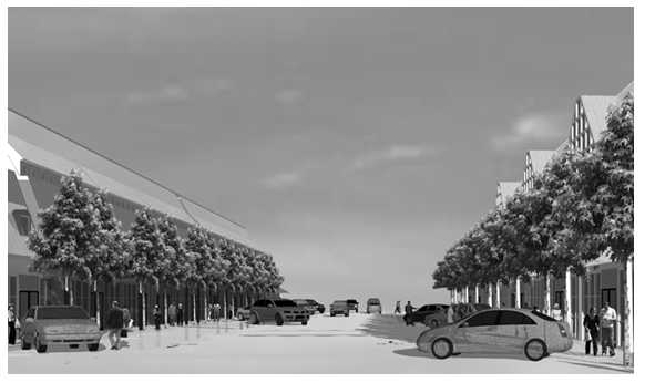
- Streetscape Elements. Streetscape elements, such as pavers, benches and other outdoor seating, amenities for transit passengers, pedestrian scale street lights, bike racks and waste-bins must be consistent throughout the Hemming Pro Zone.
- Trees. Street trees are part of an overall Streetscape plan designed to give special character and coherence. The desired aesthetic shall be achieved through the use of native/proven, hardy, adaptive species where reasonable.
- Applicability. This Section applies to new Land Divisions and all of the following types of development (i.e., subject to Site Design Review):
- Pedestrian (and Transit) Amenities. This section is intended to complement the building orientation standards above, as well as the street standards by providing comfortable and inviting pedestrian spaces within the Hemming Pro Zone. Upon approval, all new construction will comply with these criteria. Pedestrian amenities serve as informal gathering places for socializing, resting, and enjoyment of the Hemming Pro Zone and contribute to a walkable district. This section applies to all of the following types of buildings:
- Three or more single-family attached townhomes on their own lots (i.e., townhomes subject to Site Design Review).
- Duplex and tri-plex developments with more than one building (i.e., duplex and tri-plex developments subject to Site Design Review);
- Multi-family housing;
- Public and institutional buildings, except that the standard shall not apply to buildings which are not subject to site design review or those that do not receive the public (e.g., buildings used solely to house mechanical equipment, and similar uses); and
- Commercial and mixed-use buildings subject to site design review.
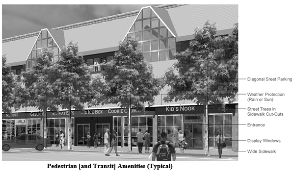
This section supplements the standards contained above. It provides standards for the following land uses in order to control the scale and compatibility of those uses within the Residential District: - Residential Uses - Bed and Breakfast Inns and Vacation - Rentals - Public and Institutional Uses - Accessory Uses and Structures - Automobile-Oriented Uses and Facilities - Outdoor Storage and Display - Light Manufacture
- Residential Uses. Higher density residential uses, such as multi-family buildings and attached townhomes, are permitted to encourage housing near employment, shopping and services.
- Objectives. All residential developments shall comply with the standards in 3-6, below, which are intended to require mixed-use development; conserve the community’s supply of commercial land for commercial uses; provide for designs which are compatible with a storefront character; avoid or minimize impacts associated with traffic and parking; and ensure proper management and maintenance of common areas.
- Reconstruction or Expansion. Residential uses which existed prior to the effective date of this code are exempt from this Section unless substantial reconstruction and/or expansion occurs.
- Substantial reconstruction shall mean that valuation of proposed improvement exceeds fifty (50%) percent of assessed value for the previous calendar year.
- Standards shall only apply to areas of expansion unless the gross floor area of the proposed expansion exceeds fifty (50%) percent of the existing structure’s gross floor area.
- Common Areas. All common areas (e.g., walkways, drives, courtyards, private alleys, parking courts, etc.) and building exteriors shall be maintained with a lease agreement.
- Density. There is a maximum dwelling density of forty-two (42) units per (1) acre.
- Mixed-Use Development Required. Residential uses shall be permitted only when part of a mixed-use development (residential with commercial or public/institutional use). Both “vertical” mixed-use (housing above the ground floor), and “horizontal” mixed-use (housing on the ground floor) developments are allowed, subject to the standards in 2-5 of this section.
- Parking, Garages, and Driveways. All off-street vehicle parking, including surface lots and garages, shall be oriented to alleys, placed underground, placed in structures above the ground floor, or located in parking areas located behind or to the side of the building.
- Entrance Facing Street. All garage entrances facing a street (e.g., underground or structured parking) shall be recessed behind the front building elevation by a minimum of [4-6] feet.
- Corner Lots. On corner lots, garage entrances shall be oriented to a side-street (i.e., away from (name of “Main Street”)) when access cannot be provided from an alley.
- Bed and Breakfast Inns and Vacation Rentals. Bed and Breakfast Inns and vacation rental dwellings are required to register with a local management group or make available at all times a local contact.
- Bed and Breakfast Inns must be owner occupied using a maximum of twenty-five (25%) percent of the home for this purpose.
- Public and Institutional Uses. Public and institutional uses are allowed in the Hemming PRO zone, except that automobile-oriented uses shall comply with the standards in “e”, below.
- Accessory Uses and Structures. Accessory uses and structures are of a nature customarily incidental and subordinate to the principal use or structure on the same lot. Typical accessory structures in the Hemming Pro Zone include small workshops, greenhouses, studios, storage sheds, and similar structures.
- Accessory uses and structures are allowed for all permitted land uses within the Hemming Pro Zone provided they are incidental to, and do not substantially alter the character of the principal permitted use.
- Standards. Accessory structures shall comply with the following standards:
- Primary use required. An accessory structure shall not be allowed before or without a primary use on the same lot.
- Setback standards. Accessory structures shall comply with the setback standards required by the building code. If and accessory structure requires a building permit, all setbacks required of the principal structure shall be observed as well.
- Front Yard. In addition, no accessory structures shall be allowed to encroach in to a front yard.
- Materials. Accessory structures visible from public or private rights-of-way shall be consistent in materials as those used for the principal structure.
- Design guidelines. Accessory structures shall comply with the Hemming Pro Zone design guidelines.
- Restrictions. A structure shall not be placed over an easement that prohibits such placement. No structure shall encroach into the public right-of-way.
- Compliance with subdivision standards. The owner may be required to remove an accessory structure as a condition of land division approval when removal of the structure is necessary to comply with setback standards.
- Automobile-Oriented Uses and Facilities. Automobile-oriented uses and facilities, as defined below, shall conform to all of the following standards in Hemming Pro Zone. The standards are intended to provide a vibrant storefront character, slow traffic down, and encourage walking.
- Definition. “Automobile-oriented use” means automobiles and/or other motor vehicles are an integral part of the use. These uses are restricted because, when unrestricted, they detract from the pedestrian-friendly, storefront character of the district and can consume large amounts of land relative to other permitted uses.
- Parking, Garages, and Driveways. All off-street vehicle parking, including surface lots and garages, shall be accessed from alleys, placed underground, placed in structures above the ground floor, or located in parking areas located behind or to the side of a building; except that side-yards on corner lots shall not be used for surface parking.
- All garage entrances facing a street (e.g., underground or structured parking) shall be recessed behind the front elevation by a minimum of four (4’) feet.
- Individual surface parking lots shall not exceed a total one-half city block; larger parking areas shall be in multiple story garages.
- Standards. Automobile-oriented uses shall comply with the following standards:
- Vehicle repair, sales, rental, storage, service. Businesses that repair, sell, rent, store, or service automobiles, trucks, motorcycles, buses, recreational vehicles/boats, construction equipment, and similar vehicles and equipment are prohibited unless the use is contained within an enclosed building.
- Drive-up, drive-in, and drive-through facilities. Drive-up, drive-in, and drive-through facilities (e.g., associated with restaurants, banks, car washes, and similar uses) are permitted only when accessory to a primary commercial “walk-in” use, and shall conform to all of the following standards:
- The facility receives access from an alley or driveway, and not a street
- Street Location. None of the drive-up, drive-in or drive-through facilities (e.g., driveway queuing areas, windows, teller machines, service windows, drop-boxes, and similar facilities) are located within twenty (20’) feet of a street and shall not be oriented to a street corner. (Walk-up only teller machines and kiosks may be oriented to a corner).
- Subordinate to Primary. The facility is subordinate to a primary permitted use. “Subordinate” means all components of the facility, in total, occupy less street frontage than the primary commercial or public/institutional building.
- Street Frontage. No more than one drive-up, drive-in, or drive-through facility shall be permitted on one block, or for a distance of three-hundred (300’) linear feet along the same street frontage, whichever is less.
- Outdoor PA System. No outdoor PA system shall be located within three hundred (300’) feet of a residential zone.
- Sidewalk Displays. Sidewalk display of merchandise and vendors shall be limited to cards, plants, gardening/floral products, food, books, newspapers, bicycles, and similar small items for sale or rental to pedestrians (i.e., non-automobile oriented).
- A minimum clearance of six (6’) feet of walkable surface shall be maintained.
- Display of larger items, such as beds and appliances, automobiles, trucks, motorcycles, buses, recreational vehicles/boats, construction equipment, building materials, and similar vehicles and equipment, is prohibited.
- Light Manufacture. Certain light manufacture uses are allowed in the Hemming Pro Zone.
- Definition. “Light manufacture” means production or manufacturing of small-scale goods, such as crafts, electronic equipment, bakery products, printing and binderies, furniture, and similar goods.
- Commission. The Planning and Zoning Administrator may determine at any time during the review process of a manufacturing use that it may be submitted to the Planning Commission or City Council as a conditional use permit.
- Standards. Light manufacture uses shall conform to all of the following standards which are intended to protect the pedestrian-friendly, storefront character of the Hemming Pro Zone.
- Retail or Service Use Required. Light manufacture is allowed only when it is in conjunction with a permitted retail or service use [and does not exceed fifty (50%) percent of the gross floor area].
- Location. The light manufacture use shall be fully enclosed within a building and shall not be located within two hundred (200’) feet of a residential zone.
Lighting Standards are applicable as described in Section 3.6.